All Activity
- Past hour
-
 Dodging drops in Henniker (NH) at sunset.
-

Big Heat (and storms?) Week into July 4th Weekend
nw baltimore wx replied to yoda's topic in Mid Atlantic
Just say what you want to say. -
 I seem to recall a few sites got the ceilometer upgrade going back several years, but I haven't heard much since. AWOS-4 does not mention it has this upgrade.
 -

E PA/NJ/DE Summer 2026 Obs/Discussion
LVLion77 replied to PhiEaglesfan712's topic in Philadelphia Region
Not as crazy as last night but a bit more rain at a little over 1/2”. -
 Man times flies. I know most AWOS’s were upgraded to 3PT for precip ID and temp remarks (LCI and EEN got it up here), but I thought it was more recent than that. But now that you mention it I do remember the old 20 minute obs that used to come out of there with the original AWOS. BTW, whatever happened with the 25k ceilometer rollout? I thought that was happening 10-15 yrs ago and instead only some of the manned sites report/augment it in. There’s nothing more stupid in weather reporting than reporting an overcast layer at 13kft as “CLR”
 -
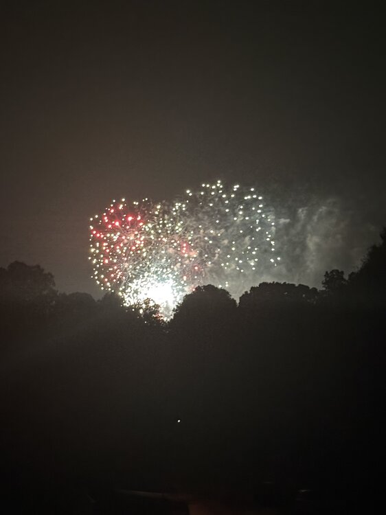
Storms rolled through and cooled it down nicely for the Great Falls fireworks. 72 degrees. Happy 250th!
-
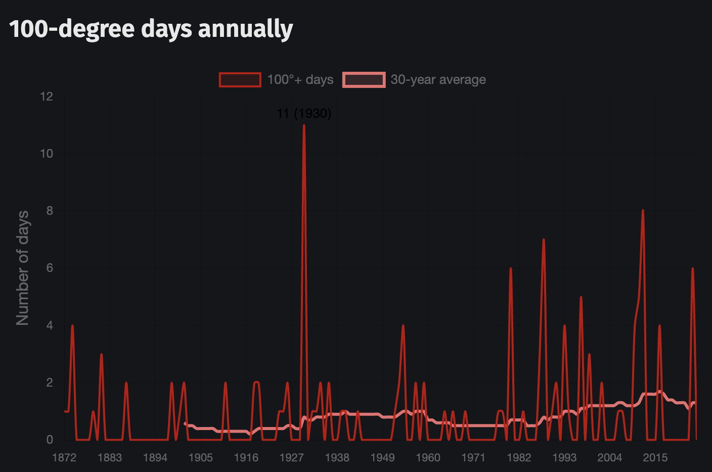
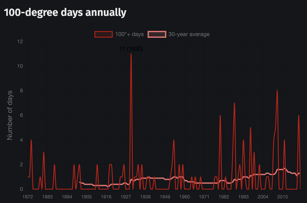
see if you can spot the trend!!!
-
 Barely a drop
 -
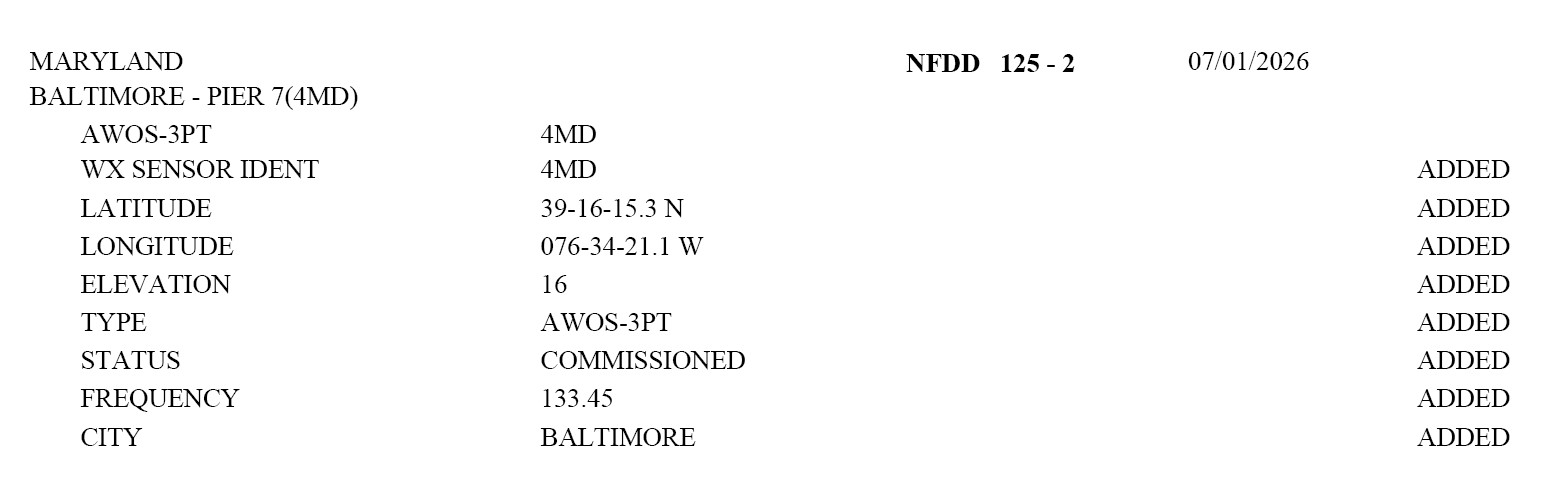
And I just came across this. An AWOS was just commissioned at the Pier 7 Heliport in Baltimore. https://www.airnav.com/airport/4MD So a site to compete w/ the furnace that KDMH is? LOL. The site METARs are not on the WMSCR/NCEP feeds currently. Not sure if they will be, but if they are added, I will let the forum know. No AWOS phone number was listed in the NFDD entry (see attachment).

-

E PA/NJ/DE Summer 2026 Obs/Discussion
BBasile replied to PhiEaglesfan712's topic in Philadelphia Region
4th Of July Weekend thunderstorms and fireworks. Looking to add to this over the next couple days... Hopefully. -
That looked like a different cell that developed right over you guys
-

Big Heat (and storms?) Week into July 4th Weekend
BlizzardNole replied to yoda's topic in Mid Atlantic
OK that was a rough go in central Calvert. We had some 50-60 mph gusts with a lot of branches down and a pine tree that snapped and partially fell on my new shed. Inside looks OK but not sure about the roof until I can get it off. Brief torrential rain, lots of close lightning and some pea-sized hail. We lost power for around an hour. Nearby Mesonet has 0.89. I hope there's a lot more in coming days Funny thing as more t-storms have been coming through and these people down here just kept right on shooting off fireworks and hooting LOL -
 3k Nammy is absolutely hellacious in Connecticut Monday and Tuesday.
 -
That storm weakened right as it passed over me, 0.14" total.
-
-
Missed the heavy storms but thankfully some decent rain moving in now. Looks like high end moderate rain. Should get at least a quarter inch from this.
-
And I will post this again for reference. Go figure! Washington DC ended a streak of 2867 days w/o 100 F reading on 6/22/2024. This is the 5th longest period on record since 1872.
-
DOV is indeed an ASOS (DoD run). BLM is a Federal AWOS, AO2 shows up both on ASOS and AWOS. Most AWOS are privately-owned, but that does not seem to change the equipment/sensor issues whether is Federal or private. One way you can tell a non-Federal from Federal AWOS or ASOS is the SLP group. if it is missing, that's a non-Federal AWOS. About 10 years ago. all Federal AWOS got upgraded so they basically report just like ASOS. First Federal AWOS were installed in 1989 (KILE, KPWT, and KFOD were the first I think). I attached a list of all Federal AWOS. federalawos.txt
-

Central PA Summer 2026 Discussion/Obs Thread
CarlislePaWx replied to Voyager's topic in Upstate New York/Pennsylvania
Here in Carlisle...it appears that my immediate area, about 1 mile south of I-81 at the Hanover St. exit 47, were spared the severe aspects of the warned storm back around 6:30pm. No hail. I estimate max wind gusts of 35-45mph briefly as the downdraft came blowing through. I only ended up with 0.11" of rain. The thermometer broke the century mark for the 3rd day in a row, reaching 100.8 around 4:00pm. Yesterday's high was 102.0 and Thursday's high was 101.6. I'm almost positive this is the first time in my life that I have recorded 3 consecutive days of 100+ degree readings. Another event here that I had never previously experienced before was back in January when for 4 consecutive nights my low temperature dropped to zero and below, the lowest being my all-time lowest recorded minimum temperature of -9.6 degrees F. That was during the 3-week long cold wave we all experienced right after the snowstorm that dumped 7.5" here but widespread totals east of here. Some stations saw 18" out towards Lancaster county and further east. Thankfully, the end of this torrid heatwave has finally arrived with much needed rainfall coming and with temps only in the 70's the next several days and then 80's for the remainder of the 7-day forecast. -
Suffolk gets these sneaky severe storms every summer. Usually not forecasted. They drop down from the sound and crush
-

Central PA Summer 2026 Discussion/Obs Thread
Jns2183 replied to Voyager's topic in Upstate New York/Pennsylvania
This is from Maryland but that is legit how it looked here when it hit https://x.com/i/status/2073589620823007409 Sent from my SM-S731U using Tapatalk -
Finally got below 100 at 6:40pm and below 90 at 10:15pm.
-
My power is out and I have no AC. It's actually not that bad and so far I have been able to avoid knee jerk emotional reactions and human fallacies but FOR HOW MUCH LONGER?
-
This Suffolk storm was far more robust than hi res models had it. The models show the stuff to the west swing through during the overnight. So there probably will be more a little later.