All Activity
- Past hour
-
Humidity here wasn’t bad. Def not hazy. And 83.5 wasn’t really hot. very enjoyable. Wish it was warmer.
-
Drizzle. What looked very promising just completely dried up. I'm trying to understand what was over nenj/nyc are to cause it to literally evaporate?
-
Will that line of storms make it here this time or will it dry up too over LI?
- Yesterday
-

E PA/NJ/DE Summer 2025 Obs/Discussion
RedSky replied to Hurricane Agnes's topic in Philadelphia Region
Round one only a graze. Round two looks weak. -
Hartford county is getting rocked today. Tornado warning there now.
-
That poor spot in eastern Balt county and west harford county has been getting killed today. I am just to the west of it thank god.
-
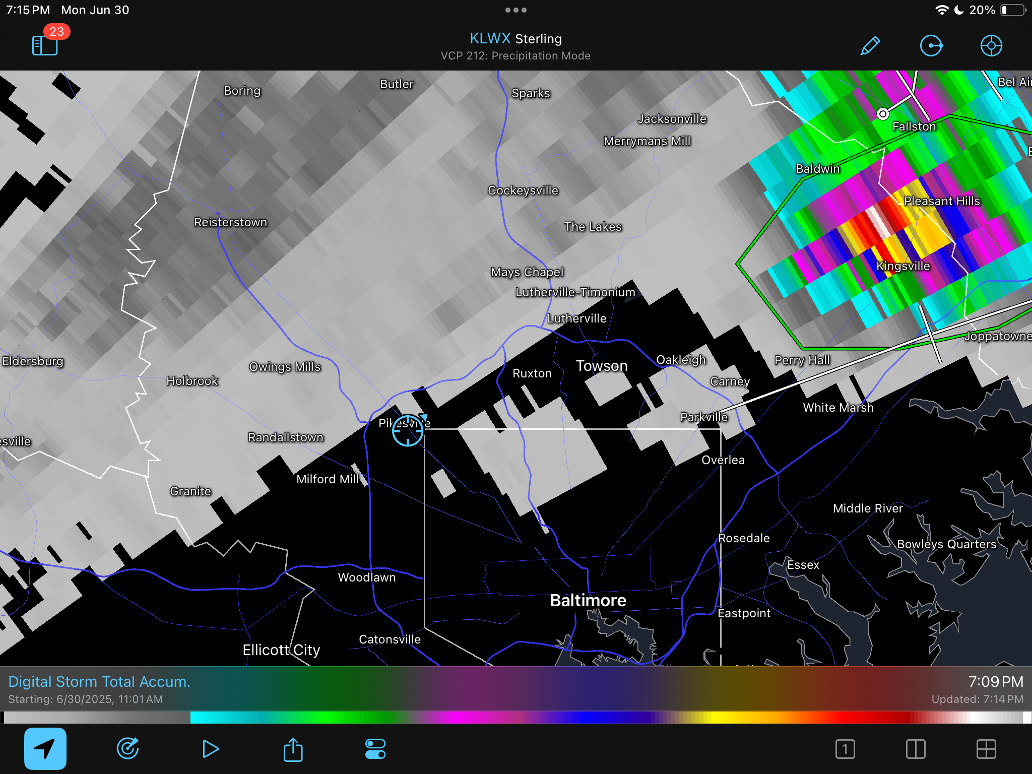
TORNADO WARNING Tornado Warning MDC005-025-010015- /O.NEW.KLWX.TO.W.0028.250630T2339Z-250701T0015Z/ BULLETIN - EAS ACTIVATION REQUESTED Tornado Warning National Weather Service Baltimore MD/Washington DC 739 PM EDT Mon Jun 30 2025 The National Weather Service in Sterling Virginia has issued a * Tornado Warning for... Central Harford County in northern Maryland... East central Baltimore County in northern Maryland... * Until 815 PM EDT. * At 739 PM EDT, a severe thunderstorm capable of producing a tornado was located over Kingsville, or 8 miles north of Middle River, moving east at 15 mph. HAZARD...Tornado. SOURCE...Radar indicated rotation. IMPACT...For those in the direct path of a tornado touchdown, flying debris will be dangerous to those caught without shelter. Damage to roofs, siding, and windows may occur. Mobile homes may be damaged or destroyed. Tree damage is likely. * This dangerous storm will be near... Bel Air South, Bel Air North, Riverside, Pleasant Hills, and Perryman around 745 PM EDT. Other locations impacted by this tornadic thunderstorm include Fork, Benson, Joppatowne, Harford Furnace, Abingdon, Joppa, Upper Falls, Gunpowder, Belcamp, and Bradshaw. PRECAUTIONARY/PREPAREDNESS ACTIONS...
-
That poor spot in eastern Balt county and west harford county has been getting killed today. I am just to the west of it thank god.
-
Flash Flood Watch until 11? I'm confused lol. What's with the flood watches this season. Like i said earlier. Looks like most of us get a break today.
-
Today was HHH. Welcome to the team!
-
https://extension.psu.edu/leaf-galls-on-maple
-
Second warned storm of the day on our doorstep.
-
Guys...what a storm we had here! It started at around 4:10. At first it was a decent rain swath but not much with any real intensity. However, as time rolled on the storms gradually kept getting strong with heavier rain and increasing wind. Then, NWS issued a severe thunderstorm warning saying the storm was over Carlisle and was only moving northeast at 5 mph. In the warning they said possible wind gusts to 70 mph and 1.00" hail. Fortunately for me there ended up with no hail. But the winds easily were sustained at 25-35 with gusts to 45 or even higher. My huge 90-foot tall trees in my backyard began to sway violently as debris being blown off the trees crashed into my picture window. It was terrifying for a bit because the winds were blowing from behind the trees towards the back of my house. That height is enough to reach my house if one came down directly. At the same time it was, of course, strangely exciting at the same time. The torrential rain which was being blown horizontally was adding up incredibly quickly. When it finally began to taper off I had recorded 1.88" in just 45 minutes. Then came the flash flood warning. Thankfully I do not live in a flood prone area. At around 4:55 the lights flickered and then went out. PPL says about 1100 customers without power in the small grid that serves my local area. Restoration expected by 2:00am. We have underground utilities all around here so I know the problem couldn't have originated here. As I type this at 6:30 I picked up another 0.03" in another shower giving me a storm total of 1.91". That brings my monthly total to 6.41". My 2-month total of May plus June comes out to 15.22"! I'll stop here for the time being...lol. ttyl
-
NAM did well up here. A little earlier than I saw but it was quite an electrical storm
- 1,230 replies
-
- 3
-

-
- severe
- thunderstorms
- (and 2 more)
-
I loathe summer.

-
91 here 11 days this month
-
Im in Disney all week but my weather station on Lebanon showing torrential rains there. Almost 3.50” in the bucket so far today with over 2.50” of that falling in the last 90 mins and still pouring .
-
Power is out. Crazy lightning here now.
-
Central Park finally reached 90 this afternoon.
-
2010 was perfect beginning to end
-

June 2025 discussion-obs: Summerlike
LongBeachSurfFreak replied to wdrag's topic in New York City Metro
Absolutely zero surprise there. -
what are you doing out there and in which part, Ant?
-

July 2025 Discussion-OBS - seasonable summer variability
LibertyBell replied to wdrag's topic in New York City Metro
They were Sonoran heat releases directly out of the southwest LOL -
.05” for me today it appears. What a radar lying session.
-
I love June for days like the past two.