All Activity
- Past hour
-

December 2025 Short/Medium Range Forecast Thread
Carvers Gap replied to John1122's topic in Tennessee Valley
The 0z EPS has a much different solution than any other global ensemble including the AIFS. The GEFS, GEPS, and AIF still have the cold shot next weekend. The 6z GFS has a the Christmas Eve cold shot(which really could go either way). I think this is the MJO. The EURO at range has struggled so far during late fall and winter. It certainly is good enough to score a coupe, but it erroneously called for the beginning of December to be warm(after the weeklies had it cold). I would suspect there is a severe cold shot headed into the Lower 48. Things get scrambled when that happens. -
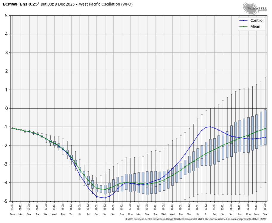
The models have been correcting colder so far this month after showing warmth in the long range. I believe it will continue as along as the WPO stays negative. Look at the gefs correcting.

-
Yep, white. Started as all snow here, although it did warm up a bit late overnight. Went to bed a little past 1 am at 28.0/26.3 and currently 32.2/29.8 with moderate snow.
-
Cold pattern breaks down by Christmas…and never comes back aka 2022-23[emoji23]?
-
Some of those spots will have my normal December snowfall between these two storms. I mean you just have to laugh.
-
Radar looks really good up in parts of northern Virginia right now!
-
There is a lag in the MJO response . Lets see where we are at in a week.
-

December 2025 regional war/obs/disco thread
WxWatcher007 replied to Torch Tiger's topic in New England
Winter storm warnings from Roanoke to Williamsburg…can’t make it up. -
Sounds about right.
-

December 2025 regional war/obs/disco thread
Baroclinic Zone replied to Torch Tiger's topic in New England
We stay the course. Multiple threats possible beginning mid week into end of following week. -

The Monday wintry event potential (12/8/25)
kvegas-wx replied to GaWx's topic in Southeastern States
We're going to see token flurries as this system pulls away and we wave goodbye. Temps shot up to 38 with DPs to match. -
There’s a chance. But it really has to be timed right.
-

December 2025 regional war/obs/disco thread
Snowcrazed71 replied to Torch Tiger's topic in New England
We can't get one model run to be correct when it comes to snow for our area, I'm talking about Southern New England. But we get a map showing a warm Christmas Eve.... Now for some reason I think that's going to be right LOL In all honesty, light snow would be fine for Christmas Eve or Christmas Day, but I don't want a storm. My sis has a very big Christmas Eve shindig every year and it's a great time. But damn it, let's get some snow in here!!! -
Yeah but that was more from massive NAO blocking.
-

December 2025 regional war/obs/disco thread
mahk_webstah replied to Torch Tiger's topic in New England
Squalls Christmas morning? White Christmas? -
The snow hits behind the front so what is happening ahead of it is not as important. Most areas probably will start as some rain before changing over. The previous event was WAA this one is more anafrontal with cold air feeding in (Cold Air Advection).
-

E PA/NJ/DE Winter 2025-26 Obs/Discussion
Mikeymac5306 replied to LVblizzard's topic in Philadelphia Region
Pop open the Champagnie! Euro has mood flakes for next weekend! -
That may work in your favor about a week from now…
-

December 2025 regional war/obs/disco thread
Go Kart Mozart replied to Torch Tiger's topic in New England
Skynet with a robust little snowstorm early next week. -
Windows open baby.
-
December 2025 regional war/obs/disco thread
Snowcrazed71 replied to Torch Tiger's topic in New England
It's crazy, it's happening all over again. Everything that shows some kind of possibility of a storm either fizzles out or gets pushed out. So wasn't it 2010 where New York City South got some great storms and we missed out on most of the snow? -
Rain for the past hour or two has finally now begun its transition to snow here in Blacksburg. Once it goes to snow, it'll come down fast.
-
Definitely not. It's going to get squashed south by the driving cold. Pretty disgusting lol
-
Just wait a run or two. We have no idea whats happening 5 plus days from now. Every run is a different roll of the dice. Just look for signals. I still say most Decembers where I grew up (Granby) were nearly snowless until at least Christmas, aside from a dusting here or there. I find it unusual to have 3 inches OTG here right now
-
6z Euro has it, but a bit weaker.