All Activity
- Past hour
-
Idk if you hit it last year but last time I remember widespread 100s on the south shore was 2011, I peaked at 99 last june
-
96.8 with a heat index of 107
-
 Well, I'm more concerned about the Canadian wildfires smoking out the celebrations, if the HRRR is correct. Just noting the air quality could be even worse when you combine that with fireworks.
 -
Up to 99
-
95 here as well.
-
IAD is about to be clouded over if you believe the visible satellite.
-
97/72 in Lindenhurst, heat index 106
-
.thumb.gif.f92b16c631a1d15d405ed77b33f0710d.gif) quite the Steined heatwave. theyre becoming more frequent it seems
quite the Steined heatwave. theyre becoming more frequent it seems -
So close to record heat and here comes worthless clouds lol
-
98/75 here
-
94/104
-
97 here as of noon.
-
Noon obs: DCA: 97 BWI: 97 (has been to 98) IAD: 93
-
Noon ROund up ACY: 101 New Brnswck: 100 EWR: 99 JFK: 99 PHL: 98 BLM: 98 NYC: 96 TTN: 96 TEB: 95 ISP: 95 LGA: 94
-

Central PA Summer 2026 Discussion/Obs Thread
Itstrainingtime replied to Voyager's topic in Upstate New York/Pennsylvania
Wow! I'm just one degree lower than yesterday at noon. I seem to be catching up... -
Some clouds showing up and temps still rising Current conditions at Wilmington Airport (KILG) Lat: 39.67°NLon: 75.61°WElev: 72ft. Fair 99°F 37°C Humidity 46% Wind Speed N 5 mph Barometer 30.03 in (1016.6 mb) Dewpoint 75°F (24°C) Visibility 10.00 mi Heat Index 112°F (44°C) Last update 3 Jul 11:51 am EDT
-

-

-
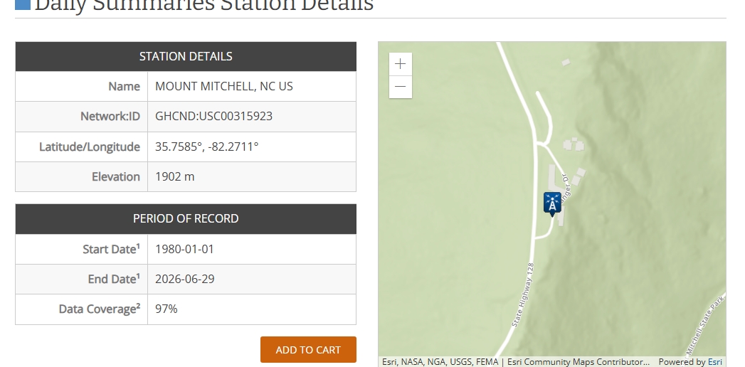
It appears to different high temps at Mt Mitchell yesterday. Never really gave much thought until now----- but the 75 F (NWS local data from Greer) from the MOUNT MITCHELL, NC site and 78.4 F from Mount Mitchell State Park (operated in cooperation NCDEQ and NC Climate Office). As best I can tell, they are both at the same location, but slightly different official elevations and also LAT/Longs. One is 1902 meters and the other is 1894. Does anyone know why the differences? The elevations could be a reporting error on one but was wondering if two instrument locations or just co-located? Just a little surprised by the temp differences----maybe just me?

-
It was a solid (not to mention gross & uncomfortable) heatwave for sure but definitely fell short of hype locally. Which i knew would happen and called it last week in a local weather chat im on. One of the local mets said he sees "nothing" that would indicate we fall short of 100 on back to back days (Wed/Thu). They also hyped 110+ heat indexes. The reality? DTW highs were 94, 97, 96 (likely low 90s today). Max heat index was on July 1st at 105. Max dewpoint was 76, also on the 1st. No record highs were set but the record high min of 76 was tied on the 2nd.
-
Hows the water tmeps?
-
Westminster and Baltimore Inner Harbor both at 99°. The Baltimore City mesonet site is up to 96°.
-

Central PA Summer 2026 Discussion/Obs Thread
canderson replied to Voyager's topic in Upstate New York/Pennsylvania
KMDT hit 100 before noon. Insanity -
Don’t think it’s getting as hot around here today at least. In Westminster right now and it’s getting decently cloudy.
-

Central PA Summer 2026 Discussion/Obs Thread
Jns2183 replied to Voyager's topic in Upstate New York/Pennsylvania
Everything I did for chester I've done for Schyukhill also, except at 800m grid . Over 3600 grid cells. By weekend end I should have a fun little expose on the wild and wacky climate up there Sent from my SM-S731U using Tapatalk