All Activity
- Past hour
-
 Yes, down here there was
 -

Overnight Wednesday, November 5, 2025 Wind Event
WxWatcher007 replied to weatherwiz's topic in New England
Yeah and again…don’t want to make too much of it right now, but even that coastal in October was a pretty meh dual low mess. I get why people are cautiously optimistic about winter but the raging PAC jet interfering in the development of proper coastal and placement of important features is something to watch, I think. I’m being a little colorful, because we can do various types of high end wx, but the return time and regional scale vary. -

Overnight Wednesday, November 5, 2025 Wind Event
CoastalWx replied to weatherwiz's topic in New England
Looks about right -

Overnight Wednesday, November 5, 2025 Wind Event
Damage In Tolland replied to weatherwiz's topic in New England
This about right for timing? 9-11 showers/ storms 12-5 AM Big rips ? -
 47 here. A real beaut.
 -
Overnight Wednesday, November 5, 2025 Wind Event
CoastalWx replied to weatherwiz's topic in New England
HRRR showing some signs of convective gusts on the front. May have to watch that. -
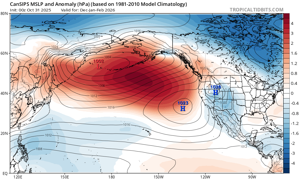
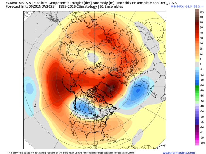
Thanks, been looking for failure modes. If this strong -IOD collapses in the next 1-2 mo and we end up with this kind of DJF pattern in the NPac, both of those are typically Nino harbingers:
-

Overnight Wednesday, November 5, 2025 Wind Event
weatherwiz replied to weatherwiz's topic in New England
I am really curious to see what moves through this evening (this would be fore Mass though and far northeast CT) in terms of a low topped line. There are some subtle hints at some very weak instability along/just ahead of the line as 500mb temperatures quickly cool and lapse rates steepen. -
We have had that multiple times and still failed. We had them in a Nina and a Nino. The Pac is really King. Many great mets were humbled when the pattern screamed HECS and nothing happened, not even a SECS. However, lets get the cold first and see what happens.
-
With snow cover in the foothills and higher elevations, most models(not the GFS) have temps 25 to almost 40 degrees below normal on those days.
-
The Euro is a bit deeper with this. The GFS deterministic is still further north but trending south. Interestingly, the GEFS lockstep with the Euro. Either way, this is a quick cold shot which means business. If the winter remembers what happens in November, we should see this reoccur.
-

Overnight Wednesday, November 5, 2025 Wind Event
WinterWolf replied to weatherwiz's topic in New England
Actually getting pretty breezy now here.. -
Made it to 68
-
No I'm not close the blinds like in a "dumpster fire" kind of way. Just more in a not expecting something different from what we've seen in a decade kind of way. Like basically the max for this setup (and winter) is advisory-level scenery snow--which is still nice to look at, mind you. I would just love to see a -AO/-NAO pattern in a more favorable regime to finally break the snow drought.
-

November 2025 general discussions and probable topic derailings ...
dryslot replied to Typhoon Tip's topic in New England
WCSH6 and WGME13? -
The 12z Euro is leading the way on this 9-10th system. I can't say that gives me a lot of comfort as I have grown to trust the GFS in handling systems a bit better over the SE. I would guess this might amp up as we get closer and IF the system continues to create this type of energy in the lee of the Apps.
-

Central PA Fall Discussions and Obs
Itstrainingtime replied to ChescoWx's topic in Upstate New York/Pennsylvania
Here is the full MU Winter Forecast: https://www.millersville.edu/weathercenter/forecasts/winter_outlook_2026.php -
 Not sure if we watch the same channels we get two news channels from Portland.
 -
It's not impossible to snow in a nina and a -pdo. I don't understand your thinking of "close the blinds" till we get a Nino. Is it harder? Sure but definitely not impossible and all weak ninas arent complete duds. I wouldn't expect a big storm this year but it doesn't have to be a complete dumpster fire also.
-
November 2025 general discussions and probable topic derailings ...
dryslot replied to Typhoon Tip's topic in New England
Yeah, Good to get an early start even if its gone in a few days. -
Local mets are saying same thing.
-
Oh if only it weren't a nina and a -PDO! These looks are useless...er, right?
-
Pictures indicate that one engine tore out its innards and fell off the wing before the actual crash.
-
I like that the trough is centered further west than the Lakes because it "should" open up the Gulf and Atlantic for overrunning while remaining cold enough for many for snow/frozen chances. If the trough was over the Lakes, it's cold/dry city outside that LES beneficiaries.
- Today
-
Great video from Phillip Prince on the destruction seen around where the eyewall came on shore. This focuses mostly on the geography/geology angle and how that affected things but I figured many in here would find it interesting.