All Activity
- Past hour
-
Wanna to bet?

-

Mid-Long Range Discussion 2026
WinstonSalemArlington replied to BooneWX's topic in Southeastern States
Wednesday Morning, June Chill -
those aren't scalar anomaly ranges ... They're probabilities for being above(below) at all... scaled.
-
I saw a dead cub at exit 8 on 89 this morning.
-

2026-2027 Strong/Super El Nino
GaWx replied to Stormchaserchuck1's topic in Weather Forecasting and Discussion
Nino 3.4 was unchanged at +0.5 in yesterday’s release. The other 3 regions warmed 0.1. I’m expecting 3.4 to be a few ticks warmer in the next weekly release as a typical delayed reaction to the start of the SOI drop a couple of weeks ago. 20MAY2026 1.6 0.7 0.5 0.6 27MAY2026 1.7 0.8 0.5 0.7 -
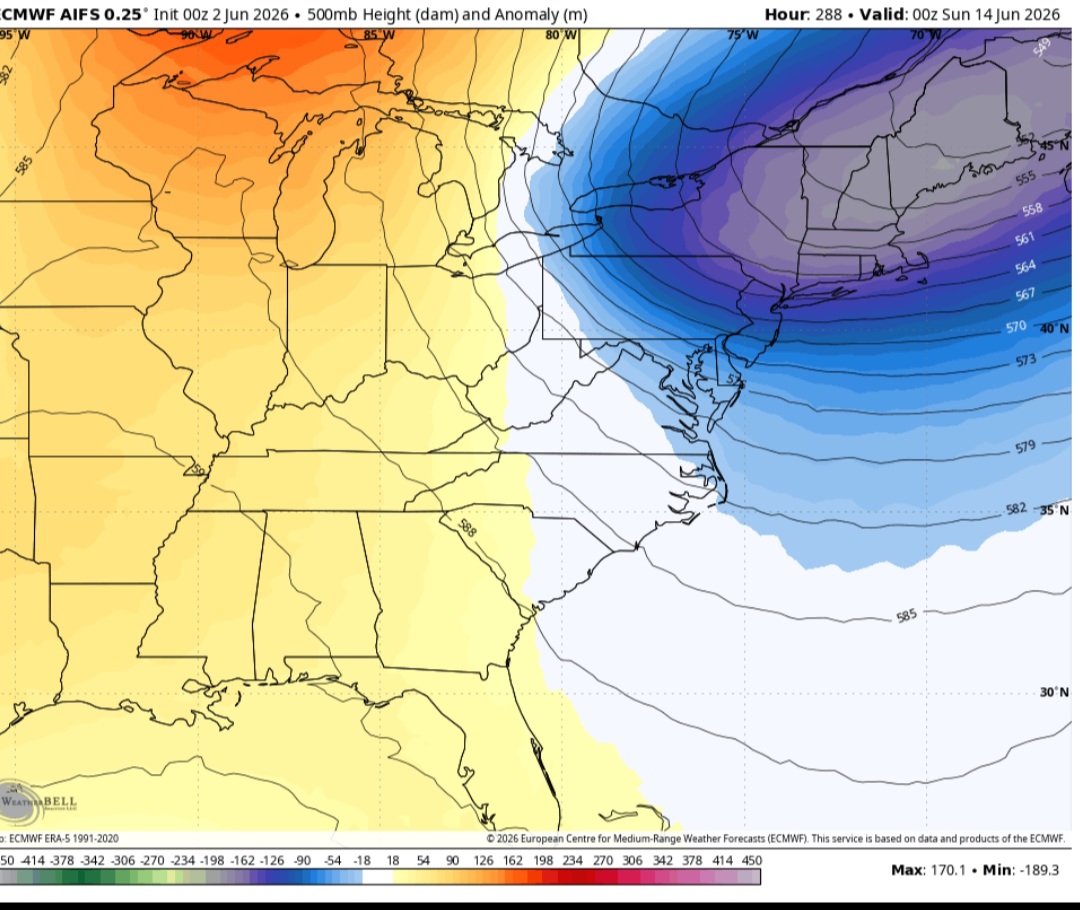
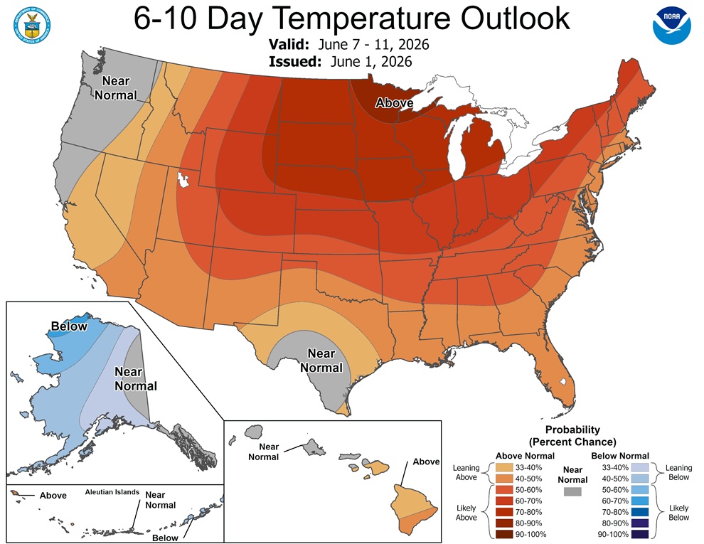
One thing I notice a lot is the CPC seems to overdo sfc temp anomalies. They see above avg 500 mb heights and just run w/ that. Well, we don't live at 18,000 ft. The 6-10 day outlook looks too warm for much of the E. The 500 ridge axis stays W of the Appalachians, so that promotes frontal passages often in NW flow, strong sfc highs either N/NW or over the area, and frequent sea breezes or synoptic onshore flow. Look at the GFSX MOS from Sunday on, that's below avg temps eastern sections of New England and near avg for western/inland sections at best.

-
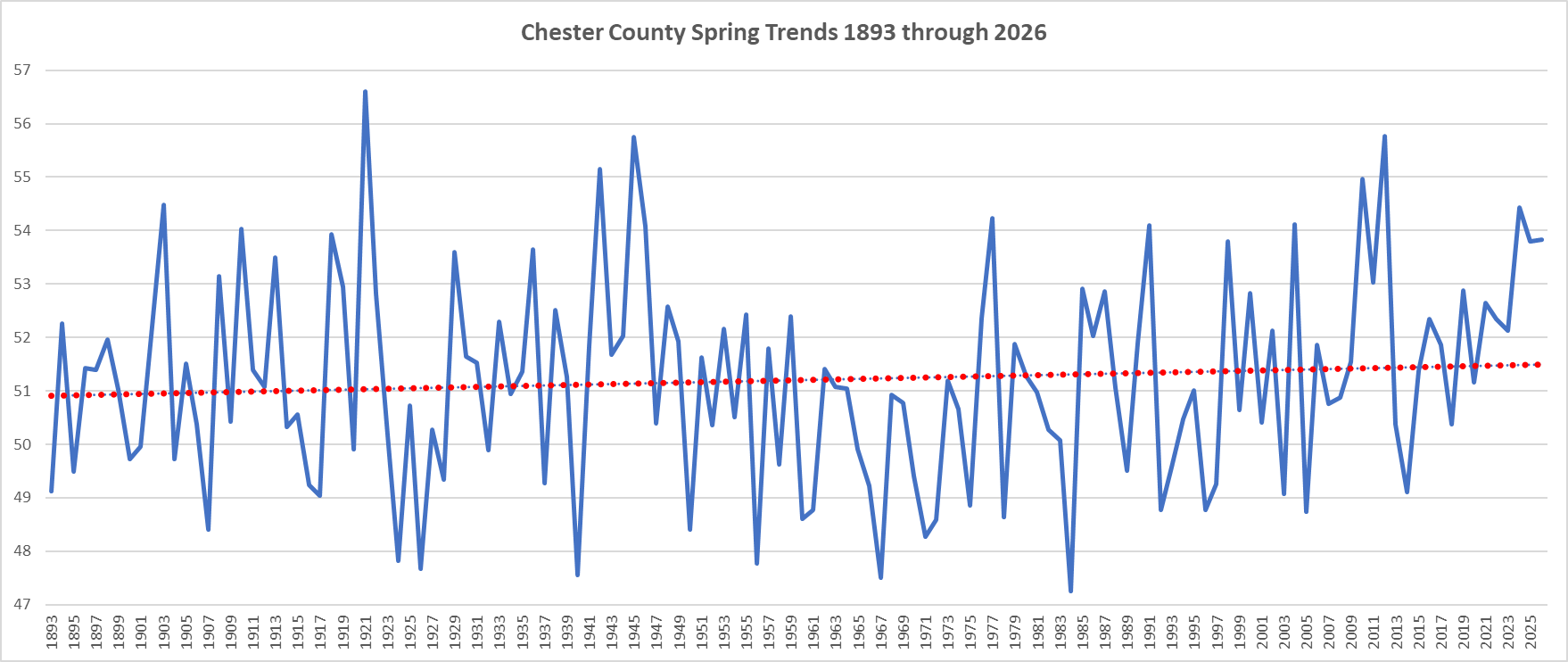
(002).thumb.png.6e3d9d46bca5fe41aab7a74871dd8af8.png) Of note Spring of 2026 was the 14th warmest Spring since 1893 - conversely Winter 2025-26 was our 14th coldest! Our weather does have a way of balancing out! Below is our Spring Temperature trends since 1893....only some slight warming evidenced by the data.
Of note Spring of 2026 was the 14th warmest Spring since 1893 - conversely Winter 2025-26 was our 14th coldest! Our weather does have a way of balancing out! Below is our Spring Temperature trends since 1893....only some slight warming evidenced by the data.
-
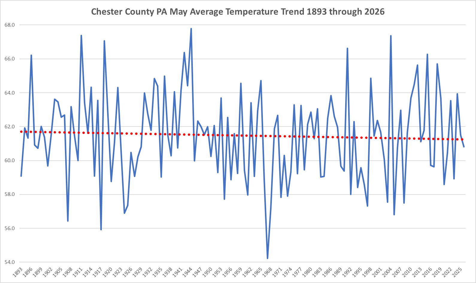
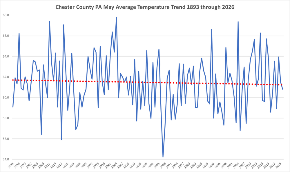
Since 1893 we have seen a cooling trend during the month of May here in Chester County PA
-
Looking ahead to 26/27 winter here is more evidence of a Modoki El Nino developing similar to 2009-2010 - time will tell...
-
Central PA Summer 2026 Discussion/Obs Thread
ChescoWx replied to Voyager's topic in Upstate New York/Pennsylvania
Of note here in the philly burbs of Chester County PA Spring of 2026 was the 14th warmest Spring since 1893 - conversely Winter 2025-26 was our 14th coldest! Our weather does have a way of balancing out! Below is our Spring Temperature trends since 1893....only some slight warming is shown.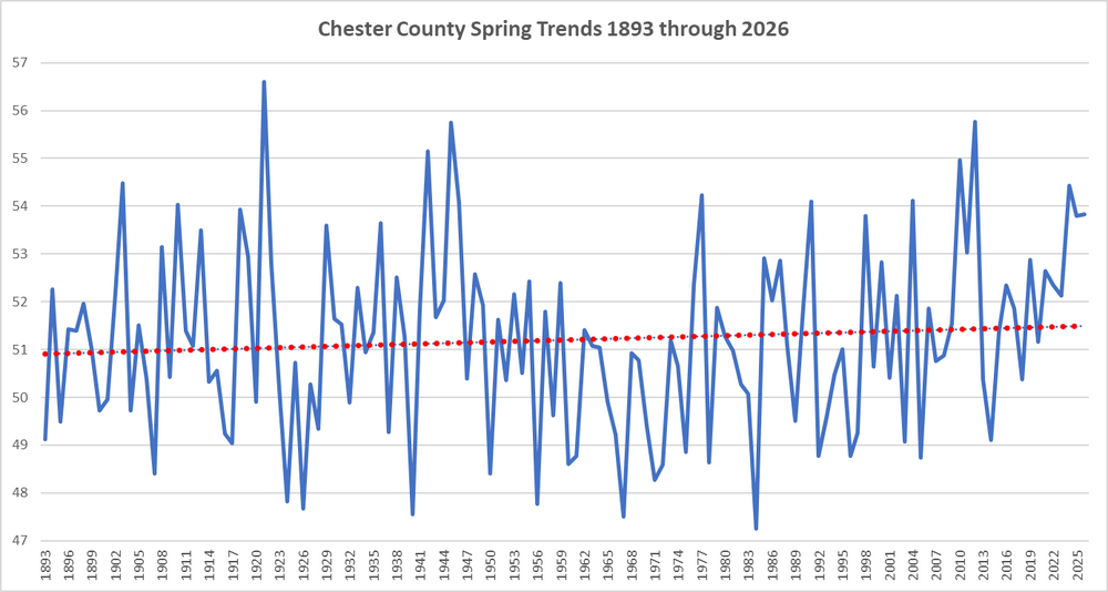
-
E PA/NJ/DE Spring 2026 Obs/Discussion
ChescoWx replied to PhiEaglesfan712's topic in Philadelphia Region
Of note here in the philly burbs of Chester County PA Spring of 2026 was the 14th warmest Spring since 1893 - conversely Winter 2025-26 was our 14th coldest! Our weather does have a way of balancing out! Below is our Spring Temperature trends since 1893....only some slight warming is shown.
-
hard to do that in winter
-
70.8/35 We need to pump those dews up
- Today
-

2026 Spring/Summer Mountain Thread
Maggie Valley Steve replied to Buckethead's topic in Southeastern States
I'm getting another round of showers this afternoon and 60 behind the cold front. We're going to need to clear out this afternoon if we have a chance at the upper 40s in the morning! -
Just large enough to be able to radiate and decouple from the ocean influence. They’re like their own little mesohigh on mornings like that. There must be a 360° landbreeze around the entire island. lol
-

2026-2027 Strong/Super El Nino
roardog replied to Stormchaserchuck1's topic in Weather Forecasting and Discussion
Yeah. All of that is going to happen plus fish will be living out of water and mosquitos will bite themselves. It’s going to be crazy!! -

2026-2027 Strong/Super El Nino
WX-PA replied to Stormchaserchuck1's topic in Weather Forecasting and Discussion
Cansips was good last winter where the CFS 2 had a torch, but yea every Super Nino is warm. We will have to wait to see how warm -
2026-2027 Strong/Super El Nino
WX-PA replied to Stormchaserchuck1's topic in Weather Forecasting and Discussion
So does that mean if it's 3.5 instead of 2.5 that we're going to melt?. Will Los Angeles fall into the ocean? Trying to figure the out the hype..Yes ithere will be above normal temps this winter, doesn't mean there won't be any winter weather. -
Straight up chilly today. Only 65
-

2026-2027 Strong/Super El Nino
Cobalt replied to Stormchaserchuck1's topic in Weather Forecasting and Discussion

-
Central PA Summer 2026 Discussion/Obs Thread
ChescoWx replied to Voyager's topic in Upstate New York/Pennsylvania
Since 1893 we have seen a cooling trend during the month of May
-
E PA/NJ/DE Spring 2026 Obs/Discussion
ChescoWx replied to PhiEaglesfan712's topic in Philadelphia Region
Since 1893 we have seen a cooling trend during the month of May
-
2026-2027 Strong/Super El Nino
WX-PA replied to Stormchaserchuck1's topic in Weather Forecasting and Discussion
72-73 also had some near misses to. -
I drove by that airport one night several years ago. It definitely is a cold spot. Very noticeable when going by as we had the windows down.
-

2026-2027 Strong/Super El Nino
mitchnick replied to Stormchaserchuck1's topic in Weather Forecasting and Discussion
Who cares