All Activity
- Past hour
-

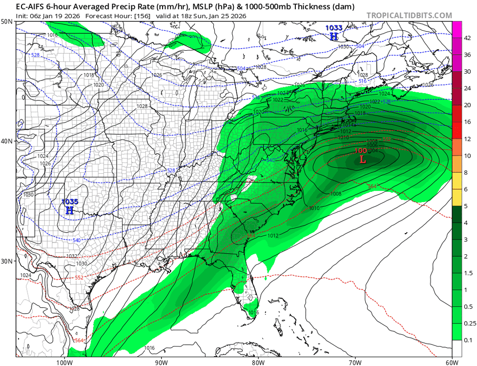
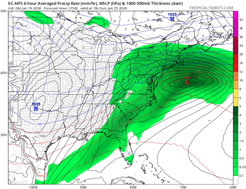
January 2026 regional war/obs/disco thread
SouthCoastMA replied to Baroclinic Zone's topic in New England
True, I was kinda worried to see that trend south..but I do trust the EUROAI more. -

Possible Record Breaking Cold + Snow 1/25 - 1/26
Jersey_Snowhole replied to TriPol's topic in New York City Metro
Yes I agree those temps will bring high ratios -
We need the first phase to be nearly perfect with next to no southern energy left behind for a HECS. For 6z this looked like a good consensus but now with 12z shifting the other way I agree its time to put those talks on hold till we see which way it goes at 18z and 0z.
-

January 2026 regional war/obs/disco thread
CoastalWx replied to Baroclinic Zone's topic in New England
Redevelops like the euro had with all that backside energy. -

January 2026 regional war/obs/disco thread
ORH_wxman replied to Baroclinic Zone's topic in New England
Euro suite slowed down overnight which definitely helped getting the storm north. I think that’s definitely what we want, a bit slower evolution that still gets plenty of northern stream involved…but that delay will allow the TPV to lift northeast and ease some of the confluence over us. -

Possible Record Breaking Cold + Snow 1/25 - 1/26
donsutherland1 replied to TriPol's topic in New York City Metro
It's significant, but notably lighter than the 0z solution. -
-
Gotcha, thanks!
-

January 2026 regional war/obs/disco thread
Spanks45 replied to Baroclinic Zone's topic in New England
CMC is kind of like PD 2003 storm, just lighter and a bit south.....a stronger southern system pushing a bit north would help a ton. Watching the radar loop from 2003, you can almost imagine that is what it would look like if the CMC run were to play out as is today at 12z -

January 25/26 Jimbo Back Surgery Storm
neverSnowsLCSC replied to Jimbo!'s topic in Southeastern States
Holy crap lol -
The Euro AI has been adjusting south too.
-
Looks like 13 on Kuchera.
-
January 2026 regional war/obs/disco thread
SouthCoastMA replied to Baroclinic Zone's topic in New England
Boom @ 150 with a 2ndary forming -

Possible Record Breaking Cold + Snow 1/25 - 1/26
Jt17 replied to TriPol's topic in New York City Metro
If there was ever a time to consider Kuchera it's with a storm like this. Gives the area almost a foot. . -

Possible Record Breaking Cold + Snow 1/25 - 1/26
MJO812 replied to TriPol's topic in New York City Metro
Yep a little less but a good hit -

January 25/26 Jimbo Back Surgery Storm
Brick Tamland replied to Jimbo!'s topic in Southeastern States
GFS starts the storm on Saturday and doesn't fully clear the SC and GA coast until Wednesday. -
Man the Eastern shore gets pounded this run of the CMC.
-

January 25/26 Jimbo Back Surgery Storm
NorthHillsWx replied to Jimbo!'s topic in Southeastern States
DC freakout commencing after that gfs run -

January 2026 regional war/obs/disco thread
ineedsnow replied to Baroclinic Zone's topic in New England
CMC looks great -

Possible Record Breaking Cold + Snow 1/25 - 1/26
SACRUS replied to TriPol's topic in New York City Metro
Total QPF (down from 00z but not much) -
And we love you too GGEM.
(12).thumb.png.e2c1e5e193d40961d001b27f4fbb1197.png)
-
Nah that happened with the +Bz on what could have been the aurora of the half century. Canadian still Quebec 1998s us. Euro isn't as destructive but still a lot of ice. GFS is now getting back into more ice. NWS has the 50/50 odds around I-40 which seems reasonable. Obviously, I'm praying hard for all snow. Yeah the forecast differences are with the two pieces of energy. Does the northern stream block or does the WAA punch through the line? (football metaphor)
-

January 25-26 Winter Storm Potential
The Iceman replied to Ralph Wiggum's topic in Philadelphia Region
Yeah this is why you don’t start threads 5 days out imo. Major negative changes on the gfs and cmc. Suppression is definitely on the table. -

January 25/26 Jimbo Back Surgery Storm
StantonParkHoya replied to Jimbo!'s topic in Southeastern States
Canadian trying for the Miller B transfer, but as has been mentioned, it's trended south hundreds of miles last three runs -
If the gfs was the only model showing a big snow at this range and other showed nothing would you think it was right? I’m still waiting on that blizzard it gave me last Thursday.

(002).thumb.png.6e3d9d46bca5fe41aab7a74871dd8af8.png)


(12).png.a200330c8070c62e2d3c7b4bbccc1598.png)

