Snow Eater Posted February 7, 2020 Share Posted February 7, 2020 Just got home from dinner at Hafners in N Syracuse. 32 here in Clay and nothing falling. Put salt on driveway just to make keep the ice away... Link to comment Share on other sites More sharing options...
wolfie09 Posted February 7, 2020 Share Posted February 7, 2020 Hrrr continues to improve.. Link to comment Share on other sites More sharing options...
Syrmax Posted February 7, 2020 Share Posted February 7, 2020 Jim Teske on WSYR 9 (who we like) at 6pm newscast had 4-8" for SyR and SE. 8-12" N&W, basically a SW/NE line thru CNY. Though...he said he is likely to move that line further SE to include SYR proper based on "new" modeling. I'm assuming that's the 12Z suite of models. Hard to argue with that. Link to comment Share on other sites More sharing options...
Thinksnow18 Posted February 7, 2020 Share Posted February 7, 2020 18 minutes ago, wolfie09 said: Hrrr continues to improve.. Improve for who??? 1 Link to comment Share on other sites More sharing options...
BuffaloWeather Posted February 7, 2020 Share Posted February 7, 2020 Some big time ice last few hours here. Even streets are completely glazed over. My ice brush broke trying to get through it, pretty thick. There needs to be a warning in place not an advisory. 3 Link to comment Share on other sites More sharing options...
PaulyFromPlattsburgh Posted February 7, 2020 Author Share Posted February 7, 2020 3 minutes ago, Thinksnow18 said: Improve for who??? Clearly for the northern Dacks. Western NY looks fringed 1 Link to comment Share on other sites More sharing options...
PaulyFromPlattsburgh Posted February 7, 2020 Author Share Posted February 7, 2020 1 minute ago, BuffaloWeather said: Some big time ice last few hours here. Even streets are completely glazed over. My ice brush broke trying to get through it, pretty thick. Same here where is your OBS from tonight? How was your trip to the Dacks? Link to comment Share on other sites More sharing options...
vortmax Posted February 7, 2020 Share Posted February 7, 2020 4 minutes ago, BuffaloWeather said: Some big time ice last few hours here. Even streets are completely glazed over. My ice brush broke trying to get through it, pretty thick. Looks like the radar is lighting up over BUF. Link to comment Share on other sites More sharing options...
wolfie09 Posted February 7, 2020 Share Posted February 7, 2020 7 minutes ago, Thinksnow18 said: Improve for who??? Looked better for all of us compared to some previous runs.. Take off about 1/2" or so for 10/1.. This is just till lunchtime tomorrow.. Link to comment Share on other sites More sharing options...
BuffaloWeather Posted February 7, 2020 Share Posted February 7, 2020 6 minutes ago, PaulyFromPlattsburgh said: Same here where is your OBS from tonight? How was your trip to the Dacks? I go feb 21-23. Link to comment Share on other sites More sharing options...
PaulyFromPlattsburgh Posted February 7, 2020 Author Share Posted February 7, 2020 New Burlington Nightly discussion !!!the forecast area remains unsaturated in the DGZ with the exception of far northern New York and the St. Lawrence Valley. Thus, through 12Z Friday expect precip mainly in the form of snow north of a line from Star Lake to Plattsburgh, NY to Jay Peak, VT where accumulations of 4-8" is expected. Eastward and generally north of I-89 we`re looking at a mix of snow, sleet and freezing rain while southward precip will be mainly freezing rain/drizzle. Snowfall accumulations here will generally be light in the 1-3" range with a glaze of ice possible, and southward no snow but up to 2 tenths of an inch of ice is expected. Link to comment Share on other sites More sharing options...
Thinksnow18 Posted February 7, 2020 Share Posted February 7, 2020 8 minutes ago, wolfie09 said: Looked better for all of us compared to some previous runs.. Take off about 1/2" or so for 10/1.. This is just till lunchtime tomorrow.. I'm going with less than what's showing...moderate freezingvrain ATM and not much precip behind...last night overachiever...tonight underachieving Link to comment Share on other sites More sharing options...
PaulyFromPlattsburgh Posted February 7, 2020 Author Share Posted February 7, 2020 I don’t mind 4-8 inches before afternoon tommorow.thats what NWS is basically saying. I’m not sure if I buy it but we will see . Think less before than with more developing after 10-11am Link to comment Share on other sites More sharing options...
SouthBuffaloSteve Posted February 7, 2020 Share Posted February 7, 2020 Just not feeling that 6-8” call for us in far WNY tomorrow... 3 2 Link to comment Share on other sites More sharing options...
PaulyFromPlattsburgh Posted February 7, 2020 Author Share Posted February 7, 2020 As we progress into early Friday morning, expect the areal coverage/intensity of precip to increase, as deep moisture and better lift develops from a number of ingredients. The idea of expanding pops to 100% near the international border and spreading them into VT looks good, given the sharpening boundary and favorable jet dynamics. Guidance still indicating warm layer btwn 800 and 700mb of 2 to 3c, associated with brisk southwest flow, but this should quickly erode as strong dynamics and rapid cyclogenesis occurs during Friday morning, with mixed precip changing to snow from nw to se. Timing of how quickly the changeover occurs will play a huge role in the amount of snowfall on Friday, but crnt fcst of an additional 10 to 20 inches north and 2 to 8 south looks good. Link to comment Share on other sites More sharing options...
wolfie09 Posted February 7, 2020 Share Posted February 7, 2020 10 minutes ago, Thinksnow18 said: I'm going with less than what's showing...moderate freezingvrain ATM and not much precip behind...last night overachiever...tonight underachieving Take a look at Tennessee/Kentucky between midnight and 2am, if you don't see anything than worry lol Link to comment Share on other sites More sharing options...
PaulyFromPlattsburgh Posted February 7, 2020 Author Share Posted February 7, 2020 I’m actually quite worried about ice accretion before the switch to snow tonight for Plattsburgh . HRRR hunting at it well while RGEM and HRDPS colder Link to comment Share on other sites More sharing options...
lakeeffectkid383 Posted February 7, 2020 Share Posted February 7, 2020 25 minutes ago, BuffaloWeather said: Some big time ice last few hours here. Even streets are completely glazed over. My ice brush broke trying to get through it, pretty thick. There needs to be a warning in place not an advisory. Pretty significant glazing of ice here too. Now we’re absolutely pounding sleet. Heaviest sleet I’ve ever seen in my life. Went out to move the cars around and the sleet literally hurt my face is was coming down so hard. 1 Link to comment Share on other sites More sharing options...
CNY_WX Posted February 7, 2020 Share Posted February 7, 2020 10 minutes ago, WesterlyWx said: Pretty significant glazing of ice here too. Now we’re absolutely pounding sleet. Heaviest sleet I’ve ever seen in my life. Went out to move the cars around and the sleet literally hurt my face is was coming down so hard. Hopefully the sleet means the column is starting to cool. It’s snowing across the lake in Toronto. 1 Link to comment Share on other sites More sharing options...
wolfie09 Posted February 7, 2020 Share Posted February 7, 2020 Down to 28°, starting to get some drizzle/Fz drizzle.. Link to comment Share on other sites More sharing options...
Snowstorms Posted February 7, 2020 Share Posted February 7, 2020 13 minutes ago, CNY_WX said: Hopefully the sleet means the column is starting to cool. It’s snowing across the lake in Toronto. I can confirm it's snowing lol. The column will cool once the storm begins to deepen so it'll likely transition over to snow soon for you guys. Link to comment Share on other sites More sharing options...
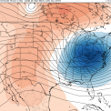
wolfie09 Posted February 7, 2020 Share Posted February 7, 2020 0z hrrr 1 Link to comment Share on other sites More sharing options...
DeltaT13 Posted February 7, 2020 Share Posted February 7, 2020 57 minutes ago, PaulyFromPlattsburgh said: Same here where is your OBS from tonight? How was your trip to the Dacks? I just got back from a week up there. I had made a post last night with some nice pics but I can’t seem to find it anywhere. It must have gotten lost in the internet ether. Conditions at Whiteface were pretty damn good considering the winter we’ve had. It was extremely painful to leave today with 15-20 inches knocking on their door 1 1 Link to comment Share on other sites More sharing options...
CNY-LES FREAK Posted February 7, 2020 Share Posted February 7, 2020 Down to 30F with a quickness but up above around H850 is where the warn tongue lies but should get beat down pretty quickly I'm hoping but if this H850LP was just 75 miles to our East we'd be in a very sweet spot. The saving grace is that theres no precip, lol!Sent from my SM-G970U using Tapatalk 1 Link to comment Share on other sites More sharing options...
PaulyFromPlattsburgh Posted February 7, 2020 Author Share Posted February 7, 2020 7 minutes ago, wolfie09 said: 0z hrrr Beautiful! Thank you 1 Link to comment Share on other sites More sharing options...
PaulyFromPlattsburgh Posted February 7, 2020 Author Share Posted February 7, 2020 2 minutes ago, DeltaT13 said: I just got back from a week up there. I had made a post last night with some nice pics but I can’t seem to find it anywhere. It must have gotten lost in the internet ether. Conditions at Whiteface were pretty damn good considering the winter we’ve had. It was extremely painful to leave today with 15-20 inches knocking on their door I can imagine. I would make up an excuse to stay until it’s done lol. Link to comment Share on other sites More sharing options...
CNY_WX Posted February 7, 2020 Share Posted February 7, 2020 Channel 9’s updated forecast. It includes the city of Syracuse in the 8-12 area. Link to comment Share on other sites More sharing options...
lakeeffectkid383 Posted February 7, 2020 Share Posted February 7, 2020 I’m gonna go out on a limb and say KBUF sees less than 4” for the rest of the event. Nothing other than a gut feeling. Link to comment Share on other sites More sharing options...
CNY_WX Posted February 7, 2020 Share Posted February 7, 2020 It flipped from ZR to IP to SN within 20 minutes in Niagara Falls around 7:30. Buffalo must be getting close. 1 Link to comment Share on other sites More sharing options...
Geez150 Posted February 7, 2020 Share Posted February 7, 2020 Straight rain here in North Livingston County, disappointed for sure... Link to comment Share on other sites More sharing options...

Recommended Posts
Create an account or sign in to comment
You need to be a member in order to leave a comment
Create an account
Sign up for a new account in our community. It's easy!
Register a new accountSign in
Already have an account? Sign in here.
Sign In Now