WxWatcher007
-
Posts
35,736 -
Joined
-
Last visited
Content Type
Profiles
Blogs
Forums
American Weather
Media Demo
Store
Gallery
Everything posted by WxWatcher007
-
It looks like for the first time in nearly a decade we won’t have a preseason storm in May. That said, the NHC has designated an area in the Gulf with a lemon for 10/20% odds of development. Environment looks marginal at best with high shear and dry air nearby, but the last two cycles of the Euro have been fairly bullish. More than usual for weak TC or STC genesis. Worth a casual eye, especially if convection can consistently fire enough to spawn a surface low.
-

May obs/discussion thread - Welcome to Severe Season!!
WxWatcher007 replied to weatherwiz's topic in New England
Have you started drinking 40s again? -
That’s crazy.
-
May obs/discussion thread - Welcome to Severe Season!!
WxWatcher007 replied to weatherwiz's topic in New England
The smoke from at least one fire shows up incredibly clear on GOES-E. The video here is incredible. -
The 2023 Lawn, Garden, Landscape Party Discussion
WxWatcher007 replied to Damage In Tolland's topic in New England
Got some good work in yesterday. Maybe I should consider converting some of the backyard into a real garden. The soil would probably be great for something with the moist soil. -
When will (did) you install/ turn on the AC this year?
WxWatcher007 replied to Cold Miser's topic in New England
It’s about that time. -
May obs/discussion thread - Welcome to Severe Season!!
WxWatcher007 replied to weatherwiz's topic in New England
-
May obs/discussion thread - Welcome to Severe Season!!
WxWatcher007 replied to weatherwiz's topic in New England
Fantastic day. Fantastic weekend. High of 82.8 here today. -
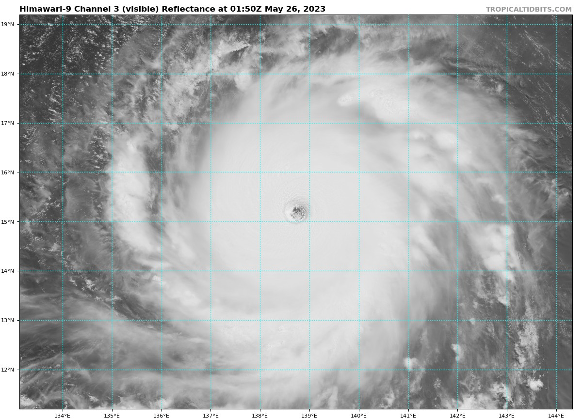
185mph/897mb
-
May obs/discussion thread - Welcome to Severe Season!!
WxWatcher007 replied to weatherwiz's topic in New England
That’s it. The high and mod days where the risk is relatively confined geographically is where you probably get the most convergence. I’ve gone out twice and while I wasn’t lucky enough to get the high end wedges lol I’ve gone to plenty of under the radar setups and gotten good stuff with not a lot of folks around. Edit: and also, like my early tropical chases, the practice is worth it in itself for me. -
The 2023 Lawn, Garden, Landscape Party Discussion
WxWatcher007 replied to Damage In Tolland's topic in New England
Thanks. Unfortunately, my neighbor could have used this advice. -
May obs/discussion thread - Welcome to Severe Season!!
WxWatcher007 replied to weatherwiz's topic in New England
It’s absolutely worth it. 100%. You’re well enough versed in tracking and identifying severe to go to places that won’t have as much chaser convergence. -
YES!!! Congratulations!!!
-
Man, I don’t usually follow WPAC stuff, but Mawar is extraordinary.
-
Going to be hard to top this globally for 2023. That’s just about perfection for a tropical cyclone.
-
The 2023 Lawn, Garden, Landscape Party Discussion
WxWatcher007 replied to Damage In Tolland's topic in New England
What do you guys do to get an anemometer/camera on your roof? Who do you call for that? lol -
May obs/discussion thread - Welcome to Severe Season!!
WxWatcher007 replied to weatherwiz's topic in New England
Boring spring so far -
-
15/6/2
-
It’s been incredibly hazy up here too. To me it’s almost a cloudy day. I miss blue sky.
-
This system is a great example of why recon is so important. Radar went down and left forecasters with limited ground observation and IR data just as the center collapsed some, making center fixes more difficult. Far from an ideal situation.
-
There’s a lemon on the potential low along the southeast coast, but it looks to remain non-tropical.
-
Rapid clearing of the eye now that it’s passing Guam.
-
Kind of hard to tell from the now out of operation radar, but I don’t think this has collapsed that much given the IR presentation. Obviously not high end 4 but it’s at least a high end 3 I believe especially in the southern part. The track is the bigger issue IMO. Now the northern and western part of Guam is in the surge zone.