donsutherland1
-
Posts
23,988 -
Joined
Content Type
Profiles
Blogs
Forums
American Weather
Media Demo
Store
Gallery
Everything posted by donsutherland1
-
A strong NAO blocking regime is in place and will persist into early November. As a result, an extended period of cooler than normal weather will prevail through the end of the month. Tomorrow will be a bit milder as temperatures rise into the upper 50s or lower 60s. Rain will arrive late tonight or early tomorrow. A general 1"-3" rainfall is likely late Wednesday night through Friday. There remains some uncertainty about the area of heaviest rainfall. The storm will be followed by a continuation of cool weather. In the long-range, the guidance suggests that an AO+/NAO+ regime could develop the first week in November. As has often happened with the loss of strong blocking, a milder regime could develop late in the first week of November or shortly afterward. The ENSO Region 1+2 anomaly was +0.3°C and the Region 3.4 anomaly was -0.6°C for the week centered around October 22. For the past six weeks, the ENSO Region 1+2 anomaly has averaged -0.07°C and the ENSO Region 3.4 anomaly has averaged -0.48°C. La Niña conditions will likely continue through mid-winter. The SOI was +18.18 today. The preliminary Arctic Oscillation (AO) was -0.392 today. The NAO was -1.634. Based on sensitivity analysis applied to the latest guidance, there is an implied 85% probability that New York City will have a warmer than normal October (1991-2020 normal). October will likely finish with a mean temperature near 58.3° (0.4° above normal). Supplemental Information: The projected mean would be 1.4° above the 1981-2010 normal monthly value.
-
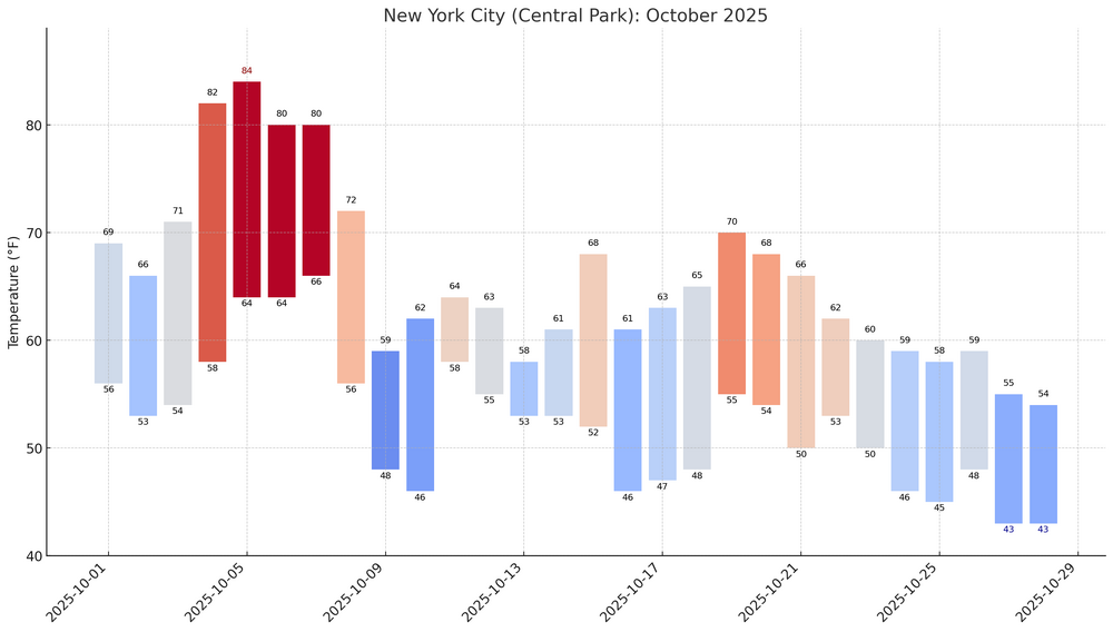
This is a perennial debate with multiple perspectives and no single solution. For longer-term climate perspectives, 1951-1980 (GISS) or 1901-2000 (NOAA) are good baselines. Those baselines allow one to compare the contemporary climate to a longstanding baseline for purposes of assessing how the climate has changed. The current 30-year figures reflect the current state of the climate, which is warmer than it was when assessed against the longer-term baselines typically used in climate research. The current figures also address the question visitors to locations might ask e.g., "What is it typically like in December in New York City?" That could be important for a visitor from Toronto who wants to know whether she really needs a sweater to view the lighting of the Rockefeller Center Christmas tree. Although the headline monthly anomaly, which will be slightly positive is typically used to define the monthly outcome, a better picture involves getting into more detail. The month will wind up with 58%-61% of days having been cooler than the 1991-2020 baseline. Moreover, the average anomaly was skewed by October 5-7, all of which averaged 10.5° or more above normal. Excluding those days, the monthly anomaly would be reduced by 1.3°. A trimmed mean, which would drop the three coldest and warmest days relative to normal would still result in a mean that would be 0.6° cooler. Here's how October looks through October 28th:
-
Major Hurricane Melissa - 892mb - 185mph Jamaica landfall
donsutherland1 replied to GaWx's topic in Tropical Headquarters
Yes, they have clearance. -
A strong NAO blocking regime is in place and will persist into early November. As a result, an extended period of cooler than normal weather will prevail through the end of the month. Tomorrow will be another cool day. Temperatures will top out in the lower and middle 50s across much of the region. The unseasonably cool weather will continue through at least the middle of the week before it turns a bit milder. Rain will likely arrive Wednesday night or Thursday. A general 1"-3" rainfall is likely late Wednesday night through Friday. There remains uncertainty about the area of heaviest rainfall. The storm will be followed by a continuation of cool weather. The ENSO Region 1+2 anomaly was +0.3°C and the Region 3.4 anomaly was -0.6°C for the week centered around October 22. For the past six weeks, the ENSO Region 1+2 anomaly has averaged -0.07°C and the ENSO Region 3.4 anomaly has averaged -0.48°C. La Niña conditions will likely continue through mid-winter. The SOI was +23.46 today. The preliminary Arctic Oscillation (AO) was +0.455 today. The NAO was -1.744. That is the lowest NAO figure since November 22, 2024 when the NAO was -1.823. Based on sensitivity analysis applied to the latest guidance, there is an implied 78% probability that New York City will have a warmer than normal October (1991-2020 normal). October will likely finish with a mean temperature near 58.3° (0.4° above normal). Supplemental Information: The projected mean would be 1.4° above the 1981-2010 normal monthly value.
-
The preliminary global mean temperature for October 26 was 14.99°C. That would easily surpass the existing mark of 14.93°C from 2024. To date, 329/366 (89.9%) of daily records have been set or tied in 2023, 2024, and 2025. The oldest surviving records were set on December 9-10, 2015. The ERA-5 dataset goes back to 1940.
-
A strong NAO blocking regime is in place and will persist into early November. As a result, an extended period of cooler than normal weather will prevail through the end of the month. Tomorrow will be another cool day. Temperatures will top out in the lower and middle 50s across much of the region. Many locations outside of New York City will again see readings start in the 30s. Hard freezes are again likely well north and west of New York City. The unseasonably cool weather will continue through at least the middle of the week. Rain will likely arrive Wednesday night or Thursday. A general 1"-3" rainfall is likely late Wednesday night through Friday. There remains uncertainty about the area of heaviest rainfall. The storm will be followed by a continuation of cool weather. The ENSO Region 1+2 anomaly was +0.3°C and the Region 3.4 anomaly was -0.6°C for the week centered around October 22. For the past six weeks, the ENSO Region 1+2 anomaly has averaged -0.07°C and the ENSO Region 3.4 anomaly has averaged -0.48°C. La Niña conditions will likely continue through mid-winter. The SOI was +23.33 today. The preliminary Arctic Oscillation (AO) was +1.351 today. The NAO was -1.497. Based on sensitivity analysis applied to the latest guidance, there is an implied 70% probability that New York City will have a warmer than normal October (1991-2020 normal). October will likely finish with a mean temperature near 58.2° (0.3° above normal). Supplemental Information: The projected mean would be 1.3° above the 1981-2010 normal monthly value.
-
Correlation of extreme hurricanes, AGW, and solar cycles
donsutherland1 replied to WolfStock1's topic in Climate Change
All basins. -
Major Hurricane Melissa - 892mb - 185mph Jamaica landfall
donsutherland1 replied to GaWx's topic in Tropical Headquarters
Thanks for sharing the link. The paper's explanation is more nuanced than the broader language to which I responded and it covers all basins, not just the Atlantic. Its abstract is sufficient and states: ...extreme TC events with a maximum wind speed of 137 knots and higher (category 5) are most likely to occur during the declining phase of a solar cycle and least likely to occur during the ascending phase or the maximum phase. Although solar activity levels are similar during the declining and ascending phases, the yearly occurrence rate is nearly double in the declining phase (1.123) as compared to that in the ascending phase (0.625). -
Major Hurricane Melissa - 892mb - 185mph Jamaica landfall
donsutherland1 replied to GaWx's topic in Tropical Headquarters
Solar maximum years include 1958, 1968, 1979, 1989, 2001, 2014, 2024 (or 2025). Beulah (1967), Camille (1969), David (1979), Allen (1980), Gilbert (1988), Hugo (1989), Beryl (2024) and Milton (2024) occurred within a year of the solar maximum or during the solar maximum. -
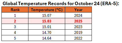
The preliminary October 25 value of 15.03°C breaks the record of 15.01°C that was set just last year. It also ties last year's value for the latest 15°C or above mean temperature on record.
-
2025-2026 ENSO
donsutherland1 replied to 40/70 Benchmark's topic in Weather Forecasting and Discussion
I believe his analog mix provides further illustration of the subjective nature of choosing analogs. There is no one "right way" to do so. He places a lot of weight on the QBO. The selection of 2014-15 suggests that the QBO outweighed other variables such as ENSO. Others use different considerations. Can analogs be constructed objectively with consistently reasonable performance? I don't know. That's part of the reason I am trying an ENSO-Teleconnections approach based on RMSE and will weigh its outcome against my own winter thoughts (to be posted mid-November). If there is promise, I'll re-run the exercise for spring and summer. -
A strong NAO blocking regime is in place and will persist into early November. As a result, an extended period of cooler than normal weather will prevail through the end of the month. Tomorrow will be another cool day. Temperatures will top out in the lower and middle 50s across much of the region. Many locations outside of New York City will see readings start in the 30s. Hard freezes are likely well north and west of New York City. The unseasonably cool weather will continue through at least the middle of the week. Rain could arrive Wednesday night or Thursday. A general 1"-3" rainfall is likely late Wednesday night through Friday. There remains uncertainty about the area of heaviest rainfall. The storm will be followed by a continuation of cool weather. The ENSO Region 1+2 anomaly was -0.4°C and the Region 3.4 anomaly was -0.6°C for the week centered around October 15. For the past six weeks, the ENSO Region 1+2 anomaly has averaged -0.15°C and the ENSO Region 3.4 anomaly has averaged -0.47°C. La Niña conditions will likely continue through mid-winter. The SOI was +30.36 today. That is the first +30.00 or above figure since April 2, 2025 when the SOI reached +35.40. The preliminary Arctic Oscillation (AO) was +1.370 today. Meanwhile the NAO was -1.329. That last time the NAO was -1.000 or below and the AO was +1.000 or above was March 2, 2023. The last time it happened during fall was November 4-5, 2021. Based on sensitivity analysis applied to the latest guidance, there is an implied 51% probability that New York City will have a warmer than normal October (1991-2020 normal). October will likely finish with a mean temperature near 58.0° (0.1° above normal). Supplemental Information: The projected mean would be 1.1° above the 1981-2010 normal monthly value.
-
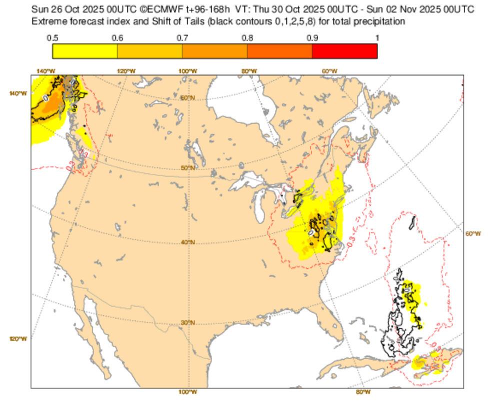
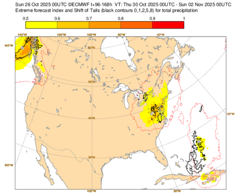
The idea of a significant rainfall across the New York City area remains on track. The latest EFI shows the spatial area of significant rains. Based on the overall guidance, noting that there is some uncertainty about the placement of the heaviest rains, a general 1"-3" multi-day rain event appears likely.
-
2025-2026 ENSO
donsutherland1 replied to 40/70 Benchmark's topic in Weather Forecasting and Discussion
Earlier this month, it was noted that based on objective ENSO-Teleconnections analysis, 2021-2022 was an emerging, high-ranked analog. Today, the NAO was -1.329 while the AO was +1.370. The last time the NAO was -1.000 or below while the AO was +1.000 or above during fall was November 4-5, 2021. -
2025-2026 ENSO
donsutherland1 replied to 40/70 Benchmark's topic in Weather Forecasting and Discussion
Here's a link: www.jamstec.go.jp/virtualearth/general/en/graph_SINTEX.html#emi -
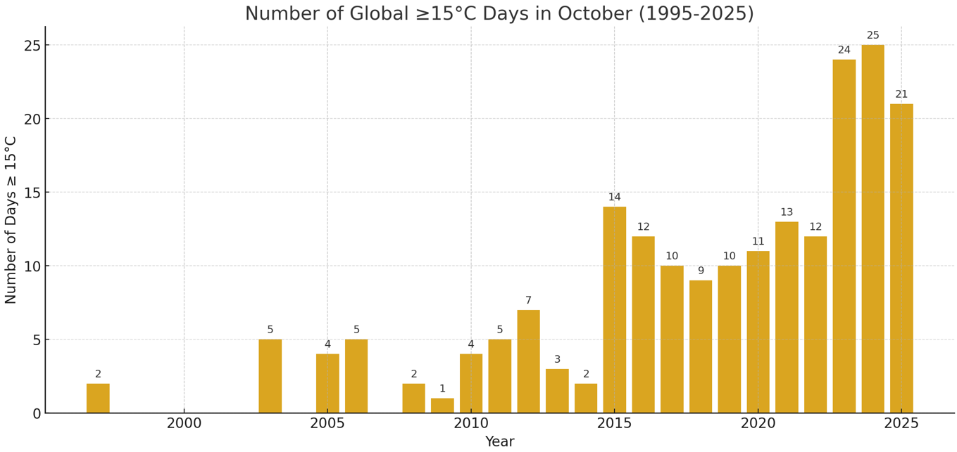
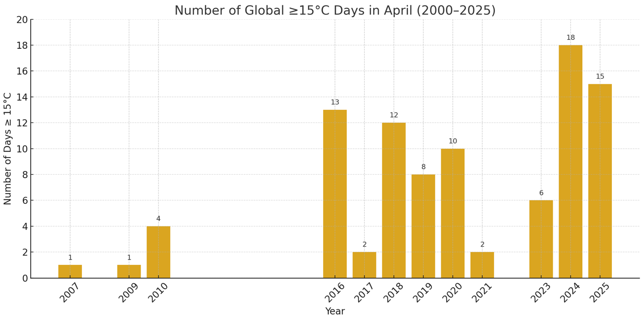
Despite ongoing La Niña conditions, global temperatures on October 24th were the second highest on record. Nothing has come close to the last three years. October 2025 is currently the third warmest October on record globally. 2015 was the first year that saw the last 15.00°C or above day occur on October 10 or later. Since 2015, all but one year has seen a last 15.00° or above temperature on or after October 10. The single exception was 2018 when the last such day occurred on October 9th. Prior to 1997, there were no such cases in October. 15.00°C days have now become a common occurrence in October. Such days have begun to occur earlier, as well. In 2007, April had its first 15.00°C or above day (April 30). Now, their first appearance in April has become a fairly regular occurrence. The record was set in 2024 when the first such day occurred on April 13. In 2025, the first such day was April 14.


-
A strong NAO blocking regime is in place and will persist into early November. As a result, an extended period of cooler than normal weather will prevail through the end of the month. Tomorrow will be another cool day. Temperatures will top out in the lower and middle 50s across much of the region. The unseasonably cool weather will continue into at least the middle of next week. Rain could arrive Wednesday night or Thursday. A significant rainfall is possible through Friday. The ENSO Region 1+2 anomaly was -0.4°C and the Region 3.4 anomaly was -0.6°C for the week centered around October 15. For the past six weeks, the ENSO Region 1+2 anomaly has averaged -0.15°C and the ENSO Region 3.4 anomaly has averaged -0.47°C. La Niña conditions will likely continue through mid-winter. The SOI was +24.62 today. The preliminary Arctic Oscillation (AO) was +0.187 today. Based on sensitivity analysis applied to the latest guidance, there is an implied 50% probability that New York City will have a cooler than normal October (1991-2020 normal). October will likely finish with a mean temperature near 57.9° (near normal). Supplemental Information: The projected mean would be 1.0° above the 1981-2010 normal monthly value.
-
Yes. Consistent with what would expect from the strong NAO block. Select Mean Temperature Data for October 22-31, 1980-2024: NAO -2.000 to -1.000: 51.0° All Other Cases: 55.0° 1980-2024 Mean: 54.3° If we can get such blocking regimes during winter, things will likely be quite a bit different in terms of snowfall from the last several paltry winters.
-
With regard to the latest literature on Siberian snow cover, that would tend to be the case when snow cover is above normal during the fall.
-
-
The GFS and GGEM have moved into good agreement about the potential for a significant or perhaps even major rain event for the closing days of October. Rainfall for the 48-Hour Period Ending 10/31 12z for NYC: 10/24 18z GFS: 0.0" 10/25 0z GFS: 0.0" 10/25 6z GFS: 1.5" 10/25 12z GFS: 4.7" 10/25 0z GGEM: 0.5" 10/25 12z GGEM: 4.3" While the excessive amounts are far from certain, the general idea of a potentially widespread significant or greater rainfall is the key takeaway. The kind of powerful block in place under which a trough is trapped can lead to some big precipitation events.
-
I appreciate that some are trying AI. AI is here to stay and learning how to use it effectively is important. AI is already adding value to tasks, and it will almost certainly add even more value to tasks in the future. One should be familiar what it can and cannot do, recognize that it can and does make errors. Results should be verified by human examination of key results. Using multiple AIs to address the same prompt can also provide insight. If they provide a consistent outcome, one can have greater confidence in the generated outcome. If there are differences, that's often a sign that one or both have errors. One should also know how to write effective prompts. When writing a prompt one should be focused on obtaining objective high-quality results. Such prompts are similar to an exploratory research question where one seeks to understand something while being careful to avoid influencing the results. Prompt injection (and bullying) assures that one gets bad results. Such prompts are typically written to confirm biases. AIs can break down under such tactics.
-
An AO-/NAO-/PNA+ blocking regime is in place. As a result, an extended period of cooler than normal weather will prevail through the end of the month. It will turn somewhat cooler this weekend. Temperatures will reach the lower and middle 50s. The unseasonably cool weather will continue into at least the middle of next week. There is a possibility that the closing days of October into the opening days of November could experience a significant multi-day rain event. The ENSO Region 1+2 anomaly was -0.4°C and the Region 3.4 anomaly was -0.6°C for the week centered around October 15. For the past six weeks, the ENSO Region 1+2 anomaly has averaged -0.15°C and the ENSO Region 3.4 anomaly has averaged -0.47°C. La Niña conditions will likely continue through mid-winter. The SOI was +24.43 today. The preliminary Arctic Oscillation (AO) was -0.566 today. Based on sensitivity analysis applied to the latest guidance, there is an implied 53% probability that New York City will have a cooler than normal October (1991-2020 normal). October will likely finish with a mean temperature near 57.8° (0.1° below normal). Supplemental Information: The projected mean would be 0.9° above the 1981-2010 normal monthly value.
-
2025-2026 ENSO
donsutherland1 replied to 40/70 Benchmark's topic in Weather Forecasting and Discussion
As some people seem to think it's not a big issue that they made incorrect claims, here's the AMO for the 2025 through September for all to see. 2025 1 0.98 2025 2 0.86 2025 3 0.75 2025 4 0.67 2025 5 0.73 2025 6 0.78 2025 7 0.87 2025 8 0.86 2025 9 0.76 What those who dismiss the dissemination of bad claims don't understand is that there is a big difference between forecasting (no one has a crystal ball) and making incorrect claims about objective verifiable data. Just because most of the social media readers might not ever seek to verify the claims and many may have no idea where the data resides, does not make such claims appropriate. If anything, because those pushing the false claims no that such claims won't be challenged, it makes such claims particularly unethical. Tragically, as anyone can play "meteorologist" on social media without any accountability, there's a lot of bad information being pushed into the public space. Yet, unless meteorologists speak out against such practices, the profession winds up being tarnished by the public perceptions created by misleading data, unfulfilled hype, etc. -
2025-2026 ENSO
donsutherland1 replied to 40/70 Benchmark's topic in Weather Forecasting and Discussion
This again reflects a big issue with social media. It’s a “Wild West” where anyone can play meteorologist, put out forecasts, and make claims about data. Verification is non-existent. Links to the data aren’t provided. Hype gains attention. Credible sources are drowned out.