donsutherland1
-
Posts
23,988 -
Joined
Content Type
Profiles
Blogs
Forums
American Weather
Media Demo
Store
Gallery
Everything posted by donsutherland1
-
Winter 2025-2026 Thoughts
donsutherland1 replied to donsutherland1's topic in Weather Forecasting and Discussion
It could. That's the wild card so to speak. 2017-18 is in the analog mix. It saw 7.7" snow in December and 40.9" overall. 2016-17 had 3.2" in December and 30.2" overall. -
2025-2026 ENSO
donsutherland1 replied to 40/70 Benchmark's topic in Weather Forecasting and Discussion
When it comes to sudden stratospheric warming events (SSWEs) or major stratospheric warming events (MSWEs), these events can be a response to strong blocking (bottom-up), which often reinforces and extends the blocking. They can also be top-down events that lead to a downward-propagating tropospheric response. Typically, there is approximately a 10-20-day lag, where the NAO/AO move toward and into a negative state. This blocking can then persist for 30 days and longer, with some fluctuations. Tropospheric responses to vortex-splitting events are often stronger than those for displacement events. However, more often than not, the larger portion of the split vortex winds up in Eurasia and the smaller one moves into North America. So, if the sudden or major stratospheric warming event occurs in the closing days of this month, its impact on North America would probably start to be seen near mid-December +/- few days. Right now, a major event with a wind reversal isn't assured.
-
2025-2026 ENSO
donsutherland1 replied to 40/70 Benchmark's topic in Weather Forecasting and Discussion
I agree. Hopefully, CPC will start using RONI as its official measure. In any case, the relationship holds true with ONI or RONI. -
2025-2026 ENSO
donsutherland1 replied to 40/70 Benchmark's topic in Weather Forecasting and Discussion
For another illustration of the importance of the PNA for parts of the East, the EPS is forecasting a WPO-/EPO-/AO-/PNA- pattern for the first 10 days of December. Setting aside skill issue at that range, here's how things have fared 1980-2024 when the only difference was a PNA- vs. a PNA+. I used NYC, but the same applies broadly to the Middle Atlantic Region.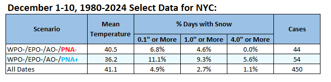
-
Tomorrow through Friday will see highs mainly in the upper 40s to lower 50s. Another brief push of cold air could arrive to start the weekend. Overall, temperatures will likely remain generally below normal through Saturday. Sunday could turn briefly milder before another cool air mass moves into the region. Some showers are possible on Sunday. The ENSO Region 1+2 anomaly was -0.2°C and the Region 3.4 anomaly was -0.7°C for the week centered around November 5. For the past six weeks, the ENSO Region 1+2 anomaly has averaged -0.07°C and the ENSO Region 3.4 anomaly has averaged -0.55°C. La Niña conditions will likely continue through at least mid-winter. The SOI was -7.13 today. The preliminary Arctic Oscillation (AO) was -1.861 today. Based on sensitivity analysis applied to the latest guidance, there is an implied 57% probability that New York City will have a cooler than normal November (1991-2020 normal). November will likely finish with a mean temperature near 47.4° (0.6° below normal). Supplemental Information: The projected mean would be 0.3° below the 1981-2010 normal monthly value.
-
Occasional Thoughts on Climate Change
donsutherland1 replied to donsutherland1's topic in Climate Change
COP30 is on track to become yet another farce in the process to address climate change. Its agenda contains no items on mitigation. It contains no discussion of a phase-out of fossil fuels. At the same time, it punts the discussion of the Paris climate goal and progress toward that goal to COP31. It is yet another ratification of a status quo that is the primary driver of climate change.
-
2025-2026 ENSO
donsutherland1 replied to 40/70 Benchmark's topic in Weather Forecasting and Discussion
It does seem to become skillful within a week of the following month. -
2025-2026 ENSO
donsutherland1 replied to 40/70 Benchmark's topic in Weather Forecasting and Discussion
Here's the data for December vs. January-April snowfall for New York City for La Niña winters 1979-80 through 2024-2025. 2024-2025 is officially listed as cold neutral. December 2024 had 2.8" of snow.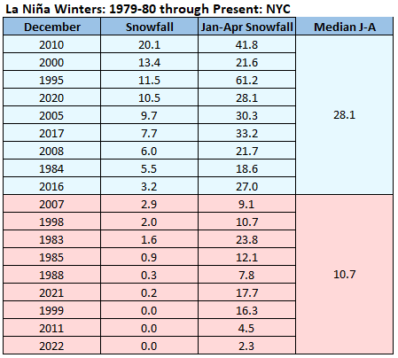
-
2025-2026 ENSO
donsutherland1 replied to 40/70 Benchmark's topic in Weather Forecasting and Discussion
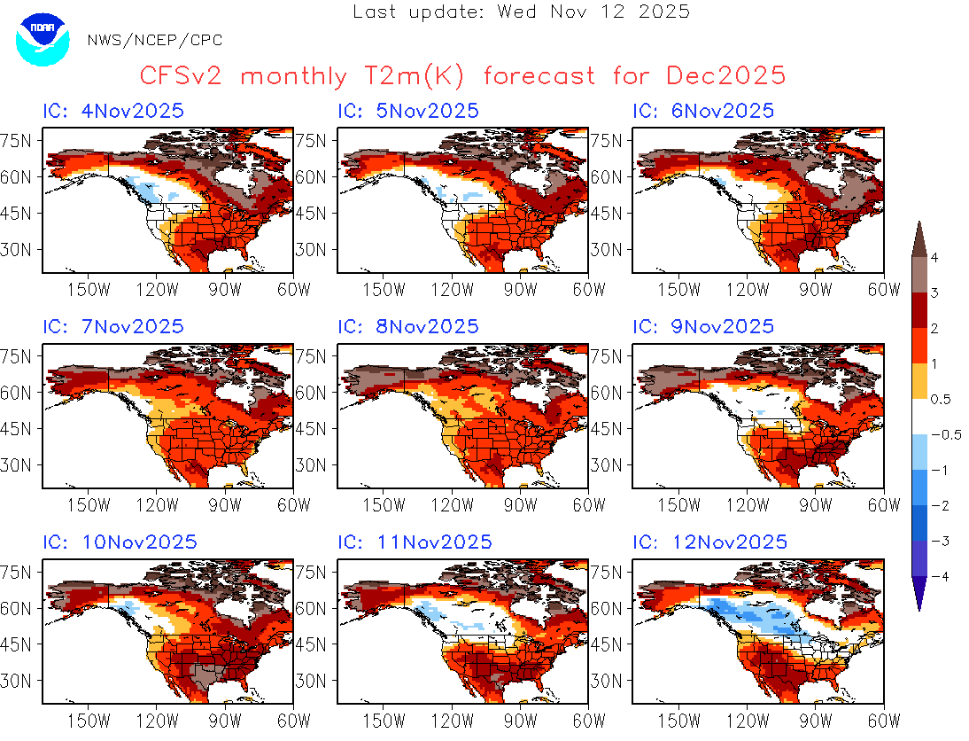
Here's the evolution of the CFSv2 forecast for December. It should be noted that all the timeframes, the CFSv2 is not yet in its high skill area.
-
2025-2026 ENSO
donsutherland1 replied to 40/70 Benchmark's topic in Weather Forecasting and Discussion
For Washington, DC to New York City, a PNA+ is far more common for days with 6" or more snowfall except during the second half of February and afterward when the wave lengths shorten. New York City statistics since 1950: For January, when wave lengths are at their longest, a PNA+ was present for 92.5% of days with 6" or more snowfall in New York City. For Boston, the PNA+ plays a smaller role.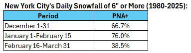
-
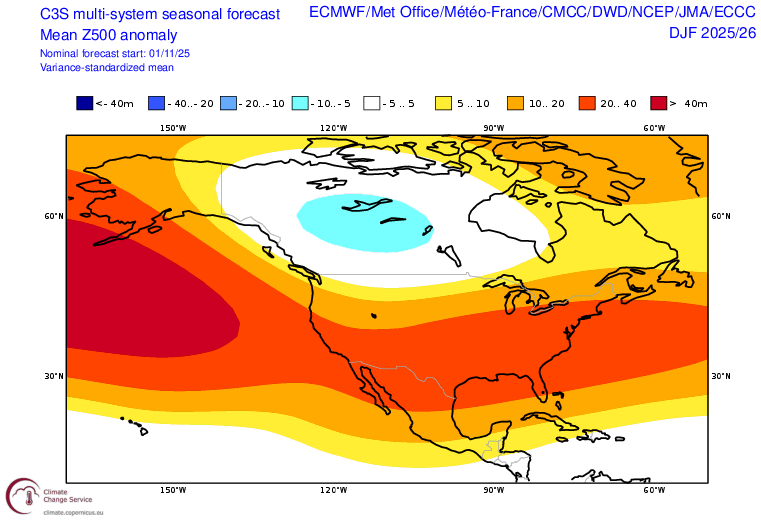
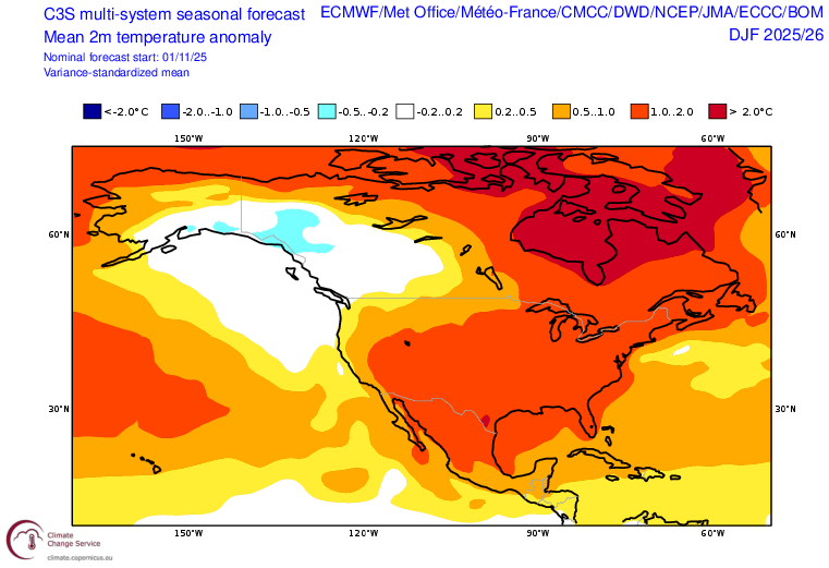
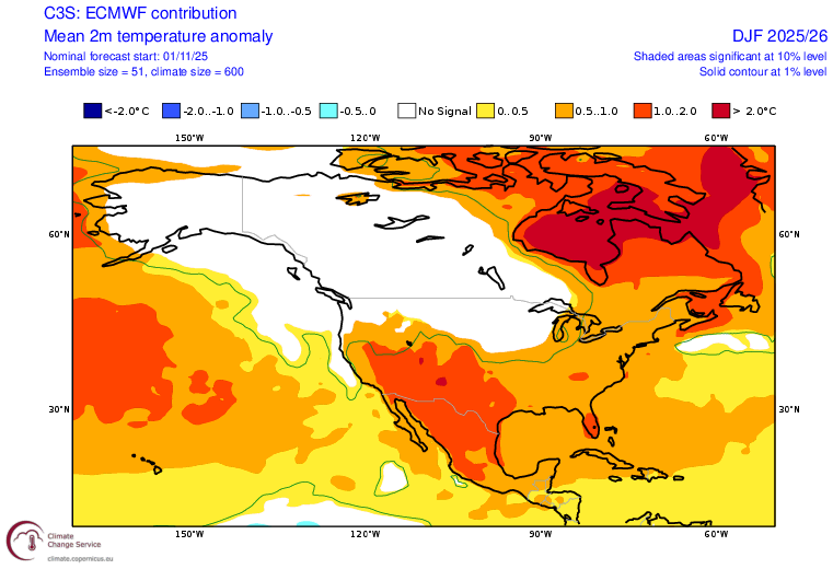
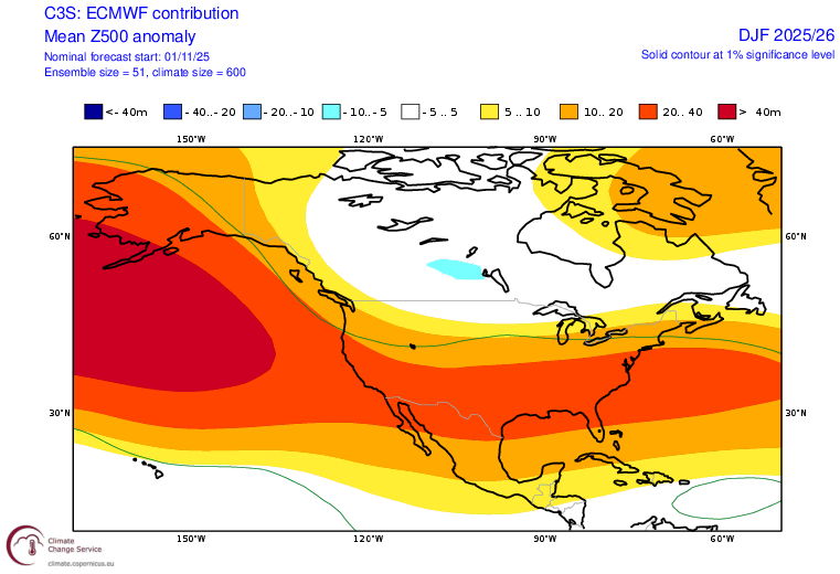
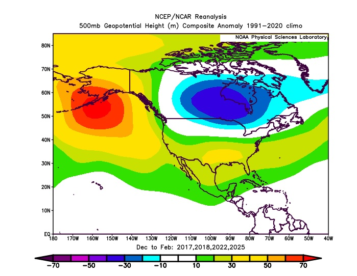
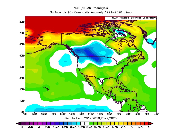
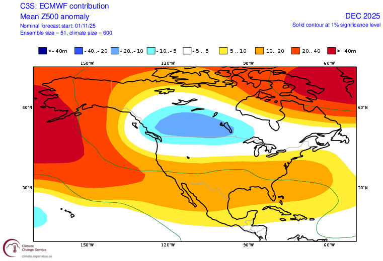
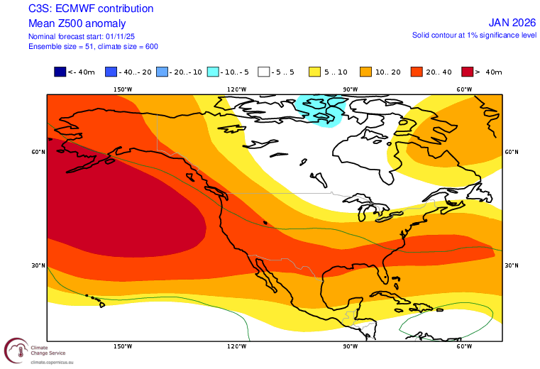
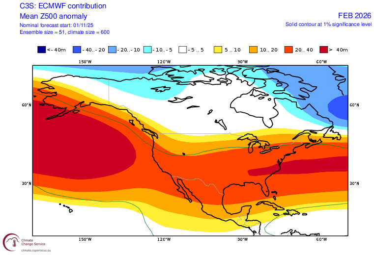
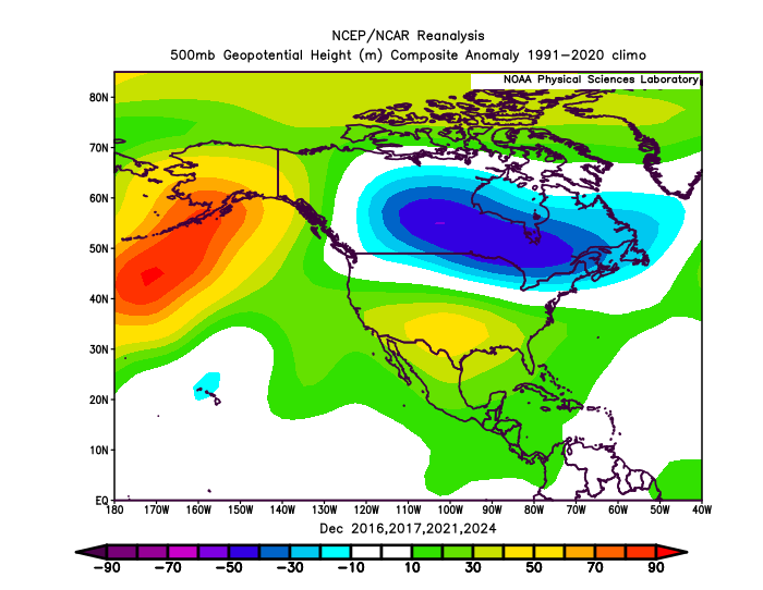
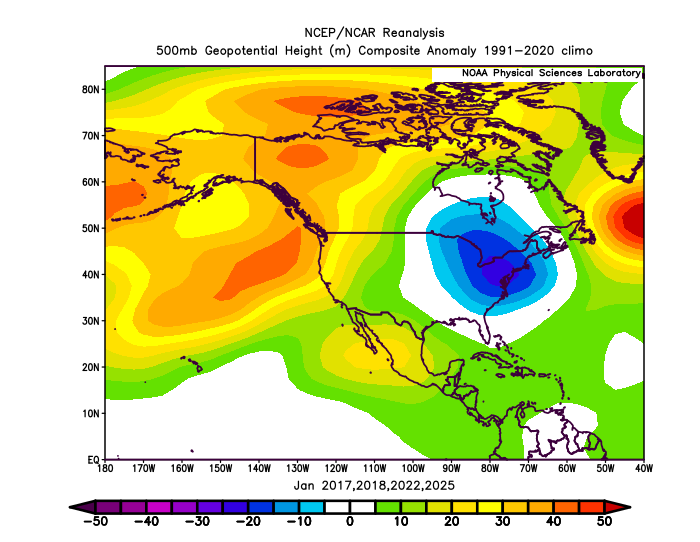
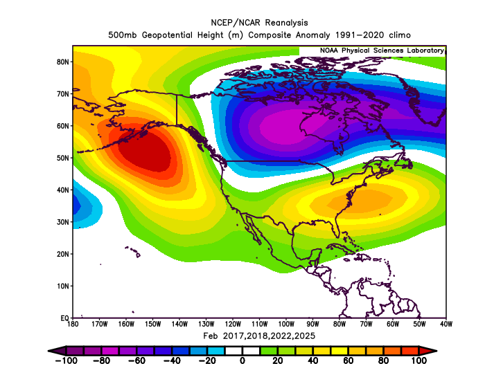
A classic La Niña winter appears to be on the way. There will likely be some interesting developments, along the way, particularly if a sudden stratospheric warming event materializes in late November or early December. Then, the potential would exist for a cold end to December and possibly first half of January, if the polar vortex is displaced. Based on ENSO and the teleconnections, there is a signal for the coldest month relative to normal to be January in the Gulf Coast and Southeast. Perhaps the Arctic outbreak of November 10-11 that saw the coldest anomalies affect the Southeast offers a hint of how things might unfold in January. The C3S multi-model system appears to be quite aggressive with above normal temperatures. Last winter, there were some indications that it was too aggressive with the warmth, but I deferred to the guidance. That proved to be a bad mistake leading to an overly warm idea. This time, I am giving more weight to the analog cases for insight. The ECMWF seasonal forecast appears to be a better fit with the final cases I selected based on ENSO and the teleconnections. My selected comparison cases for Winter 2025-2026 are Winters 2016-2017, 2017-2018, 2021-2022, and 2024-2025. C3S Seasonal Forecasts: ECMWF: Analog Cases: ECMWF: December-February 500 mb Progression: Analog Cases: December-February 500 mb Progression: Select Snowfall Estimates: Albany: 45"-60" Baltimore: 10"-15" Binghamton: 80"-90" Boston: 35"-45" Buffalo: 85"-95" Burlington: 75"-85" Caribou: 110"-125" Chicago: 30"-40" Detroit: 40"-50" New York City: 15"-25" Newark: 15"-25" Philadelphia: 10"-20" St. Louis: 10"-15" Toronto: 100 cm - 125 cm Washington, DC: 8"-12"
- 15 replies
-
- 11
-

-

-
The coldest air mass this season will begin to depart from the region. It will turn somewhat milder tomorrow. Tomorrow through Friday will see highs mainly in the upper 40s to lower 50s. Another brief push of cold air could arrive to start the weekend. Overall, temperatures will likely remain generally below normal through Saturday. Sunday could turn briefly milder before another cool air mass moves into the region. The ENSO Region 1+2 anomaly was -0.2°C and the Region 3.4 anomaly was -0.7°C for the week centered around November 5. For the past six weeks, the ENSO Region 1+2 anomaly has averaged -0.07°C and the ENSO Region 3.4 anomaly has averaged -0.55°C. La Niña conditions will likely continue through at least mid-winter. The SOI was -1.85 today. The preliminary Arctic Oscillation (AO) was -0.867 today. Based on sensitivity analysis applied to the latest guidance, there is an implied 59% probability that New York City will have a cooler than normal November (1991-2020 normal). November will likely finish with a mean temperature near 47.3° (0.7° below normal). Supplemental Information: The projected mean would be 0.4° below the 1981-2010 normal monthly value.
-
2025-2026 ENSO
donsutherland1 replied to 40/70 Benchmark's topic in Weather Forecasting and Discussion
Jacksonville has experienced an earlier first freeze than New York City (Central Park) for only 12th time on record since winter 1871-1872. The last time that occurred was during winter 2016-2017 (Jacksonville: Nov 21; NYC: Dec 9), also a La Niña winter. -
I'm happy to learn that she's ok.
-
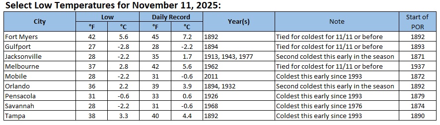
Some low temperatures from this morning:
-
Savannah saw the temperature dip to 28° this morning. That broke the daily record of 31° from 1968. It is also the coldest temperature so early in the season since November 9, 1976 when the mercury fell to 26°.
-
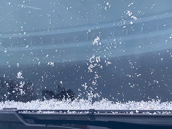
Some flurries and snow showers in Larchmont, NY.

-
This evening, the temperature fell into the 30s for the first time this season in New York City. Last year's first such reading occurred on November 13th. The 1991-2020 normal first such date is October 24th. The temperature will likely bottom out near freezing in New York City. The normal first freeze occurs on November 21st. Outside the City, widespread 20s are likely. Highs tomorrow will only reach the upper 30s and lower 40s. Parts of the region could see some snow flurries or even some snow showers. It will then turn somewhat milder. Wednesday through Friday will see highs mainly in the upper 40s to lower 50s. The ENSO Region 1+2 anomaly was -0.2°C and the Region 3.4 anomaly was -0.7°C for the week centered around November 5. For the past six weeks, the ENSO Region 1+2 anomaly has averaged -0.07°C and the ENSO Region 3.4 anomaly has averaged -0.55°C. La Niña conditions will likely continue through at least mid-winter. The SOI was +3.94 today. The preliminary Arctic Oscillation (AO) was -0.955 today. Based on sensitivity analysis applied to the latest guidance, there is an implied 57% probability that New York City will have a cooler than normal November (1991-2020 normal). November will likely finish with a mean temperature near 47.4° (0.6° below normal). Supplemental Information: The projected mean would be 0.3° below the 1981-2010 normal monthly value.
-
A storm brought snow from Chicago to Toronto earlier today. The stage is now set for a signifant to major lake effect snow event around Lake Michigan tonight into tomorrow. That storm will drag a strong cold front will across the region this evening and tonight bringing some showers and perhaps even a thunderstorm. Following its passage, an early taste of winter-like temperatures will be in store for a short time. As colder air drills into the region tomorrow, the temperature will fall through the lower 50s and through the 40s. A few rain showers are possible. Well north and west of New York City, some snow showers or snow flurries are possibe. Tuesday will be unseasonably cold. The temperature will rise from the lower 30s into just the lower 40s in New York City. Outside the City, widespread lows in the 20s are possible Tuesday morning. Wednesday through Friday will see highs mainly in the upper 40s to lower 50s. The Deep South could see the temperature fall to record low levels, particularly on Tuesday. Parts of Florida will likely see a freeze. The ENSO Region 1+2 anomaly was +0.1°C and the Region 3.4 anomaly was -0.6°C for the week centered around October 29. For the past six weeks, the ENSO Region 1+2 anomaly has averaged -0.05°C and the ENSO Region 3.4 anomaly has averaged -0.52°C. La Niña conditions will likely continue through mid-winter. The SOI was +7.95 today. The preliminary Arctic Oscillation (AO) was -1.495 today. Based on sensitivity analysis applied to the latest guidance, there is an implied 54% probability that New York City will have a cooler than normal November (1991-2020 normal). November will likely finish with a mean temperature near 47.6° (0.4° below normal). Supplemental Information: The projected mean would be 0.1° below the 1981-2010 normal monthly value.
-
11/8-11/10 First Snow and Lake Effect Event
donsutherland1 replied to Geoboy645's topic in Lakes/Ohio Valley
Very beautiful pictures. There is always beauty in the snow. -
11/8-11/10 First Snow and Lake Effect Event
donsutherland1 replied to Geoboy645's topic in Lakes/Ohio Valley
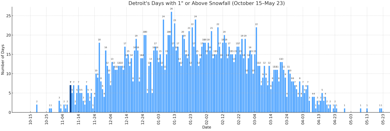
With 1.2" of snow earlier today, Detroit saw 1" or more snowfall for the 7th time on record for November 9. The prior cases for November 9 snowfall of 1" or above are: 1894 2.0" 1913 1.8" 1921 5.3" (daily record; 3rd biggest daily snowfall on record prior to November 15; 8th biggest daily snowfall on record for November) 1933 1.3" 1971 1.6" 2018 1.3" November 9 is the earliest date with 7 or more such snowfalls.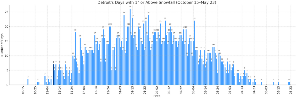
-
Congratulations on the new job.
-
11/8-11/10 First Snow and Lake Effect Event
donsutherland1 replied to Geoboy645's topic in Lakes/Ohio Valley
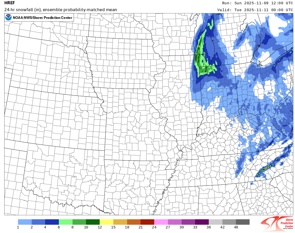
The 12z HREF:
-
The LES event will follow from the circulation of a synoptic event that brought snow from Chicago to Detroit and will deliver an appreciable/significant snowfall in Ottawa, Montreal and Quebec City.