donsutherland1
-
Posts
24,112 -
Joined
Content Type
Profiles
Blogs
Forums
American Weather
Media Demo
Store
Gallery
Everything posted by donsutherland1
-
Advancing smoke shield just after a cloudy sunrise.


-
Despite wildfire smoke, temperatures topped out well in the 90s across the region. Highs included: Atlantic City: 99° Bridgeport: 92° Islip: 92° New York City-Central Park: 95° New York City-JFK Airport: 98° New York City-LaGuardia Airport: 98° Newark: 98° Philadelphia: 98° Temperatures will soar into the upper 80s to perhaps lower 90s tomorrow. Smoke could hold down the readings by several degrees across parts of the region. Friday will also be very warm before the temperatures ease for the weekend. Showers and thundershowers are possible during the weekend. The greatest risk is Saturday night and Sunday. Highs will generally reach the lower and perhaps middle 80s through the middle of next week. The ENSO Region 1+2 anomaly was +3.4°C and the Region 3.4 anomaly was +1.8°C for the week centered around July 1. For the past six weeks, the ENSO Region 1+2 anomaly has averaged +2.80°C and the ENSO Region 3.4 anomaly has averaged +1.52°C. The ongoing strong El Niño will continue to strengthen through the summer. The SOI was -36.56 yesterday. The preliminary Arctic Oscillation (AO) was +0.104 today. Based on sensitivity analysis applied to the latest guidance, there is an implied near 65% probability that New York City will have a warmer than normal July (1991-2020 normal). July will likely finish with a mean temperature near 78.5° (1.0° above normal). Supplemental Information: The projected mean would be 2.0° above the 1981-2010 normal monthly value.
-
From a little earlier this afternoon:

-
Bronx:

-
One can smell the smoke in the Bronx, as well, even as it's not as thick as that in Rhinebeck.
-
Occasional Thoughts on Climate Change
donsutherland1 replied to donsutherland1's topic in Climate Change
Climate change is taking the United Kingdom into an entirely new and hotter climate. Airport runways, malfunctioning sensors, and urbanization have little to do with these changes. There are no asphalt tarmacs or dense urban metropolises in the offshore waters experiencing a growing number of marine heatwaves. Fossil fuel-driven greenhouse gas-induced warming is mainly responsible for these outcomes. The State of the UK Climate 2025 report and Met Office summary documents a country undergoing rapid and increasingly visible climatic change. 2025 was the warmest recorded year in the United Kingdom, while the decade from 2016 to 2025 was substantially warmer than previous reference periods. Record warmth was not confined to a single season: the UK experienced its warmest spring and summer, with every month from March through August ranking among the ten warmest on record. Extreme heat is also rising faster than average temperatures, bringing more days above 30°C (86°F) and more unusually warm nights, especially in southern and urban areas. The changes extend well beyond air temperature. Northwest European waters experienced an unprecedented number of marine-heatwave days, while sea level around the UK continued its accelerating rise. Rainfall patterns are becoming more uneven, with wetter winters, more frequent extremely wet months and the continuing threat of severe seasonal drought. Spring 2025 was England’s driest in more than a century, demonstrating that a warmer climate can intensify both flooding and water scarcity. Record sunshine and exceptionally low river flows further illustrated how several interconnected parts of the climate system are shifting at the same time. The report’s central conclusion is that the United Kingdom is no longer experiencing climate change primarily as a sequence of isolated records. It is entering a different climate regime. Conditions once regarded as exceptional, such as record heat, tropical nights, marine heatwaves, intense winter rainfall and prolonged dry spells, are becoming increasingly characteristic of the present climate. The greatest risks emerge not simply from gradual warming, but from the rapid intensification of extremes that place growing pressure on public health, water supplies, agriculture, infrastructure, ecosystems and coastal communities. The United Kingdom is not merely witnessing a temporary period of unusual weather. It is living through the consequences of a human-altered climate, with each new record serving as another chapter in a story whose ending will depend on how rapidly emissions are reduced. How rapidly emissions are reduced remains a matter of choice, and it's a choice with relatively well-known consequences drawn from a large body of scientific research. Meanwhile, 2026 is producing more hot extremes. For the first time on record, the UK has reached 35.0°C (95°F) in May, June, and July. -
Temperatures will soar into the 90s tomorrow and Thursday. The potential exists for a few locations, including Newark to approach or reach 100° at the height of the short period of heat tomorrow. Smoke could hold down the readings by several degrees. Friday will also be very warm before the temperatures ease for the weekend. Showers and thundershowers are possible during the weekend. The greatest risk is Saturday night and Sunday. The ENSO Region 1+2 anomaly was +3.4°C and the Region 3.4 anomaly was +1.8°C for the week centered around July 1. For the past six weeks, the ENSO Region 1+2 anomaly has averaged +2.80°C and the ENSO Region 3.4 anomaly has averaged +1.52°C. The ongoing strong El Niño will continue to strengthen through the summer. The SOI was -36.56 today. The preliminary Arctic Oscillation (AO) was -0.083 today. Based on sensitivity analysis applied to the latest guidance, there is an implied near 66% probability that New York City will have a warmer than normal July (1991-2020 normal). July will likely finish with a mean temperature near 78.7° (1.2° above normal). Supplemental Information: The projected mean would be 2.2° above the 1981-2010 normal monthly value.
-
A brief push of heat from an impressive heat dome over the Central and Northern Plains that sent the mercury to all-time records of 109° at Salt Lake City and 110° at Billings, MT could send temperatures into the 90s tomorrow through Thursday. The potential exists for Newark to approach 100° at the height of the short period of heat. Friday will also be very warm before the temperatures ease for the weekend. The ENSO Region 1+2 anomaly was +3.4°C and the Region 3.4 anomaly was +1.8°C for the week centered around July 1. For the past six weeks, the ENSO Region 1+2 anomaly has averaged +2.80°C and the ENSO Region 3.4 anomaly has averaged +1.52°C. The ongoing strong El Niño will continue to strengthen through the summer. The SOI was -38.53 today. The preliminary Arctic Oscillation (AO) was -0.360 today. Based on sensitivity analysis applied to the latest guidance, there is an implied near 63% probability that New York City will have a warmer than normal July (1991-2020 normal). July will likely finish with a mean temperature near 78.7° (1.2° above normal). Supplemental Information: The projected mean would be 2.2° above the 1981-2010 normal monthly value.
-
Temperatures will peak in the lower to middle 80s tomorrow before heat begins to push in from the Plains States. A brief push of heat from an impressive heat dome over the Central and Northern Plains that sent the mercury to all-time records of 109° at Salt Lake City and 110° at Billings, MT could send temperatures into the 90s during Tuesday through Thursday. The potential exists for Newark to approach 100° at the height of the short period of heat. Friday will also be very warm before the temperatures ease for the weekend. The ENSO Region 1+2 anomaly was +3.4°C and the Region 3.4 anomaly was +1.8°C for the week centered around July 1. For the past six weeks, the ENSO Region 1+2 anomaly has averaged +2.80°C and the ENSO Region 3.4 anomaly has averaged +1.52°C. The ongoing strong El Niño will continue to strengthen through the summer. The SOI was -38.53 today. The preliminary Arctic Oscillation (AO) was -0.478 today. Based on sensitivity analysis applied to the latest guidance, there is an implied near 63% probability that New York City will have a warmer than normal July (1991-2020 normal). July will likely finish with a mean temperature near 78.7° (1.2° above normal). Supplemental Information: The projected mean would be 2.2° above the 1981-2010 normal monthly value.
-
Tomorrow will again feature highs mainly in the lower 80s. Temperatures will remain in the lower to middle 80s on Monday before heat begins to push in from the Plains States. Some heat from an impressive heat dome over the Central and Northern Plains could send temperatures into the 90s near mid-month. The potential exists for Newark to approach 100° at the height of the short period of heat. The ENSO Region 1+2 anomaly was +3.4°C and the Region 3.4 anomaly was +1.8°C for the week centered around July 1. For the past six weeks, the ENSO Region 1+2 anomaly has averaged +2.80°C and the ENSO Region 3.4 anomaly has averaged +1.52°C. The ongoing El Niño will continue to strengthen through the summer. The SOI was -30.66 today. The preliminary Arctic Oscillation (AO) was -0.244 today. Based on sensitivity analysis applied to the latest guidance, there is an implied near 64% probability that New York City will have a warmer than normal July (1991-2020 normal). July will likely finish with a mean temperature near 78.8° (1.3° above normal). Supplemental Information: The projected mean would be 2.3° above the 1981-2010 normal monthly value.
-
Occasional Thoughts on Climate Change
donsutherland1 replied to donsutherland1's topic in Climate Change
The article doesn't really debunk the basis for concern about ongoing warming. In the U.S., the 1930s provided a glimpse of what aridification would be like from the combination of a series of exceptional droughts and poor agricultural practices. Now, with rising temperatures, the Dust Bowl Era extremes are gradually being replaced. Now, let's go to the article. If the climate were relatively stable, one should see a similar tendency with cold and hot extremes. At longer timeframes, one should also see both diminishing. Key excerpts from the article: Regarding Cold Extremes: The incidence of daily TMin records has declined in all regions with the lowest CONUS value of 5.3 occurring in 1998–2012 then ending in 2025 at only 7.9 per station per 15-yrs. This represents a drop of over half from the pre-1997 15-yr values. The relative coherence of the separate regions is also notable with very little variation from the CONUS average in the past 30 years... The event of Feb 1899 is clearly evident as the most extreme event for the CONUS but there are several in the 7–8 °F (~ 4 C) range up until the mid-1980s. From that point, extreme area-averaged cold has almost vanished as only three of the 29 years since 1996 achieved negative departures, all of which were relatively small. Regarding Hot Extremes: From the fewest daily records “centered” around 1970, all regions show some level of rise to the present. The most recent 15-year period for the CONUS experienced 21.1 daily TMax records, the most since 1936–1950, yet well below the highest of 35.1 in 1925–1939. Regarding Heat vs. Cold: The sum of days in extreme heat/cold declined from over 120 in the 1930s to about 75 since 1960. The conclusion here would be that the CONUS has experienced a decline of around 30% of these durative extreme events in the past 100 years. Along with this decline has been an increase in heatwave days vs. cold wave days since the 1970s, mainly due to the increase in heatwave days in the West (Fig. 10) and the decline in cold wave days overall. These differences are consistent with what one would expect from a warming climate, not a stable, much less cooling one. -
Occasional Thoughts on Climate Change
donsutherland1 replied to donsutherland1's topic in Climate Change
I strongly agree. This chart that purports to represent rural U.S. temperatures is badly flawed. I'm not surprised that there is no attribution or full inventory of stations and the years for which their data was used. However, upon further research, it seems to have originated at the Electroverse climate change denial site. The chart relies on a changing station sample, extreme geographic undercoverage (n=6) in the early period, and equal weighting of unevenly distributed stations. The combination of absolute temperature averaging and changing station composition is a fatal flaw. To illustrate the absurdity of the impact of a changing station mix. Let's say one had a mix of just Charleston and New Haven in 2025. The annual average mean for those two stations (not representative of the U.S., but that's a separate issue) would have been 60.6°. Now, if one added Casper into the mix, the new three-station average would fall sharply to 56.2°. Simply adding or removing stations has an artificial impact on the temperature average. This chart elevates the art of "cherrypicking" to new heights. -
Occasional Thoughts on Climate Change
donsutherland1 replied to donsutherland1's topic in Climate Change
The chart implies that the mix of stations is different depending on the year. Changing mix, alone, means one is not consistently calculating the same mean across time. -
Some parts of the region could see a shower or thundershower this evening or overnight. The weekend will turn somewhat cooler with highs mainly in the lower 80s. Temperatures will remain in the lower to middle 80s on Monday before heat begins to push in from the Plains States. Some heat from an impressive heat dome over the Central and Northern Plains could send temperatures into the 90s near mid-month. The potential exists for Newark to approach 100° at the height of the short period of heat. The ENSO Region 1+2 anomaly was +3.4°C and the Region 3.4 anomaly was +1.8°C for the week centered around July 1. For the past six weeks, the ENSO Region 1+2 anomaly has averaged +2.80°C and the ENSO Region 3.4 anomaly has averaged +1.52°C. The ongoing El Niño will continue to strengthen through the summer. The SOI was -19.94 today. The preliminary Arctic Oscillation (AO) was +0.262 today. Based on sensitivity analysis applied to the latest guidance, there is an implied near 65% probability that New York City will have a warmer than normal July (1991-2020 normal). July will likely finish with a mean temperature near 78.9° (1.4° above normal). Supplemental Information: The projected mean would be 2.4° above the 1981-2010 normal monthly value.
-
2026-2027 Super El Nino
donsutherland1 replied to Stormchaserchuck1's topic in Weather Forecasting and Discussion
And the WMO validated it in December 2021. https://wmo.int/media/news/wmo-recognizes-new-arctic-temperature-record-of-380c -
Some additional showers and thundershowers are possible early tonight. A few could bring heavy downpours. Tomorrow will feature high temperatures in the upper 80s. A few of the hot spots could approach or reach 90°. Showers or thundershowers are again possible. The weekend will turn somewhat cooler with highs mainly in the lower 80s. No excessive heat appears likely through mid-month. However, some of the guidance has grown hotter near mid-month so that situation will bear watching. The ENSO Region 1+2 anomaly was +3.4°C and the Region 3.4 anomaly was +1.8°C for the week centered around July 1. For the past six weeks, the ENSO Region 1+2 anomaly has averaged +2.80°C and the ENSO Region 3.4 anomaly has averaged +1.52°C. The ongoing El Niño will continue to strengthen through the summer. The SOI is not available due to data feed issues. This could be an extended issue. The preliminary Arctic Oscillation (AO) was +0.814 today. Based on sensitivity analysis applied to the latest guidance, there is an implied near 65% probability that New York City will have a warmer than normal July (1991-2020 normal). July will likely finish with a mean temperature near 78.9° (1.4° above normal). Supplemental Information: The projected mean would be 2.4° above the 1981-2010 normal monthly value.
-
Tomorrow will feature high temperatures in the lower to perhaps middle 80s and the Friday could see highs in the upper 80s. A few of the hot spots could approach or reach 90°. Showers or thundershowers are possible on both days. The weekend will turn somewhat cooler with highs mainly in the lower 80s. No excessive heat appears likely through mid-month. However, some of the guidance has grown hotter near mid-month so that situation will bear watching. The ENSO Region 1+2 anomaly was +3.4°C and the Region 3.4 anomaly was +1.8°C for the week centered around July 1. For the past six weeks, the ENSO Region 1+2 anomaly has averaged +2.80°C and the ENSO Region 3.4 anomaly has averaged +1.52°C. The ongoing El Niño will continue to strengthen through the summer. The SOI is not available due to data feed issues. This could be an extended issue. The preliminary Arctic Oscillation (AO) was +0.987 today. Based on sensitivity analysis applied to the latest guidance, there is an implied near 62% probability that New York City will have a warmer than normal July (1991-2020 normal). July will likely finish with a mean temperature near 78.8° (1.3° above normal). Supplemental Information: The projected mean would be 2.3° above the 1981-2010 normal monthly value.
-
Occasional Thoughts on Climate Change
donsutherland1 replied to donsutherland1's topic in Climate Change
All-time record heat returned to France today. The temperature reached as high as 109.4F (43.0C) today.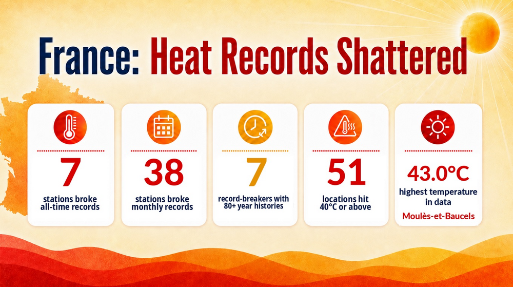
-
Tomorrow will be somewhat milder with highs in the upper 70s. Thursday will see readings return to the 80s and the Friday could see highs in the upper 80s. A few of the hot spots could approach or reach 90°. The weekend will turn somewhat cooler with highs mainly in the lower 80s. No excessive heat appears likely through mid-month. The ENSO Region 1+2 anomaly was +3.4°C and the Region 3.4 anomaly was +1.8°C for the week centered around July 1. For the past six weeks, the ENSO Region 1+2 anomaly has averaged +2.80°C and the ENSO Region 3.4 anomaly has averaged +1.52°C. The ongoing El Niño will continue to strengthen through the summer. The SOI is not available due to data feed issues. This could be an extended issue. The preliminary Arctic Oscillation (AO) was +1.023 today. Based on sensitivity analysis applied to the latest guidance, there is an implied near 61% probability that New York City will have a warmer than normal July (1991-2020 normal). July will likely finish with a mean temperature near 78.6° (1.1° above normal). Supplemental Information: The projected mean would be 2.1° above the 1981-2010 normal monthly value.
-
Occasional Thoughts on Climate Change
donsutherland1 replied to donsutherland1's topic in Climate Change
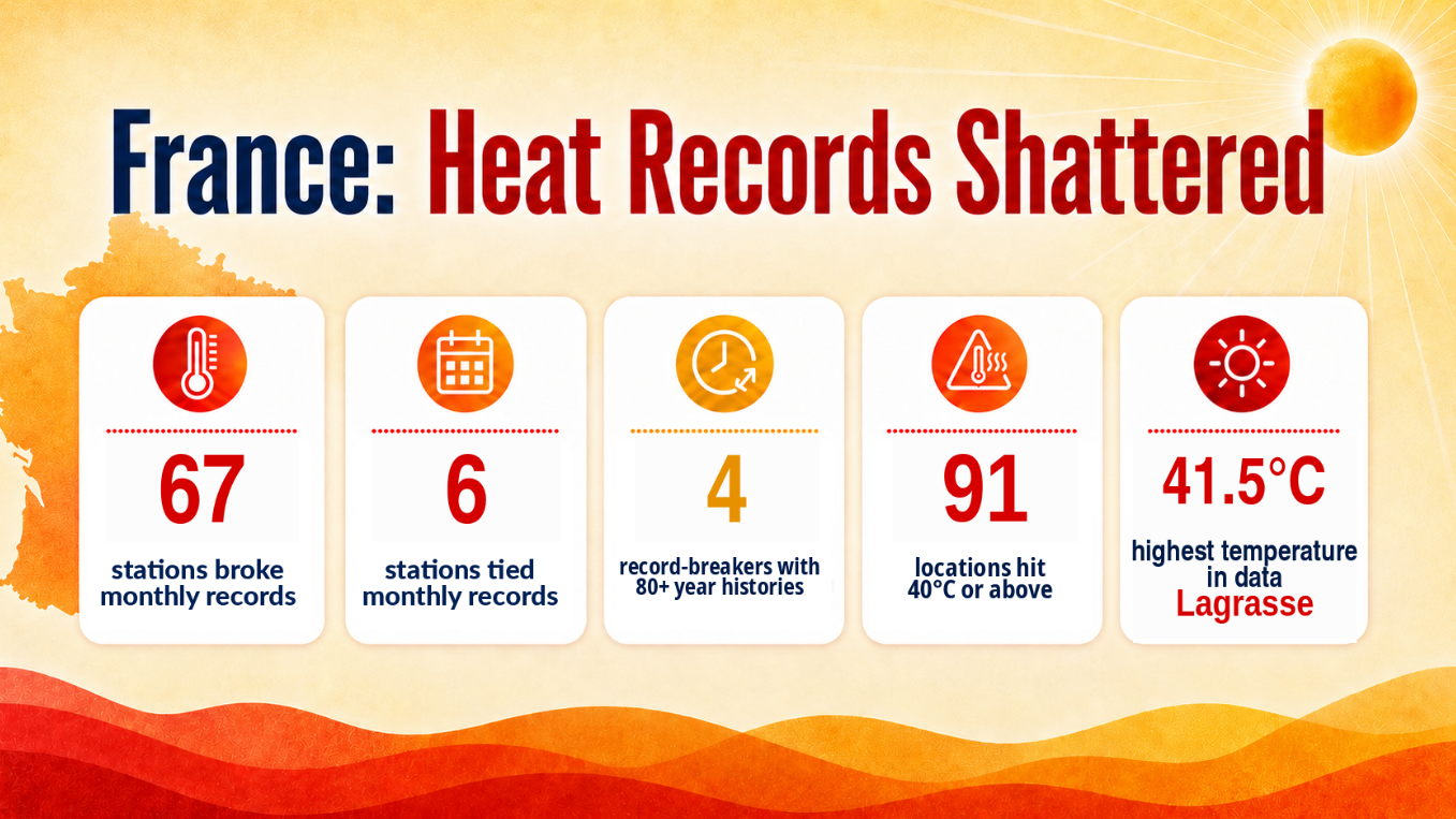
Just as had been the case in 2019, France is being hit by heatwave after heatwave. Following June's record-breaking heat, France is again in the midst of an extreme heatwave. Dozens of July monthly records have fallen. The next 5-7 days will feature a continuation of excessive heat.
-
Snow rooms: https://www.nytimes.com/2026/07/04/style/snow-rooms-home-technoalpin.html?unlocked_article_code=1.v1A.xAsJ.i6M32dlKAMai&smid=url-share
-
203 NOUS41 KOKX 070111 PNSOKX CTZ005>012-NJZ002-004-006-103>108-NYZ067>075-078>081-176>179-071311- Public Information Statement National Weather Service New York NY 911 PM EDT Mon Jul 6 2026 ...PRECIPITATION REPORTS FROM THE LAST 48 HOURS... Location Amount Time/Date Provider ...Connecticut... ...Fairfield County... Danbury 6.40 in 0815 PM 07/06 CWOP NEWTOWN 5.89 in 0820 PM 07/06 CWOP Danbury 5.52 in 0817 PM 07/06 CWOP 1 WNW Redding 5.38 in 0820 PM 07/06 AWS Shelton 4.65 in 0820 PM 07/06 CWOP Ridgefield 4.34 in 0823 PM 07/06 AWS 2 SW Newtown 4.22 in 0515 PM 07/06 Amateur Radio SHELTON 4.20 in 0811 PM 07/06 CWOP Redding Ridge 4.18 in 0815 PM 07/06 CWOP Bridgeport Airport 4.16 in 0822 PM 07/06 ASOS REDDING 4.12 in 0819 PM 07/06 CWOP Weston 3.33 in 0825 PM 07/06 AWS Stamford 3.32 in 0820 PM 07/06 AWS Fairfield 3.29 in 0815 PM 07/06 CWOP Westport 3.25 in 0815 PM 07/06 CWOP STAMFORD 2.26 in 0815 PM 07/06 CWOP Greenwich 2.02 in 0819 PM 07/06 CWOP 3 N New Canaan 1.79 in 0825 PM 07/06 AWS ...Middlesex County... Saybrook Manor 4.51 in 0825 PM 07/06 AWS Westbrook 4.40 in 0815 PM 07/06 CWOP Clinton 4.01 in 0820 PM 07/06 AWS MOODUS 3.44 in 0816 PM 07/06 CWOP 3.5 NW Durham 2.92 in 0800 PM 07/06 HADS Durham 2.78 in 0817 PM 07/06 CWOP Chester Center 2.7 WNW 2.41 in 0643 PM 07/06 COCORAHS ...New Haven County... Milford 5.36 in 0815 PM 07/06 CWOP Stony Creek 5.23 in 0816 PM 07/06 CWOP ORANGE 4.79 in 0815 PM 07/06 CWOP HAMDEN 4.67 in 0820 PM 07/06 CWOP Seymour 4.61 in 0820 PM 07/06 CWOP New Haven Airport 4.44 in 0827 PM 07/06 ASOS Outer Island, Branford 4.33 in 0825 PM 07/06 AWS PROSPECT 4.22 in 0815 PM 07/06 CWOP New Haven 4.11 in 0825 PM 07/06 AWS 4 NW Hamden 4.06 in 0824 PM 07/06 AWS Oxford 3.98 in 0813 PM 07/06 CWOP Waterbury Airport 3.89 in 0756 PM 07/06 AWOS WOODBRIDGE 3.87 in 0820 PM 07/06 CWOP Bethany 3.51 in 0811 PM 07/06 CWOP Wallingford 3.35 in 0801 PM 07/06 CWOP Meriden Airport 3.33 in 0753 PM 07/06 ASOS NORTH PORT 3.24 in 0815 PM 07/06 CWOP Branford 3.19 in 0815 PM 07/06 CWOP ...New London County... New London 3.18 in 0816 PM 07/06 CWOP Pawcatuck 2.80 in 0820 PM 07/06 CWOP GROTON 2.57 in 0815 PM 07/06 CWOP Lyme 2.56 in 0815 PM 07/06 CWOP SALEM 2.49 in 0815 PM 07/06 CWOP Groton Airport 2.22 in 0756 PM 07/06 ASOS Niantic 2.00 in 0408 PM 07/06 Public Lisbon 1.32 in 0820 PM 07/06 CWOP ...New Jersey... ...Bergen County... 1 SSE Franklin Lakes 1.94 in 0745 PM 07/06 IFLOWS Fair Lawn 1.66 in 0820 PM 07/06 CWOP RIVER EDGE 1.63 in 0815 PM 07/06 CWOP Emerson 1.59 in 0808 PM 07/06 CWOP New Milford 1.54 in 0820 PM 07/06 AWS Oakland 1.51 in 0820 PM 07/06 CWOP Tenafly 1.48 in 0815 PM 07/06 CWOP Bergenfield 1.28 in 0815 PM 07/06 CWOP Lyndhurst 1.23 in 0812 PM 07/06 AWS Bogota 1.21 in 0823 PM 07/06 AWS Lodi 1.20 in 0745 PM 07/06 IFLOWS Hasbrouck Heights 1.16 in 0819 PM 07/06 CWOP Teterboro Airport 1.09 in 0751 PM 07/06 ASOS ...Essex County... 0.6 SW Caldwell 1.88 in 0745 PM 07/06 IFLOWS 1.6 W Millburn 1.55 in 0815 PM 07/06 HADS WEST CALDWELL 1.52 in 0815 PM 07/06 CWOP Montclair 1.37 in 0825 PM 07/06 AWS West Caldwell 1.28 in 0820 PM 07/06 CWOP Caldwell 1.18 in 0816 PM 07/06 ASOS Millburn 1.01 in 0825 PM 07/06 AWS ...Hudson County... Secaucus 1.17 in 0825 PM 07/06 AWS Harrison 1.16 in 0416 PM 07/06 CO-OP Observer ...Passaic County... WAYNE 1.81 in 0815 PM 07/06 CWOP Ringwood 1.72 in 0810 PM 07/06 RAWS West Milford 1.72 in 0745 PM 07/06 IFLOWS North Haledon 1.62 in 0820 PM 07/06 CWOP 1.5 SW Ringwood 1.60 in 0745 PM 07/06 IFLOWS 2 ESE Barry Lakes 1.51 in 0825 PM 07/06 AWS Oak Ridge Reservoir 1.48 in 0745 PM 07/06 COOP 0.8 E West Paterson 1.48 in 0800 PM 07/06 HADS Hawthorne 1.45 in 0820 PM 07/06 CWOP 0.8 SE Pompton Lakes 1.45 in 0800 PM 07/06 HADS 2.1 E Ringwood 1.40 in 0745 PM 07/06 IFLOWS CLIFTON 1.32 in 0818 PM 07/06 CWOP Charlottesburg Reservoir 1.32 in 0745 PM 07/06 COOP Clifton 1.10 in 0820 PM 07/06 AWS Wayne 1.08 in 0815 PM 07/06 CWOP 0.9 S Wayne 1.00 in 0745 PM 07/06 IFLOWS ...Union County... Linden Airport 1.59 in 0815 PM 07/06 AWOS Union 1.54 in 0815 PM 07/06 CWOP Mountainside 1.16 in 0730 PM 07/06 IFLOWS Newark Airport 1.12 in 0751 PM 07/06 ASOS ...New York... ...Bronx County... Fordham 1.46 in 0815 PM 07/06 NYSM 1 NE Harlem 1.30 in 0825 PM 07/06 AWS ...Kings County... BROOKLYN 4.45 in 0811 PM 07/06 CWOP Brooklyn College 3.19 in 0815 PM 07/06 NYSM Dyker Heights 2.39 in 0820 PM 07/06 CWOP Brooklyn 2.16 in 0816 PM 07/06 CWOP ...Nassau County... NORTH MASSAPEQUA 4.62 in 0818 PM 07/06 CWOP North Massapequa 4.28 in 0815 PM 07/06 CWOP Oyster Bay 3.66 in 0815 PM 07/06 CWOP Farmingdale 3.59 in 0815 PM 07/06 CWOP Bethpage 3.49 in 0823 PM 07/06 AWS LONG BEACH 3.46 in 0818 PM 07/06 CWOP Levittown 3.36 in 0815 PM 07/06 CWOP Syosset 3.35 in 0820 PM 07/06 CWOP Massapequa Park 3.08 in 0815 PM 07/06 CWOP SYOSSET 2.99 in 0818 PM 07/06 CWOP Wantagh 2.77 in 0815 PM 07/06 NYSM Bellmore 2.75 in 0818 PM 07/06 CWOP MASSAPEQUA 2.72 in 0816 PM 07/06 CWOP East Rockaway 2.64 in 0818 PM 07/06 CWOP MASSAPEQUA 2.64 in 0818 PM 07/06 CWOP Valley Stream 2.49 in 0816 PM 07/06 CWOP Hicksville 2.40 in 0820 PM 07/06 CWOP 1 ESE Long Beach 2.30 in 0820 PM 07/06 AWS Muttontown 2.23 in 0815 PM 07/06 CWOP Merrick 2.20 in 0735 PM 07/06 CWOP PORT WASHINGTON 2.03 in 0810 PM 07/06 CWOP OLD WESTBURY 1.67 in 0815 PM 07/06 CWOP North Merrick 1.65 in 0815 PM 07/06 CWOP ...New York (Manhattan) County... Battery Park 1.52 in 0824 PM 07/06 AWS Central Park 1.29 in 0751 PM 07/06 ASOS ...Orange County... Otisville 8.40 in 0815 PM 07/06 NYSM Montgomery 6.22 in 0815 PM 07/06 CWOP Newburgh 5.40 in 0806 PM 07/06 CWOP Port Jervis 5.40 in 0818 PM 07/06 CWOP 4 SSE Middletown 5.12 in 0550 PM 07/06 AWS US Military Academy 5.05 in 0655 PM 07/06 RAWS CORNWALL ON HUDSON 4.88 in 0816 PM 07/06 CWOP NEW WINDSOR 4.84 in 0815 PM 07/06 CWOP Vails Gate 4.25 in 0816 PM 07/06 CWOP 1 N Chester 4.01 in 0301 PM 07/06 Cocorahs Chester 3.92 in 0820 PM 07/06 CWOP Warwick 3.92 in 0815 PM 07/06 NYSM 2.6 NW Tuxedo Park 3.68 in 0745 PM 07/06 HADS Harriman 3.03 in 0824 PM 07/06 AWS Port Jervis 3.01 in 0825 PM 07/06 AWS Walden 2.84 in 0818 PM 07/06 CWOP Tuxedo Park 1.84 in 0825 PM 07/06 AWS Washingtonville 1.37 in 0820 PM 07/06 CWOP ...Putnam County... Mahopac 4.03 in 0825 PM 07/06 AWS Lake Carmel 3.94 in 0815 PM 07/06 CWOP Brewster 3.31 in 0815 PM 07/06 NYSM ...Queens County... OZONE PARK 3.52 in 0816 PM 07/06 CWOP NYC/JFK Airport 2.63 in 0751 PM 07/06 ASOS Kew Garden Hills 2.09 in 0815 PM 07/06 NYSM NYC/La Guardia 1.17 in 0829 PM 07/06 ASOS Beechhurst 1.03 in 0820 PM 07/06 CWOP ...Richmond County... College of Staten Island 2.38 in 0815 PM 07/06 NYSM Eltingville 2.30 in 0815 PM 07/06 CWOP ...Rockland County... Stony Point 5.00 in 0824 PM 07/06 AWS 1 SSW Mount Ivy 2.62 in 0824 PM 07/06 AWS New City 2.49 in 0823 PM 07/06 AWS Blauvelt 2.38 in 0815 PM 07/06 CWOP Spring Valley 2.32 in 0815 PM 07/06 CWOP Nanuet 1.83 in 0730 PM 07/06 IFLOWS Bardonia 1.81 in 0823 PM 07/06 AWS Suffern 1.46 in 0815 PM 07/06 NYSM Montebello 1.36 in 0815 PM 07/06 CWOP ...Suffolk County... 1 WSW West Islip 4.41 in 0815 PM 07/06 Trained Spotter North Babylon 4.33 in 0815 PM 07/06 CWOP ORIENT 3.83 in 0820 PM 07/06 CWOP 1 SW Babylon 3.80 in 0758 PM 07/06 Amateur Radio Copiague 3.76 in 0800 PM 07/06 Amateur Radio 1 ESE Copiague 3.70 in 0749 PM 07/06 Public Orient 3.70 in 0846 PM 07/06 CO-OP Observer Melville 3.62 in 0815 PM 07/06 CWOP 1 NNW Copiague 3.56 in 0646 PM 07/06 Trained Spotter East Hampton 3.53 in 0820 PM 07/06 CWOP Farmingdale Airport 3.33 in 0753 PM 07/06 ASOS Miller Place 3.32 in 0820 PM 07/06 CWOP COMMACK 3.25 in 0819 PM 07/06 CWOP Saint James 3.19 in 0814 PM 07/06 CWOP SMITHTOWN 3.11 in 0815 PM 07/06 CWOP 2 WNW Riverhead 3.10 in 0823 PM 07/06 AWS North Patchogue 2.95 in 0820 PM 07/06 CWOP Stony Brook 2.94 in 0811 PM 07/06 CWOP Dix Hills 2.92 in 0819 PM 07/06 CWOP East Setauket 2.91 in 0816 PM 07/06 CWOP ISLIP 2.91 in 0815 PM 07/06 CWOP Blue Point 2.84 in 0815 PM 07/06 CWOP 3.6 NE Calverton 2.84 in 0500 PM 07/06 COOP Islip Airport 2.83 in 0756 PM 07/06 ASOS 1 WNW Oakdale 2.78 in 0636 PM 07/06 Trained Spotter West Gilgo Beach 2.78 in 0820 PM 07/06 CWOP N. Babylon 2.68 in 0820 PM 07/06 CWOP 1 ENE Cold Spring Harbor 2.55 in 0530 PM 07/06 Public ISLIP 2.54 in 0817 PM 07/06 CWOP Sayville 2.45 in 0813 PM 07/06 CWOP FAIR HARBOR 2.44 in 0818 PM 07/06 CWOP Ridge 2.43 in 0816 PM 07/06 CWOP Amityville 2.35 in 0304 PM 07/06 Trained Spotter Old Field 2.27 in 0825 PM 07/06 AWS Shirley 2.27 in 0815 PM 07/06 CWOP Smithtown 2.22 in 0815 PM 07/06 CWOP Eastport 2.21 in 0745 PM 07/06 RAWS Westhampton Airport 2.18 in 0753 PM 07/06 ASOS 1 NNW East Patchogue 2.00 in 0242 PM 07/06 Public Northport 1.97 in 0820 PM 07/06 CWOP Southold 1.97 in 0815 PM 07/06 CWOP Manorville 2.8 NE 1.95 in 0430 PM 07/06 COCORAHS 1 E East Hampton Airport 1.94 in 0755 PM 07/06 AWOS Montauk Airport 1.83 in 0754 PM 07/06 ASOS Remsenburg 1.71 in 0815 PM 07/06 CWOP Kings Park 1.59 in 0815 PM 07/06 CWOP ...Westchester County... 1 S Peach Lake 6.04 in 0825 PM 07/06 AWS Somers 5.51 in 0815 PM 07/06 NYSM Mount Kisco 5.07 in 0819 PM 07/06 CWOP 3 ESE Goldens Bridge 3.29 in 0807 PM 07/06 AWS Yorktown Heights 3.11 in 0820 PM 07/06 AWS Ossining 2.14 in 0818 PM 07/06 CWOP Pleasantville 2.06 in 0825 PM 07/06 AWS Rye Brook 1.98 in 0824 PM 07/06 AWS PORT CHESTER 1.97 in 0817 PM 07/06 CWOP White Plains Airport 1.83 in 0756 PM 07/06 ASOS Tarrytown 1.81 in 0817 PM 07/06 CWOP Armonk 1.72 in 0815 PM 07/06 CWOP CHAPPAQUA 1.71 in 0816 PM 07/06 CWOP Rye 1.65 in 0825 PM 07/06 AWS SCARSDALE 1.58 in 0815 PM 07/06 CWOP New Rochelle 1.55 in 0815 PM 07/06 CWOP &&
-
I can't say that there is a single cause. Stochastic variability, the rapid rise of the ongoing strong El Niño, and myriad marine heatwaves are all affecting the patterns and pattern evolution.
-
The four-day interval between Central Park's high of 100° on July 2 and its high of 69° yesterday is the shortest on record between a high of 100° or above and a high in the 60s. The old record of 10 days was set from July 3-13, 1898 and tied during August 1-11, 1933. Records go back to 1869.
-
As of 7:05 pm, New Haven has picked up 3.14" of rain today. That smashes the daily mark of 1.35" from 2019. It is also the 4th heaviest daily rainfall on record for July.