donsutherland1
-
Posts
24,192 -
Joined
Content Type
Profiles
Blogs
Forums
American Weather
Media Demo
Store
Gallery
Everything posted by donsutherland1
-
With the strong and strengthening El Niño, the odds are probably against a return to 100s.
-
Occasional Thoughts on Climate Change
donsutherland1 replied to donsutherland1's topic in Climate Change
This paper has some information on time of observation bias. Hundreds of stations once recorded afternoon resets. https://www.ncei.noaa.gov/pub/data/ushcn/papers/menne-etal2009.pdf -
A cooler regime is in place and will remain in place through the remainder of July. Highs will generally reach the lower 80s through much or all of the remainder of July. The warmest spots could reach the middle 80s on occasion. The ENSO Region 1+2 anomaly was +3.6°C and the Region 3.4 anomaly was +2.1°C for the week centered around July 15. For the past six weeks, the ENSO Region 1+2 anomaly has averaged +3.20°C and the ENSO Region 3.4 anomaly has averaged +1.82°C. The ongoing strong El Niño will continue to strengthen through the summer. The SOI was -17.36 yesterday. The preliminary Arctic Oscillation (AO) was -0.144 today. Based on sensitivity analysis applied to the latest guidance, there is an implied near 72% probability that New York City will have a cooler than normal July (1991-2020 normal). July will likely finish with a mean temperature near 76.6° (0.9° below normal). Supplemental Information: The projected mean would be 0.1° above the 1981-2010 normal monthly value.
-
Occasional Thoughts on Climate Change
donsutherland1 replied to donsutherland1's topic in Climate Change
A “must read” piece on climate, data, and data manipulation: https://www.theclimatebrink.com/p/hot-days-cold-thermometers -
A cooler regime is in place and will remain in place through the remainder of July. Highs will generally reach the upper 70s and lower 80s through the week and into the start of the weekend. A few more Showers and thunderstorms are likely tonight into tomorrow. With an estimated 4.73" of rain as per precip.ai, White Plains smashed its daily rainfall record of 2.20" from 1973. The ENSO Region 1+2 anomaly was +3.6°C and the Region 3.4 anomaly was +2.1°C for the week centered around July 15. For the past six weeks, the ENSO Region 1+2 anomaly has averaged +3.20°C and the ENSO Region 3.4 anomaly has averaged +1.82°C. The ongoing strong El Niño will continue to strengthen through the summer. The SOI was -17.36 today. The preliminary Arctic Oscillation (AO) was -0.673 today. Based on sensitivity analysis applied to the latest guidance, there is an implied near 74% probability that New York City will have a cooler than normal July (1991-2020 normal). July will likely finish with a mean temperature near 76.6° (0.9° below normal). Supplemental Information: The projected mean would be 0.1° above the 1981-2010 normal monthly value.
-
Very impressive.
-
And now another station has gone offline. The increasingly frequent radar downtime and station data disruptions is disconcerting, not just from the perspective of tracking events.

-
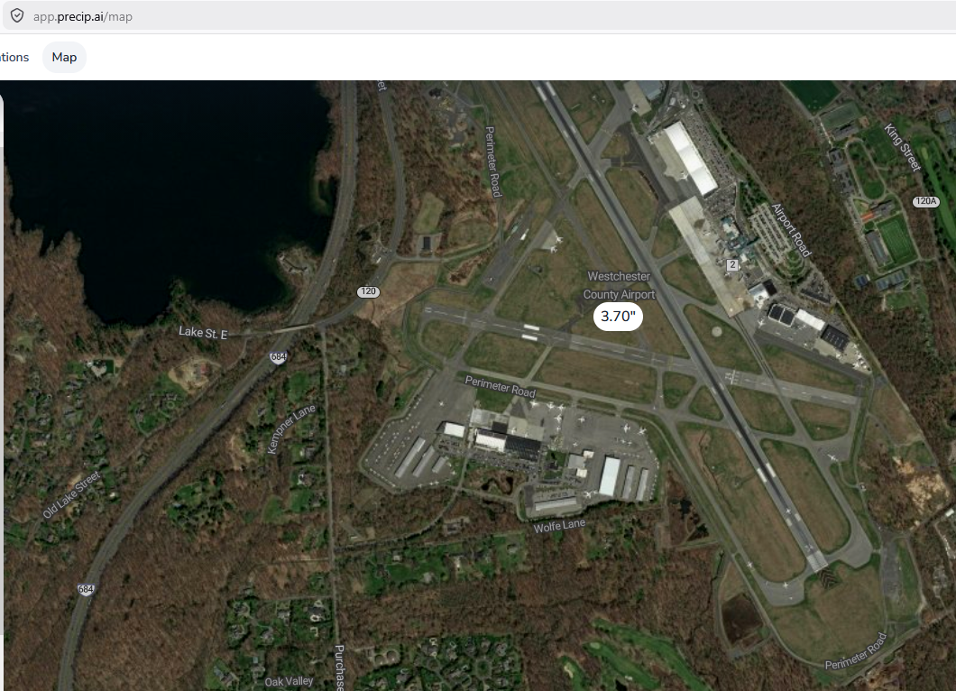
Westchester County Airport picked up 1.08" of rain in the past hour. One hour of heavy rainfall is missing from the Airport's reporting. Nevertheless, based on radar estimates, flash flood reports, and precip.AI, the daily record of 2.20" from 1973 has been broken. The precip.ai estimate is 3.70" has fallen there so far. Further, based on the precip.ai estimate through 1 pm, the missing hour saw 2.53" of rainfall at Westchester County Airport. That would eclipse the July monthly hourly record (2.15", July 18, 2005) and the all-time hourly mark (2.16", September 1, 2021). Data continuity matters.

-
I agree. It's disappointing that equipment maintenance is no longer a priority.
-
Westchester County Airport has heavy rain, but the sensor is not reporting amounts. Hopefully, it's a communication issue, not a sensor issue. There was a nearly month-long stretch earlier in the year where precipitation amounts weren't recorded.
-
The futurecast is essentially useless at 36-48 hours. It's akin to a 120-hour NAM run (NAM ends at 84 hours, just so one has context for my analogy). Not surprisingly, last night's figures were dramatically lowered and are now in line with the guidance. https://pix11.com/news/local-news/projected-rainfall-totals-in-ny-nj-ahead-of-storms/
-
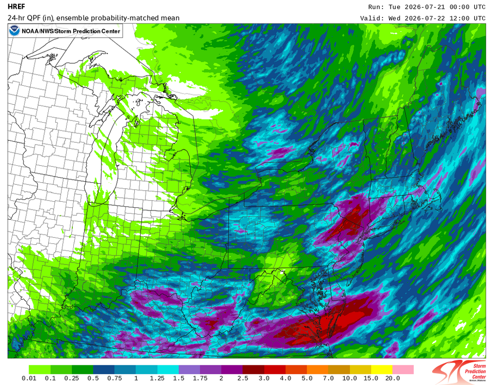
The overnight HREF:
-
What model was the basis of this idea?
-
A cooler regime is in place and will remain in place for an extended period of time. Highs will generally reach the upper 70s and lower 80s through the week and into the start of the weekend. Showers and thunderstorms are likely tomorrow into Wednesday. Some areas could pick up heavy downpours with flooding a possibility. Daily rainfall records for July 21 include: Atlantic City: 4.60", 1969 Bridgeport: 2.16", 1961 Islip: 2.69", 1984 New York City-Central Park: 2.26", 1983 New York City-JFK Airport: 2.45", 1948 New York City-LaGuardia Airport: 2.06", 2006 Newark: 3.23", 2006 Philadelphia: 3.45", 1988 Wilmington, DE: 3.80"m, 1988 The long-term outlook for the remainder of July has swung to near normal or even somewhat cooler than normal on the guidance. The ENSO Region 1+2 anomaly was +3.6°C and the Region 3.4 anomaly was +2.1°C for the week centered around July 15. For the past six weeks, the ENSO Region 1+2 anomaly has averaged +3.20°C and the ENSO Region 3.4 anomaly has averaged +1.82°C. The ongoing strong El Niño will continue to strengthen through the summer. The SOI was -21.79 today. The preliminary Arctic Oscillation (AO) was -0.825 today. Based on sensitivity analysis applied to the latest guidance, there is an implied near 64% probability that New York City will have a cooler than normal July (1991-2020 normal). July will likely finish with a mean temperature near 76.8° (0.7° below normal). Supplemental Information: The projected mean would be 0.3° above the 1981-2010 normal monthly value.
-
Flood Watch National Weather Service New York NY 231 PM EDT Mon Jul 20 2026 NJZ002-004-006-103>108-NYZ072>075-176-178-211000- /O.NEW.KOKX.FA.A.0005.260721T1200Z-260722T0600Z/ /00000.0.ER.000000T0000Z.000000T0000Z.000000T0000Z.OO/ Western Passaic-Eastern Passaic-Hudson-Western Bergen-Eastern Bergen-Western Essex-Eastern Essex-Western Union-Eastern Union- New York (Manhattan)-Bronx-Richmond (Staten Island)-Kings (Brooklyn)-Northern Queens-Southern Queens- 231 PM EDT Mon Jul 20 2026 ...FLOOD WATCH IN EFFECT FROM TUESDAY MORNING THROUGH LATE TUESDAY NIGHT... * WHAT...Flooding caused by excessive rainfall is possible. * WHERE...Portions of northeast New Jersey, including the following areas, Eastern Bergen, Eastern Essex, Eastern Passaic, Eastern Union, Hudson, Western Bergen, Western Essex, Western Passaic and Western Union and southeast New York, including the following areas, Bronx, Kings (Brooklyn), New York (Manhattan), Northern Queens, Richmond (Staten Island) and Southern Queens. * WHEN...From Tuesday morning through late Tuesday night. * IMPACTS...Excessive runoff may result in flooding of rivers, creeks, streams, and other low-lying and flood-prone locations. Flooding may occur in poor drainage and urban areas. * ADDITIONAL DETAILS... - Multiple rounds of showers and thunderstorms are expected Tuesday morning through Tuesday evening. Average rainfall totals will be between 1 and 2 inches, with isolated totals around 3 to 4 inches possible. Peak rainfall rates in the strongest storms could be near 2.5 inches per hour. - http://www.weather.gov/safety/flood PRECAUTIONARY/PREPAREDNESS ACTIONS... You should monitor later forecasts and be alert for possible Flood Warnings. Those living in areas prone to flooding should be prepared to take action should flooding develop.
-
The timing is still very uncertain. Hopefully, there will be greater clarity during the 18z and 0z runs.
-
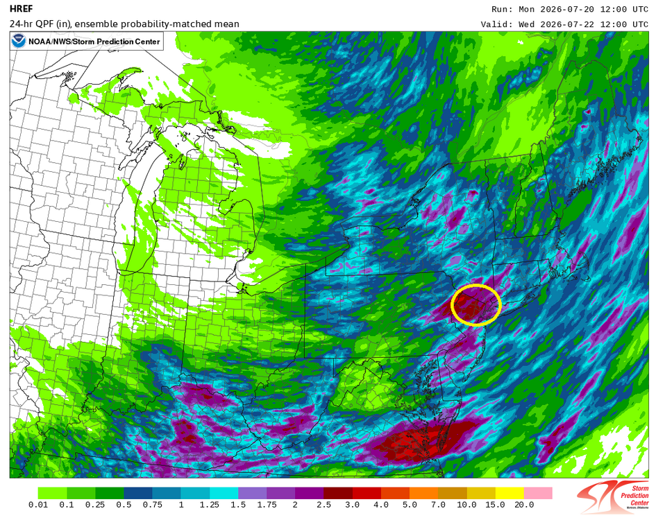
The latest HREF is showing the potential for 1.50"-3.00" of rain across the New York City Metro Area. If this holds through the 0z cycle, it wouldn't surprise me if flood watches are put in place for Tuesday into Wednesday.
-
2026-2027 Super El Nino
donsutherland1 replied to Stormchaserchuck1's topic in Weather Forecasting and Discussion
The weekly ENSO Region 1+2 anomaly rose to +3.6°C during the week centered around July 15. Only the 1982-83 and 1997-98 super El Niño events saw comparable or higher values. The last such anomaly occurred during the week centered around December 24, 1997 (+3.6°C). A strong El Niño is ongoing. -
A cooler regime, less smoky regime has settled into the region just in time for the World Cup final. The pleasant temperature regime will continue for an extended period of time. Highs will generally reach the upper 70s and lower 80s through the week into the start of the weekend. Showers and thunderstorms are possible Tuesday night and Wednesday. Some areas could pick up heavy downpours. The long-term outlook for the remainder of July has swung to near normal or even somewhat cooler than normal on the guidance. The ENSO Region 1+2 anomaly was +3.4°C and the Region 3.4 anomaly was +1.8°C for the week centered around July 1. For the past six weeks, the ENSO Region 1+2 anomaly has averaged +2.80°C and the ENSO Region 3.4 anomaly has averaged +1.52°C. The ongoing strong El Niño will continue to strengthen through the summer. The SOI was -27.15 today. The preliminary Arctic Oscillation (AO) was -0.800 today. Based on sensitivity analysis applied to the latest guidance, there is an implied near 55% probability that New York City will have a cooler than normal July (1991-2020 normal). July will likely finish with a mean temperature near 77.0° (0.5° below normal). Supplemental Information: The projected mean would be 0.5° above the 1981-2010 normal monthly value.
-
2026-2027 Super El Nino
donsutherland1 replied to Stormchaserchuck1's topic in Weather Forecasting and Discussion
It's on course to become a truly monstrous historic event. Its impacts will be far-reaching and probably very severe. -
Showers and thundershowers are possible early tonight. Some of the thunderstorms could bring flooding downpours and strong winds. Highs will generally reach the lower 80s through the middle of next week. Additional showers and thunderstorms are possible Tuesday night into Wednesday. The long-term outlook for the remainder of July has swung to near normal or even somewhat cooler than normal on the guidance. The ENSO Region 1+2 anomaly was +3.4°C and the Region 3.4 anomaly was +1.8°C for the week centered around July 1. For the past six weeks, the ENSO Region 1+2 anomaly has averaged +2.80°C and the ENSO Region 3.4 anomaly has averaged +1.52°C. The ongoing strong El Niño will continue to strengthen through the summer. The SOI was -23.95 today. The preliminary Arctic Oscillation (AO) was -0.735 today. Based on sensitivity analysis applied to the latest guidance, there is an implied near 50% probability that New York City will have a warmer than normal July (1991-2020 normal). July will likely finish with a mean temperature near 77.5° (near normal). Supplemental Information: The projected mean would be 1.0° above the 1981-2010 normal monthly value.
-
An observation one doesn't off see in the NYC area from LaGuardia Airport this morning:

-
Two photos of the smoke that returned. It's nowhere near as thick or at the low level as it was on Thursday.
-
Narrative artwork for this morning: AQI: 196 (parts of the NYC area are above 200).

-
Showers and thundershowers are possible during the weekend. Some of the thunderstorms could bring flooding downpours and strong winds. The greatest risk is tomorrow night and Sunday. Highs will generally reach the lower 80s through the middle of next week. Additional showers and thunderstorms are possible Tuesday night into Wednesday. The ENSO Region 1+2 anomaly was +3.4°C and the Region 3.4 anomaly was +1.8°C for the week centered around July 1. For the past six weeks, the ENSO Region 1+2 anomaly has averaged +2.80°C and the ENSO Region 3.4 anomaly has averaged +1.52°C. The ongoing strong El Niño will continue to strengthen through the summer. The SOI was -27.09 today. The preliminary Arctic Oscillation (AO) was -0.683 today. Based on sensitivity analysis applied to the latest guidance, there is an implied near 55% probability that New York City will have a warmer than normal July (1991-2020 normal). July will likely finish with a mean temperature near 78.0° (0.5° above normal). Supplemental Information: The projected mean would be 1.5° above the 1981-2010 normal monthly value.