donsutherland1
-
Posts
23,988 -
Joined
Content Type
Profiles
Blogs
Forums
American Weather
Media Demo
Store
Gallery
Everything posted by donsutherland1
-
No. The long-duration block should provide just enough cool weather to result in a modest cool anomaly for October.
-
2025-2026 ENSO
donsutherland1 replied to 40/70 Benchmark's topic in Weather Forecasting and Discussion
This is the kind of nonsense that is put out on Social Media that makes the profession look bad. On an RMSE basis for July-September, 2010 is the 27th worst match with 2025 since 1948. Year Jan Feb Mar Apr May Jun Jul Aug Sep Oct Nov Dec 2010 -16.02 -16.98 -19.68 -23.57 -26.28 -25.05 -9.84 1.45 6.58 10.83 12.16 10.97 2011 9.18 10.05 10.44 10.71 10.02 3.90 0.44 -0.49 -2.30 -3.05 -9.09 -16.25 2025 12.11 10.55 11.82 6.94 -4.59 -13.72 -19.99 -22.28 -24.26 Finally, it looks like he generated his table using AI. I have no idea how he came up with his October+subsequent QBO forecasts. The largest monthly increase on record is +16.90 from April-May 2024. The largest October increase on record is +8.78 from September-October 1994. He fed bad information into AI to get these QBO results. In general, bad data + bad prompts = bad AI-generated results. -
An AO-/NAO-/PNA+ blocking regime is in place. As a result, an extended period of cooler than normal weather will prevail through the end of the month. Highs tomorrow will top out in the upper 50s tomorrow. It will then turn even cooler during the weekend. Temperatures will reach the lower and middle 50s. The unseasonably cool weather will continue into at least the middle of next week. There is a possibility that the closing days of October into the opening days of November could experience a significant rain event. The ENSO Region 1+2 anomaly was -0.4°C and the Region 3.4 anomaly was -0.6°C for the week centered around October 15. For the past six weeks, the ENSO Region 1+2 anomaly has averaged -0.15°C and the ENSO Region 3.4 anomaly has averaged -0.47°C. La Niña conditions will likely continue through mid-winter. The SOI was +17.47 today. The preliminary Arctic Oscillation (AO) was -0.527 today. Based on sensitivity analysis applied to the latest guidance, there is an implied 51% probability that New York City will have a cooler than normal October (1991-2020 normal). October will likely finish with a mean temperature near 57.8° (0.1° below normal). Supplemental Information: The projected mean would be 0.9° above the 1981-2010 normal monthly value.
-
Occasional Thoughts on Climate Change
donsutherland1 replied to donsutherland1's topic in Climate Change
I didn’t question that piece from the op-ed. It might be useful also to look at how things are projected to change as warming continues. -
Strong blocking regimes often result in cooler than normal conditions, even at this time of year when wave lengths are shorter. The strongly negative NAO is having an influence. The NAO has now been at or below -1.000 for six consecutive days and is forecast to remain between -2.000 and -1.000 through the rest of the month. Select Mean Temperature Data for October 22-31, 1980-2024: NAO -2.000 to -1.000: 51.0° All Other Cases: 55.0° 1980-2024 Mean: 54.3°
-
An AO-/PNA+ blocking regime has developed. As a result, an extended period of cooler than normal weather lies ahead. Highs tomorrow will top out in the upper 50s tomorrow and Friday. It will then turn even cooler during the weekend. Temperatures will reach the lower and middle 50s. The unseasonably cool weather will continue into at least early next week. There is a possibility that the closing days of October into the opening days of November could experience a significant rain event. The ENSO Region 1+2 anomaly was -0.4°C and the Region 3.4 anomaly was -0.6°C for the week centered around October 15. For the past six weeks, the ENSO Region 1+2 anomaly has averaged -0.15°C and the ENSO Region 3.4 anomaly has averaged -0.47°C. La Niña conditions will likely continue through mid-winter. The SOI was +15.73 today. The preliminary Arctic Oscillation (AO) was -0.694 today. Based on sensitivity analysis applied to the latest guidance, there is an implied 51% probability that New York City will have a warmer than normal October (1991-2020 normal). October will likely finish with a mean temperature near 58.0° (0.1° above normal). Supplemental Information: The projected mean would be 1.1° above the 1981-2010 normal monthly value.
-
Occasional Thoughts on Climate Change
donsutherland1 replied to donsutherland1's topic in Climate Change
The op-ed aims to use selective statistics stripped of context to make the reader question the seriousness of climate change. The author claims that “climate-related deaths from floods, droughts, storms and wildfires... have declined by an astonishing 98%.” This statement is presented as a fact-based contrast to what he calls “alarmist narratives” about the climate. By highlighting this statistic, the author suggests that while the planet might be warming, it hasn’t made life more dangerous. This strategy of "implied argument" is intended to lead the reader to infer that the impacts of climate change are exaggerated. It is a dishonest tactic. That tactic is based on material omission of the very reason climate-related deaths has fallen, which has nothing to do with the author's thesis that the climate change threat is overstated. Finally, I didn't remove those four variables. The author did in order to make his misleading claim through implied argument. -
October 2025 has a global mean temperature of 15.29°C through October 20th (ERA-5). That ranks as the third warmest October 1-20 period on record. October 2025 remains on track to finish as the third warmest October on record (likely with a monthly mean temperature of 15.00°C or above). To miss, the October 21-31 period would need to see sustained cool readings that last occurred in 2013. That is improbable with today's greater greenhouse gas forcing.
-
Occasional Thoughts on Climate Change
donsutherland1 replied to donsutherland1's topic in Climate Change
This is a patently misleading piece. While it correctly observes that “climate-related deaths… have declined by 98%,” it omits the critical context that renders the statistic meaningful. These deaths have not fallen because the climate has become more stable or benign. They have fallen because humanity has vastly improved its capacity to anticipate and withstand disasters through through advances in forecasting, infrastructure, public health, and global wealth. Without these four variables, the claim would be indefensible. The article also misrepresents the scientific community by alleging that climate scientists “suppress” inconvenient facts. In reality, the scientific literature is filled with discussions of uncertainties, feedbacks, and trade-offs. Vigorous internal debate is a defining feature of climate science, not evidence of censorship. What is not in dispute is that the primary driver of ongoing climate change is anthropogenic greenhouse gas emissions. That conclusion is based on converging lines of empirical evidence and fundamental physical principles. Given this state of knowledge, the burden of proof now rests squarely on self-described skeptics. If they wish to challenge the established consensus, they must produce a credible, coherent, and empirically validated alternative theory. Their theory must be capable of explaining the observed climate evolution at least as well as the current scientific framework. Mere objections are not sufficient. That won't happen. To succeed, such skeptics would have to overturn the basic physics of radiative transfer and atmospheric thermodynamics that underpin understanding of anthropogenic climate change. -
Occasional Thoughts on Climate Change
donsutherland1 replied to donsutherland1's topic in Climate Change
The paper describes precisely what one would expect when the linear stability of a complex system begins to erode. The “pushing and triggering” forces are now overwhelming the Arctic’s stabilizing feedbacks. As a result, the ocean–ice–atmosphere system is reorganizing into a new regime that is defined by higher temperatures, diminished sea ice, accelerated ice-sheet loss, and increasingly frequent and intense climatic extremes. On account of of Earth-system hysteresis, once a new state emerges, atmospheric CO2 concentrations would have to fall well below current levels merely to restore the Arctic to its present state. Such a reversal appears extraordinarily unlikely in any plausible future scenario. Despite clear scientific evidence and full awareness of the consequences of amplified greenhouse forcing, humanity continues to pursue a trajectory of intensifying emissions. During the Mid-Pliocene, the Arctic was roughly 7°C to 10°C warmer than the pre-industrial baseline, even at CO2 levels comparable to today’s. This suggests that substantial additional warming lies ahead. Humanity’s climate-engineering effort, which can no longer be described as inadvertent given today's state of knowledge, has already driven the Arctic roughly one-third to one-half of the way toward a Mid-Pliocene state. In that period, Greenland’s ice sheet was drastically smaller, and the Arctic Ocean was seasonally ice-free. Given the constraints of human cognition and the deep inertia shaping collective decision-making, it is difficult to imagine this paper will meaningfully alter society’s choice to continue to dump vast amounts of greenhouse gases into the atmosphere. -
2025 Atlantic Hurricane Season
donsutherland1 replied to BarryStantonGBP's topic in Tropical Headquarters
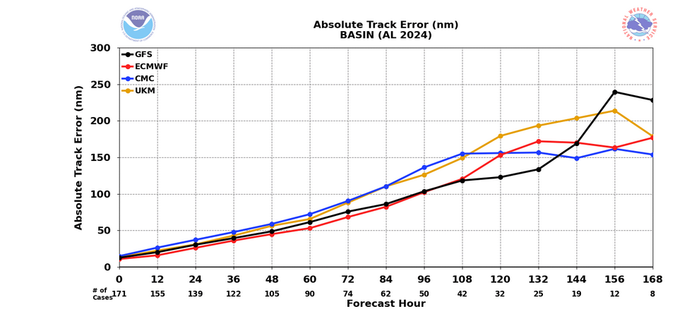
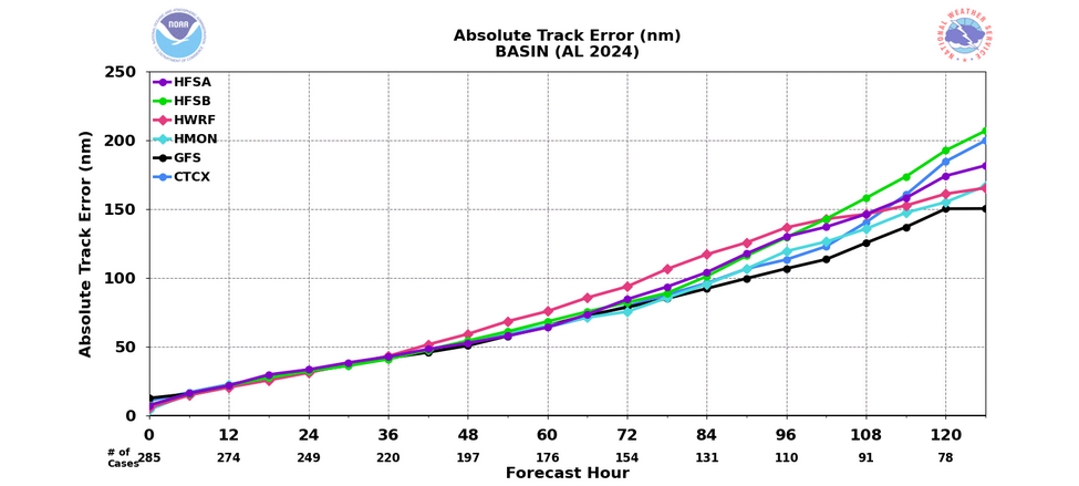
For reference, model skill scores: Global Models: Ensembles: Hurricane Models: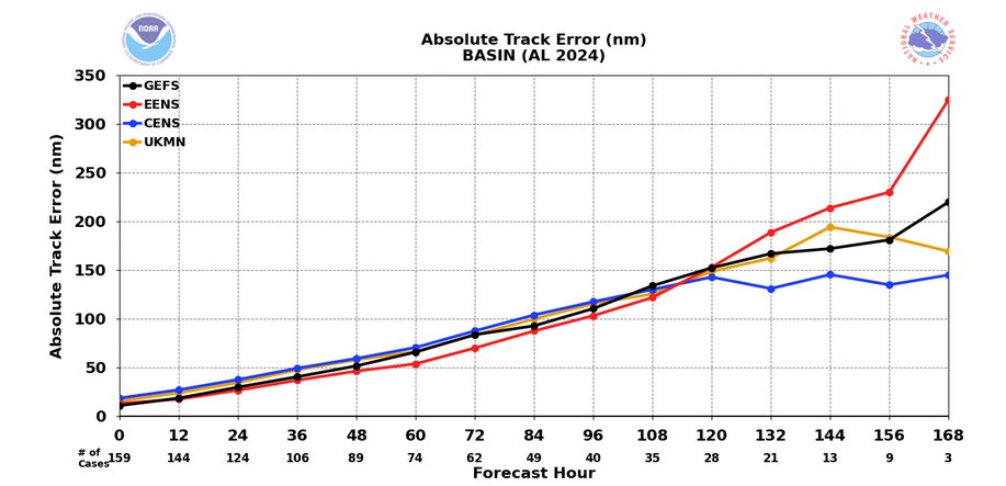
-
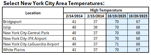
Both dates occurred during snowfall. February 13-14, 2014 saw a storm dump 12.5" of snow (with a period of heavy windswept rain). A second system brought another 1.6" of snow. Those are Central Park figures.
-
The winds and stochastic variability likely contributed.
-
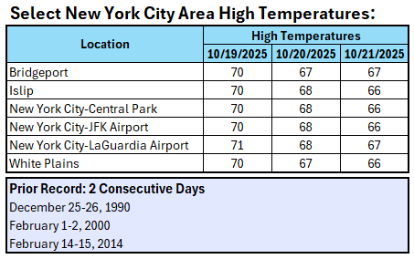
Today was the third consecutive day with a one-degree difference in high temperatures among Bridgeport, Islip, Central Park, JFK Airport, LaGuardia Airport, and White Plains. That set a new record for most consecutive such days.
-
A strong cold front will move across the region tonight. Parts of the region will see some showers and perhaps a thundershower. Following the frontal passage, an extended period of cooler than normal weather will follow. Highs tomorrow will top out in the lower 60s. Readings will then rise only into the middle and upper 50s through at least the coming weekend. There is a growing likelihood that the closing days of October into the opening days of November could experience a significant rain event. The ENSO Region 1+2 anomaly was -0.4°C and the Region 3.4 anomaly was -0.6°C for the week centered around October 15. For the past six weeks, the ENSO Region 1+2 anomaly has averaged -0.15°C and the ENSO Region 3.4 anomaly has averaged -0.47°C. La Niña conditions will likely continue through mid-winter. The SOI was +15.15 today. The preliminary Arctic Oscillation (AO) was -0.870 today. Based on sensitivity analysis applied to the latest guidance, there is an implied 56% probability that New York City will have a warmer than normal October (1991-2020 normal). October will likely finish with a mean temperature near 58.4° (0.5° above normal). Supplemental Information: The projected mean would be 1.5° above the 1981-2010 normal monthly value.
-
Yes, some of the ECMWF runs have been wildly unrealistic. Above normal rainfall is possible, though.
-
I don’t think any tropical cyclone will make landfall. Some moisture could be tapped, allowing for an enhancement of rainfall.
-
Frontal passage possibly slowed by blocking, allowing for greater precipitation. There are some hints of a tropical moisture connection. Details remain to be resolved.
-
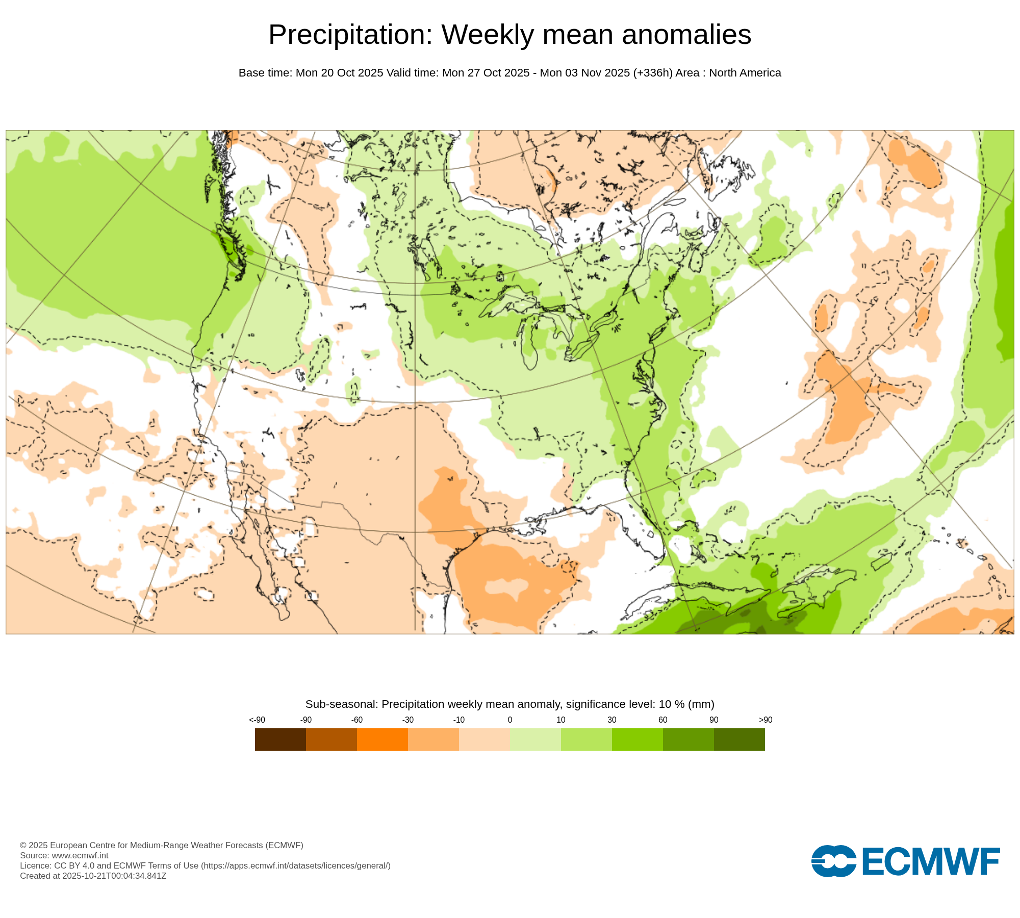
The latest CFS outlook has now shifted toward a wetter outcome for the close of October and start of November.
-
Yesterday saw a one-degree difference in high temperatures among Bridgeport, Islip, Central Park, JFK Airport, LaGuardia Airport, and White Plains for the second consecutive day. The last time that happened was February 14-15, 2014.
-
Yes. That kind of historic rainfall is very likely overdone. Not surprisingly, the 0z corrected toward lower amounts.
-
The idea of a potentially wet October 30-November 3 period, perhaps +/- a few days to allow for timing differences at the current forecasting range, still looks to be on track as per the latest ECMWF weekly guidance. It should be noted that the CFSv2 is still not on board. On the other hand, the 12z ECMWF has insane rainfall amounts in the Middle Atlantic Region.

-
Newark will probably approach or reach 70°. Most of the NYC area will probably fall just short.
-
Temperatures will top out in the lower and middle 60s through midweek. A stronger push of cold air could arrive afterward. Cool temperatures will likely persist through next weekend. The ENSO Region 1+2 anomaly was -0.4°C and the Region 3.4 anomaly was -0.6°C for the week centered around October 15. For the past six weeks, the ENSO Region 1+2 anomaly has averaged -0.15°C and the ENSO Region 3.4 anomaly has averaged -0.47°C. La Niña conditions will likely continue through mid-winter. The SOI was +7.60 today. The preliminary Arctic Oscillation (AO) was -1.132 today. Based on sensitivity analysis applied to the latest guidance, there is an implied 67% probability that New York City will have a warmer than normal October (1991-2020 normal). October will likely finish with a mean temperature near 58.6° (0.7° above normal). Supplemental Information: The projected mean would be 1.7° above the 1981-2010 normal monthly value.
-
2025-2026 ENSO
donsutherland1 replied to 40/70 Benchmark's topic in Weather Forecasting and Discussion
This is an exercise aimed at seeing if human subjectivity can be removed with an algorithm selecting analogs with a focus on the North American domain. More broadly, can analog development become an objective exercise. I don't know if that's possible right now. As noted in the discussion, I don't like one of the three that the algorithm chose (2011-12). I also include one (2024-25) that the algorithm did not choose. I will periodically post updates on this experiment. If there is merit in the algorithmic approach, one should see 500 mb patterns come more in line with the composite idea over 1- and, especially 3-month periods. The focus on this set is fall 2025 and winter 2025-26. That there is some similarity at 500 mb for winter 2025-2026 to the ECMWF forecast suggests that there's consensus on the boundary conditions and how the pattern might turn out. I don't believe the winter 500 mb idea from the experimental set precludes some intrusions of cold air into the CONUS during the winter, particularly the central U.S.