donsutherland1
-
Posts
23,988 -
Joined
Content Type
Profiles
Blogs
Forums
American Weather
Media Demo
Store
Gallery
Everything posted by donsutherland1
-
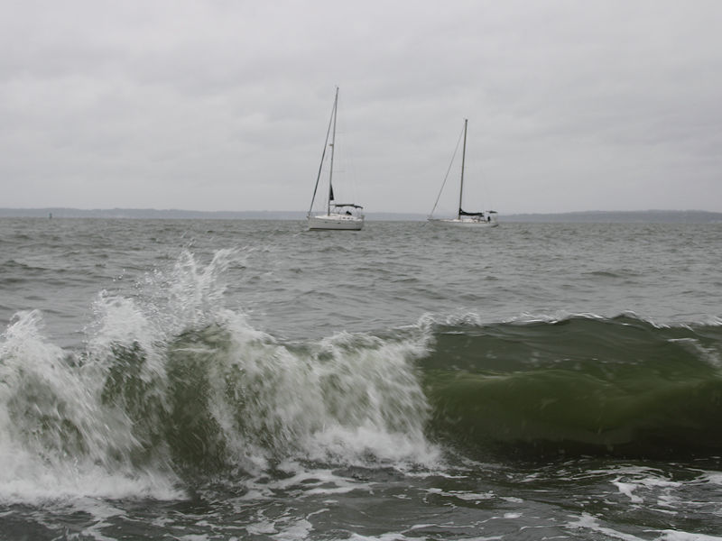
Two photos from late this afternoon from the Long Island Sound:

-
A nor'easter will continue to bring periods of rain and strong winds to the region into early Tuesday. A general 1"-3" rainfall is likely across the region with locally higher amounts. The wind will gust to 40 mph in New York City and its nearby suburbs, and 60 mph along portions of the Jersey Shore and eastern Long Island. Coastal flooding and beach erosion are likely. Following the nor'easter, a fresh shot of cool air will move into the region during the middle of next week. Some parts of the region could experience their coolest temperatures so far this fall. Dry conditions will likely prevail through the remainder of the week. In the 18 past years where Central Park saw at least two 80° or above highs and Newark saw at least two 84° or above highs during the first week of October, the temperature returned to 70° or above on at least one day during the second half of October in 17 (94.4%) of those cases. For all other cases, 84.1% saw at least one such high temperature during the second half of October. Therefore, the sharp cool spell very likely won't mean that New York City has seen its last 70° or above high temperature. The ENSO Region 1+2 anomaly was -0.1°C and the Region 3.4 anomaly was -0.5°C for the week centered around October 1. For the past six weeks, the ENSO Region 1+2 anomaly has averaged -0.15°C and the ENSO Region 3.4 anomaly has averaged -0.43°C. La Niña conditions will likely continue through mid-winter. The SOI was +8.31 today. The preliminary Arctic Oscillation (AO) was -0.008 today. Based on sensitivity analysis applied to the latest guidance, there is an implied 61% probability that New York City will have a warmer than normal October (1991-2020 normal). October will likely finish with a mean temperature near 58.8° (0.9° above normal). Supplemental Information: The projected mean would be 1.9° above the 1981-2010 normal monthly value.
-
While the New York City area waits as the nor'easter's rain spreads north and westward into the region, Phoenix has been having an incredibly wet day. It has seen hourly rainfall as high as 0.63" and has picked up 1.83" so far, today. Today is the fourth wettest October day on record there. The two-day figure of 2.53" is the second highest two-day amount on record. October records go back to 1895.
-
Hopefully, the flooding won't be so bad that it would affect the unraised homes.
- 731 replies
-
- 1
-

-
- heavy rain
- damaging wind
- (and 2 more)
-
Through October 10th, 2025 has the 3rd warmest start to October globally on the ERA-5 dataset. The five warmest October 1-10 periods are: 1. 15.72°C, 2023 2. 15.59°C, 2024 3. 15.45°C, 2025 4. 15.38°, 2015 5. 15.30°C, 2020 With the warm global forecast (generally 0.8°C-1.0°C) on the ECMWF weeklies, there is a growing chance that 2025 could join 2023 and 2024 as the only years with an October mean temperature of 15.00°C or above.
-
Steadier periods of rain will arrive tomorrow as a developing coastal nor'easter begins to affect the region. The wind will also pick up as the day wears on. Highs should reach the lower 60s tomorrow. The nor'easter will bring periods of rain and strong winds to the region into Tuesday. A general 1"-3" rainfall is likely across the region with locally higher amounts. The wind will gust to 40 mph in New York City and its nearby suburbs, and 60 mph along portions of the Jersey Shore and eastern Long Island. Coastal flooding and beach erosion are likely. Following the nor'easter, a fresh shot of cool air will move into the region during the middle of next week. Dry conditions will likely prevail through the remainder of the week. In the 18 past years where Central Park saw at least two 80° or above highs and Newark saw at least two 84° or above highs during the first week of October, the temperature returned to 70° or above on at least one day during the second half of October in 17 (94.4%) of those cases. For all other cases, 84.1% saw at least one such high temperature during the second half of October. Therefore, the sharp cool spell very likely won't mean that New York City has seen its last 70° or above high temperature. The ENSO Region 1+2 anomaly was -0.1°C and the Region 3.4 anomaly was -0.5°C for the week centered around October 1. For the past six weeks, the ENSO Region 1+2 anomaly has averaged -0.15°C and the ENSO Region 3.4 anomaly has averaged -0.43°C. La Niña conditions will likely continue through mid-winter. The SOI was +10.31 today. The preliminary Arctic Oscillation (AO) was +0.286 today. Based on sensitivity analysis applied to the latest guidance, there is an implied 62% probability that New York City will have a warmer than normal October (1991-2020 normal). October will likely finish with a mean temperature near 58.9° (1.0° above normal). Supplemental Information: The projected mean would be 2.0° above the 1981-2010 normal monthly value.
-
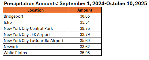
All of the major reporting sites around New York City have seen less than 40" of rain since September 1, 2024. The 1"-3" for NYC/nearby suburbs and 2"-4" on Long Island/Jersey Shore should help, but drier conditions will likely resume following the nor'easter.
-
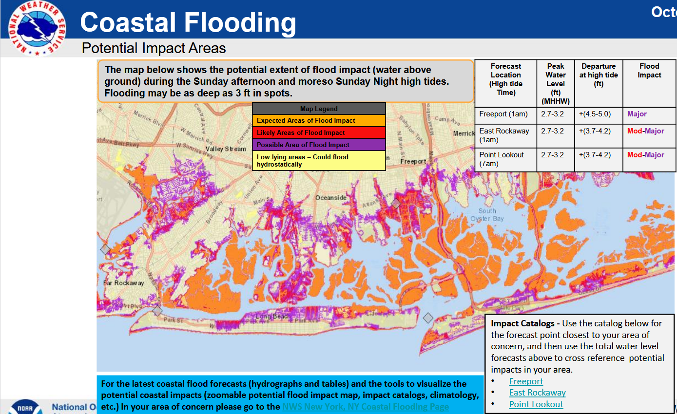
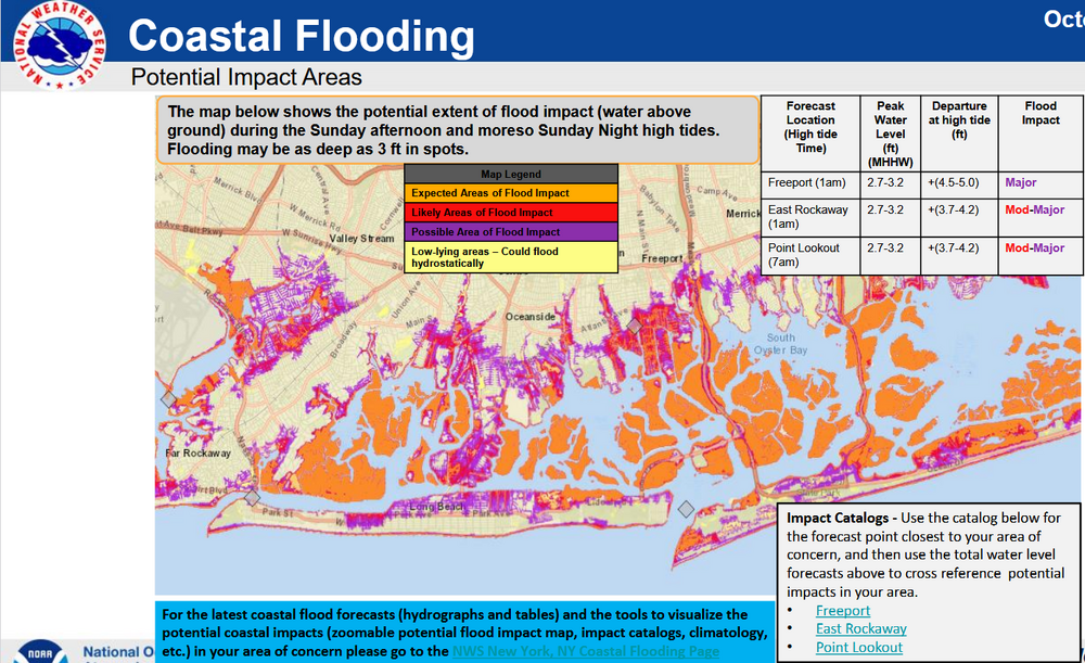
NWS forecast for most significant coastal flood impacts expected for Long Island:
- 731 replies
-
- 2
-

-
-
- heavy rain
- damaging wind
- (and 2 more)
-
Temperatures started out the day in the 30s and 40s across the region. The coldest spots saw readings drop into the upper 20s. Lows included: Albany: 31° Atlantic City: 40° Binghamton: 31° Boston: 41° Bridgeport: 40° Danbury: 31° Hartford: 29° Islip: 40° Montgomery: 26° (old record: 27°, 2000) New Haven: 39° New York City-Central Park: 46° New York City-JFK Airport: 43° New York City-LaGuardia Airport: 48° Newark: 41° Philadelphia: 45° Poughkeepsie: 28° Sussex: 29° Trenton: 39° Westhampton: 31° White Plains: 42° Temperatures will moderate during the weekend, but rain will arrive on Sunday. Highs should reach the middle and upper 60s tomorrow and lower and middle 60s on Sunday. A strong nor'easter will bring periods of rain and strong winds to parts of the region. Uncertainty as to amounts and locations of the heaviest rainfall has increased on the guidance, as a complex phasing situation is involved. For now, it still appears that a general 1"-3" rainfall is likely across New York City and its nearby suburbs, along with winds that will gust past 40 mph. Long Island could see 2"-4" of rain. Winds in this region could gust to 60 mph. There is the potential for lesser rainfall amounts along the Jersey Shore, but that is not yet certain. More revisions may be necessary after the overnight model cycles. A period of near normal to somewhat below normal temperatures and dry conditions will likely follow the nor-easter. In the 18 past years where Central Park saw at least two 80° or above highs and Newark saw at least two 84° or above highs during the first week of October, the temperature returned to 70° or above on at least one day during the second half of October in 17 (94.4%) of those cases. For all other cases, 84.1% saw at least one such high temperature during the second half of October. Therefore, the sharp cool spell very likely won't mean that New York City has seen its last 70° or above high temperature. The ENSO Region 1+2 anomaly was -0.1°C and the Region 3.4 anomaly was -0.5°C for the week centered around October 1. For the past six weeks, the ENSO Region 1+2 anomaly has averaged -0.15°C and the ENSO Region 3.4 anomaly has averaged -0.43°C. La Niña conditions will likely continue through mid-winter. The SOI was +18.82 today. The preliminary Arctic Oscillation (AO) was +1.044 today. Based on sensitivity analysis applied to the latest guidance, there is an implied 61% probability that New York City will have a warmer than normal October (1991-2020 normal). October will likely finish with a mean temperature near 58.9° (1.0° above normal). Supplemental Information: The projected mean would be 2.0° above the 1981-2010 normal monthly value.
-
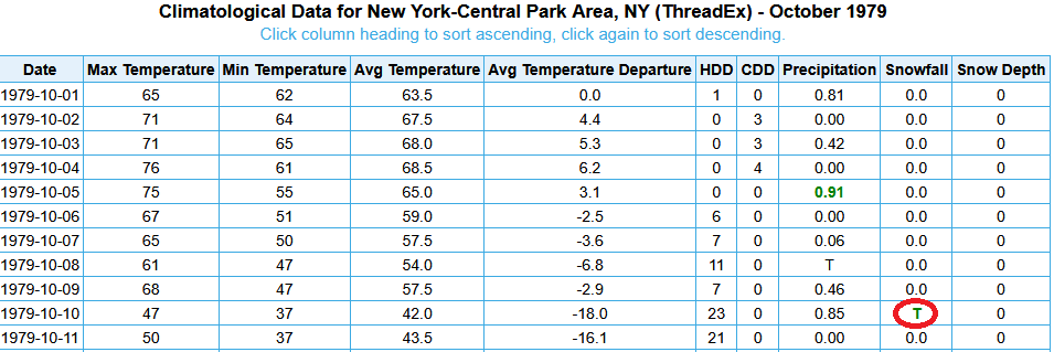
NYC had a trace of snow on October 10, 1979. The snow fell but didn't accumulate.
-
Yes it was.
-
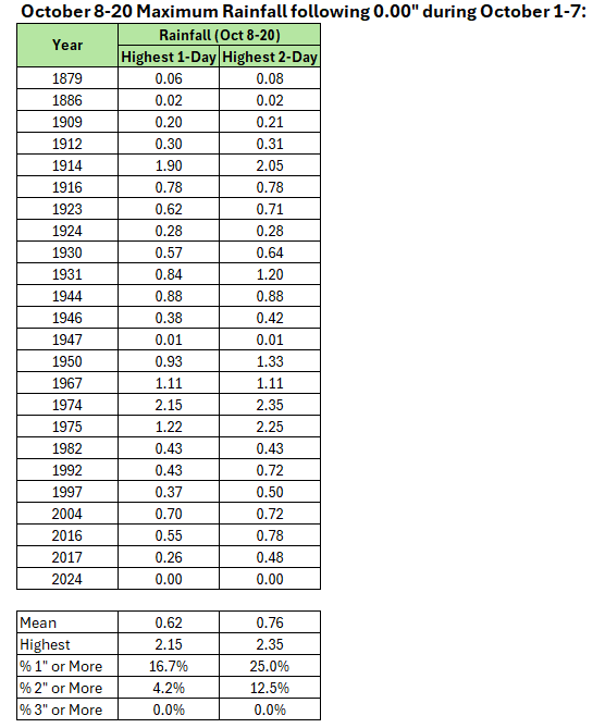
Looking at the dry start to October, the guidance had been showing what would be a fairly uncommon event. Perhaps, in retrospect, if rainfall amounts wind up becoming greatly reduced, the lesson is that until one is in the near range (< 3 days out), one should be skeptical of statistical outlier events, even when there is strong model support. The model support was based on the idea of a complex phasing situation, which, itself, is difficult for models to handle in the medium-range and beyond. A scenario concerning slower developing system that grazes the coastal plain (Long Island and eastern New England should still do well) is becoming more probable. We'll see what the later model runs show. For Central Park, here are the maximum one- and two-day rainfall events following a completely dry first week of October, as was the case this year. What still seems more certain is that the development of a drier pattern consistent with the development of an NAO-/AO- following the nor-easter remains on track.
- 731 replies
-
- 1
-
-
- heavy rain
- damaging wind
- (and 2 more)
-
2025-2026 ENSO
donsutherland1 replied to 40/70 Benchmark's topic in Weather Forecasting and Discussion
They're known for their hype. From last winter, here was one of their hyped long-range forecasts: https://www.americanwx.com/bb/topic/60046-2024-2025-la-nina/?do=findComment&comment=7582201 -
2025-2026 ENSO
donsutherland1 replied to 40/70 Benchmark's topic in Weather Forecasting and Discussion
Basically an ad. Teaser followed by 'buy my product/service.' -
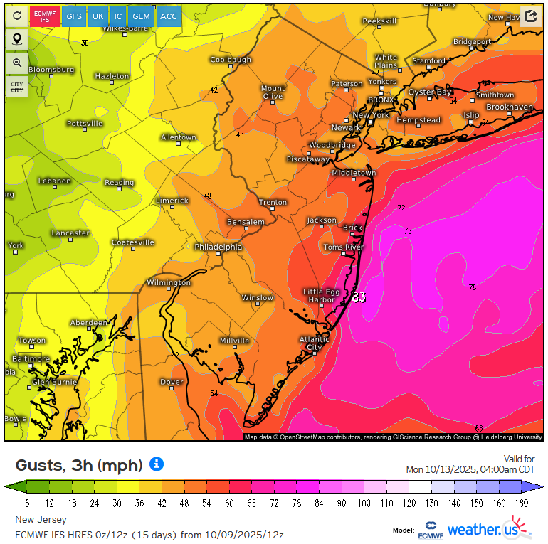
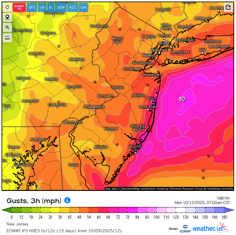
It still looks like this will be a weaker version of the October 2017 nor'easter. Heaviest rains will be 1"-3"/2"-4" with some locally higher amounts possible and winds gusting to 40 mph maybe near 60 mph in a few spots (not widespread). 2017 had far more widespread damaging winds and heavier rains. The PNS from that storm, which underwent bombogenesis (not likely this time around) is below: 285 NOUS41 KOKX 301850 PNSOKX CTZ005>012-NJZ002-004-006-103>108-NYZ067>075-078>081-176>179-310531- Public Information Statement...Corrected Spotter Reports National Weather Service New York NY 200 PM EDT Mon Oct 30 2017 The following are unofficial observations taken during the past 32 hours for the storm that has been affecting our region. Appreciation is extended to highway departments, cooperative observers, Skywarn spotters and media for these reports. This summary also is available on our home page at weather.gov/nyc ********************STORM TOTAL RAINFALL******************** LOCATION STORM TOTAL TIME/DATE COMMENTS RAINFALL OF /INCHES/ MEASUREMENT CONNECTICUT ...Fairfield County... Trumbull 5.44 530 AM 10/30 Trained Spotter 3 W New Canaan 5.21 1135 AM 10/30 CWOP Shelton 5.20 700 AM 10/30 Trained Spotter Stratford 5.19 1147 AM 10/30 CWOP Stamford 4.74 1146 AM 10/30 CWOP 1 NE Stamford 4.61 1130 AM 10/30 HADS 1 WNW Westport 4.48 1137 AM 10/30 CWOP Bethel 4.12 1004 PM 10/29 Emergency Manager Wilton 3.88 825 PM 10/29 Social Media Success Hill 3.82 700 AM 10/30 Co-Op Observer Sandy Hook 3.71 1005 PM 10/29 Social Media Bridgeport Airport 3.02 752 AM 10/30 ASOS 1 SSW Stamford 2.71 1136 AM 10/30 CWOP ...Middlesex County... Salmon River Nr East 4.81 1115 AM 10/30 GOES Clinton 4.54 338 AM 10/30 Broadcast Media Middletown 4w 3.13 1125 AM 10/30 HADS 2 NNE North Lyme 2.15 1057 PM 10/29 CWOP 1 NE Clinton 1.23 1146 AM 10/30 CWOP ...New Haven County... Waterbury Airport 5.49 751 AM 10/30 AWOS 1 E Seymour 5.49 1149 PM 10/29 CWOP Quinnipiac River 4.22 1100 AM 10/30 GOES 3 ESE Branford 3.58 600 AM 10/30 Trained Spotter Hamden 3.42 800 AM 10/30 Trained Spotter Cheshire 3.30 1045 PM 10/29 Trained Spotter Meriden Airport 3.25 753 AM 10/30 ASOS New Haven Airport 3.02 753 AM 10/30 ASOS 1 S Branford 2.96 1200 AM 10/30 CWOP ...New London County... 1 W North Lyme 5.01 1148 AM 10/30 CWOP New London 4.97 1148 AM 10/30 CWOP Waterford 4.44 1140 AM 10/30 CWOP Norwich 3.03 700 AM 10/30 Co-Op Observer Mystic 2.63 800 AM 10/30 Trained Spotter Groton Airport 2.59 756 AM 10/30 ASOS Pawcatuck 2.46 1157 PM 10/29 CWOP NEW JERSEY ...Bergen County... East Rutherford 5.10 1225 AM 10/30 Trained Spotter Westwood 5.02 1135 AM 10/30 CWOP Park Ridge 4.62 1127 AM 10/30 CWOP Garfield 4.15 1035 AM 10/30 Trained Spotter Oakland 3.44 930 AM 10/30 Trained Spotter Waldwick 3.25 945 PM 10/29 Trained Spotter Ridgewood 2.98 1000 PM 10/29 Trained Spotter Teterboro Airport 2.86 751 AM 10/30 ASOS ...Essex County... North Caldwell 5.20 1150 AM 10/30 CWOP Cedar Grove 4.10 1145 PM 10/29 Trained Spotter 1 SE Cedar Grove 3.22 1110 AM 10/30 CWOP ...Hudson County... Secaucus 4.60 1144 AM 10/30 CWOP Harrison 3.74 800 AM 10/30 AWS Harrison 3.55 243 AM 10/30 Trained Spotter ...Passaic County... 2 WNW Wayne 5.47 1147 AM 10/30 CWOP Hawthorne 5.37 1150 AM 10/30 CWOP 1 E Pompton Lakes 5.24 1141 AM 10/30 CWOP 3 NE West Milford 4.99 1149 AM 10/30 CWOP Bloomingdale 3.36 845 AM 10/30 Trained Spotter ...Union County... Newark Airport 4.08 751 AM 10/30 ASOS Linden Airport 2.77 155 AM 10/30 AWOS NEW YORK ...Kings County... 2 ENE Coney Island 5.19 1145 AM 10/30 CWOP Bay Ridge 4.79 1150 AM 10/30 CWOP 1 WNW Bay Ridge 4.15 1132 AM 10/30 CWOP Midwood 1.25 940 PM 10/29 Social Media 9 S Coney Island 2.76 800 AM 10/30 Trained Spotter ...Nassau County... 1 SW East Massapequa 5.03 1149 AM 10/30 CWOP Bellerose 4.57 900 AM 10/30 Trained Spotter Plainview 3.69 1030 PM 10/29 Trained Spotter Seaford 3.25 1054 PM 10/29 Social Media Wantagh 3.11 930 AM 10/30 Trained Spotter Merrick 2.98 900 AM 10/30 Broadcast Media ...New York County... Central Park 3.25 751 AM 10/30 ASOS ...Orange County... Gardnertown 5.43 1146 AM 10/30 CWOP Chester 4.84 1059 AM 10/30 CWOP 2 ESE Highland Mills 4.43 1130 PM 10/29 Trained Spotter Washingtonville 4.41 1150 AM 10/30 CWOP 1 SSW Newburgh 4.00 1143 AM 10/30 CWOP Monroe 2.92 530 AM 10/30 Trained Spotter Vails Gate 2.83 1130 PM 10/29 Trained Spotter Montgomery Airport 2.09 754 AM 10/30 ASOS ...Putnam County... Carmel 4n 3.16 810 AM 10/30 Co-Op Observer ...Queens County... 1 S Jackson Heights 5.57 1150 AM 10/30 CWOP Bellerose 4.36 451 AM 10/30 CWOP Astoria 4.00 1111 PM 10/29 CWOP NYC/JFK Airport 3.19 751 AM 10/30 ASOS NYC/La Guardia 2.89 751 AM 10/30 ASOS ...Richmond County... Greenbelt Propagatio 1.33 525 AM 10/30 Co-Op Observer ...Rockland County... Nanuet 5.95 1144 AM 10/30 CWOP Blauvelt 5.67 1142 AM 10/30 CWOP Sloatsburg 2.74 1138 AM 10/30 CWOP Mount Ivy 2.49 1120 AM 10/30 Co-Op Observer ...Suffolk County... 1 SW Deer Park 4.71 1035 PM 10/29 CWOP Rain Gage At Sag Har 4.54 1115 AM 10/30 GOES Riverhead 4.43 1100 AM 10/30 NWS Employee Sayville 4.40 930 PM 10/29 Public 1 E East Moriches 4.33 1118 PM 10/29 CWOP Farmingville 4.32 500 AM 10/30 Trained Spotter 1 ESE Copiague 4.32 1137 AM 10/30 CWOP 1 SE West Islip 4.11 754 AM 10/30 CWOP Brentwood 4.07 839 PM 10/29 Social Media Islip Airport 4.02 756 AM 10/30 ASOS Lake Ronkonkoma 3.99 1133 PM 10/29 Trained Spotter Medford 3.93 600 AM 10/30 Trained Spotter 1 W Sunken Meadow Pa 3.91 1150 AM 10/30 CWOP Shirley Airport 3.87 156 AM 10/30 ASOS Upton 3.79 800 AM 10/30 NWS Office Orient 3.78 1245 AM 10/30 Trained Spotter Nws New York 3.74 800 AM 10/30 Co-Op Observer 1 NNW Mattituck 3.72 1149 AM 10/30 CWOP Melville 3.72 1154 AM 10/30 CWOP Calverton 3.69 830 AM 10/30 NWS Employee Westhampton Airport 3.35 753 AM 10/30 ASOS S Baiting Hollow 3.19 700 AM 10/30 Co-Op Observer Southampton 3.05 815 AM 10/30 Trained Spotter Poquott 2.91 1149 AM 10/30 CWOP 1 E Asharoken 2.89 1151 AM 10/30 CWOP East Hampton 2.88 755 AM 10/30 AWOS Montauk Airport 2.68 754 AM 10/30 ASOS Farmingdale Airport 2.49 753 AM 10/30 ASOS Yaphank 2.24 853 PM 10/29 Trained Spotter Vanderbilt Museum 2.11 700 AM 10/30 Co-Op Observer ...Westchester County... Peekskill 5.12 1153 AM 10/30 CWOP 1 WSW Hawthorne 4.84 1148 AM 10/30 CWOP 1 ENE Eastchester 4.52 1139 AM 10/30 CWOP North Tarrytown 4.48 1142 AM 10/30 CWOP Somers 4.10 1015 PM 10/29 Social Media White Plains Airport 4.06 756 AM 10/30 ASOS 3 WNW Golden's Bridg 2.63 516 PM 10/29 Social Media **********************24 HOUR RAINFALL********************** LOCATION 24 HOUR TIME/DATE COMMENTS RAINFALL OF /INCHES/ MEASUREMENT CONNECTICUT ...Fairfield County... 2 SW Monroe 5.84 600 AM 10/30 CoCoRaHS 3 NW Monroe 5.77 800 AM 10/30 CoCoRaHS 1 ESE Newtown 5.41 1015 AM 10/30 CoCoRaHS 2 E Monroe 5.38 700 AM 10/30 CoCoRaHS Bethel 5.28 700 AM 10/30 CoCoRaHS 1 S Monroe 5.28 905 AM 10/30 CoCoRaHS 3 WSW Shelton 5.20 700 AM 10/30 CoCoRaHS 1 NNW Westport 4.97 759 AM 10/30 CWOP Bethel 4.81 757 AM 10/30 CWOP 4 WNW Newtown 4.64 700 AM 10/30 CoCoRaHS 5 SE Bedford 4.54 810 AM 10/30 CoCoRaHS 3 ESE Bethel 4.53 700 AM 10/30 CoCoRaHS 3 NNE Bethel 4.49 708 AM 10/30 CoCoRaHS 2 WSW Shelton 4.49 753 AM 10/30 CWOP 5 NE Danbury 4.34 745 AM 10/30 HADS 1 SSE Ridgefield 4.11 800 AM 10/30 CoCoRaHS 1 ENE New Canaan 4.03 800 AM 10/30 CoCoRaHS 2 W Danbury 3.91 754 AM 10/30 CWOP Success Hill 3.79 700 AM 10/30 Co-Op Observer Norwalk 2.9 NNW 3.75 700 AM 10/30 CoCoRaHS 1 ENE Norwalk 3.58 741 AM 10/30 CWOP Stratford 3.58 700 AM 10/30 CoCoRaHS 3 NNW Stamford 3.41 800 AM 10/30 CoCoRaHS 2 NW Darien 3.17 700 AM 10/30 CoCoRaHS 1 SE Shelton 3.14 758 AM 10/30 CWOP Rye Brook 3.06 752 AM 10/30 CWOP Bridgeport Airport 2.94 752 AM 10/30 ASOS Stratford 2.93 753 AM 10/30 CWOP 1 ENE Darien 2.90 845 AM 10/30 CoCoRaHS 1 NNW Stamford 2.74 755 AM 10/30 CoCoRaHS 3 W New Canaan 2.64 749 AM 10/30 CWOP 1 WNW Westport 2.52 1058 PM 10/29 CWOP Stamford 2.42 756 AM 10/30 CWOP 1 NE Stamford 2.41 730 AM 10/30 HADS 1 ENE Stamford 1.75 744 AM 10/30 CWOP 1 SSW Stamford 1.45 750 AM 10/30 CWOP 1 ENE Port Chester 0.92 700 AM 10/30 CoCoRaHS 1 W Trumbull 0.14 700 AM 10/29 CoCoRaHS 1 SW Shelton 0.13 740 AM 10/30 CWOP 2 ENE Fairfield 0.05 1146 AM 10/30 CWOP ...Middlesex County... Portland 4.30 800 AM 10/30 CoCoRaHS 1 SE Durham 4.07 1052 PM 10/29 CWOP 1 NE Westbrook 3.70 700 AM 10/30 CoCoRaHS Salmon River Nr East 2.45 715 AM 10/30 GOES 1 ENE Westbrook 2.43 700 AM 10/30 CoCoRaHS Middletown 4w 1.68 725 AM 10/30 HADS 2 NNE North Lyme 1.27 1057 PM 10/29 CWOP 1 NE Clinton 0.67 745 AM 10/30 CWOP 2 SE Killingworth 0.01 700 AM 10/29 CoCoRaHS ...New Haven County... 1 NNE Branford 6.03 735 AM 10/30 CWOP 1 SSE Oakville 5.53 751 AM 10/30 CWOP Waterbury Airport 5.28 751 AM 10/30 AWOS 3 SE Waterbury 5.14 700 AM 10/30 CoCoRaHS 2 WNW Naugatuck 4.68 753 AM 10/30 CWOP 1 NNW Naugatuck 4.50 745 AM 10/30 HADS 3 E Naugatuck 4.48 830 AM 10/30 CoCoRaHS 1 SE Milford 4.40 754 AM 10/30 CWOP 1 E Seymour 3.96 1149 PM 10/29 CWOP Prospect 1.9 ENE 3.93 600 AM 10/30 CoCoRaHS 1 W Madison 3.69 700 AM 10/30 CoCoRaHS North Haven 3.66 756 AM 10/30 CWOP 1 NE Naugatuck 3.63 630 AM 10/30 CoCoRaHS 2 SE Cheshire 3.61 700 AM 10/30 CoCoRaHS 2 WNW Wallingford 3.61 743 AM 10/30 CoCoRaHS 1 N Wallingford 3.58 635 AM 10/30 CoCoRaHS 3 NNW Wallingford 3.46 753 AM 10/30 CWOP 1 WNW Wallingford 3.35 700 AM 10/30 CoCoRaHS 2 ESE Cheshire 3.35 720 AM 10/30 CoCoRaHS 1 W Woodmont 3.22 700 AM 10/30 CoCoRaHS Meriden Airport 3.19 753 AM 10/30 ASOS 2 W Hamden 3.16 700 AM 10/30 CoCoRaHS 1 WNW Milford 3.15 1148 AM 10/30 CWOP 2 W Hamden 3.09 751 AM 10/30 CWOP New Haven Airport 3.02 753 AM 10/30 ASOS West Haven 2.50 700 AM 10/30 CoCoRaHS 1 S Branford 2.34 1200 AM 10/30 CWOP Quinnipiac River 2.26 700 AM 10/30 GOES ...New London County... Pendelton Hill Brook 3.92 1045 AM 10/30 GOES 3 E Salem 3.92 700 AM 10/30 CoCoRaHS 2 E Jewett City 3.37 430 AM 10/30 CoCoRaHS Norwich 3.03 700 AM 10/30 Co-Op Observer Yantic River (river 3.00 745 AM 10/30 ALERT Gales Ferry 2.85 700 AM 10/30 CoCoRaHS 2 NNE Norwich 2.81 530 AM 10/30 CoCoRaHS 1 W North Lyme 2.80 1148 AM 10/30 CWOP Groton Airport 2.59 756 AM 10/30 ASOS 3 SW Pawcatuck 2.57 800 AM 10/30 CoCoRaHS New London 2.54 746 AM 10/30 CWOP New London 2.52 730 AM 10/30 CoCoRaHS 3 E Mystic 2.38 700 AM 10/30 CoCoRaHS Mystic 2.28 700 AM 10/30 CoCoRaHS Waterford 2.27 750 AM 10/30 CWOP Pawcatuck 2.26 1157 PM 10/29 CWOP Waterford 0.97 1207 AM 10/30 CWOP NEW JERSEY ...Bergen County... Oakland 3.84 1115 AM 10/30 GOES North Arlington 3.71 850 AM 10/30 CoCoRaHS Allendale 3.65 740 AM 10/30 CWOP 1 SSE Franklin Lakes 3.64 745 AM 10/30 IFLOWS Oakland 3.60 800 AM 10/30 CoCoRaHS Midland Park 3.40 745 AM 10/30 IFLOWS Oakland 3.32 745 AM 10/30 CWOP 1 E Oakland 3.27 755 AM 10/30 CWOP 1 SE Fair Lawn 3.25 750 AM 10/30 CWOP Park Ridge 3.21 1100 AM 10/30 GOES Fair Lawn 3.12 749 AM 10/30 CWOP 1 W Tenafly 3.12 730 AM 10/30 CoCoRaHS Lodi 3.04 745 AM 10/30 IFLOWS Rochelle Park 3.03 645 AM 10/30 CoCoRaHS Bergenfield 2.97 752 AM 10/30 CWOP 1 E Westwood 2.95 730 AM 10/30 CoCoRaHS Hillsdale 2.87 715 AM 10/30 HADS Teterboro Airport 2.82 751 AM 10/30 ASOS Wood-ridge 2.79 753 AM 10/30 CWOP Teaneck 2.72 753 AM 10/30 CWOP Westwood 2.49 747 AM 10/30 CWOP River Edge 2.48 700 AM 10/30 CoCoRaHS Park Ridge 2.26 740 AM 10/30 CWOP Oakland 1.65 700 AM 10/30 CoCoRaHS ...Essex County... 1 NW Nutley 4.24 752 AM 10/30 CWOP Essex Fells 3.80 745 AM 10/30 Co-Op Observer 2 E Canoe Brook 3.80 1115 AM 10/30 Co-Op Observer Orange Reservoir 3.40 1100 AM 10/30 IFLOWS Maplewood 2.96 1100 AM 10/30 IFLOWS Maplewood 2.90 700 AM 10/30 CoCoRaHS North Caldwell 2.62 755 AM 10/30 CWOP 1 SE Cedar Grove 1.63 700 AM 10/30 CWOP ...Hudson County... Harrison 4.24 752 AM 10/30 CWOP Harrison 3.73 800 AM 10/30 AWS 1 WSW North Arlingto 3.73 800 AM 10/30 CWOP Harrison 3.73 800 AM 10/30 CoCoRaHS Hoboken 3.08 757 AM 10/30 CWOP Secaucus 2.30 755 AM 10/30 CWOP ...Passaic County... Little Falls 4.04 700 AM 10/30 CoCoRaHS Little Falls 4.02 800 AM 10/30 CoCoRaHS 1 E Ringwood 3.92 1110 AM 10/30 RAWS Ringwood 3.84 745 AM 10/30 Co-Op Observer Wanaque 3.76 1100 AM 10/30 Co-Op Observer Garret Mountain 3.64 745 AM 10/30 IFLOWS 1 W Totowa 3.60 745 AM 10/30 Co-Op Observer West Paterson 3.58 746 AM 10/30 CWOP 2 SE West Milford 3.55 700 AM 10/30 CoCoRaHS 2 NW Ringwood 3.36 745 AM 10/30 IFLOWS Wayne Twp 0.8 SSW 3.35 700 AM 10/30 CoCoRaHS Pompton Lakes Upper 3.34 730 AM 10/30 GOES West Milford 3.32 1045 AM 10/30 IFLOWS Passaic 3.16 742 AM 10/30 CWOP 2 WNW Wayne 2.76 747 AM 10/30 CWOP Hawthorne 2.70 800 AM 10/30 CWOP 1 E Pompton Lakes 2.64 741 AM 10/30 CWOP 3 NE West Milford 2.50 755 AM 10/30 CWOP Hawthorne 1.30 700 AM 10/30 CoCoRaHS ...Union County... Newark Airport 4.07 751 AM 10/30 ASOS Mountainside 3.99 730 AM 10/30 IFLOWS New Providence 3.80 730 AM 10/30 CoCoRaHS Scotch Plains 3.74 750 AM 10/30 CWOP Springfield 3.40 800 AM 10/30 CoCoRaHS 1 NNW Cranford 3.25 210 AM 10/30 CoCoRaHS Westfield 3.23 730 AM 10/30 CoCoRaHS Roselle 3.21 745 AM 10/30 CoCoRaHS Roselle Park 2.49 755 AM 10/30 CWOP NEW YORK ...Kings County... 1 SE Battery Park 2.97 700 AM 10/30 CoCoRaHS 2 ENE Coney Island 2.61 744 AM 10/30 CWOP Bay Ridge 2.43 755 AM 10/30 CWOP 1 WNW Bay Ridge 2.08 632 AM 10/30 CWOP ...Nassau County... Herricks 3.64 700 AM 10/30 CoCoRaHS Bellerose 3.63 700 AM 10/30 CoCoRaHS Searingtown 3.51 700 AM 10/30 CoCoRaHS Port Washington 3.48 750 AM 10/30 CoCoRaHS Thomaston 3.31 700 AM 10/30 CoCoRaHS Lynbrook 3.30 725 AM 10/30 CoCoRaHS Lynbrook 3.16 700 AM 10/30 CoCoRaHS 1 SSW Hicksville 3.11 743 AM 10/30 CWOP 1 E Uniondale 3.10 752 AM 10/30 CWOP 1 NNW East Massapequ 3.02 700 AM 10/30 CoCoRaHS 1 WNW Muttontown 2.97 753 AM 10/30 CWOP Locust Valley 2.95 900 AM 10/30 CoCoRaHS Farmingdale 2.94 749 AM 10/30 CWOP 1 E Jericho 2.92 700 AM 10/30 CoCoRaHS Plainedge 2.83 800 AM 10/30 CoCoRaHS Hewlett 2.67 751 AM 10/30 CWOP 1 SW East Massapequa 2.59 748 AM 10/30 CWOP Massapequa 2.55 830 AM 10/30 CoCoRaHS 1 SSE North Wantagh 2.42 715 AM 10/30 CoCoRaHS 1 ENE Hicksville 2.35 615 AM 10/30 CoCoRaHS Wantagh 2.15 800 AM 10/30 CoCoRaHS ...New York County... Central Park 3.16 751 AM 10/30 ASOS ...Orange County... West Point 4.41 655 AM 10/30 RAWS 3 NNE Millrift 3.29 1147 AM 10/30 CWOP Tuxedo 3.00 745 AM 10/30 Co-Op Observer New Windsor 2.94 751 AM 10/30 CWOP 3 WSW Pine Bush 2.86 900 AM 10/30 CoCoRaHS 3 W Warwick 2.85 700 AM 10/30 CoCoRaHS Gardnertown 2.74 746 AM 10/30 CWOP Chester 2.42 1059 AM 10/30 CWOP 1 S Walden 2.32 700 AM 10/30 CoCoRaHS Washingtonville 2.21 800 AM 10/30 CWOP Montgomery Airport 2.06 754 AM 10/30 ASOS 1 SSW Newburgh 2.02 753 AM 10/30 CWOP ...Putnam County... 2 WSW Mahopac 3.28 700 AM 10/30 CoCoRaHS 3 S Fishkill 3.21 655 AM 10/30 CoCoRaHS Carmel 4n 3.16 810 AM 10/30 Co-Op Observer 3 N Fahnestock State 3.10 530 AM 10/30 CoCoRaHS ...Queens County... Bellerose 3.81 451 AM 10/30 CWOP 2 NW Ozone Park 3.74 700 AM 10/30 CoCoRaHS Floral Park 3.61 730 AM 10/30 CWOP Whitestone 3.28 623 AM 10/30 CoCoRaHS NYC/JFK Airport 3.13 751 AM 10/30 ASOS Whitestone 2.97 756 AM 10/30 CWOP NYC/La Guardia 2.79 751 AM 10/30 ASOS 1 S Jackson Heights 2.75 750 AM 10/30 CWOP Astoria 2.38 1111 PM 10/29 CWOP ...Richmond County... 1 ENE Annadale 4.04 758 AM 10/30 CWOP 1 ENE Annadale 3.50 800 AM 10/30 CoCoRaHS Greenbelt Propagatio 1.27 525 AM 10/30 Co-Op Observer ...Rockland County... Montebello 3.84 730 AM 10/30 GOES Nanuet 3.45 730 AM 10/30 IFLOWS Nanuet 2.99 743 AM 10/30 CWOP 1 WSW West Nyack 2.82 700 AM 10/30 CoCoRaHS Blauvelt 2.81 741 AM 10/30 CWOP Sloatsburg 1.38 752 AM 10/30 CWOP Mount Ivy 1.22 720 AM 10/30 Co-Op Observer ...Suffolk County... 1 ESE Lake Grove 4.65 751 AM 10/30 CWOP 4 NE Calverton 4.59 800 AM 10/30 CWOP 1 SW North Patchogue 4.50 800 AM 10/30 CoCoRaHS 1 E Middle Island 4.31 800 AM 10/30 CWOP Farmingville 4.24 700 AM 10/30 CoCoRaHS Miller Place 4.22 744 AM 10/30 CWOP Lake Ronkonkoma 4.13 700 AM 10/30 CoCoRaHS Setauket-East Seta 4.12 1006 AM 10/30 CoCoRaHS 1 SE West Islip 3.99 754 AM 10/30 CWOP Nesconset Highway 3.96 600 AM 10/30 CoCoRaHS East Moriches 3.92 900 AM 10/30 CoCoRaHS Shirley Airport 3.86 756 AM 10/30 ASOS Sayville 3.83 700 AM 10/30 CoCoRaHS 1 WSW Commack 3.81 700 AM 10/30 CoCoRaHS Orient 3.79 754 AM 10/30 CWOP 1 ESE Dix Hills 3.78 753 AM 10/30 CWOP Islip Airport 3.77 756 AM 10/30 ASOS East Moriches 3.75 700 AM 10/30 CoCoRaHS Nws New York 3.74 800 AM 10/30 Co-Op Observer Commack 3.66 700 AM 10/30 CoCoRaHS 1 WNW Hauppauge 3.63 800 AM 10/30 CoCoRaHS 1 ESE Ridge 3.58 1159 PM 10/29 CoCoRaHS 3 NW Westhampton 3.55 701 AM 10/30 RAWS Carmans River 3.51 726 AM 10/30 RAWS Port Jefferson Stati 3.51 824 AM 10/30 CoCoRaHS Holtsville 3.48 800 AM 10/30 CoCoRaHS Jamesport 3.47 900 AM 10/30 CoCoRaHS Remsenburg-Speonk 3.45 700 AM 10/30 CoCoRaHS Centerport 3.40 800 AM 10/30 CoCoRaHS 1 E East Moriches 3.39 1118 PM 10/29 CWOP Farmingville 3.39 757 AM 10/30 CWOP Westhampton Airport 3.35 753 AM 10/30 ASOS Blue Point 3.32 800 AM 10/30 CoCoRaHS Patchogue 3.25 526 AM 10/30 CoCoRaHS Cutchogue 3.24 748 AM 10/30 CWOP 1 SW Deer Park 3.24 1035 PM 10/29 CWOP 1 ENE Kings Park 3.21 755 AM 10/30 CWOP Middle Country Road 3.21 750 AM 10/30 CWOP Bay Shore 3.21 700 AM 10/30 CoCoRaHS 1 SSE Sayville 3.20 700 AM 10/30 CoCoRaHS Baiting Hollow 3.19 700 AM 10/30 Co-Op Observer 1 ESE Islandia 3.16 730 AM 10/30 CoCoRaHS Blue Point 3.15 742 AM 10/30 CWOP 1 SSW Nesconset 3.13 817 AM 10/30 CoCoRaHS Brightwaters 3.12 700 AM 10/30 CoCoRaHS 1 WSW Smithtown 3.09 754 AM 10/30 CWOP 2 NW West Islip 2.98 752 AM 10/30 CWOP 2 S Brookhaven Natio 2.94 600 AM 10/30 CoCoRaHS East Hampton 2.88 755 AM 10/30 AWOS 1 E Asharoken 2.86 800 AM 10/30 CoCoRaHS Greenlawn 2.77 750 AM 10/30 CWOP West Islip 2.71 735 AM 10/30 CoCoRaHS 1 S Hampton Bays 2.67 746 AM 10/30 CWOP Copiague 2.65 800 AM 10/30 CoCoRaHS Islip Terrace 2.65 830 AM 10/30 CoCoRaHS Amityville 2.63 732 AM 10/30 CoCoRaHS 1 WSW Fishers Island 2.61 700 AM 10/30 CoCoRaHS Amityville 2.61 915 AM 10/30 CoCoRaHS Montauk Airport 2.53 754 AM 10/30 ASOS 1 ENE Hampton Bays 2.47 752 AM 10/30 CWOP Rain Gage At Sag Har 2.30 715 AM 10/30 GOES Farmingdale Airport 2.27 753 AM 10/30 ASOS 1 ESE Copiague 2.20 751 AM 10/30 CWOP 1 W Sunken Meadow Pa 2.18 750 AM 10/30 CWOP Vanderbilt Museum 2.11 700 AM 10/30 Co-Op Observer 1 NNW Mattituck 2.03 901 PM 10/29 CWOP Mastic Beach 1.90 749 AM 10/30 CWOP Melville 1.90 754 AM 10/30 CWOP ...Westchester County... 3 NNE Briarcliff Man 4.69 750 AM 10/30 CWOP Armonk 4.68 815 AM 10/30 CoCoRaHS Armonk 4.64 753 AM 10/30 CWOP Armonk 4.40 746 AM 10/30 CWOP 1 NE Irvington 3.95 752 AM 10/30 CWOP White Plains Airport 3.75 756 AM 10/30 ASOS Yorktown Heights 3.50 800 AM 10/30 CoCoRaHS 1 WSW Armonk 3.25 745 AM 10/30 CWOP Peekskill 0.4 N 2.85 800 AM 10/30 CoCoRaHS Peekskill 2.48 753 AM 10/30 CWOP 1 WSW Hawthorne 2.41 748 AM 10/30 CWOP North Tarrytown 2.27 743 AM 10/30 CWOP 1 ENE Eastchester 2.23 753 AM 10/30 CWOP ***********************PEAK WIND GUST*********************** LOCATION MAX WIND TIME/DATE COMMENTS GUST OF MPH MEASUREMENT CONNECTICUT ...Fairfield County... Stamford 65 136 AM 10/30 CWOP 1 SSW Stamford 64 1134 PM 10/29 CWOP Old Greenwich 64 1040 PM 10/29 Social Media 1 SE Bridgeport 58 1130 PM 10/29 NOS-NWLON 2 ENE Fairfield 57 129 AM 10/30 CWOP Bridgeport Airport 54 1152 PM 10/29 ASOS 1 ENE Norwalk 32 1225 AM 10/30 CWOP 3 SE Bethel 30 1101 AM 10/30 CWOP ...Middlesex County... 2 NNE North Lyme 37 1007 PM 10/29 CWOP 1 NE Clinton 31 1128 PM 10/29 CWOP ...New Haven County... Meriden Airport 56 106 AM 10/30 ASOS Madison 54 125 AM 10/30 WXFLOW New Haven Airport 54 1102 PM 10/29 ASOS 2 SSE New Haven 47 1218 AM 10/30 NOS-PORTS Waterbury Airport 46 1151 PM 10/29 AWOS 1 WNW Milford 46 1235 AM 10/30 CWOP 3 SW East Haven 45 1115 PM 10/29 WXFLOW 2 W Hamden 35 1131 PM 10/29 CWOP 1 NNE Branford 30 1035 PM 10/29 CWOP ...New London County... 4 ESE Mystic 73 240 AM 10/30 WXFLOW Groton Airport 66 1131 PM 10/29 ASOS Groton 66 1111 PM 10/29 ASOS 1 NNE New London 58 139 AM 10/30 WXFLOW New London 47 1236 AM 10/30 NOS-NWLON Pawcatuck 46 1157 PM 10/29 CWOP 3 NNW Niantic 45 203 AM 10/30 CWOP New London 39 159 AM 10/30 CWOP Waterford 36 230 AM 10/30 CWOP 1 W North Lyme 34 103 PM 10/30 CWOP 3 ESE North Lyme 32 100 AM 10/30 CWOP New London 30 802 AM 10/30 CWOP NEW JERSEY ...Bergen County... Teterboro Airport 43 1135 PM 10/29 ASOS Haworth 38 125 AM 10/30 NJWXNET Wood-ridge 37 204 AM 10/30 CWOP 1 SE Fair Lawn 34 1200 AM 10/30 CWOP Allendale 31 1256 PM 10/30 CWOP Oakland 31 205 AM 10/30 CWOP ...Hudson County... 1 ENE Bayonne 44 1140 PM 10/29 WXFLOW Hoboken 33 1202 AM 10/30 CWOP Jersey City 32 1225 AM 10/30 NJWXNET 1 WSW North Arlingto 31 1200 PM 10/30 CWOP ...Passaic County... Passaic 42 110 AM 10/30 CWOP 3 ENE West Milford 39 1124 AM 10/30 NONFEDAWOS 2 ENE Green Pond 36 845 AM 10/30 NJWXNET Hawthorne 32 140 AM 10/30 CWOP Hawthorne 30 135 AM 10/30 NJWXNET ...Union County... Newark Airport 48 151 AM 10/30 ASOS Linden Airport 43 1235 PM 10/30 AWOS NEW YORK ...Kings County... 1 SSE Battery Park 43 326 AM 10/30 CWOP Bay Ridge 35 1235 PM 10/30 CWOP 2 ENE Coney Island 34 1230 PM 10/30 CWOP ...Nassau County... Merrick 51 1050 PM 10/29 Broadcast Media 2 NNE Glen Cove 51 1241 PM 10/30 WXFLOW 2 E Lido Beach 49 1038 AM 10/30 WXFLOW 1 SE Syosset 46 1040 PM 10/29 NONFEDAWOS Wantagh 45 130 AM 10/30 NYSM 1 WNW Muttontown 41 1138 PM 10/29 CWOP Bethpage 40 1133 PM 10/29 NONFEDAWOS 1 SW East Massapequa 40 1132 PM 10/29 CWOP Wantagh 37 1108 PM 10/29 CWOP 1 E Uniondale 34 1053 AM 10/30 CWOP Hewlett 33 1236 PM 10/30 CWOP Farmingdale 32 103 AM 10/30 CWOP ...New York County... Central Park 36 151 AM 10/30 ASOS ...Orange County... Montgomery Airport 46 154 AM 10/30 ASOS Stewart Airport 46 1145 AM 10/30 AWOS 1 WSW Montgomery 44 215 AM 10/30 NONFEDAWOS 2 WSW Warwick 42 230 AM 10/30 NYSM Gardnertown 36 951 AM 10/30 CWOP West Point 36 955 AM 10/30 RAWS 2 ENE Otisville 34 930 AM 10/30 NYSM New Windsor 32 906 AM 10/30 CWOP Chester 30 1207 PM 10/30 CWOP ...Queens County... NYC/La Guardia 49 1151 PM 10/29 ASOS 1 S Jackson Heights 47 135 AM 10/30 CWOP NYC/JFK Airport 46 1051 PM 10/29 ASOS 2 WSW Rockaway Beach 45 1219 AM 10/30 WXFLOW Whitestone 30 1203 AM 10/30 CWOP ...Rockland County... Viola 39 1250 PM 10/30 NYSM ...Suffolk County... 3 ENE Plum Island 75 210 AM 10/30 WXFLOW Anoemometer Height 53 ft. Captree State Park 67 1109 PM 10/29 WXFLOW 3 SE Hampton Bays 67 1135 PM 10/29 WXFLOW Montauk 67 1215 AM 10/30 Trained Spotter 2 W Hither Hills Sta 64 206 AM 10/30 WXFLOW 2 WSW Fishers Island 64 130 AM 10/30 WXFLOW Babylon 63 1019 PM 10/29 Social Media 2 SW Mastic Beach 63 841 PM 10/29 WxFlow 1 E Belle Terre 60 1105 PM 10/29 WXFLOW 1 SW Montauk 59 1147 PM 10/29 CWOP 1 ESE Copiague 59 1204 AM 10/30 CWOP 2 WNW Captree State 57 1224 AM 10/30 WXFLOW Orient 56 139 AM 10/30 CWOP Islip 56 1149 PM 10/29 ASOS Eatons Neck 56 940 AM 10/30 WXFLOW 1 S Blue Point 54 1245 AM 10/30 WXFLOW 1 SE Amityville 54 1110 PM 10/29 WXFLOW 1 S Brookhaven 54 1257 AM 10/30 CWOP 1 SSE East Moriches 54 1022 PM 10/29 WXFLOW Farmingdale Airport 53 1053 PM 10/29 ASOS 4 NE Calverton 51 110 PM 10/30 CWOP Islip Airport 51 956 PM 10/29 ASOS 1 ENE Montauk Highwa 51 741 AM 10/30 WXFLOW Shirley Airport 49 1028 PM 10/29 ASOS Westhampton Airport 48 1122 PM 10/29 ASOS East Hampton 48 1055 PM 10/29 AWOS 1 ENE Ocean Beach 47 1030 PM 10/29 WXFLOW Montauk Airport 45 954 PM 10/29 ASOS 1 SE West Islip 45 1104 PM 10/29 CWOP Peconic 45 150 AM 10/30 NYSM Miller Place 44 1128 PM 10/29 CWOP 1 E East Moriches 41 832 AM 10/30 CWOP Cutchogue 41 1203 AM 10/30 CWOP 1 E Middle Island 40 110 PM 10/30 CWOP Greenlawn 38 1230 AM 10/30 CWOP 1 E Asharoken 37 1136 PM 10/29 CWOP Cutchogue 37 133 AM 10/30 CWOP Middle Country Road 36 850 AM 10/30 CWOP Blue Point 35 557 AM 10/30 CWOP Farmingville 35 1137 PM 10/29 CWOP 1 WSW Smithtown 33 1023 PM 10/29 CWOP 1 NNW Mattituck 32 901 PM 10/29 CWOP 2 NW West Islip 31 1232 AM 10/30 CWOP 3 NW Westhampton 31 1101 PM 10/29 RAWS 1 ENE Kings Park 30 1224 AM 10/30 CWOP Mastic Beach 30 1236 AM 10/30 CWOP ...Westchester County... 1 SSW Mamaroneck 57 1236 AM 10/30 WXFLOW 1 SSW Ossining 53 1243 AM 10/30 WXFLOW White Plains Airport 44 119 AM 10/30 ASOS Croton-on-hudson 43 1238 PM 10/30 WXFLOW Peekskill 35 703 AM 10/30 CWOP 1 ENE Eastchester 34 1052 PM 10/29 CWOP Hastings-on-hudson 30 937 PM 10/29 CWOP 1 WSW Hawthorne 30 1108 PM 10/29 CWOP Armonk 30 1100 PM 10/29 CWOP ***********************SUSTAINED WIND*********************** LOCATION WIND TIME/DATE COMMENTS SPEED OF MPH MEASUREMENT CONNECTICUT ...Fairfield County... Bridgeport Airport 38 1131 PM 10/29 ASOS 2 SW Bridgeport 28 804 AM 10/30 AWS ...Middlesex County... Fenwick 39 1045 PM 10/29 HADS ...New Haven County... 4 E Beacon Falls 51 650 AM 10/29 AWS New Haven Airport 39 1151 PM 10/29 ASOS ...New London County... Groton Airport 48 1148 PM 10/29 ASOS Jewett City 27 1129 PM 10/29 AWS NEW JERSEY ...Bergen County... Englewood Cliffs 34 204 AM 10/30 URBANET ...Hudson County... Jersey City 31 745 AM 10/30 NJWXNET Weehawken 27 104 PM 10/30 URBANET Harrison 26 933 PM 10/29 URBANET ...Union County... 1 SSW Hillside 28 1139 AM 10/30 CWOP NEW YORK ...Kings County... 1 ENE Bay Ridge 38 204 AM 10/30 URBANET Coney Island 30 405 PM 10/29 URBANET Bay Ridge 29 1154 PM 10/29 URBANET 1 W Flatbush 28 1234 PM 10/30 URBANET Flatbush 28 104 PM 10/30 URBANET ...New York County... New York 32 1226 AM 10/30 CWOP ...Queens County... NYC/JFK Airport 38 1131 PM 10/29 ASOS 1 SSW Bayside 38 1133 AM 10/30 URBANET NYC/La Guardia 35 1151 PM 10/29 ASOS ...Richmond County... New Dorp 27 1124 AM 10/30 URBANET ...Suffolk County... Farmingdale Airport 41 1041 PM 10/29 ASOS Islip Airport 41 1044 PM 10/29 ASOS Westhampton Airport 32 1123 PM 10/29 ASOS Shirley Airport 31 1029 PM 10/29 ASOS 1 SW Montauk 31 1218 PM 10/30 CWOP Ronkonkoma 27 929 AM 10/30 AWS ...Westchester County... Mamaroneck 29 1150 PM 10/29 AWS
- 731 replies
-
- 4
-
-
-
- heavy rain
- damaging wind
- (and 2 more)
-
Yes, we're definitely out of the full moon phase. At least that's something certain while the models still try to refine things.
- 731 replies
-
- 3
-
-
- heavy rain
- damaging wind
- (and 2 more)
-
It was likely the combination of thick fresh snow cover and strong radiational cooling that produced the subzero November temperatures in 1938.
-
Montgomery: 28.
-
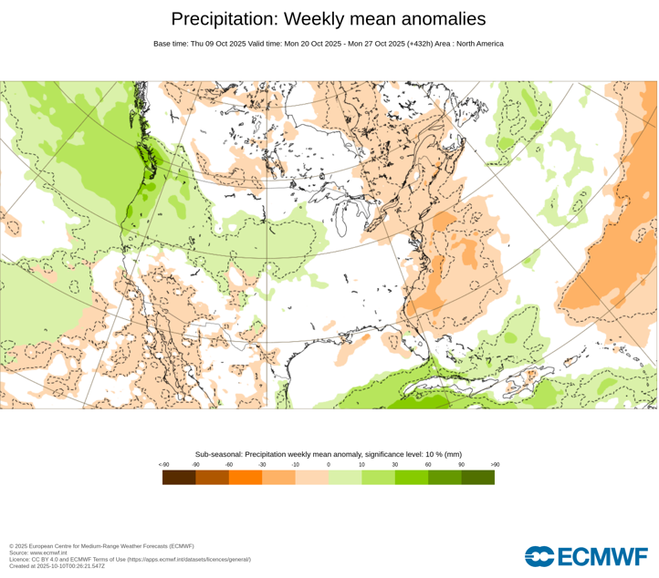
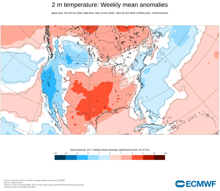
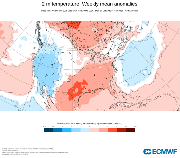
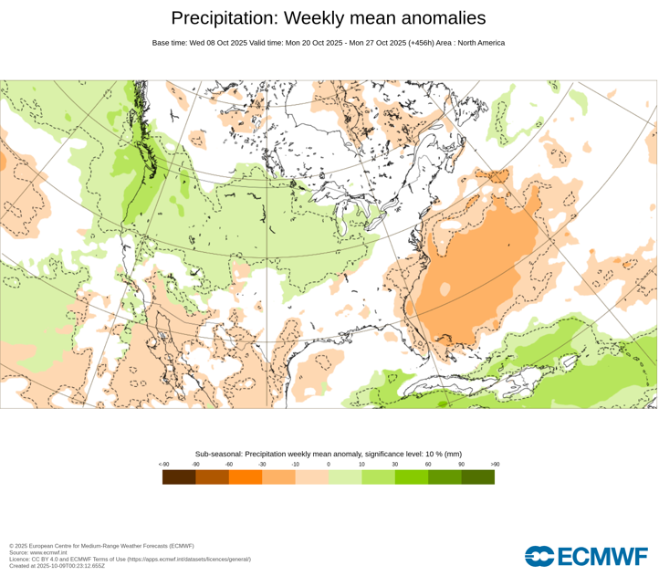
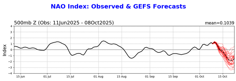
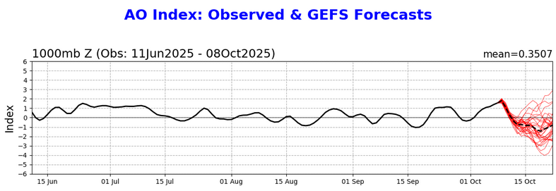
Consistent with strong NAO- and AO- combinations during the second half of October, the latest ECWMF weekly forecast now shows a cooler and drier period following the upcoming nor'easter. The latest ECMWF weekly guidance is below.
-
The coolest air mass so far this season covers the region. Today's high temperature of 59° at Central Park was the coolest high temperature since May 22 when the high was just 51°. Tonight will be unseasonably cool with the temperature falling into the middle and upper 40s in New York City. The last time New York City saw the temperature dip below 50° was May 24 when the low was 48°. Many areas outside the City will see readings bottom out in the 30s. Temperatures will moderate during the weekend, but rain will arrive on Sunday. A strong nor'easter will bring periods of rain and strong winds to the region, with the highest rainfall amounts and strongest gusts likely for the Jersey Shore and parts of Long Island. Coastal flooding and beach erosion are likely. A general 1"-3" rainfall is likely across New York City and its nearby suburbs, along with winds that will gust past 40 mph. Long Island and the Jersey Shore will see 2"-4" of rain with locally higher amounts of up to 6". Winds in this region could gust to 60 mph. In the 18 past years where Central Park saw at least two 80° or above highs and Newark saw at least two 84° or above highs during the first week of October, the temperature returned to 70° or above on at least one day during the second half of October in 17 (94.4%) of those cases. For all other cases, 84.1% saw at least one such high temperature during the second half of October. Therefore, the sharp cool spell very likely won't mean that New York City has seen its last 70° or above high temperature. The ENSO Region 1+2 anomaly was -0.1°C and the Region 3.4 anomaly was -0.5°C for the week centered around October 1. For the past six weeks, the ENSO Region 1+2 anomaly has averaged -0.15°C and the ENSO Region 3.4 anomaly has averaged -0.43°C. La Niña conditions will likely develop during mid- or late-autumn. The SOI was +21.92 today. The preliminary Arctic Oscillation (AO) was +1.782 today. Based on sensitivity analysis applied to the latest guidance, there is an implied 59% probability that New York City will have a warmer than normal October (1991-2020 normal). October will likely finish with a mean temperature near 58.9° (1.0° above normal). Supplemental Information: The projected mean would be 2.0° above the 1981-2010 normal monthly value.
-
Here you go:
-
Perhaps a less intense version of the October 29-30, 2017 nor'easter, at least in terms of impacts.
-
It increasingly appears that a powerful nor'easter that will be cut off will bring a prolonged period of rain to the New York City area, along with gusty winds, coastal flooding, and beach erosion. New York City appears to be in line for 1" to perhaps 3" of total rainfall with 2" to perhaps 4" likely for parts of Long Island. There remains some uncertainty concerning the upper part of the range. Parts of the Jersey Shore and Delmarva could see an area of 3"-6" of rain. The 10/9 12z NBE offers a reasonable starting point while the guidance refines the amounts in coming days. Select NBE Amounts: October 11-15: Atlantic City: 4.29" Belmar: 3.48" Boston: 3.54" Bridgeport: 3.04" Farmingdale: 3.15" Islip: 3.41" New Haven: 3.04" New York City-Central Park: 2.71" New York City-JFK Airport: 3.20" New York City-Laguardia Airport: 2.80" Newark: 2.72" Philadelphia: 2.61" Poughkeepsie: 2.03" Salisbury: 4.31" Westhampton: 3.83" White Plains: 2.88" Afterward, the NAO is forecast to plunge below -1.000 while the AO also goes negative. Such blocking is typically associated with cooler and much drier conditions than would otherwise be the case. ECMWF Weekly Forecasts: October 13-20: ECMWF Weekly Forecasts: October 20-27: The latest CFSv2 weekly forecasts show drier conditions developing following the nor'easter. However, the CFSv2 is much more aggressive in bringing back the warmth. I suspect that the ECMWF weeklies may have a better idea based on the latest teleconnections forecast. That's not an especially cold outlook, but it would fit the experience with the teleconnections and the fact that the coldest air in the Northern Hemisphere is not available to be tapped when the period of blocking develops. Finally, one or more highs of 70° during the second half of October are probably more likely than not given climatology and past cases following a very warm first week of the month.
-
A shot of much cooler air is moving into the region. Central Park will likely see its first lows in the 40s this season either tomorrow morning or Friday morning. Temperatures will moderate during the weekend. A potential nor'easter will need to be watched for late in the weekend to early next week. This storm could bring some periods of rain and gusty winds to parts of the region, with the highest rainfall amounts and strongest gusts likely for the Jersey Shore and parts of Long Island. Coastal flooding is possible. In the 18 past years where Central Park saw at least two 80° or above highs and Newark saw at least two 84° or above highs during the first week of October, the temperature returned to 70° or above on at least one day during the second half of October in 17 (94.4%) of those cases. For all other cases, 84.1% saw at least one such high temperature during the second half of October. Therefore, the sharp cool spell very likely won't mean that New York City has seen its last 70° or above high temperature. The ENSO Region 1+2 anomaly was -0.1°C and the Region 3.4 anomaly was -0.5°C for the week centered around October 1. For the past six weeks, the ENSO Region 1+2 anomaly has averaged -0.15°C and the ENSO Region 3.4 anomaly has averaged -0.43°C. La Niña conditions will likely develop during mid- or late-autumn. The SOI was +4.38 today. The preliminary Arctic Oscillation (AO) was +1.649 today. Based on sensitivity analysis applied to the latest guidance, there is an implied 61% probability that New York City will have a warmer than normal October (1991-2020 normal). October will likely finish with a mean temperature near 59.1° (1.2° above normal). Supplemental Information: The projected mean would be 2.2° above the 1981-2010 normal monthly value.