donsutherland1
-
Posts
23,988 -
Joined
Content Type
Profiles
Blogs
Forums
American Weather
Media Demo
Store
Gallery
Everything posted by donsutherland1
-
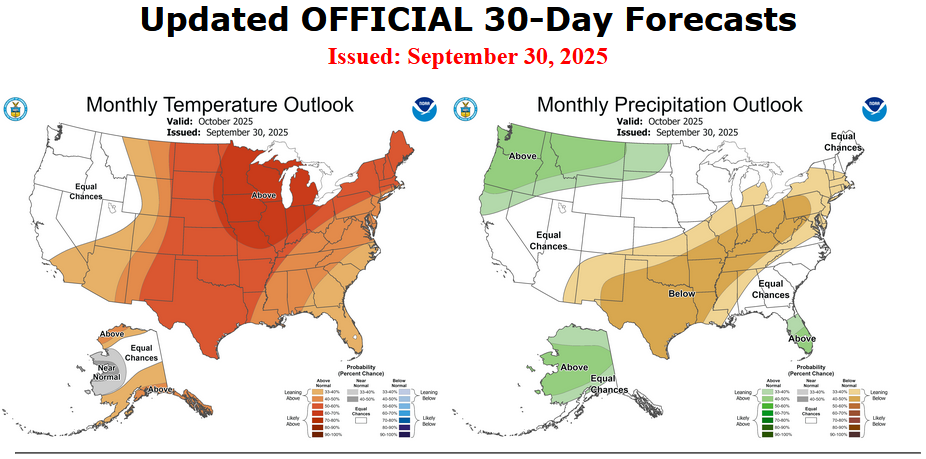
The final CPC October 2025 Outlooks:
-
September 2025 OBS-Discussion centered NYC subforum
donsutherland1 replied to wdrag's topic in New York City Metro
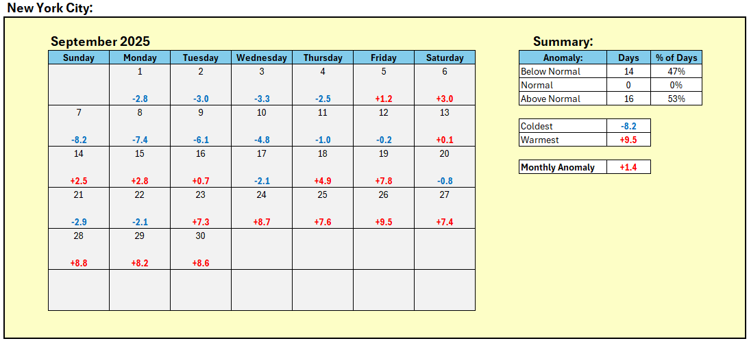
Final September mean temperature in New York City: 70.6° September 2025 had the second smallest standard deviation in temperatures for any September. Lowest Standard Deviations: 1. 1968 3.43° 2. 2025 3.63° 3. 1870 3.81° 4. 2024 3.94° 5. 1908 4.08° Standard Deviations in the New York City Area: Bridgeport: 3.60° (old record: 3.72°, 2024) Islip: 4.11° (3rd lowest) New York City-Central Park: 3.63° (2nd lowest) New York City-JFK Airport: 3.64° (2nd lowest) New York City-LaGuardia Airport: 3.82° (2nd lowest) Newark: 4.19° (3rd lowest) White Plains: 4.02° (old record: 4.28°, 1968)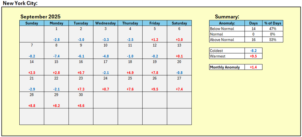
-
September 2025 OBS-Discussion centered NYC subforum
donsutherland1 replied to wdrag's topic in New York City Metro
I thought I had included the 1895 but typed too fast. The 1914 heatwave tied the 1895 one for the latest on record at Central Park. -
September 2025 OBS-Discussion centered NYC subforum
donsutherland1 replied to wdrag's topic in New York City Metro
The latest heatwave on record for Central Park is September 21-23, 1895 and 1914. Newark's is September 23-25, 2017. -
September 2025 OBS-Discussion centered NYC subforum
donsutherland1 replied to wdrag's topic in New York City Metro
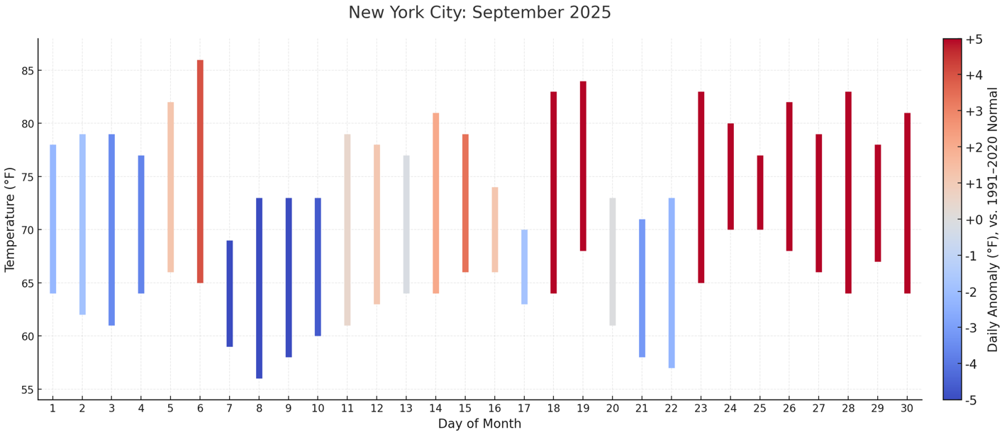
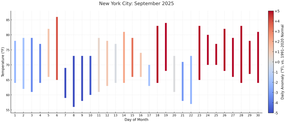
September is ending on an unseasonably warm note. Many parts of the region saw high temperatures in the 80s. Preliminary highs included: Bridgeport: 81° Islip: 82° (tied record set in 1986) New York City-Central Park: 81° New York City-JFK Airport: 81° New York City-LaGuardia Airport: 80° Newark: 83° White Plains: 80° The last time all seven locations saw 80° or above highs on September 30th was in 1986. The start of October will coincide with arrival of the coolest air mass so far this season, but temperatures will likely quickly moderate, rising to above normal levels within a few days. High temperatures will reach only the middle 60s tomorrow and Thursday. New York City will see the low temperature bottom out in the lower 50s on Thursday morning. Outside the City, widespread 40s are likely with a few of the colder locations dipping into the 30s. A rapid warmup will commence on Friday and a warm weekend lies ahead. The guidance and historical experience following a second half September mean temperature of 70° or above suggest that October will be warmer than normal in the New York City area. The two most recent Octobers with a cooler than normal first half like 2025 and a second half with a mean temperature of 70° or above were: 2017 (October mean temperature: 64.1° and October 2019: October mean temperature 59.9°). The ENSO Region 1+2 anomaly was -0.1°C and the Region 3.4 anomaly was -0.5°C for the week centered around September 24. For the past six weeks, the ENSO Region 1+2 anomaly has averaged -0.12°C and the ENSO Region 3.4 anomaly has averaged -0.42°C. La Niña conditions will likely develop during mid- or late-autumn. The SOI was +3.63 today. The preliminary Arctic Oscillation (AO) was -0.436 today. -
September 2025 OBS-Discussion centered NYC subforum
donsutherland1 replied to wdrag's topic in New York City Metro
Islip has reached 82°. That ties the daily record for September 30th that was set in 1986. -
September 2025 OBS-Discussion centered NYC subforum
donsutherland1 replied to wdrag's topic in New York City Metro
Newark has reached 80° for the 10th time during the second half of September. That is tied with September 1881 for the second most such days and just one short of the record of 11 days from 2017. -
Winter cancelled/uncancelled banter 25/26
donsutherland1 replied to Rjay's topic in New York City Metro
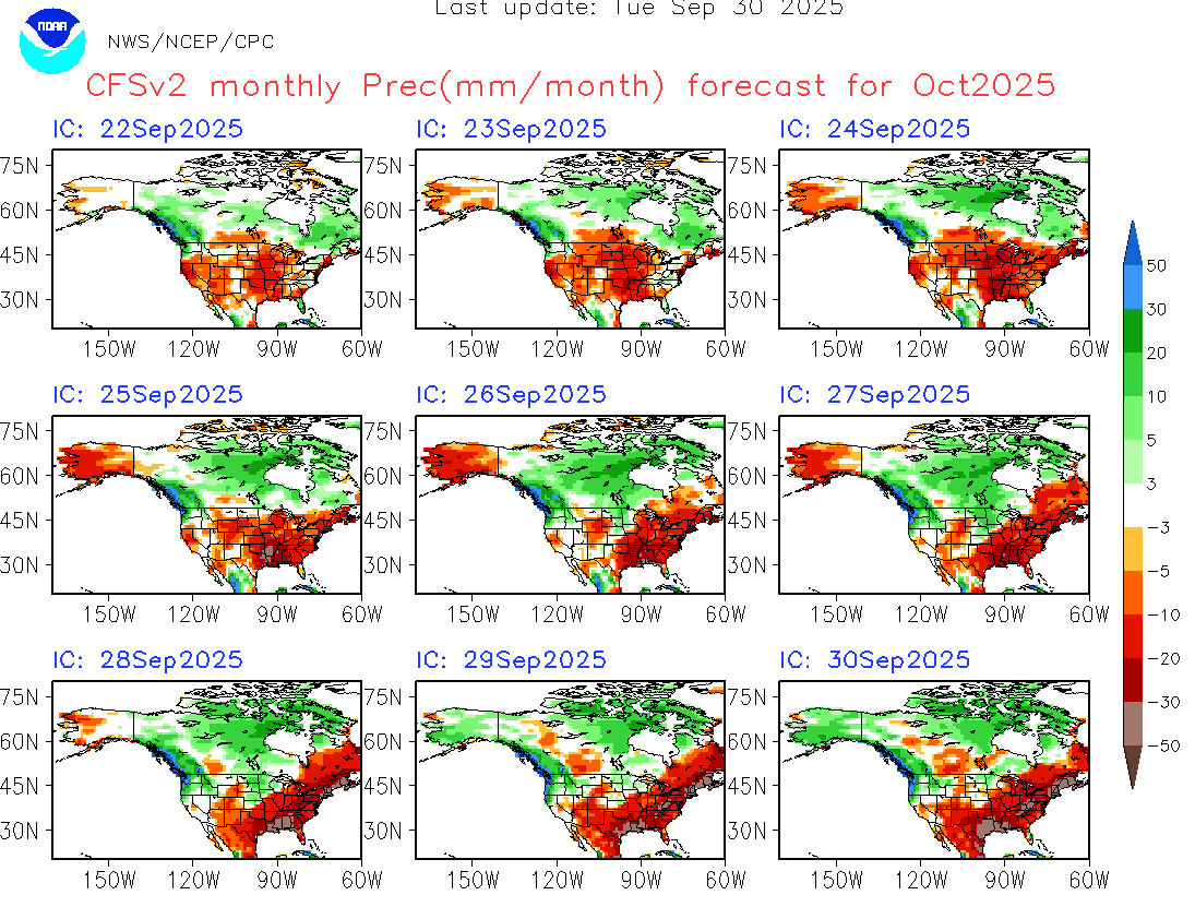
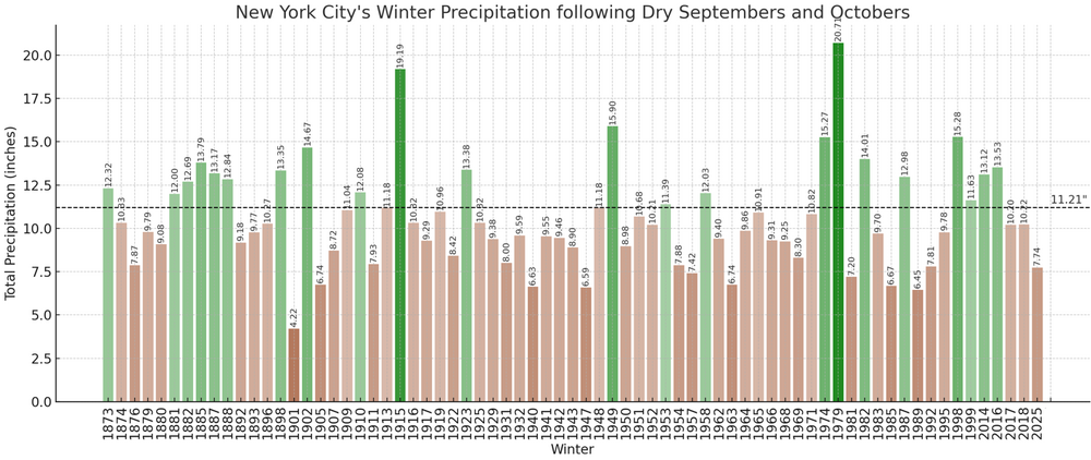
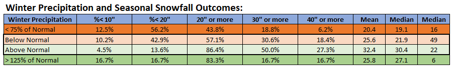
The latest runs of the CFSv2 have consistently forecast a drier to much drier than normal October. A dry October that follows a dry September has typically been followed by a drier than normal winter. At Central Park, where records go back to 1869, 69% of cases with drier than normal Septembers and Octobers were followed by drier than normal winters while 31% of such cases were followed by wetter than normal winters. Put another way, drier winters were 2.2 times as likely than wetter ones. When it comes to more extreme winters (precipitation 25% or more below normal or 25% or more above normal), 22.5% of winters were much drier than normal while 8.5% of winters were much wetter than normal. The very dry winters were 2.6 times as likely as the very wet ones. Drier winters had a tendency for less snowfall than the wetter ones. It should be noted that the coefficient of determination between winter precipitation and seasonal snowfall is very low (0.049). When winter mean temperature is added to the mix, the coefficient of determination increases to 0.288. Once the model is expanded to include Fall Precipitation, Fall Mean Temperature, Winter Precipitation, and Winter Mean Temperature, the coefficient of determination rises to 0.352. Put another way, warm and dry autumn coupled with a warm and dry winter favors below normal seasonal snowfall and explains 35% of the seasonal snowfall outcome. In short, other variables e.g., timing of systems, still have much greater influence on the overall seasonal snowfall outcome.
-
DCA _NYC _BOS _ ORD _ATL _IAH __ DEN _PHX _SEA 2.5 2.6 2.5 5.4 1.7 1.7 3.2 2.6 0.2
-
September 2025 OBS-Discussion centered NYC subforum
donsutherland1 replied to wdrag's topic in New York City Metro
Above normal temperatures will continue through tomorrow, the remainder of September. The start of October will start with arrival of the coolest air mass so far this season, but temperatures will likely quickly moderate, rising to above normal levels within a few days. The guidance and historical experience following a second half September mean temperature of 70° or above suggest that October will be warmer than normal in the New York City area. The two most recent Octobers with a cooler than normal first half like 2025 and a second half with a mean temperature of 70° or above were: 2017 (October mean temperature: 64.1° and October 2019: October mean temperature 59.9°). Imelda will approach the South Carolina coast but then turn out to sea avoiding U.S. landfall on account of Fujiwhara interaction with the stronger Humberto. The ENSO Region 1+2 anomaly was -0.1°C and the Region 3.4 anomaly was -0.5°C for the week centered around September 24. For the past six weeks, the ENSO Region 1+2 anomaly has averaged -0.12°C and the ENSO Region 3.4 anomaly has averaged -0.42°C. La Niña conditions will likely develop during mid- or late-autumn. The SOI was -16.99 today. The preliminary Arctic Oscillation (AO) was -0.298 today. Based on sensitivity analysis applied to the latest guidance, there is an implied near 100% probability that New York City will have a warmer than normal September (1991-2020 normal). September will likely finish with a mean temperature near 70.5° (1.3° above normal). Supplemental Information: The projected mean would be 2.5° above the 1981-2010 normal monthly value. -
Occasional Thoughts on Climate Change
donsutherland1 replied to donsutherland1's topic in Climate Change
The North Atlantic has a deep overturning circulation (AMOC) that pushes surface heat below resulting in a much deeper mixed layer than the North Pacific. The melting of the Greenland ice sheet has also been dumping lighter freshwater into the North Atlantic weakening the AMOC but creating a persistent area of cool SSTAs, often referred to as a 'warming hole." So, even as positive cloud feedbacks and reduction in aerosols have increased incoming solar radiation, these differences mitigate the extent of North Atlantic warming relative to the North Pacific. -
Occasional Thoughts on Climate Change
donsutherland1 replied to donsutherland1's topic in Climate Change
There's probably a complex series of interrelated factors driving the rapid warming of the North Pacific. Those factors include: Arctic sea ice-/Arctic amplification-forced changes in the circulation leading to more prolonged and deeper ridges and a shift in storm tracks Cloud-related changes/positive cloud feedbacks, e.g., reduction in low-level clouds, driven by rising atmospheric CO2 and resulting warming allowing an increase in incoming solar radiation Reduction in aerosols also allowing an increase in incoming solar radiation The North Pacific also has a shallower mixed layer, which allows for faster heating Having said this, rising anthropogenic greenhouse gas forcing is the main driver. It is increasing oceanic heat content and either driving or exacerbating the above factors. There is also some emerging literature about inter-basin teleconnections where, for example, a warming of the Gulf Stream region influences atmospheric responses, including a weakening of the Aleutian Low. -
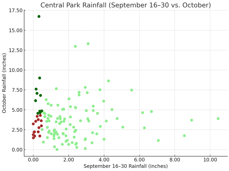
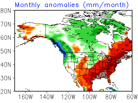
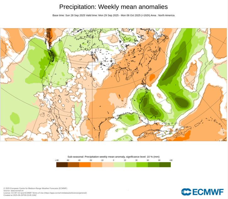
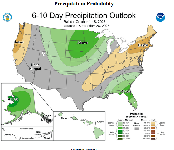
September 16-30, 2025 is on track to finish with 0.47" rainfall for Central Park. Since 1869, there have been 25 cases with 0.50" or less rainfall during the second half of September. Among those cases, 60% went on to have a drier than normal October while 40% went on to have a wetter than normal October. The latest CFSv2 monthly forecast shows a drier to much drier than normal October: The latest ECMWF weeklies also show a drier than normal start to October: CPC's 6-10-day precipitation forecast also favors drier than normal conditions: However, its monthly forecast from September 18th indicates equal chances of above or below normal precipitation. Finally, of the 8 years with mean temperatures of 70° or above during the second half of September coupled with < 1.00" rainfall, 75% were followed by a drier than normal October. The two exceptions were 2005 and 2019. All said, the odds lean toward a drier than normal October, but that isn't cast in stone.
-
September 2025 OBS-Discussion centered NYC subforum
donsutherland1 replied to wdrag's topic in New York City Metro
79 at JFK. -
Occasional Thoughts on Climate Change
donsutherland1 replied to donsutherland1's topic in Climate Change
I agree about the corrupting influence of oligarchs. However, the public matters, as the public votes. -
September 2025 OBS-Discussion centered NYC subforum
donsutherland1 replied to wdrag's topic in New York City Metro
Under bright sunshine and deep blue skies, parts of the region saw near record and record warm temperatures. High temperatures included: Hartford: 85° Islip: 84° (old record: 80°, 2015) New York City-Central Park: 83° New York City-LaGuardia Airport: 85° (old record: 84°, 2014) Newark: 89° (old record: 87°, 2014) White Plains: 85° (old record: 84°, 2014) Tomorrow and Tuesday will be a bit cooler on account of increased cloud cover. Nevertheless, above normal temperatures will continue through the remainder of September. The start of October could see the arrival of the coolest air mass so far this season, but temperatures will likely quickly moderate, rising to above normal levels. The guidance and historical experience following a second half September mean temperature of 70° or above suggest that October will be warmer than normal in the New York City area. The two most recent Octobers with a cooler than normal first half like 2025 and a second half with a mean temperature of 70° or above were: 2017 (October mean temperature: 64.1° and October 2019: October mean temperature 59.9°). Imelda will approach the South Carolina coast but then turn out to sea avoiding U.S. landfall on account of Fujiwhara interaction with the stronger Humberto. Even without landfall, Imelda will bring some periods of heavy rain, gusty winds, and pounding surf to coastal areas. The ENSO Region 1+2 anomaly was 0.0°C and the Region 3.4 anomaly was -0.4°C for the week centered around September 17. For the past six weeks, the ENSO Region 1+2 anomaly has averaged -0.03°C and the ENSO Region 3.4 anomaly has averaged -0.38°C. La Niña conditions will likely develop during mid- or late-autumn. The SOI was -14.62 today. The preliminary Arctic Oscillation (AO) was -0.108 today. Based on sensitivity analysis applied to the latest guidance, there is an implied near 100% probability that New York City will have a warmer than normal September (1991-2020 normal). September will likely finish with a mean temperature near 70.4° (1.2° above normal). Supplemental Information: The projected mean would be 2.4° above the 1981-2010 normal monthly value. -
September 2025 OBS-Discussion centered NYC subforum
donsutherland1 replied to wdrag's topic in New York City Metro
Newark has now reached 86°. The last time Newark had at least five days with highs of 86° or above during the second half of September was 2019. In addition, Islip has reached 82°. That breaks the daily record of 80° from 2015. Newark has reached 88°, which breaks the daily mark of 87° from 2014. -
September 2025 OBS-Discussion centered NYC subforum
donsutherland1 replied to wdrag's topic in New York City Metro
Islip has now reached 80° for the sixth time during the second half of September. That ties 1970 for the fourth highest total. The three consecutive days is the first such streak after September 15th since October 6-8, 2007. -
September 2025 OBS-Discussion centered NYC subforum
donsutherland1 replied to wdrag's topic in New York City Metro
I didn't use dense ranking. But yes, it would be tied for 16th most using dense ranking. -
Occasional Thoughts on Climate Change
donsutherland1 replied to donsutherland1's topic in Climate Change
This is why I periodically call attention to social media influencers and celebrities (i.e., Bastardi, Wielicki, Martz, etc) on X and elsewhere. They push themselves as climate experts when they have little or no knowledge of climate/climate change while frequently attacking scientists who have devoted their lives and careers to cutting-edge research. These influencers/celebrities see things only in terms of cherry-picked ideas in their own fields constrained by their own ideology and personal preferences, to distort the science and undermine public understanding. Moreover, they prey on public ignorance to build their status. -
September 2025 OBS-Discussion centered NYC subforum
donsutherland1 replied to wdrag's topic in New York City Metro
No. The ice wasn't sufficiently thick. -
September 2025 OBS-Discussion centered NYC subforum
donsutherland1 replied to wdrag's topic in New York City Metro
Newark has reached 80F (26.7C) for the 100th time this year. That is tied with 2017 and 2019 for the 21st highest number of days. 50% of Newark's years with 100 or more such days have occurred since 2000. -
September 2025 OBS-Discussion centered NYC subforum
donsutherland1 replied to wdrag's topic in New York City Metro
The Long Island Sound froze during winter 2014-15. That hasn’t happened since then. -
September 2025 OBS-Discussion centered NYC subforum
donsutherland1 replied to wdrag's topic in New York City Metro
December 2015: 3.71 sigma above the 1991-2020 mean February 2015: 2.71 sigma below the 1991-2020 mean December 1989: 2.78 sigma below the 1971-2000 mean (3.30 sigma below the 1991–2020 mean). For the full climate record: +3.41 sigma, -2.07 sigma, and -2.41 sigma respectively. -
September 2025 OBS-Discussion centered NYC subforum
donsutherland1 replied to wdrag's topic in New York City Metro
It's not easy. A month like December 2015 is a rarity. Let's have a look at the difficulty involved. The warmer models show a mean high of 73.0° for October 1-10. That means that October 11-31 would need a mean high of 76.0° to bring the average monthly high to 75.0°. The warmest October 11-31 period is 1947 with a mean high of 73.4°. The latest-season 21-day period with a mean temperature of 76.0° or above was September 28-October 18, 1954 with a mean high of 76.0°. So, to get the 75.0° mean monthly high, something extraordinary would have to occur given current guidance, climatology, and historic extremes. One would probably need an extended bout of record and near-record high temperatures somewhere in the 21-day period, assuming that the guidance for October 1-10 is reasonably accurate.