donsutherland1
-
Posts
23,988 -
Joined
Content Type
Profiles
Blogs
Forums
American Weather
Media Demo
Store
Gallery
Everything posted by donsutherland1
-
September 2025 OBS-Discussion centered NYC subforum
donsutherland1 replied to wdrag's topic in New York City Metro
Today was an unseasonably warm late September day. Preliminary highs included: Bridgeport: 84° Islip: 85° (tied record from 1983) New Haven: 84° New York Cty-Central Park: 84° New York City-JFK Airport: 86° New York City-LaGuardia Airport: 83° Newark: 86° Philadelphia: 84° Westhampton: 83° (tied record set in 1967 and tied in 2024) White Plains: 83° Cooler air will return overnight for the weekend. Temperatures will top out mainly in the lower 70s tomorrow through Monday. It will then turn warmer on Tuesday before another cool front crosses the region on Wednesday. The advancing front could trigger some showers or thundershowers. The ENSO Region 1+2 anomaly was -0.2°C and the Region 3.4 anomaly was -0.5°C for the week centered around September 10. For the past six weeks, the ENSO Region 1+2 anomaly has averaged +0.10°C and the ENSO Region 3.4 anomaly has averaged -0.37°C. La Niña conditions will likely develop during mid- or late-autumn. The SOI was -4.34 today. The preliminary Arctic Oscillation (AO) was -0.972 today. Based on sensitivity analysis applied to the latest guidance, there is an implied near 57% probability that New York City will have a cooler than normal September (1991-2020 normal). September will likely finish with a mean temperature near 69.0° (0.2° below normal). Supplemental Information: The projected mean would be 1.0° above the 1981-2010 normal monthly value. -
September 2025 OBS-Discussion centered NYC subforum
donsutherland1 replied to wdrag's topic in New York City Metro
86 (record was 90 in 1983). -
September 2025 OBS-Discussion centered NYC subforum
donsutherland1 replied to wdrag's topic in New York City Metro
Westhampton has reached 83°. That ties the daily record for September 19th that was set in 1967 and tied in 1983. Records go back to 1951. -
September 2025 OBS-Discussion centered NYC subforum
donsutherland1 replied to wdrag's topic in New York City Metro
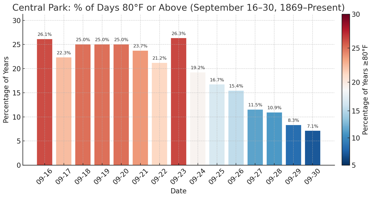
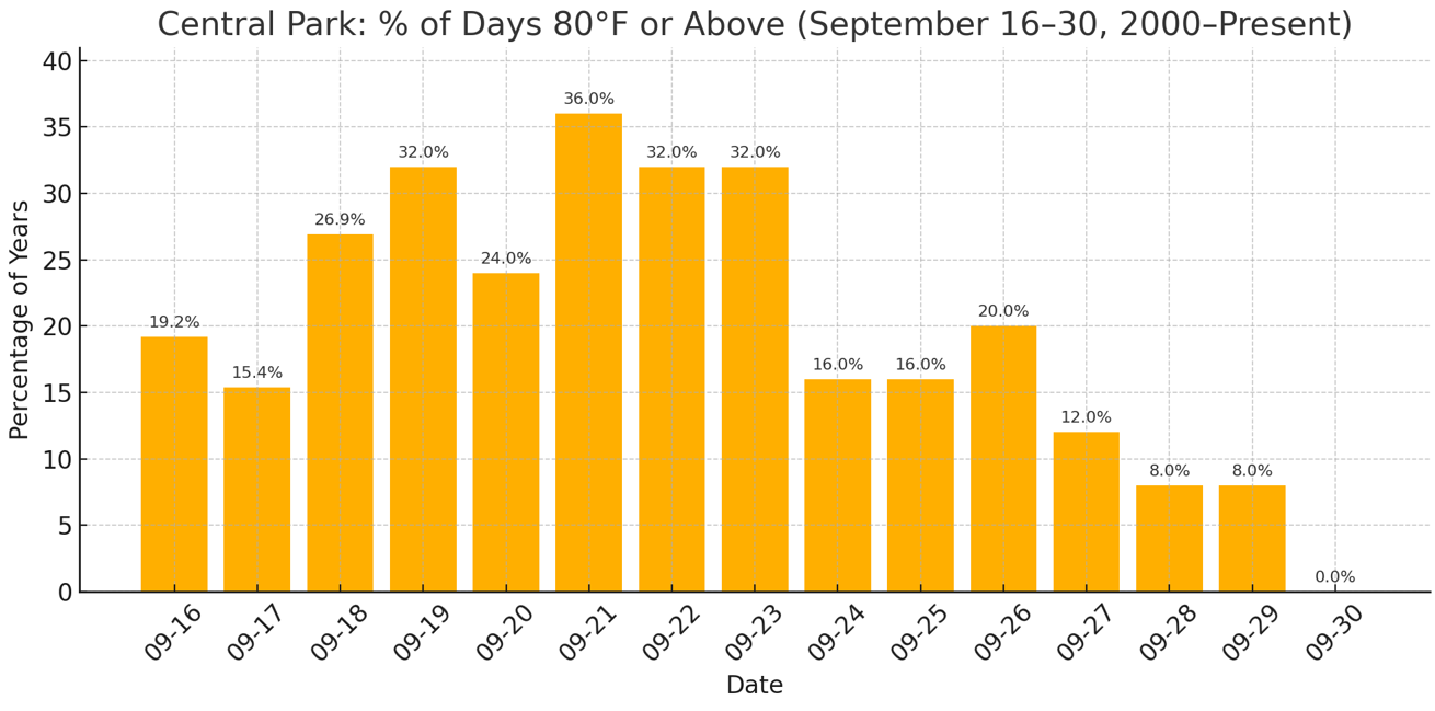
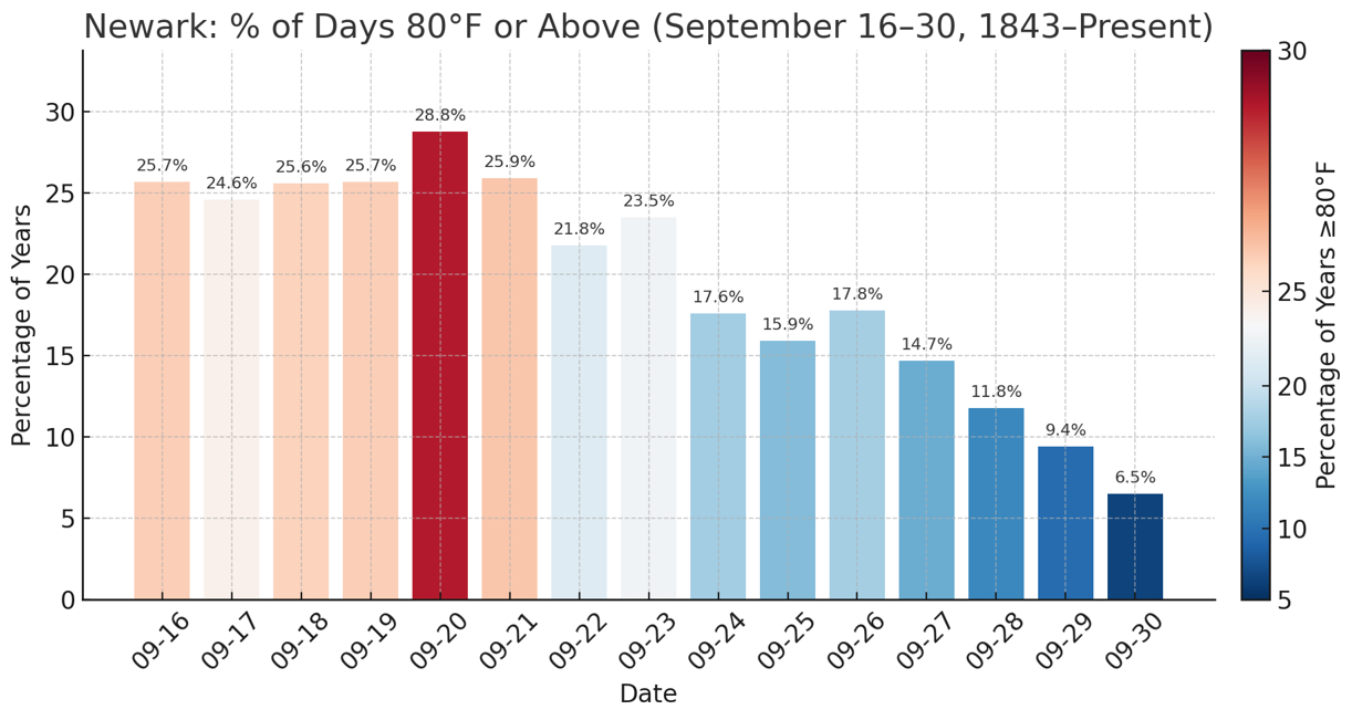
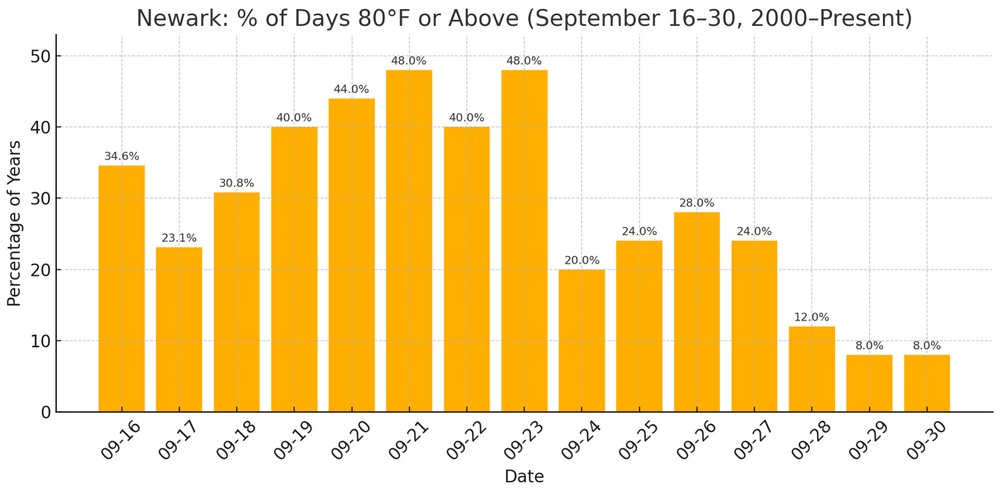
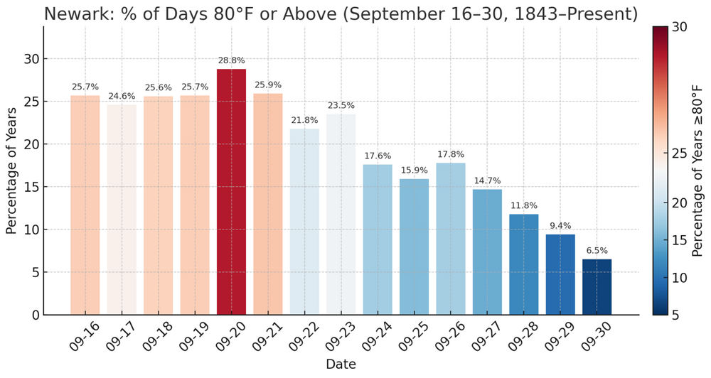
At Central Park, the temperature has reached 83° so far after yesterday's 83°. Through September 23, New York City has seen at least one-in-five years reach 80° or above on each date in the second half of September. The frequency of such warmth decreases afterward. Even during the shorter 2000-present timeframe, there has been a drop in the frequency of such warmth after September 23: At Newark, the temperature has reached 86° so far after yesterday's 87°. Newark takes a step down in the frequency of 80° or above warmth after September 23 and again after September 26. Since 2000, the frequency of such warmth has increased on all but September 17 (likely to have more to do with sample size issues rather than a genuine cooling). Note: All charts include September 16-18, 2025 data.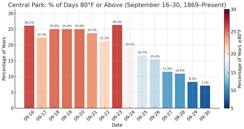

-
September 2025 OBS-Discussion centered NYC subforum
donsutherland1 replied to wdrag's topic in New York City Metro
Tomorrow will be partly cloudy and unseasonably warm. Temperatures will top out in the lower 80s. The warmer spots could see some middle and perhaps upper 80s. Cooler air will return for the weekend with another warmup possible starting early next week. The ENSO Region 1+2 anomaly was -0.2°C and the Region 3.4 anomaly was -0.5°C for the week centered around September 10. For the past six weeks, the ENSO Region 1+2 anomaly has averaged +0.10°C and the ENSO Region 3.4 anomaly has averaged -0.37°C. La Niña conditions will likely develop during mid- or late-autumn. The SOI was +4.40 today. The preliminary Arctic Oscillation (AO) was -0.972 today. Based on sensitivity analysis applied to the latest guidance, there is an implied near 54% probability that New York City will have a warmer than normal September (1991-2020 normal). September will likely finish with a mean temperature near 69.3° (0.1° above normal). Supplemental Information: The projected mean would be 1.3° above the 1981-2010 normal monthly value. -
September 2025 OBS-Discussion centered NYC subforum
donsutherland1 replied to wdrag's topic in New York City Metro
I meant for this to be in the banter thread, but the point is that one has to use established definitions consistently for clear communication. Otherwise, confusion can erode preparedness and public safety. -
September 2025 OBS-Discussion centered NYC subforum
donsutherland1 replied to wdrag's topic in New York City Metro
Perhaps because his tropical forecast is in bad shape due to a quiet hurricane season so far, Joe Bastardi is now insisting that meteorologists embrace his private fiction of what constitutes a tropical cyclone. As noted previously, the system had fronts. It was a nor'easter. It was not a tropical cyclone. It should not have been classified as a tropical cyclone any more than a winter nor'easter should be classified as a tropical storm or hurricane.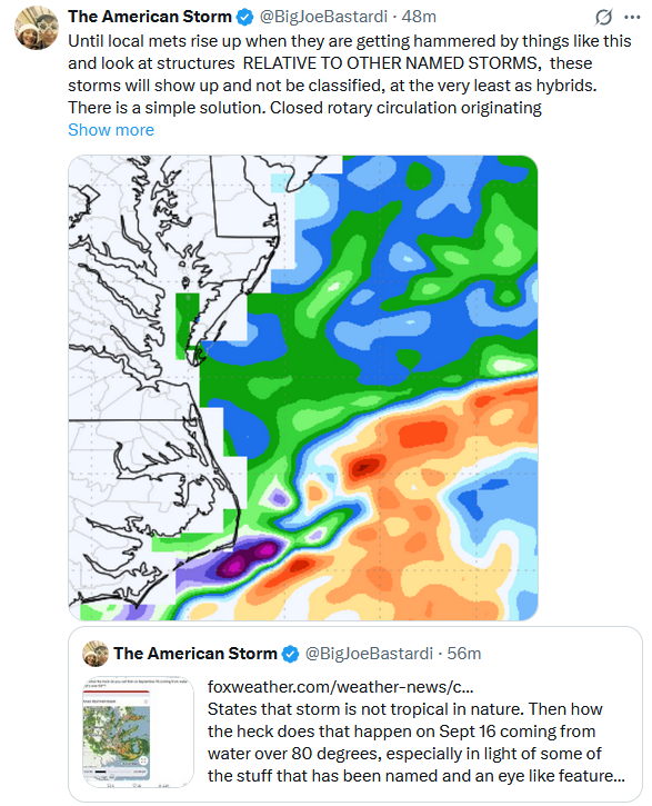
-
September 2025 OBS-Discussion centered NYC subforum
donsutherland1 replied to wdrag's topic in New York City Metro
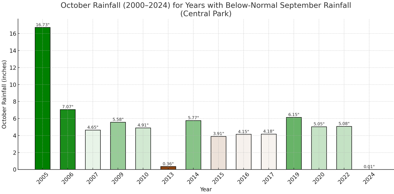
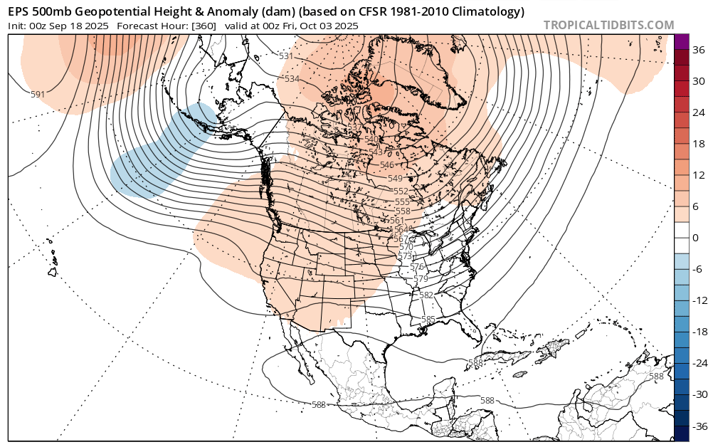
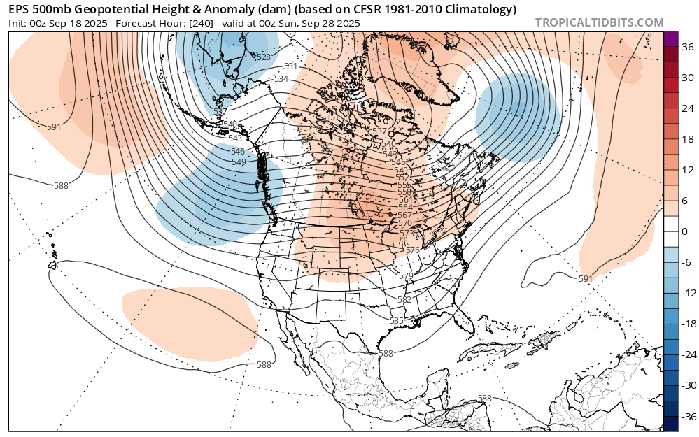
The overall dry September is consistent with the exceptionally dry end to August that had occurred. Indeed, the monthly CFSv2 initially called for a wet September before finally reverting to a dry September. Despite early rainfall during the month, highlighted by an unusually wet week following such a dry end to August, monthly rainfall is now below normal in New York City. Central Park: September 1-18: 2.30" 1991-2020 Average: 2.52" The guidance shows little or no rainfall for at least the next seven days. Statistically, the odds would somewhat favor a rebound in rainfall during October. Since 2000, 64% of drier than normal Septembers were followed by somewhat wetter to wetter than normal Octobers. However, with quasi-resonant amplification driven by changes in the Arctic producing "stuck patterns" that lead to longer-duration patterns, a dry October is possible. Indeed, during the last 10 years, dry Septembers were somewhat more likely (56%) to be followed by a drier than normal October. The most recent such case was October 2024. At present, the CFSv2 is showing drier than normal conditions in the Northeast. The ECMWF weeklies also begin October with near normal to possibly drier than normal conditions. October 2005 saw greatly elevated rainfall due to tropical moisture. Moisture from Subtropical Depression 22 dumped 4.49" of rain during October 7-8. Another system moving along a stalled frontal boundary brought 8.64" of rain during October 11-14. Nassau and Suffolk County saw the heaviest amounts with Lynbrook picking up 14.82", Riverhead receiving 14.26", and Wading River seeing 14.52". Moisture from Extratropical Wilma enhanced rainfall from a developing system along a frontal boundary that saw 2.36" rain fall during October 24-26. The emerging 500 mb pattern could provide insight as one draws closer to October. Very dry Octobers (<1.00" monthly rainfall) 1990-2024: Very wet Octobers (7.00" or more) 1990-2024: The September 18, 2025 0z EPS at 240 hours and 360 hours leans toward a dry start: 240 Hours: 360 Hours: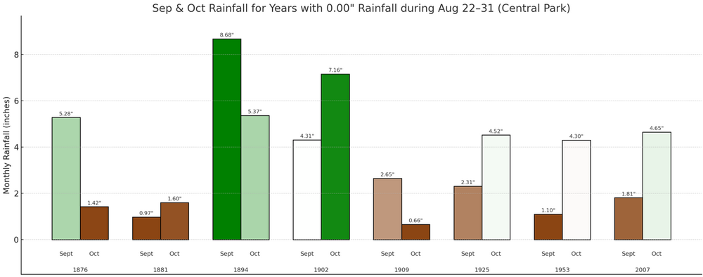


-
September 2025 OBS-Discussion centered NYC subforum
donsutherland1 replied to wdrag's topic in New York City Metro
The system responsible for today's showers and periods of rain will slowly move away from the region tonight and tomorrow. As a result, clouds will break tomorrow morning and a partly to mostly sunny afternoon will follow. Temperatures will return to the upper 70s tomorrow and then rise further into the lower 80s on Friday. The warmer spots could see some middle 80s on Friday. Cooler air will return for the weekend with another warmup possible starting early next week. The ENSO Region 1+2 anomaly was -0.2°C and the Region 3.4 anomaly was -0.5°C for the week centered around September 10. For the past six weeks, the ENSO Region 1+2 anomaly has averaged +0.10°C and the ENSO Region 3.4 anomaly has averaged -0.37°C. La Niña conditions will likely develop during mid- or late-autumn. The SOI was +4.93 today. The preliminary Arctic Oscillation (AO) was -1.179 today. Based on sensitivity analysis applied to the latest guidance, there is an implied near 51% probability that New York City will have a cooler than normal September (1991-2020 normal). September will likely finish with a mean temperature near 69.1° (0.1° below normal). Supplemental Information: The projected mean would be 1.1° above the 1981-2010 normal monthly value. -
September 2025 OBS-Discussion centered NYC subforum
donsutherland1 replied to wdrag's topic in New York City Metro
For New York City, the connection isn't as strong. Since 2000, a wet fall is more likely to be followed by a wet winter. Dry falls were only slightly more likely to be followed by wet winters (using the 1991-2020 baselines) for New York City (Central Park). Drier than Normal Falls: 54.5% were followed by above-normal winter precipitation (Last: Fall 2024/Winter 2024-2025) 45.5% were followed by below-normal winter precipitation (Last: Fall 2017/Winter 2017-2018) Wetter than Normal Falls: 61.5% were followed by above-normal winter precipitation (Last: Fall 2023/Winter 2023-2024) 38.5% were followed by below-normal winter precipitation (Last: Fall 2022/Winter 2022-2023) -
September 2025 OBS-Discussion centered NYC subforum
donsutherland1 replied to wdrag's topic in New York City Metro
Picard, My data comes mainly from: https://xmacis.rcc-acis.org/ I periodically use teleconnections data: https://ftp.cpc.ncep.noaa.gov/cwlinks/ and Climate Data: https://www.ncei.noaa.gov/access/monitoring/climate-at-a-glance/ Most of this data can readily be downloaded or converted into .CSV and .XLSX files -
2025-2026 ENSO
donsutherland1 replied to 40/70 Benchmark's topic in Weather Forecasting and Discussion
He's done invaluable work. I share your sentiments. -
2025-2026 ENSO
donsutherland1 replied to 40/70 Benchmark's topic in Weather Forecasting and Discussion
If one is looking for an idea of the warmest potential for any winter (month, season, or year) in the current climate regime (defined as the most recent 30 periods e.g. winters), one can come up with confidence intervals from a linear regression equation. A 1-in-1,000 year probability for the current regime would be the 99.9% confidence interval. For NYC, that value for a winter mean temperature is currently 44.8° (record is 41.6°, in 2001-02). The coefficient of determination for NYC is 0.545. Recently, though, some cities have seen months or even seasons breach this threshold e.g., July 2023 in Phoenix. -
2025-2026 ENSO
donsutherland1 replied to 40/70 Benchmark's topic in Weather Forecasting and Discussion
It seems quite bizarre, especially with the embedded simulated radar image from a snowstorm that almost certainly won't be equaled during any of our lifetimes in the Deep South. -
September 2025 OBS-Discussion centered NYC subforum
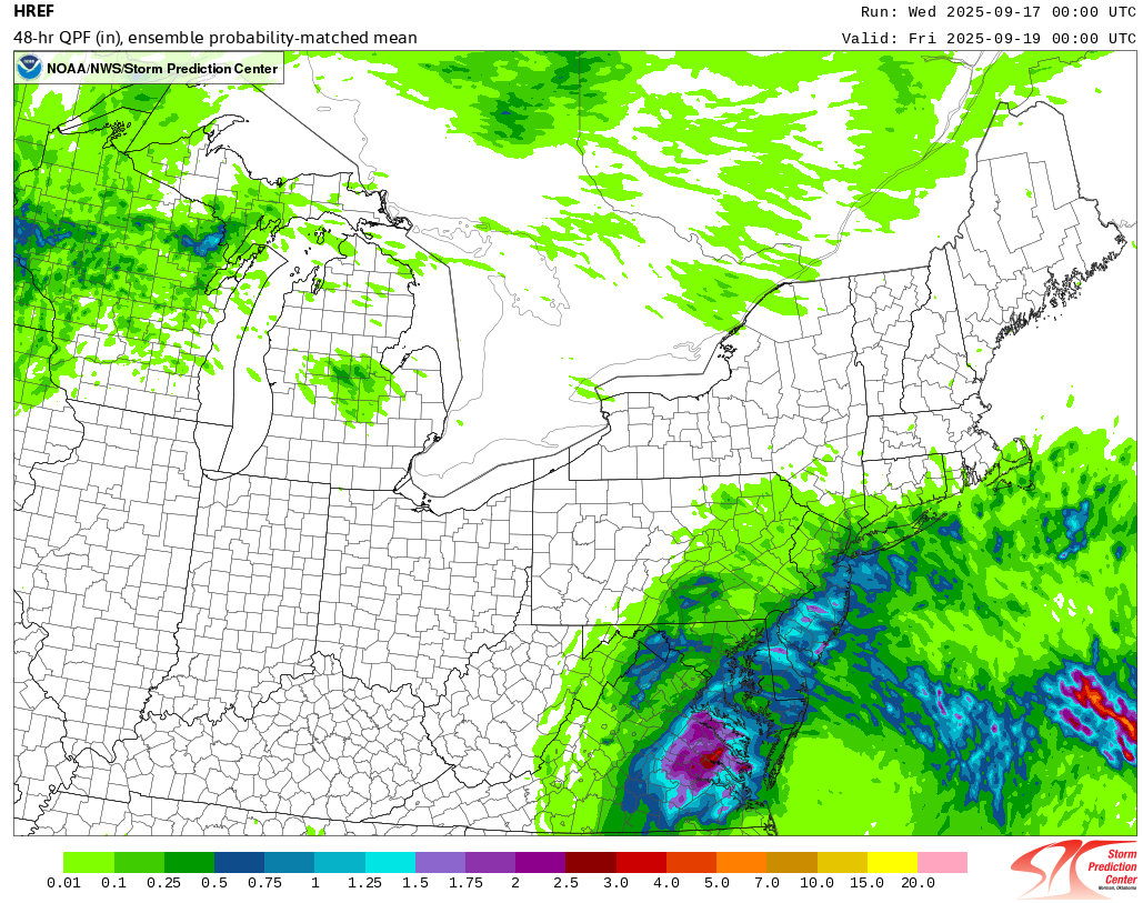
donsutherland1 replied to wdrag's topic in New York City Metro
Latest HREF: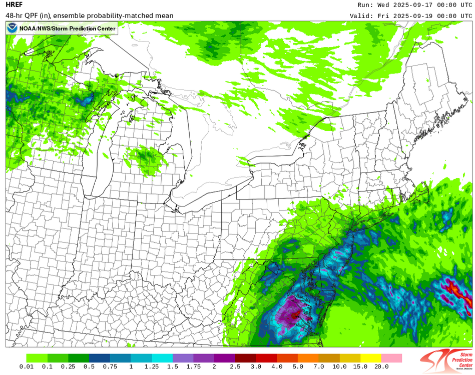
-
Winter cancelled/uncancelled banter 25/26
donsutherland1 replied to Rjay's topic in New York City Metro
Joe Bastardi is arguing that the current nor'easter that has dumped more than 3" of rain at Norfolk over the past two days with gusts of 50 mph should be counted as a tropical cyclone: The flaw in his reasoning is that the system has fronts. Thus, it is not a tropical cyclone.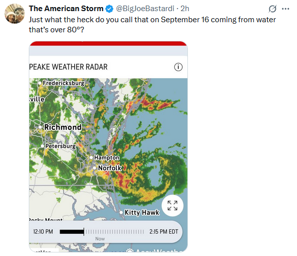
-
September 2025 OBS-Discussion centered NYC subforum
donsutherland1 replied to wdrag's topic in New York City Metro
A strong nor'easter was bringing gusty winds and heavy rain to parts of the Middle Atlantic region late this afternoon. Through 4 pm, Norfolk had picked up 2.14" of rain. The wind has gusted to 44 mph there. This storm will bring some showers and periods of rain tomorrow into Thursday. The Delmarva and Jersey Shore will see the heaviest amounts. There, 1.00" or above amounts are likely. The temperature will top out in the upper 60s to lower 70s tomorrow. Readings will likely return to the upper 70s on Thursday and the lower 80s on Friday. Cooler air will return for the weekend. The ENSO Region 1+2 anomaly was -0.2°C and the Region 3.4 anomaly was -0.5°C for the week centered around September 10. For the past six weeks, the ENSO Region 1+2 anomaly has averaged +0.10°C and the ENSO Region 3.4 anomaly has averaged -0.37°C. La Niña conditions will likely develop during mid- or late-autumn. The SOI was -2.20 yesterday. The preliminary Arctic Oscillation (AO) was -1.002 today. Based on sensitivity analysis applied to the latest guidance, there is an implied near 56% probability that New York City will have a cooler than normal September (1991-2020 normal). September will likely finish with a mean temperature near 68.9° (0.3° below normal). Supplemental Information: The projected mean would be 0.9° above the 1981-2010 normal monthly value. -
September 2025 OBS-Discussion centered NYC subforum
donsutherland1 replied to wdrag's topic in New York City Metro
So far, rainfall is running above the guidance in a number of locations through 18z.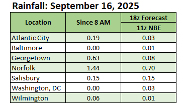
-
September 2025 OBS-Discussion centered NYC subforum
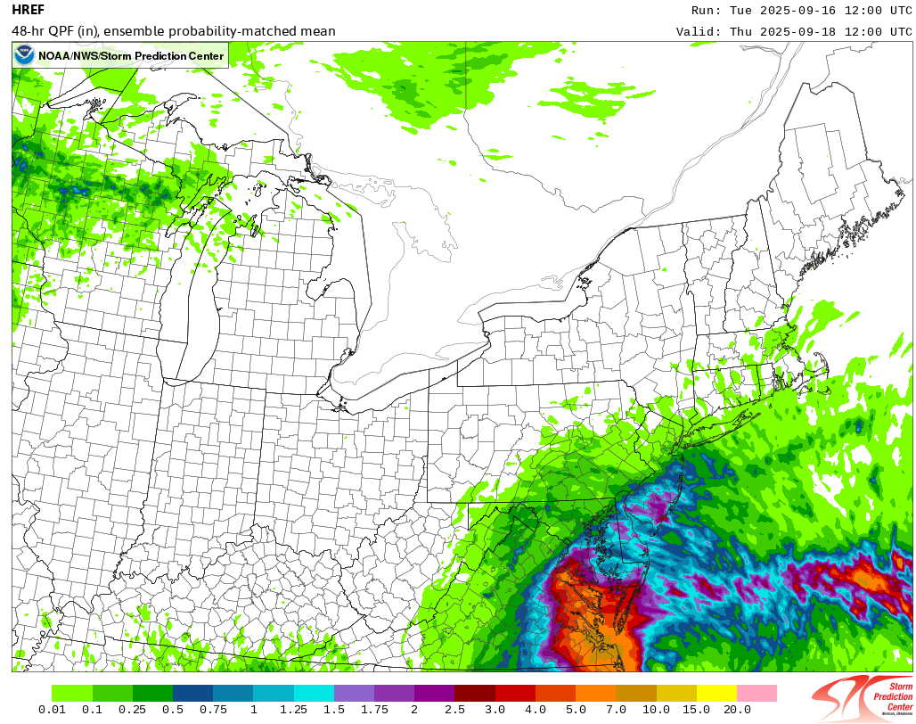
donsutherland1 replied to wdrag's topic in New York City Metro
The 9/16 12z HREF: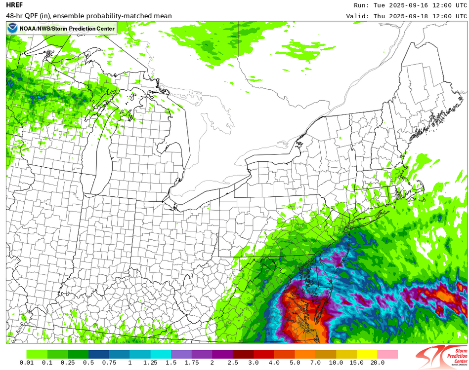
-
2025-2026 ENSO
donsutherland1 replied to 40/70 Benchmark's topic in Weather Forecasting and Discussion
I agree. I don't think it's non-viable. I just don't think it's the slam dunk some are making it out to be. -
September 2025 OBS-Discussion centered NYC subforum
donsutherland1 replied to wdrag's topic in New York City Metro
Belmar and perhaps Staten Island could see an inch. I think amounts will be less on Long Island, though. -
2025-2026 ENSO
donsutherland1 replied to 40/70 Benchmark's topic in Weather Forecasting and Discussion
I haven't looked closely at all the details at this time given how much can change. It is a better North Pacific match than 2013-14, at least right now. It wasn't a bad winter, either. -
September 2025 OBS-Discussion centered NYC subforum
donsutherland1 replied to wdrag's topic in New York City Metro
Coastal low is a broad term for the system. Nor'easters are coastal lows. -
2025-2026 ENSO
donsutherland1 replied to 40/70 Benchmark's topic in Weather Forecasting and Discussion
I'm not expecting perfection. But I think boundary conditions, particularly SSTAs are probably the most important variables. The area of warmest Winter 2013-14 North Pacific SSTAs are not a great match with what currently exists. At present, Winter 2020-21 is a better North Pacific Match (again not perfect, but better).
-
2025-2026 ENSO
donsutherland1 replied to 40/70 Benchmark's topic in Weather Forecasting and Discussion
It seems that 2013-14 is a popular analog on social media right now. That the North Pacific SSTs are not similar to those of 2013-14 doesn't phase those speculating. Right now, if the anomalies stay as is, one would be dealing with a weaker Aleutian Low, which teleconnects to milder conditions in the East. Should dual areas of excessive warmth persist, there could be some variability, but again not the kind of consistent cold seen during winter 2013-14. We'll see how things evolve in coming months.