donsutherland1
-
Posts
23,988 -
Joined
Content Type
Profiles
Blogs
Forums
American Weather
Media Demo
Store
Gallery
Everything posted by donsutherland1
-
2025-2026 ENSO
donsutherland1 replied to 40/70 Benchmark's topic in Weather Forecasting and Discussion
What this means is that the social media hurricane hypesters will simply shift the goalposts to a few weeks down the road to maybe late September or October (an art that many have perfected from punting long-range cold/snow calls when they don't verify). I suspect that there will be some activity before the season concludes, so they will also proclaim that they were correct. Also, there's no reason the current season can't end with only a modest uptick in activity. Every season does not end with a spectacular burst of late-season storms. There's a window currently suggested on the MJO guidance for the second half of September (probably after the 20th) into the first week of October. Afterward, things could largely shut down. The forecast lift isn't as great or widespread as one would look for if there were to be a big explosion of tropical cyclone genesis or a large number of hurricanes.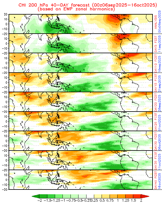
-
September 2025 OBS-Discussion centered NYC subforum
donsutherland1 replied to wdrag's topic in New York City Metro
Today saw the temperature top out at 90° at Newark and strong thunderstorms bring drenching rainfall to parts of the region. Newark reached 90° or above in June, July, August, and September for the first time since 2023. 2023 also saw the mercury hit 90° in May, unlike this year. Hourly rainfall amounts included: Central Park: 0.89", LaGuardia Airport: 0.78"; and, White Plains: 0.90". Today is Central Park's wettest day since 2.64" fell on July 14. A cold front crossing the region will bring additional showers and thundershowers tonight. Rain could linger into tomorrow as the front slows. A general 0.50"-1.50" rainfall is likely around the New York City area and its nearby suburbs with localized amounts in excess of 2.00" by the time the rain ends tomorrow. Following the passage of the cold front, highs will reach the upper 60s to lower 70s tomorrow. Afterward, temperatures will mainly top out in the 70s during the daytime and fall into the 50s at nighttime in New York City through at least the middle of next week. Additional showers or rain is possible around midweek. The ENSO Region 1+2 anomaly was -0.3°C and the Region 3.4 anomaly was -0.4°C for the week centered around August 27. For the past six weeks, the ENSO Region 1+2 anomaly has averaged +0.33°C and the ENSO Region 3.4 anomaly has averaged -0.32°C. La Niña conditions will likely develop during mid- or late-autumn. The SOI was +17.47 today. The preliminary Arctic Oscillation (AO) was -0.837 today. -
September 2025 OBS-Discussion centered NYC subforum
donsutherland1 replied to wdrag's topic in New York City Metro
0.78" hourly amount at Central Park as of 3:32 pm. -
September 2025 OBS-Discussion centered NYC subforum
donsutherland1 replied to wdrag's topic in New York City Metro
For reference: Highest hourly amount for September 6: 0.96", 2008. -
September 2025 OBS-Discussion centered NYC subforum
donsutherland1 replied to wdrag's topic in New York City Metro
Newark has reached 90° for the 39th time this year. Thunder is also reported. -
2025-2026 ENSO
donsutherland1 replied to 40/70 Benchmark's topic in Weather Forecasting and Discussion
I suspect that its seeming inability to see cold anomalies except at shorter timescales has a lot to do with the idea that boundary conditions drive seasonal averages. ENSO, PDO are prominent conditions. The oceans overall are warming. Therefore, the model forecasts are tipped toward the warmer idea more broadly than is realistic. Worse, the coefficients of determination for such variables related to boundary conditions and actual seasonal outcomes are very low. These weak relationships reveal that other important factors are involved, including synoptic scale events that cannot be reliably forecast beyond 10-14 days. Some of these additional variables may not yet be known. Synoptic scale events i.e., large snowstorms, Arctic blasts, etc., can have a great influence on the overall seasonal outcomes. Thus, even a warm winter can be much snowier than normal or a cold winter can lack snowfall. On account of these other variables, every La Niña or El Niño event is not alike. The seasonal models are not yet at a stage where they can even begin to consistently resolve the actual events that ultimately produce the seasonal outcome. A similar situation applies to subseasonal forecasting. Not surprisingly, beyond two weeks, model skill on the weekly guidance largely disappears. There also seems to be a larger deal of persistence in the two week or longer forecasts than what actually occurs. AI may improve some of these outcomes. But even then, big challenges could still persist. For example, even as some experiments with random forest models have shown a degree of improved skill in forecasting ENSO, those models are constrained by their knowledge base. Hence, when it comes to forecasting extreme events e.g., super El Niño events, they have great difficulty. Perhaps the combination of AI and quantum computing might produce some significant breakthroughs. But that's still in the future and perhaps a decade or more away, assuming society values science and basic research to make the investments necessary to arrive at that improved state of forecasting. That's an open question in some areas and it will become even more relevant as major states grapple with the costs of aging populations, rising debt relative to GDP, etc., and the trade-offs involved in making budget allocations. -
Winter cancelled/uncancelled banter 25/26
donsutherland1 replied to Rjay's topic in New York City Metro
With ECMWF seasonal maps coming out, focus briefly turns to the coming winter. While it is far too soon to expect much skill from the models, recent winter outcomes suggest that New York City is beginning to put distance between the present and a golden snowfall era. The core of winter (December-February) was especially snowy for the most part from Winter 1999-00 through Winter 2017-18. Storms dumped an average of 2.9" per event and there were 30 days with 6" or more snow, including 9 with 10" or more. The December-February periods saw an average of 28.2" of snow. For all other winters, storms averaged 1.9" per event with the December-February period averaging 20.8".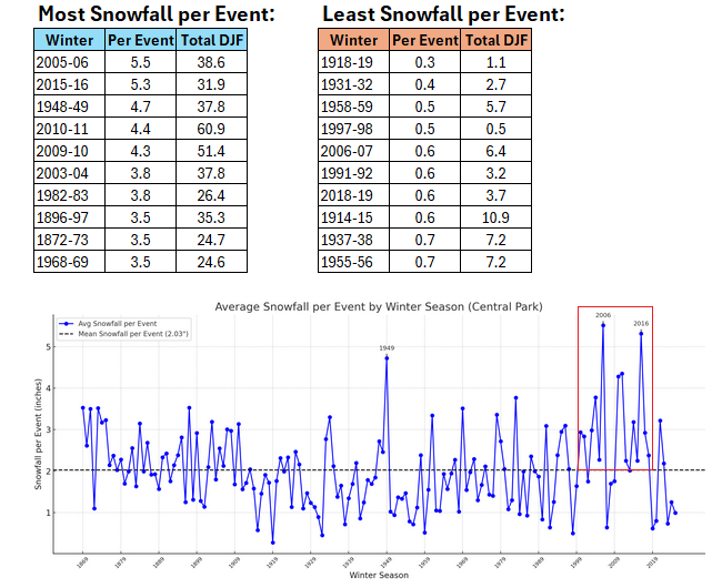
-
September 2025 OBS-Discussion centered NYC subforum
donsutherland1 replied to wdrag's topic in New York City Metro
The 0.48" rainfall at Bridgeport today broke the daily record for September 5. The old mark of 0.44" was set in 2012. -
2025-2026 ENSO
donsutherland1 replied to 40/70 Benchmark's topic in Weather Forecasting and Discussion
Here you go:
-
2025-2026 ENSO
donsutherland1 replied to 40/70 Benchmark's topic in Weather Forecasting and Discussion
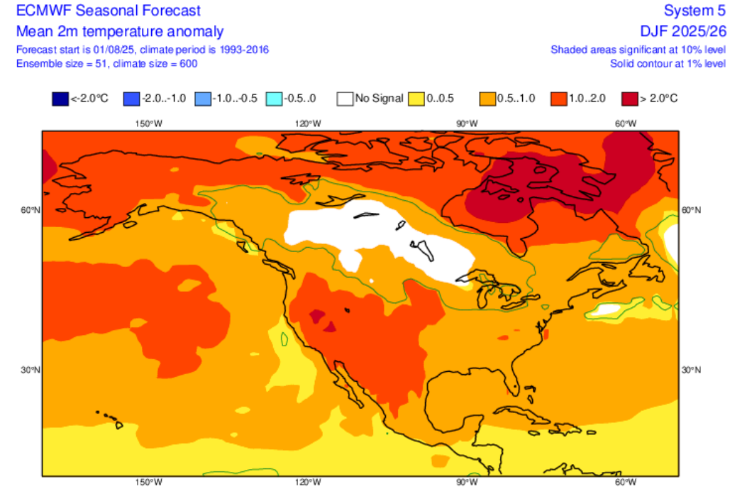
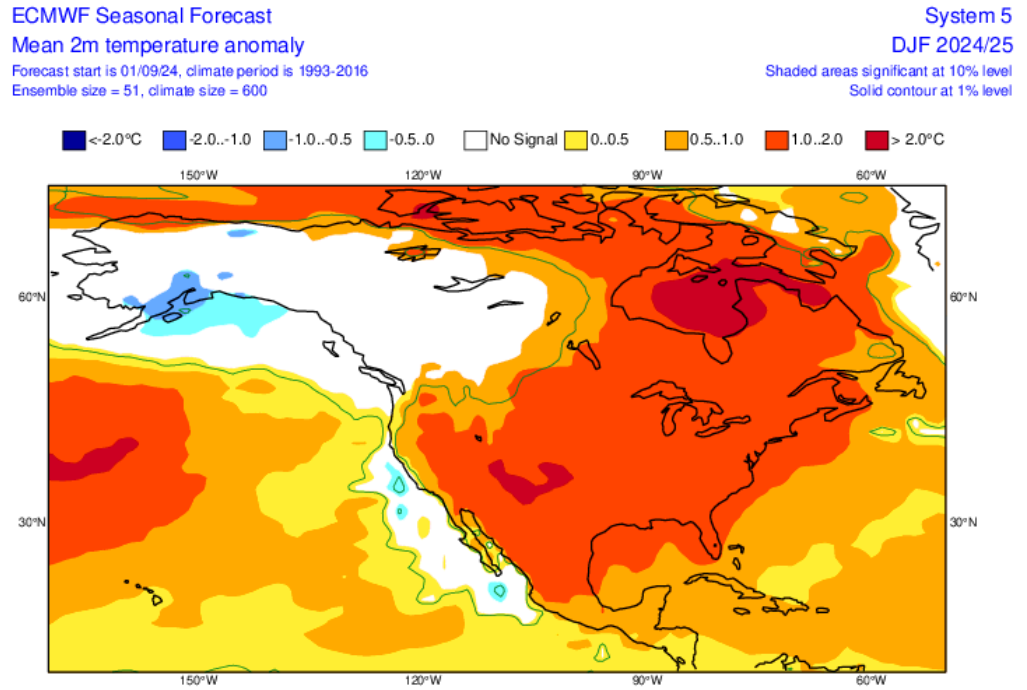
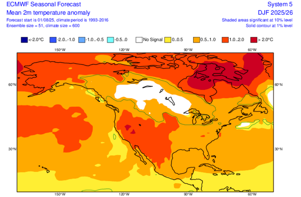
It was. Notice how similar the map looks to last September's outlook for the past winter. I suspect that the similarity reveals that the expected ENSO state plays a disproportionate role in the seasonal forecasts. -
September 2025 OBS-Discussion centered NYC subforum
donsutherland1 replied to wdrag's topic in New York City Metro
Overnight, New York City saw its biggest one- and two-day rainfall since August 20 and August 20-21. The guidance has continued to increase rainfall amounts for later Saturday into Sunday with some of the guidance showing the potential for an inch or more of rain in places. As a result, this could be New York City's biggest rainfall since 2.64" fell on July 14. That rainfall was highlighted by an hourly figure of 2.07". September 6 will also be the 17th anniversary of a widespread rainstorm that produced daily record figures across the New York City region and nearby southern New England. Daily records set in 2008 included: Bridgeport: 2.90" Danbury: 5.96" Hartford: 5.22" Islip: 2.29" New Haven: 3.31" New York City-Central Park: 3.26" New York City-JFK Airport: 2.51" New York City-LaGuardia Airport: 3.21" Newark: 3.64" Poughkeepsie: 2.20" Providence: 3.95" Westhampton: 2.32" White Plains: 4.42" In terms of temperatures, tomorrow will be another warm day. Temperatures will top out in the lower and middle 80s before another cooler air mass moves into the region. A few of the warmer spots could top out in the upper 80s. Following the passage of a strong cold front, temperatures will mainly top out in the 70s during the daytime and fall into the 50s at nighttime in New York City through at least the middle of next week. Additional showers or rain is possible around midweek. The ENSO Region 1+2 anomaly was -0.3°C and the Region 3.4 anomaly was -0.4°C for the week centered around August 27. For the past six weeks, the ENSO Region 1+2 anomaly has averaged +0.33°C and the ENSO Region 3.4 anomaly has averaged -0.32°C. La Niña conditions will likely develop during mid- or late-autumn. The SOI was +17.71 today. The preliminary Arctic Oscillation (AO) was -0.231 today. -
Occasional Thoughts on Climate Change
donsutherland1 replied to donsutherland1's topic in Climate Change
I agree. At some degree of warming or ocean acidification/deoxygenation, the food chain dominoes will begin to fall. The precise levels where this will occur are uncertain. Even if they were well-established, I don't think that knowledge, alone, would galvanize human society. Unfortunately, if past extinction/mass extinction events are representative, once the food chain dominoes begin to fall, it will be too late to mount an effective response. -
Occasional Thoughts on Climate Change
donsutherland1 replied to donsutherland1's topic in Climate Change
Yes. At present, for most crops, gains in production outweigh declines in production. I suspect that modern agricultural practices are helping increase yields at present more than anything else. That could begin to change in coming decades assuming that technological advances don't offset adverse impacts from drought/heat/flood events. With regard to the Midwest, I suspect that the widespread use of irrigation has allowed for greater moisture than would otherwise be the case. That has played out in higher humidity, less frequent droughts, and less intense heat than during the Dust Bowl era there. But even those benefits could be temporary at some degree of additional warming. -
Occasional Thoughts on Climate Change
donsutherland1 replied to donsutherland1's topic in Climate Change
The issue isn't so much whether climate change is creating such events. The issue is how much more frequent, intense, or worse climate change is making such events. There is a growing body of attribution studies that discuss the linkage. My point is that much larger and more frequent events than what have occurred or are likely to occur in the near-term to drive a fundamental shift in thinking. Even, let's say a $500 billion hurricane or a colossal heatwave that claims ten times the lives of the 2003 European heatwave by themselves won't really change the realities of human psychology that anchor human societal inertia. -
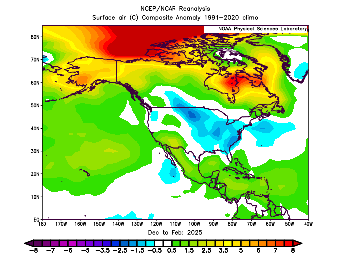
2025-2026 ENSO
donsutherland1 replied to 40/70 Benchmark's topic in Weather Forecasting and Discussion
Here's how the ECMWF seasonal forecasts changed: August 2025: September 2025: For perspective, here's where things stood last September for Winter 2024-2025, along with the actual outcome: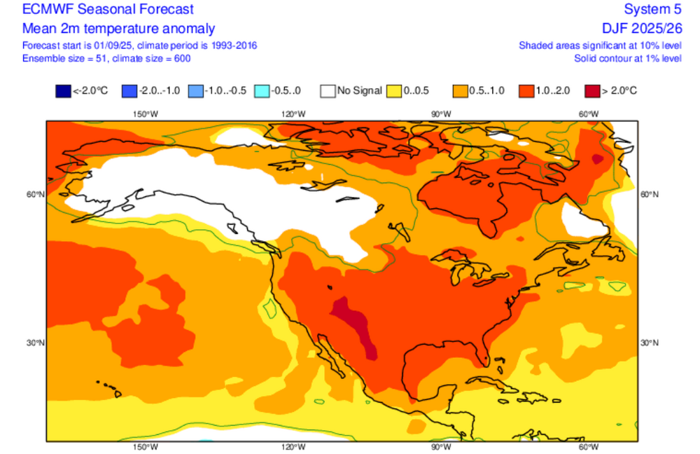

-
2025-2026 ENSO
donsutherland1 replied to 40/70 Benchmark's topic in Weather Forecasting and Discussion
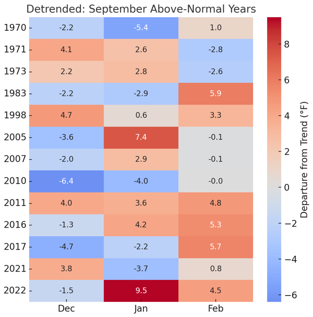
Good question. I posted the actual data, because even when the data is detrended for the warming, one still finds similar outcomes.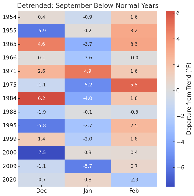
-
September 2025 OBS-Discussion centered NYC subforum
donsutherland1 replied to wdrag's topic in New York City Metro
In a welcome respite from the dry conditions, last night's rainfall overperformed the guidance in New York City. The one day rainfall for yesterday of 0.40" was the largest since 0.51" fell on August 20 and the two-day rainfall into this morning of 0.57" was the largest since August 20-21 when 0.78" fell. -
September 2025 OBS-Discussion centered NYC subforum
donsutherland1 replied to wdrag's topic in New York City Metro
At least it's not that dry. Phoenix is currently seeing blowing dust courtesy of an outflow boundary that is moving through: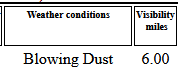
-
September 2025 OBS-Discussion centered NYC subforum
donsutherland1 replied to wdrag's topic in New York City Metro
Rainfall amounts have fizzled as the front moved toward New York City. Some amounts through 8:15 pm include: Newark: 0.02" (light rain) Sussex: 0.33" Trenton: 0.07" -
September 2025 OBS-Discussion centered NYC subforum
donsutherland1 replied to wdrag's topic in New York City Metro
Thunder has reached Newark. -
Occasional Thoughts on Climate Change
donsutherland1 replied to donsutherland1's topic in Climate Change
Great post. Like you, I believe evolutionary biology has a lot to do with how humans respond, including the preference for the status quo over change, and reactive responses over proactive ones. -
September 2025 OBS-Discussion centered NYC subforum
donsutherland1 replied to wdrag's topic in New York City Metro
Some showers are possible this evening into early tomorrow as a warm front moves across the region. Afterward, tomorrow and Saturday will be warmer days. Temperatures will top out in the lower and middle 80s before another cooler air mass moves into the region. A few of the warmer spots could top out in the upper 80s. Another round of showers or periods of rain is possible late Saturday into Sunday as a cold front crosses the region. Rainfall from the latter system will be more substantial than that which will occur overnight. The ENSO Region 1+2 anomaly was -0.3°C and the Region 3.4 anomaly was -0.4°C for the week centered around August 27. For the past six weeks, the ENSO Region 1+2 anomaly has averaged +0.33°C and the ENSO Region 3.4 anomaly has averaged -0.32°C. Neutral ENSO conditions will likely continue into early autumn. The SOI was +11.00 today. The preliminary Arctic Oscillation (AO) was +0.207 today. -
Occasional Thoughts on Climate Change
donsutherland1 replied to donsutherland1's topic in Climate Change
I suspect that human society will need to experience a crisis of a sufficiently large magnitude to break the inertia. Pandemics, wars, economic crises have all been able to shift the bias from inaction to action. But unless a crisis is sufficiently large to destabilize the business-as-usual paradigm and break faith in some future technological miracle that is used as an excuse for delay, it will be difficult to see significant progress. I don't believe a single weather event will suffice. One would likely see a degree of proactive reform on a local or regional scale, as opposed to the global scale required. Moreover, the response would likely be focused far more on adaptation than mitigation. After some passage of time, things would drift back toward business-as-usual. One sees a recent example in terms of growing financial system deregulation now that the 2008 financial crisis is fading from memory. I suspect the same thing would happen following a regional failed harvest, catastrophic flood, or lethal heat event. What might break the logjam would be recurring failed harvests on a large-scale, significant encroachment of rising seas into numerous major coastal cities, etc. Tragically, the human and social costs would be far higher under such circumstances than with any single event. -
Occasional Thoughts on Climate Change
donsutherland1 replied to donsutherland1's topic in Climate Change
From a scientific standpoint, such insight would be valuable. However, IMO, from a policy standpoint, it would be unlikely to matter much. Society has effectively chosen to stay the course. It has chosen to continue to rapaciously burn fossil fuels unleashing gigatons of CO2 into the atmosphere and kicking off a range of feedbacks. Neither the promise of cheaper, cleaner alternatives nor the staggering $7 trillion in annual fossil fuel subsidies has shifted policymakers’ calculus. Instead, emboldened by the applause of a loud minority of bad actors, they have doubled down on their intransigence. In the U.S., there is even a neo-Luddite effort underway to roll back progress on cleaner alternatives, amidst what appears to be a broad and accelerating split with science far beyond climate science. Although these policymakers seem to believe that their unyielding defense of fossil fuels will grant them immunity from the laws of physics, it won't. The laws of physics are not negotiable. Those laws will prevail regardless of human arrogance or ignorance. For scientists, there may be some comfort in knowing that their warnings were grounded in well-tested and well-proven principles. After all, well-understood laws played out exactly as they were understood. From a knowledge standpoint, that's a very good thing. In short, generations of scientists did their job. They did it well and they did it courageously. Full responsibility for the consequences will fall squarely on those who knowingly chose to maintain their unsustainable path in the face of clear warnings and insurmountable evidence. They will be the authors of a sea-level rise that could swallow tens of trillions of dollars of coastal land. They will be the ones who made that wholly avoidable outcome possible. Unlike the rapid sea-level rise around 8,000 BCE when prehistoric humans had no understanding of the forces at work, the ongoing rise during the 21st century and beyond will not be the result of uncontrollable or unknown circumstances. It will be the outcome of deliberate choice with complete knowledge of the consequences of that choice. -
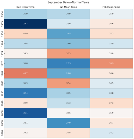
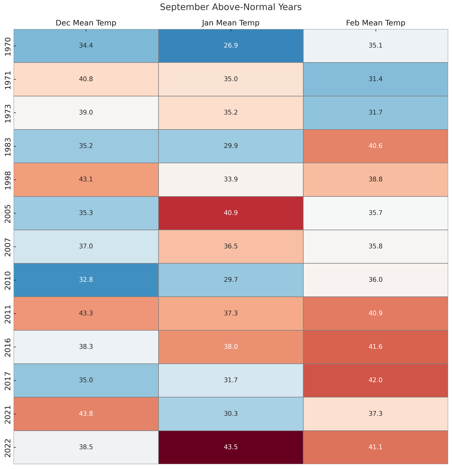
2025-2026 ENSO
donsutherland1 replied to 40/70 Benchmark's topic in Weather Forecasting and Discussion
Here's how La Niñas transition (using New York City's data) following cooler than normal and warmer than normal Septembers: In general, warmer Septembers are often followed by milder and less snowy winters. Cooler Septembers slightly favor colder winters (especially January, possibly due to more persistent forcing) with greater snowfall potential.