donsutherland1
-
Posts
23,988 -
Joined
Content Type
Profiles
Blogs
Forums
American Weather
Media Demo
Store
Gallery
Everything posted by donsutherland1
-
Most, but not all of the area is below normal so far. I suspect that the entire region will finish below normal once August concludes. NYC will be solidly below normal.
-
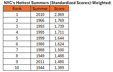
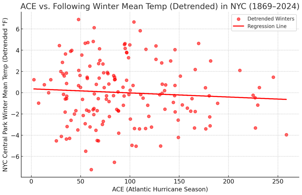
For Central Park, I included all summers from 1869-2024.
-
The temperature in Central Park has fallen to 59. August 2025 is the second consecutive August with at least one low temperature in the 50s. The last time that happened was August 2007 and August 2008.
-
The temperature in White Plains has now fallen into the 50s. That is the 7th day this month and the most during August 1-20 since 2013.
-
Occasional Thoughts on Climate Change
donsutherland1 replied to donsutherland1's topic in Climate Change
Phoenix is on track to record its fourth hottest summer on record. All four will have occurred since 2020. The ranking will be as follows: 1. 2024 2. 2023 3. 2020 4. 2025 -
11th June-August and 3rd if June-September is used.
-
The temperature peaked at 70° in Central Park. That was the coolest high temperature since June 17 when the high was 67°. Showers and periods of rain are likely into tomorrow. Most areas should see 0.50" or less of rain. However, some spots could see heavier rain. High temperatures will likely reach the lower and middle 70s tomorrow and then climb into the lower 80s on Friday through the weekend. The extended range guidance continues to suggest that the closing week of August could feature below normal temperatures. Precipitation could be near normal. There will be higher-than-climatological risk of at least one period in September with highs in the upper 80s or perhaps 90s. Summers similar to the current one have had September highs of 90 or above about 10 percentage points above that for all other years. The ENSO Region 1+2 anomaly was +0.6°C and the Region 3.4 anomaly was -0.3°C for the week centered around August 13. For the past six weeks, the ENSO Region 1+2 anomaly has averaged +0.53°C and the ENSO Region 3.4 anomaly has averaged -0.20°C. Neutral ENSO conditions will likely continue into early autumn. The SOI was -8.56 today. The preliminary Arctic Oscillation (AO) was -0.972 today. Based on sensitivity analysis applied to the latest guidance, there is an implied 84% probability that New York City will have a cooler than normal August (1991-2020 normal). August will likely finish with a mean temperature near 74.6° (1.5° below normal). Supplemental Information: The projected mean would be 0.6° below the 1981-2010 normal monthly value.
-
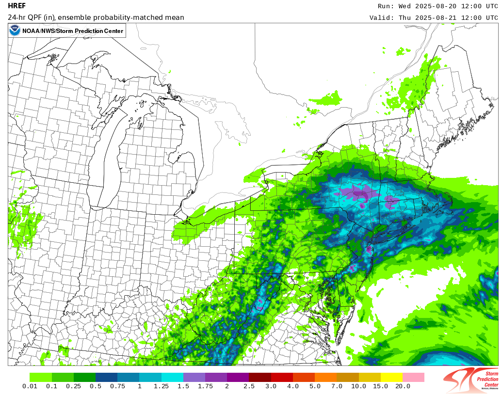
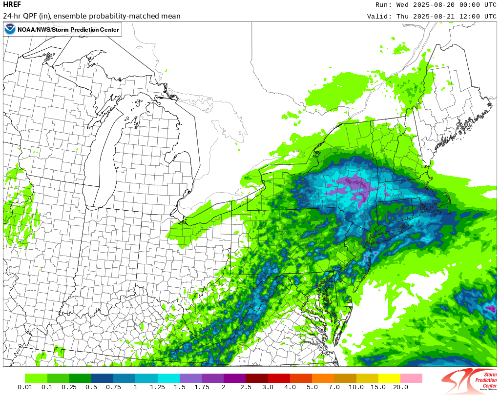
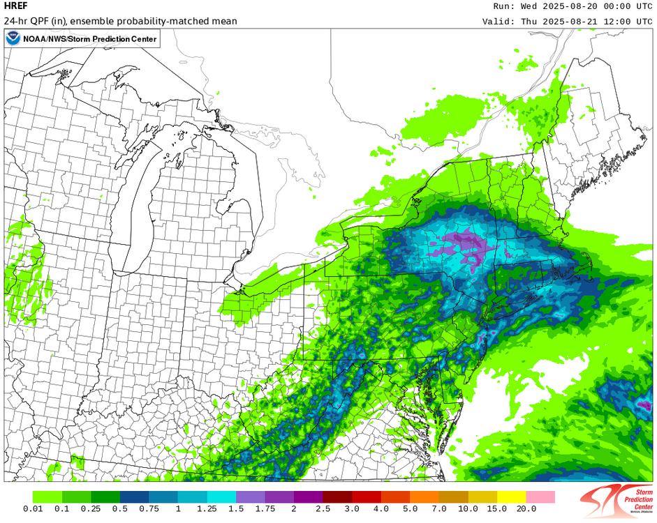
The 8/20 0z HREF:
-
A dramatic change to a sustained period of cooler weather has now occurred. High temperatures will likely reach the middle and upper 70s through Thursday and then the lower 80s on Friday through the weekend. Some showers or periods of rain are possible Wednesday afternoon into Thursday. Most of the region will see less than 0.50" or rain, though widely scattered areas of heavier rainfall are possible. The Jersey shore could see heavier rain and a gusty wind. The extended range guidance continues to suggest that the closing week of August could feature below normal temperatures. Precipitation could be near normal. The synoptic pattern should limit direct tropical cyclone threats for the foreseeable future. Impacts from elevated tides, surf, rip currents, and some showers or periods of rain would be the most likely effects produced by Erin as it tracks well offshore between the U.S. East Coast and Bermuda. There will be higher-than-climatological risk of at least one period in September with highs in the upper 80s or perhaps 90s. Summers similar to the current one have had September highs of 90 or above about 10 percentage points above that for all other years. The ENSO Region 1+2 anomaly was +0.6°C and the Region 3.4 anomaly was -0.3°C for the week centered around August 13. For the past six weeks, the ENSO Region 1+2 anomaly has averaged +0.53°C and the ENSO Region 3.4 anomaly has averaged -0.20°C. Neutral ENSO conditions will likely continue into early autumn. The SOI was -17.72 today. The preliminary Arctic Oscillation (AO) was -0.771 today. Based on sensitivity analysis applied to the latest guidance, there is an implied 80% probability that New York City will have a cooler than normal August (1991-2020 normal). August will likely finish with a mean temperature near 74.8° (1.3° below normal). Supplemental Information: The projected mean would be 0.4° below the 1981-2010 normal monthly value.
-
Occasional Thoughts on Climate Change
donsutherland1 replied to donsutherland1's topic in Climate Change
Yes, that’s correct. Phoenix has a pronounced UHI effect. One sees it particularly in the explosive increase in 90 or above low temperatures. -
A dramatic change to a sustained period of cooler weather has now occurred. High temperatures will likely reach the middle and upper 70s through Wednesday and then the lower 80s on Thursday and Friday. The extended range guidance continues to suggest that the closing week of August could feature below normal temperatures. Precipitation could be near normal. The synoptic pattern should limit direct tropical cyclone threats for the foreseeable future. Impacts from elevated tides, surf, and rip currents would be the most likely effects produced by Erin as it tracks well offshore between the U.S. East Coast and Bermuda. There will be higher-than-climatological risk of at least one period in September with highs in the upper 80s or perhaps 90s. Summers similar to the current one have had September highs of 90 or above about 10 percentage points above that for all other years. The ENSO Region 1+2 anomaly was +0.6°C and the Region 3.4 anomaly was -0.3°C for the week centered around August 13. For the past six weeks, the ENSO Region 1+2 anomaly has averaged +0.53°C and the ENSO Region 3.4 anomaly has averaged -0.20°C. Neutral ENSO conditions will likely continue into early autumn. The SOI was -4.73 today. The preliminary Arctic Oscillation (AO) was -0.721 today. Based on sensitivity analysis applied to the latest guidance, there is an implied 70% probability that New York City will have a cooler than normal August (1991-2020 normal). August will likely finish with a mean temperature near 75.2° (0.9° below normal). Supplemental Information: The projected mean would be at the 1981-2010 normal monthly value.
-
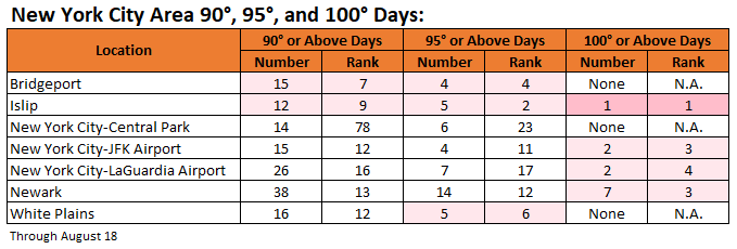
A cooler regime is now in place and it will remain in place for an extended period of time. Here's where things currently stand with respect to select high temperature thresholds for 2025:
-
Occasional Thoughts on Climate Change
donsutherland1 replied to donsutherland1's topic in Climate Change
Those findings aren't too surprising. The UHI Effect grows most rapidly when an area first begins to urbanize. From 1950-1980, Phoenix's population grew 6.9% per year (Phoenix metro area: 6.4% per year). Since 1980, Phoenix's population has been growing 1.7% per year (Phoenix metro area: 2.7% per year). Since 2000, those rates have slowed further to 1.0% per year and 2.0% per year respectively. Phoenix's suburbs are currently growing faster than the City. -
Central Park picked up 0.64" rain in an hour. While impressive, that was just half of the hourly record of 1.28" for August 17 that was set in 1974.
-
Occasional Thoughts on Climate Change
donsutherland1 replied to donsutherland1's topic in Climate Change
I've often noted that Phoenix's warmth is a combination of UHI and climate change. The scientific literature describes numerous impacts on the Southwest monsoon in a warmer climate, particularly a drier monsoon season, fewer rain events, and higher temperatures during monsoon season. This evolution is currently in its early stages. The outcome described in the literature won't happen all at once or uniformly. Phoenix deserves focused attention because it represents both an extreme case and an early signal of how climate change and aridification interact in the desert Southwest. Phoenix’s accelerated warming, even as UHI amplifies the impact of ongoing warming, makes it a valuable barometer of what other communities may face as aridification deepens across the state. -
Today saw hot temperatures across much of the region. Highs included: Bridgeport: 88° Islip: 86° New Haven: 89° New York City-Central Park: 91° New York City-JFK Airport: 85° New York City-LaGuardia Airport: 91° Newark: 94° White Plains: 89° A dramatic change to a sustained period of cooler weather now lies ahead. A cold front will cross the region this evening or tonight bringing some showers or thundershowers. In the wake of the frontal passage, noticeably cooler air will overspread the region. High temperatures will likely reach the upper 70s Monday through Wednesday and then the lower 80s on Thursday and Friday. The extended range guidance continues to suggest that the closing week of August could feature below normal temperatures. Precipitation could be near normal. The synoptic pattern should limit direct tropical cyclone threats for the foreseeable future. Impacts from elevated tides, surf, and rip currents would be the most likely effects produced by Erin as it tracks well offshore between the U.S. East Coast and Bermuda. The ENSO Region 1+2 anomaly was +0.8°C and the Region 3.4 anomaly was -0.3°C for the week centered around August 6. For the past six weeks, the ENSO Region 1+2 anomaly has averaged +0.50°C and the ENSO Region 3.4 anomaly has averaged -0.15°C. Neutral ENSO conditions will likely continue into early autumn. The SOI was +4.49 today. The preliminary Arctic Oscillation (AO) was -0.220 today. Based on sensitivity analysis applied to the latest guidance, there is an implied 66% probability that New York City will have a cooler than normal August (1991-2020 normal). August will likely finish with a mean temperature near 75.4° (0.7° below normal). Supplemental Information: The projected mean would be 0.2° above the 1981-2010 normal monthly value.
-
2025-2026 ENSO
donsutherland1 replied to 40/70 Benchmark's topic in Weather Forecasting and Discussion
Yes. I ran the numbers this morning to see what the coefficient of determination was. It is .0.0143. This was even lower than I had thought when I had run the scatter diagram earlier today. -
2025-2026 ENSO
donsutherland1 replied to 40/70 Benchmark's topic in Weather Forecasting and Discussion
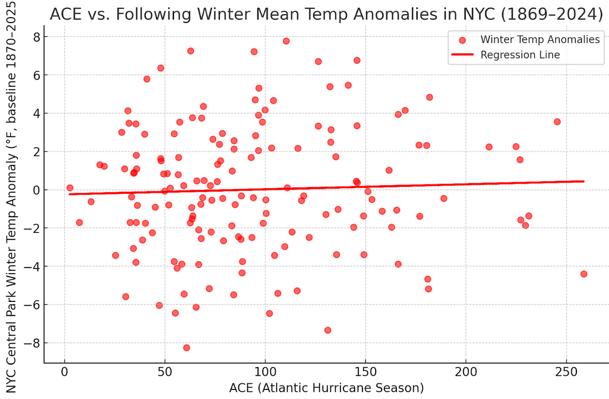
When it comes to ACE and winter temperatures (using NYC), the long-term warming already overwhelms the ACE. Here's what it looks like (anomalies are against the Winter 1869-70 through 2024-25 mean temperature for purposes of standardization): Here's what happens when one detrends the data for the ongoing warming (takes out the warming signal):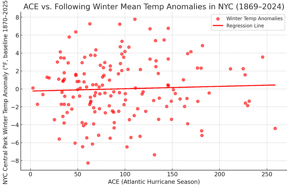
-
2025-2026 ENSO
donsutherland1 replied to 40/70 Benchmark's topic in Weather Forecasting and Discussion
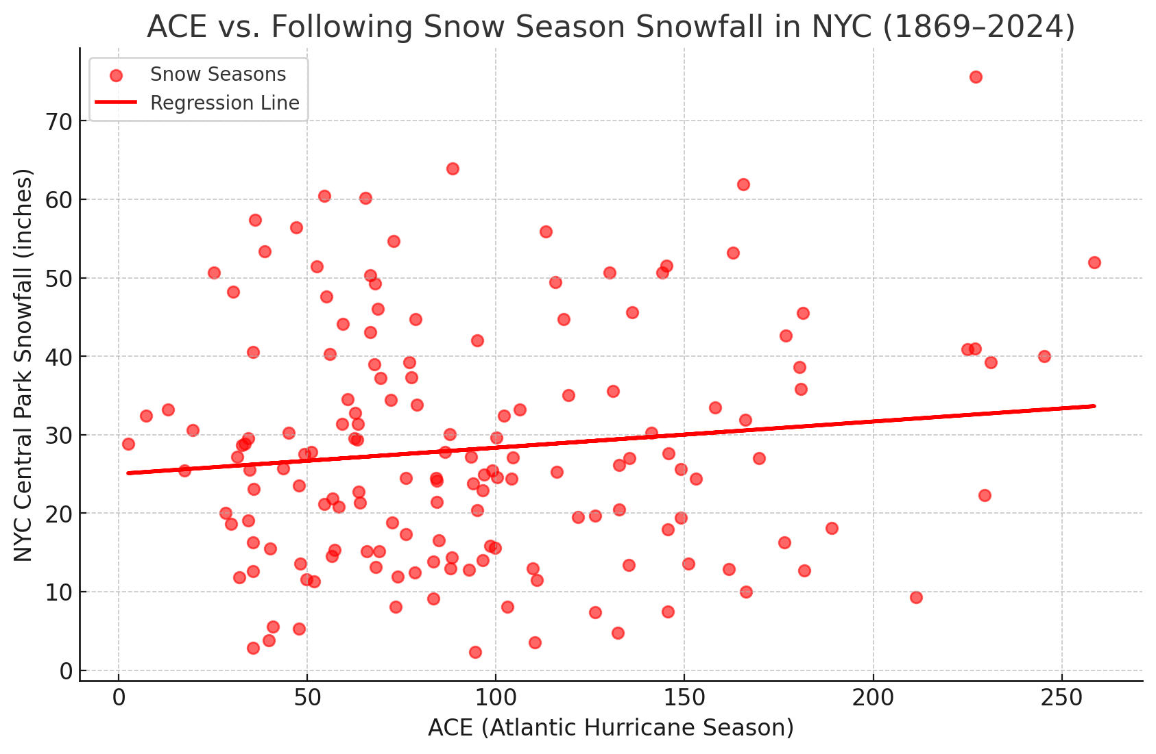
For NYC, the coefficient of determination for ACE and seasonal snowfall is just 0.014. -
2025-2026 ENSO
donsutherland1 replied to 40/70 Benchmark's topic in Weather Forecasting and Discussion
The ACE connection is somewhat positive but very noisy for Central Park.
-
Tomorrow will turn briefly warmer with highs reaching the upper 80s and lower 90s acros the region. Afterward, a shift toward cooler weather lies ahead. Noticeably cooler air will overspread the region tomorrow night and Monday. High temperatures will likely reach the upper 70s Monday through Wednesday and then the lower 80s on Thursday. The extended range guidance continues to suggest that the closing week of August could feature below normal temperatures. Precipitation could be near normal. The synoptic pattern should limit direct tropical cyclone threats for the foreseeable future. Impacts from elevated tides, surf, and rip currents would be the most likely effects produced by Erin as it tracks well offshore between the U.S. East Coast and Bermuda. The ENSO Region 1+2 anomaly was +0.8°C and the Region 3.4 anomaly was -0.3°C for the week centered around August 6. For the past six weeks, the ENSO Region 1+2 anomaly has averaged +0.50°C and the ENSO Region 3.4 anomaly has averaged -0.15°C. Neutral ENSO conditions will likely continue into early autumn. The SOI was -4.37 today. The preliminary Arctic Oscillation (AO) was +0.333 today. Based on sensitivity analysis applied to the latest guidance, there is an implied 57% probability that New York City will have a cooler than normal August (1991-2020 normal). August will likely finish with a mean temperature near 75.6° (0.5° below normal). Supplemental Information: The projected mean would be 0.4° above the 1981-2010 normal monthly value.
-
Occasional Thoughts on Climate Change
donsutherland1 replied to donsutherland1's topic in Climate Change
Three things: 1. The focus of my post was Phoenix's monsoon season where recent years have seen disappointing monsoon season outcomes. It was not intended to focus on all of Arizona's monsoon season. 2. The expected impacts of climate change for the Phoenix area were fewer rainfalls, lower monsoon season rainfall and a warming monsoon season. All three are present in Phoenix. 3. The Phoenix area, precisely because it has warmed faster than much of Arizona, could be a barometer of what lies ahead in coming decades as the climate continues to warm elsewhere in Arizona. Aridification won't have a uniform impact in Arizona. Indeed, a prior aridification regime might well have led to the demise of the Hohokam people who resided in the vicinity of where Phoenix is today. -
The hourly guidance showed mostly cloudy skies this morning. The clouds should break late morning/early afternoon yielding to partly sunny skies.