donsutherland1
-
Posts
23,988 -
Joined
Content Type
Profiles
Blogs
Forums
American Weather
Media Demo
Store
Gallery
Everything posted by donsutherland1
-
New Haven reached at least 89.
-
Parts of the region again saw temperatures reach 90° or above. Bridgeport, LaGuardia Airport, Newark, and White Plains all reached or exceeded 90°. Through August 13, Bridgeport has had 15 highs of 90° or above while Central Park has 13 such days. Bridgeport has never had a calendar year with more 90° highs than Central Park. The most anomalous heat remained in northern New England and parts of eastern Canada. Caribou reached 90° for an all-time record-tying fourth consecutive day with a daily record high of 94°. Its four-day average high temperature of 93.3° broke the old record of 92.8° from June 17-20, 2020. Goose Bay, NL had a provisional high of 97°, which set an August monthly record. Showers and thundershowers are likely into tomorrow. Some areas could see heavy downpours. Tomorrow through Friday will still be warm days. Temperatures will likely top out in the middle and upper 80s across the region. Saturday will likely be somewhat cooler before it turns briefly warmer on Sunday. Noticeably cooler air will likely overspread the region early next week. The ENSO Region 1+2 anomaly was +0.8°C and the Region 3.4 anomaly was -0.3°C for the week centered around August 6. For the past six weeks, the ENSO Region 1+2 anomaly has averaged +0.50°C and the ENSO Region 3.4 anomaly has averaged -0.15°C. Neutral ENSO conditions will likely continue into early autumn. The SOI was +4.43 today. The preliminary Arctic Oscillation (AO) was -0.563 today. Based on sensitivity analysis applied to the latest guidance, there is an implied 56% probability that New York City will have a cooler than normal August (1991-2020 normal). August will likely finish with a mean temperature near 75.8° (0.3° below normal). Supplemental Information: The projected mean would be 0.6° above the 1981-2010 normal monthly value.
-
Caribou has reached 90F (32.2C) for the fourth consecutive year. That ties the record for most such consecutive days. The record was set during June 15-18, 1949 and tied during July 25-28, 1963 and August 29-September 1, 2010.
-
Conceptually, it could be done. I suspect that reasons that such classifications have not been pursued are the additional elements of duration and nighttime temperatures that help define heatwave severity.
-
There are many variables that are involved. SSTAs could promote a tendency for ridging in various locations. Teleconnections could influence the positioning of such synoptic features. Rossby waves can also shape the development of the synoptic pattern.
-
Only 1983 did it.
-
The position of the ridge and how far north the jet stream is. The position of the ridge allows for some onshore flow in the NJ-NYC-CT areas. Miramichi, Caribou, Bangor, Burlington and Montreal were in prime spots for maximum heating.
-
Miramichi is inland. It isn’t affected by the sea breeze.
-
Near record and record heat again covered parts of Upstate New York, northern New England, Ontario, Quebec, New Brunswick, and Nova Scotia. Preliminary highs: Bangor: 97° Boston: 90° Buffalo: 91° Burlington: 98° (new daily record) Caribou: 94° (new daily record) Concord: 95° Gaspé, QC: 97° (new all-time record) Manchester: 94° Miramichi, NB: 101° (new all-time record) Montreal: 94° (new daily record) New York City-Central Park: 91° New York City-LaGuardia Airport: 91° Newark: 92° Ottawa: 95° Plattsburgh: 92° (new daily record) Portland: 90° Tomorrow and Thursday will be very warm days. Temperatures will likely reach or exceed 90° in parts of the area. Aside from some showers or thundershowers Wednesday night into Thursday morning, mainly dry conditions will likely persist through at least the next weekend. The guidance continues to step down toward a cooler period following next weekend. The weekly guidance suggests that the remainder of the months will be close to normal. As a result, of the cooling of the extended guidance, the sensitivity analysis has flipped toward a slightly cooler than normal outcome for the month overall. The ENSO Region 1+2 anomaly was +0.8°C and the Region 3.4 anomaly was -0.3°C for the week centered around August 6. For the past six weeks, the ENSO Region 1+2 anomaly has averaged +0.50°C and the ENSO Region 3.4 anomaly has averaged -0.15°C. Neutral ENSO conditions will likely continue into early autumn. The SOI was -10.80 yesterday. The preliminary Arctic Oscillation (AO) was -0.492 today. Based on sensitivity analysis applied to the latest guidance, there is an implied 53% probability that New York City will have a cooler than normal August (1991-2020 normal). August will likely finish with a mean temperature near 75.9° (0.2° below normal). Supplemental Information: The projected mean would be 0.7° above the 1981-2010 normal monthly value.
-
No. The 82 was the only high of 80 or above and just the third 80 or above high on record for November.
-
2025-2026 ENSO
donsutherland1 replied to 40/70 Benchmark's topic in Weather Forecasting and Discussion
The IOD has been declining in recent months and has already turned negative. It seems that things are on track for the forecast.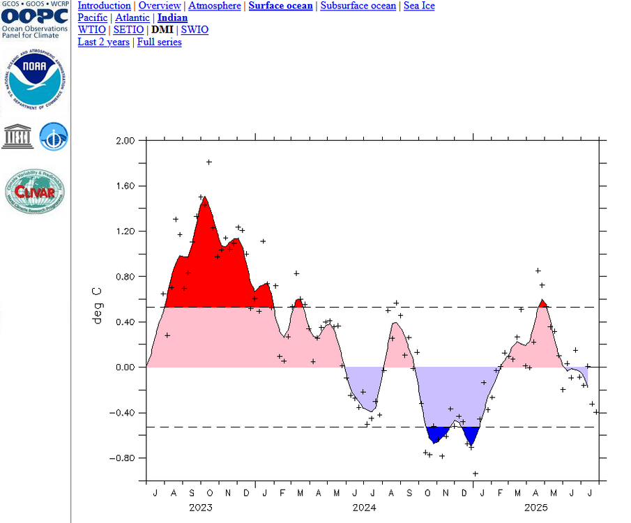
-
Temperatures rose into the upper 80s and even lower 90s across the region. Far more impressive heat covered upstate New York, northern New England, southern Quebec, and New Brunswick. Near record to record highs were commonplace. Highs included: Bangor: 96° Buffalo: 91° Burlington: 96° Caribou: 94° (old record: 92°, 2020) Concord: 97° Manchester: 96° Plattsburgh: 91° (tied record set in 1970) Saranac Lake: 90° Miramichi, NB hit 99°. That is its second highest temperature on record. Montreal also topped out at 94°. Tomorrow through Thursday will be hot days across the region. Temperatures could top out in the lower and middle 90s in the hot spots. Aside from some showers or thundershowers Wednesday night into Thursday morning, mainly dry conditions will likely persist through at least the next weekend. The guidance continues to step down toward a cooler period following next weekend. The ENSO Region 1+2 anomaly was +0.8°C and the Region 3.4 anomaly was -0.3°C for the week centered around August 6. For the past six weeks, the ENSO Region 1+2 anomaly has averaged +0.50°C and the ENSO Region 3.4 anomaly has averaged -0.15°C. Neutral ENSO conditions will likely continue into early autumn. The SOI was -10.80 today. The preliminary Arctic Oscillation (AO) was -0.449 today. Based on sensitivity analysis applied to the latest guidance, there is an implied 51% probability that New York City will have a warmer than normal August (1991-2020 normal). August will likely finish with a mean temperature near 76.2° (0.1° above normal). Supplemental Information: The projected mean would be 1.0° above the 1981-2010 normal monthly value.
-
Temperatures topped out several degrees above the guidance today, in part to abnormally dry conditions. The region is off to its driest starrt to August since 2010. During the first 10 days of August, the combined total precipitation for Bridgeport, Islip, Central Park, JFK Airport, LaGuardia Airport, and Newark is 0.23". That is the lowest figure since August 1-10, 2010 when just 0.13" was measured. In stark contrast, August 1-10, 2024 had already seen 23.25" of rain. Aside from some showers or thundershowers Wednesday night into Thursday morning, mainly dry conditions will likely persist through at least the next weekend. The ongoing warming trend will continue. The region will likely experience a return of 90° or above heat this week. Newark already reached 90° today for the 32nd time this year. LaGuardia Airport also reached 90°. Temperatures could top out in the middle or perhaps even upper 90s in the hot spots when the heat peaks during the Tuesday through Thursday period. The ENSO Region 1+2 anomaly was +0.4°C and the Region 3.4 anomaly was -0.3°C for the week centered around July 30. For the past six weeks, the ENSO Region 1+2 anomaly has averaged +0.37°C and the ENSO Region 3.4 anomaly has averaged -0.08°C. Neutral ENSO conditions will likely continue through the summer. The SOI was -14.51 today. The preliminary Arctic Oscillation (AO) was -0.173 today. Based on sensitivity analysis applied to the latest guidance, there is an implied 53% probability that New York City will have a warmer than normal August (1991-2020 normal). August will likely finish with a mean temperature near 76.4° (0.3° above normal). Supplemental Information: The projected mean would be 1.2° above the 1981-2010 normal monthly value.
-
2025-2026 ENSO
donsutherland1 replied to 40/70 Benchmark's topic in Weather Forecasting and Discussion
A bigger problem is meteorologists such as JB posting such graphics. In his case, he’s arguing that the odds favor landfall. Everything I have seen suggests otherwise—maybe a 2-in-3 likelihood of recurvature. It’s early, still. But that is where things stand with Invest 97. -
Temperatures in the greater New York City area have exceeded the guidance this afternoon, in part due to the driest start to August since 2010. Newark reached 90 for the 32nd time this year.
-
Yesterday’s 5.74” at Milwaukee was its second highest daily amount on record. Six of the top ten daily rainfalls have occurred since 2000. Records go back to 1871.
-
Central Park finished the August 1-10 with 9 low temperatures below 70°. The last time that happened was August 2017. The August 1-10, 2025 average low of 65.2° was the lowest August 1-10 average since 1992 when the mean low was 64.4°.
-
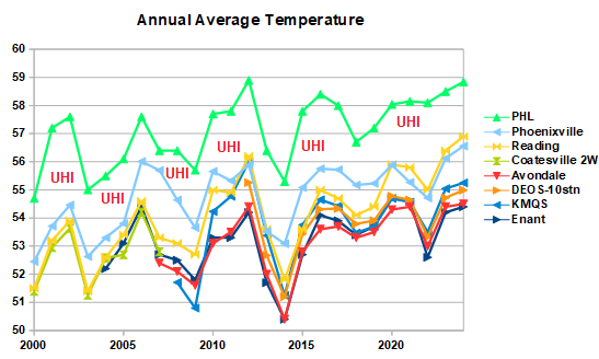
2011 had it largest impacts on the August and September trends (1970-2024).

-
Occasional Thoughts on Climate Change
donsutherland1 replied to donsutherland1's topic in Climate Change
Yes, Antarctic ice cores show that the temperature rose shortly before CO2 started rising by centuries to 1,000 years. The initial warming was triggered by changes in the Earth's orbit, which allowed for an increase in solar insolation. As oceans warmed, CO2 was released (the outgassing you mentioned). The released CO2 then drove a continuation of the warming. Today, humanity has bypassed Milankovitch Cycles, which once served as the trigger for the initial warming. Humanity began reintroducing CO2 to the atmosphere via the burning of fossil fuels. As atmospheric CO2 has increased, that has driven temperatures higher. In terms of incoming solar radiation, a 3.7 W/m² increase in forcing (just over 1%) may seem small. But it's the imbalance that matters. For example, during the last ice age, there was a -3.9 W/m² imbalance (1.1%). Nevertheless, the latest research now suggests that the Last Glacial Maximum was about -6.1°C cooler than current temperatures. Regarding the recent 4.8°C estimate, I need to see more. I am open to it, because highly respected scientists in the field are now suggesting that climate sensitivity could be higher than consensus estimates when a better understanding of feedbacks is considered. I will watch the evolution of the debate and incoming data on this matter. Finally, I think there's a world of difference between one's having honest questions (your case) and those pontificating on the matter when they provide no credible alternative explanations and/or have done no research whatsoever on climate/climate change. -
Occasional Thoughts on Climate Change
donsutherland1 replied to donsutherland1's topic in Climate Change
That post was from six years ago. Science has continued to advance since then. Confidence in the anthropogenic driver for the current warming has increased since then. The general ideas from that post remain largely accurate and have stood up quite well. That's a testament to the scientific work on which they were based. In general, credible science holds up over time, especially when basic physics is involved. The properties of CO2 have been understood since the 19th Century. There is some nuance as it applies to central Antarctica where the surface is typically colder than the stratosphere. One paper suggests that there is a "negative greenhouse effect" that is unique to that region. The paper also makes clear that this is an exception that does not raise serious questions about the role of greenhouse gases in the warming of the Earth's climate. The paper states: It is important to note that these results do not contradict the key statements of the Intergovernmental Panel on Climate Change (IPCC) ..., namely, the well-known warming effect that CO₂ has on the Earth’s climate. Yet we showed that for the cold Antarctic continent some care needs to be taken when discussing the direct warming effect of CO₂. CO2 has not doubled from the pre-industrial level (it reached 430 ppm earlier this year vs. the pre-industrial figure of around 270 ppm -280 ppm). There are numerous feedbacks. Aerosols have gained some increased attention recently from some work by Hansen et al. The reduction in aerosols has limited the masking of warming and likely contributed, in part, to the recent acceleration in the rate of warming. A reduction in aerosols likely also contributed to the cloud-related changes that have been observed, but paleoclimate work suggests that more than aerosol changes are involved. A growing body of evidence strengthens the argument that clouds have a positive feedback, namely that at higher CO2 levels, cloud-related changes amplify the warming. Back in 2019, there were some who still argued that clouds would be a negative feedback and help reduce the rate of warming. That idea has now largely lost merit. Paleoclimate work by Jessica Tierney among others revealed that cloud-related changes at higher levels of CO2 enhanced warming. Recent data from NASA confirms changes to clouds consistent with promoting increased warming. Indeed, even more recent research on climate sensitivity has suggested that perhaps the CMIP6 models weren't "running hot" as initially thought, but that they might be doing a better job capturing cloud-related changes. A new paper, aside from Hansen's recent work, has suggested that climate sensitivity for a doubling of CO2 may be around 4.8°C based on the Pliocene Epoch. I'm not yet sold on that, but am open to this idea. I didn't state or suggest that the climate system will spiral out-of-control so to speak from ongoing anthropogenic warming. No runaway greenhouse effect is likely on Earth. That won't happen until the sun starts moving into its red giant phase as it begins to exhaust its hydrogen and begins to boil away the oceans. My point is that clear scientific understanding of climate change now exists concerning what is happening (warming) and why it is happening (antropogenic greenhouse gas emissions). The scientific debate over those two issues is finished. No credible alternative hypothesis exists. Nevertheless, that does not mean that there is anything close to perfect understanding. There remain some uncertainties, but those don't rise to the level of undermining the basic idea of anthropogenic warming. Feedbacks are real. Some amplify the warming as CO2 increases, while others damp the warming. Climate change has increased the frequency, magnitude, and duration of extreme heat events in the United States and worldwide. Evidence suggests that quasi-resonant amplification is contributing to the kind of "stuck patterns" that have led to long-duration severe heat outbreaks in parts of North America, Europe, Asia, and Africa, among other extreme events. Recent research also suggests that Pacific-related changes are creating a negative PDO-type scenario, which is contributing to the Southwest's growing hotter and drier. Finally, internal variability occurs within the context of increasing anthropogenic greenhouse gas forcing. Thus, there can be cold periods, including cold winters. Synoptic events also occur within the context of increasing anthropogenic forcing, so climate change impacts such events but does not necessarily cause them. Second order effects can see climate change driving changes in synoptic scale events e.g., aridification of regions can feed back into the development of more persistent and larger heat domes. -
You're correct. I took a look since 1970 when the current wetter regime (cyclical + climate change-forced) developed. August has grown wetter than any other month since then. Here are the per century trends.
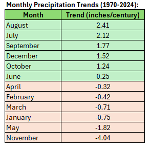
-
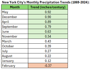
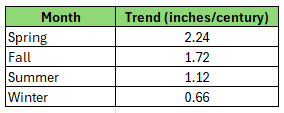
Actually, even as August has been growing much wetter since 1970, it has been growing wetter at a slower pace than many other months over New York City's historical period. Spring and fall are growing wetter at the fast pace. Winter is growing wetter at the slowest pace.
-
This morning, the temperature fell to 64° in Central Park. That was the fourth consecutive day with a low of 64°. The last time that happened during the first ten days of August was August 5-8, 1997. August 1-9 has had a mean low temperature of 64.8°. That is the coolest average low during that period since 1992 when the mean low was 64.0°. Overall, the August 1-9 mean temperature of 73.4° is the coolest since 1992 when the mean temperature was 73.3°. It will turn warmer tomorrow. The region will likely experience a return of 90° or above heat next week. Temperatures could top out in the middle or perhaps even upper 90s in the hot spots when the heat peaks during the Tuesday through Thursday period. The ENSO Region 1+2 anomaly was +0.4°C and the Region 3.4 anomaly was -0.3°C for the week centered around July 30. For the past six weeks, the ENSO Region 1+2 anomaly has averaged +0.37°C and the ENSO Region 3.4 anomaly has averaged -0.08°C. Neutral ENSO conditions will likely continue through the summer. The SOI was +0.06 today. The preliminary Arctic Oscillation (AO) was +0.305 today. Based on sensitivity analysis applied to the latest guidance, there is an implied 53% probability that New York City will have a warmer than normal August (1991-2020 normal). August will likely finish with a mean temperature near 76.4° (0.3° above normal). Supplemental Information: The projected mean would be 1.2° above the 1981-2010 normal monthly value.
-
This isn't surprising when one makes an "Apples-to-Apples" comparison. Philadelphia's heat island is relatively mature. So one sees a relatively constant UHI effect (I illustrated it below on the graph you created) amidst the year-to-year variability and a similar longer-term trend in temperatures. Most or virtually all of the recent warming is from climate change, as one would expect when a heat island is mature. Reading is likely exhibiting a faster warming trend, as it has seen very rapid population growth (proxy for an expanding heat island that is amplifying its warming trend) since 2000 (population +350% 2000-24) relative to Philadelphia, which has seen a 3.7% increase in population over that same period.
-
Occasional Thoughts on Climate Change
donsutherland1 replied to donsutherland1's topic in Climate Change
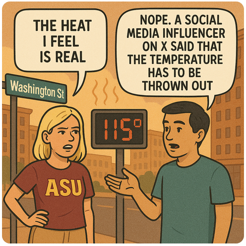
This essentially captures the X-based campaign to discredit Phoenix's August monthly high temperature record from August 7. It was a good test of GPT-5: