-
Posts
23,891 -
Joined
Content Type
Profiles
Blogs
Forums
American Weather
Media Demo
Store
Gallery
Everything posted by donsutherland1
-

July 2025 Discussion-OBS - seasonable summer variability
donsutherland1 replied to wdrag's topic in New York City Metro
Showers and heavy thunderstorms will affect parts of the region into early tomorrow morning. North and west of New York City will likely see a general 1"-3" of rain with locally higher amounts exceeding 4". Already, Scranton has picked up 2.32" of rain through 4:41 pm today. That breaks the daily record of 1.69" from 2017. That is also the 20th highest daily rainfall for any day in July. Heavy rain was also falling at Newark with 0.43" over the past 41 minutes. It will turn somewhat warmer tomorrow with temperatures rising through Thursday or Friday. The heat will likely peak on Thursday and Friday with highs topping out in the upper 80s and perhaps lower 90s. A warm and mainly dry weekend will follow. No widespread and sustained excessive or record-challenging heat appears likely through the first three weeks of July. The ENSO Region 1+2 anomaly was +0.4°C and the Region 3.4 anomaly was 0.1°C for the week centered around July 9. For the past six weeks, the ENSO Region 1+2 anomaly has averaged +0.52°C and the ENSO Region 3.4 anomaly has averaged +0.07°C. Neutral ENSO conditions will likely continue through the summer. The SOI was +1.05 today. The preliminary Arctic Oscillation (AO) was +0.077 today. Based on sensitivity analysis applied to the latest guidance, there is an implied 74% probability that New York City will have a warmer than normal July (1991-2020 normal). July will likely finish with a mean temperature near 79.2° (1.7° above normal). -
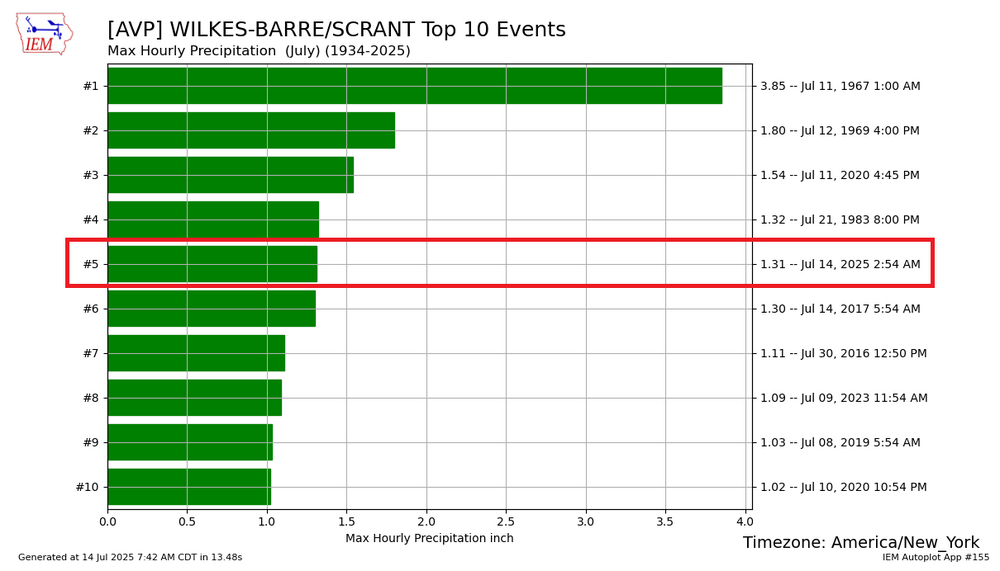
Earlier this morning, Scranton picked up 1.31" of rain in an hour. Its daily rainfall is currently approaching the daily mark of 1.69" that was set in 2017. So far, 3 S Equinunk, PA has picked up 5.50" of rain today.
-

July 2025 Discussion-OBS - seasonable summer variability
donsutherland1 replied to wdrag's topic in New York City Metro
Tomorrow will be variably cloudy and warm with readings generally in the lower 80s. A warm front will cross the region tomorrow night and Tuesday with some showers and thundershowers. Some locations have the potential to receive excessive amounts of rain. Afterward, it will turn somewhat warmer. The heat will likely peak on Thursday and Friday with highs topping out in the upper 80s and perhaps lower 90s. A warm weekend will follow. No widespread and sustained excessive or record-challenging heat appears likely through the first three weeks of July. The ENSO Region 1+2 anomaly was +0.4°C and the Region 3.4 anomaly was 0.0°C for the week centered around July 2. For the past six weeks, the ENSO Region 1+2 anomaly has averaged +0.58°C and the ENSO Region 3.4 anomaly has averaged +0.03°C. Neutral ENSO conditions will likely continue through the summer. The SOI was +16.68 Friday. The preliminary Arctic Oscillation (AO) was +0.219 today. Based on sensitivity analysis applied to the latest guidance, there is an implied 79% probability that New York City will have a warmer than normal July (1991-2020 normal). July will likely finish with a mean temperature near 79.2° (1.7° above normal). -

2025-2026 ENSO
donsutherland1 replied to 40/70 Benchmark's topic in Weather Forecasting and Discussion
In theory, yes. But the Arctic is warming faster than the mid-latitudes and the deep cold pool is shrinking. That’s reducing the coverage of cold anomalies even against a warmer baseline. -

2025-2026 ENSO
donsutherland1 replied to 40/70 Benchmark's topic in Weather Forecasting and Discussion
Good studies. I suspect that the warming of the West Pacific is having an impact on the polar vortex. Arctic outbreaks remain possible and it is plausible that they can, at times, penetrate farther south than they had in the past. However, because the deep cold pool is smaller than it was prior to 2000, in general, the cold shots tend not to be as expansive or as prolonged as they once were absent a "stuck pattern." That's why the overall coverage of cold anomalies is typically less than it was during earlier winters (e.g., February 1979 vs. February 2015) and the only nationwide winter among the top 30 coldest winters among the 2000s was 2009-10. -

July 2025 Discussion-OBS - seasonable summer variability
donsutherland1 replied to wdrag's topic in New York City Metro
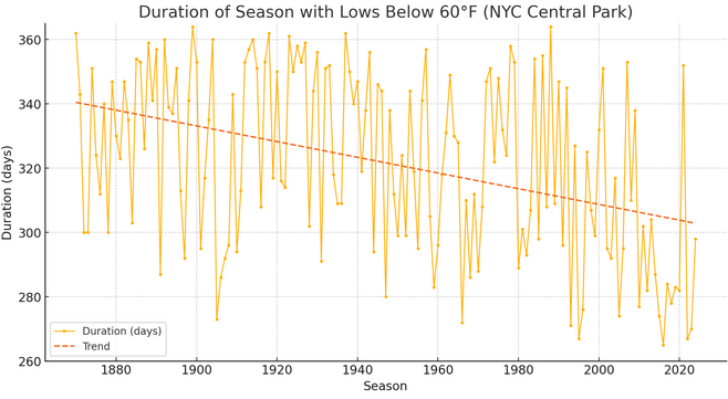
Below is the change in interval between the first and last date in the 50s for New York City (Central Park): Recent Seasons: 2020-21 season: First low below 60°F: September 14, 2020 Last low below 60°F: June 23, 2021 2021-22 season: First low below 60°F: July 3, 2021 Last low below 60°F: June 20, 2022 2022-23 season: First low below 60°F: September 16, 2022 Last low below 60°F: June 10, 2023 2023-24 season: First low below 60°F: September 15, 2023 Last low below 60°F: June 11, 2024 2024-25 season: First low below 60°F: August 21, 2024 Last low below 60°F: June 15, 2025 -

Occasional Thoughts on Climate Change
donsutherland1 replied to donsutherland1's topic in Climate Change
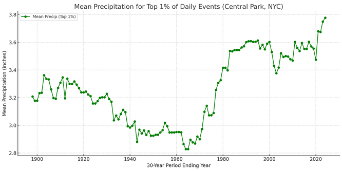
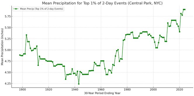
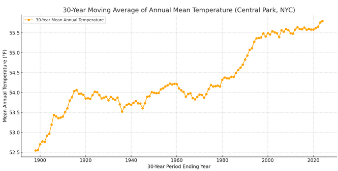
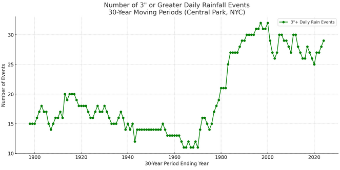
For illustrative purposes, I ran the numbers for New York City's Central Park (long climate record that goes back to 1869) to examine the connection between temperature and extreme rainfall events. Here are New York City's extreme rainfall events (top 1%) over one day and two days (overlapping two-day events are not double counted; the higher two-day rainfall is retained while the lower one is dropped, as the focus is on extreme events): Mean 30-Year Moving Average Temperature: The Clausius-Clapeyron Equation suggests that the atmosphere holds approximately 7% more water vapor for each 1°C increase in temperature. Therefore, one would expect a meaningful coefficient of determination between temperature and extreme rainfall amounts. That's exactly what one finds. The coefficient of determination between temperature and the top 1% daily rainfall events is 0.47. For the top 1% 2-day events, it is 0.48. That means that temperature explains 47% and 48% of such events respectively with warmer temperatures translating into more frequent and/or intense extreme rainfall events (this analysis dealt with intensity of events). That's almost half of the outcome for such events. It is also what one would expect from the basic physics expressed through the Clausius-Clapeyron Equation. What about the frequency of extreme events (measured here as daily precipitation of 3" or more)? The chart is displayed below. The coefficient of determination is much higher. It is 0.67. That means temperature explains two-thirds of the change/frequency in daily extreme precipitation events. Additional factors involved in the frequency and intensity of such events include, but are not limited to ENSO, teleconnections, storm tracks, local/mesoscale dynamics, and land-use effects. Nevertheless, temperature, alone, is a major variable. Any arguments made over Social Media that the warming climate plays virtually no role in the observed increase in extreme precipitation events (intensity and frequency) have no scientific merit. Not surprisingly, repeated attribution studies have found a direct connection to climate change where such events become more frequent and more intense, again consistent with the basic physics. -

July 2025 Discussion-OBS - seasonable summer variability
donsutherland1 replied to wdrag's topic in New York City Metro
The weekend will conclude on a warm note tomorrow. Temperatures will top out mainly the lower and middle 80s through the weekend. Another round of heat could develop early next week with temperatures returning to the upper 80s and perhaps lower 90s. No widespread and sustained excessive or record-challenging heat appears likely through the first three weeks of July. The ENSO Region 1+2 anomaly was +0.4°C and the Region 3.4 anomaly was 0.0°C for the week centered around July 2. For the past six weeks, the ENSO Region 1+2 anomaly has averaged +0.58°C and the ENSO Region 3.4 anomaly has averaged +0.03°C. Neutral ENSO conditions will likely continue through the summer. The SOI was +16.68 yesterday. The preliminary Arctic Oscillation (AO) was +0.613 today. Based on sensitivity analysis applied to the latest guidance, there is an implied 74% probability that New York City will have a warmer than normal July (1991-2020 normal). July will likely finish with a mean temperature near 79.2° (1.7° above normal). -

Winter cancelled/uncancelled banter 25/26
donsutherland1 replied to Rjay's topic in New York City Metro
-

Occasional Thoughts on Climate Change
donsutherland1 replied to donsutherland1's topic in Climate Change
That's why one should refer to the literature rather than social media tweets or opinion pieces from individuals who are not only outside the field, but working for organizations with interests that run counter to the science. The Martz op-ed provided earlier in this thread offers a classic example of the flaws inherent in doing so. His primary interest was to claim that climate change is not leading to an increase in extreme rainfall events. He never appropriately addressed the actual question. The piece is deeply flawed, ranging from lack of transparency to bad methodology. Six issues: 1. The piece revealed unfamiliarity with the literature, both papers and attribution studies. In fact, no literature was referenced. 2. The piece showed an absence of basic physical knowledge, namely when it comes to application of the Clausius-Clapeyron Equation that shows a direct relationship between increased temperature and increased capacity of the atmosphere to hold water vapor (approximately a 7% increase in water vapor capacity for every 1°C increase in temperatures). 3. Lack of awareness of recent very high Precipitable Water (PWAT) values in areas hit by excessive rainfalls (as would be predicted by the C-C equation). 4. Overgeneralization: He took 21 COOPs (unnamed) and suggested that they represent all of Texas. A more nuanced and specific description was needed. 5. The failure to name the COOPs deprives the exercise of transparency and makes reproducibility impossible. 6. Use of highest daily rainfall each year and reference to "unprecedented" events: An ability to identify the appropriate information for addressing research questions e.g., whether extreme rainfall events have increased, is essential to addressing those questions. There was a mismatch between what he looked at and the question involved. Extreme rainfall events are not equally distributed each year. Some years have clusters of such events. Others have none. The Martz approach gave all years equal weight and excluded numerous extreme rainfall events. His approach produced no useful information for addressing the question. These flaws are fatal. If one is seeking to contradict the literature, the evidence needs to be particularly strong and specific to the research question(s) involved. To be credible, the findings need to be reproducible, therefore, transparency of methods is of paramount importance. -

Winter cancelled/uncancelled banter 25/26
donsutherland1 replied to Rjay's topic in New York City Metro
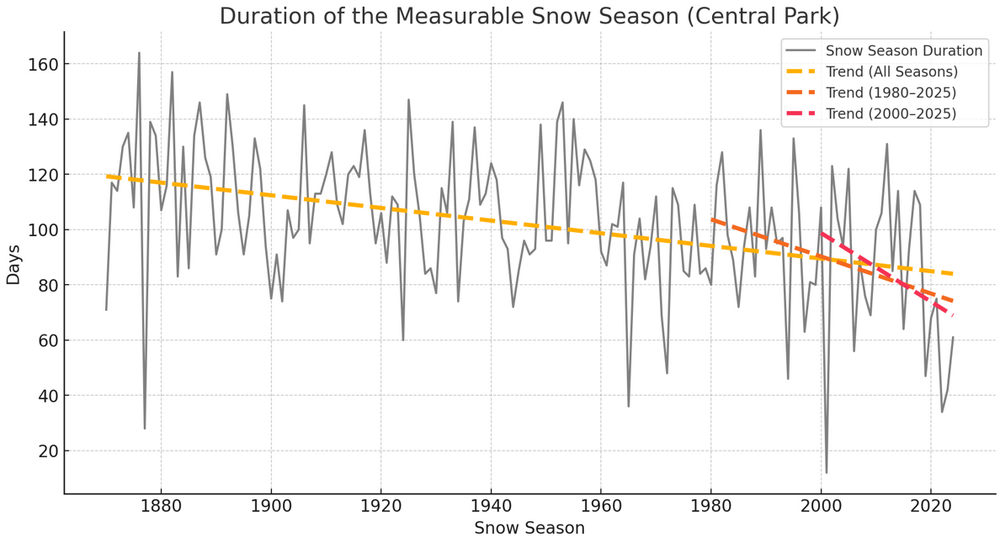
Earlier, even as winter is still in the distance, there had been some discussion about NYC's snowfalls. Discussion concerned the potential for a structural decline in seasonal snowfall averages. Another way to look at the risk is to examine snow season duration (duration in days between the first and last measurable snowfall). From 1869-70 through 2024-25, the duration has been shrinking 2.3 days per decade. Since 1979-80, as temperatures began a more rapid warming, the duration has been shrinking at a rate of 6.7 days per decade. Since 1999-00, that rate of shrinkage has increased to 12.4 days per decade. This rapid shortening of the snow season means that bigger snowfalls are needed to maintain seasonal averages. Moreover, the shrinkage in the snow season may be sufficiently fast that it is outweighing any benefits from greater moisture that a warmer atmosphere might provide. This accelerating reduction in snow season duration may provide a further hint that the recent low snowfall seasons are the start of a structural decline in seasonal snowfall, not merely a bad cycle, as the slopes coincide with rapid winter warming. It should be noted that there will continue to be snowy winters and also lengthier snow seasons. -

July 2025 Discussion-OBS - seasonable summer variability
donsutherland1 replied to wdrag's topic in New York City Metro
I suspect that had society gone down the very gradual path of phaseout beginning around 1995-2000 when the issue first gained clarity, considerable progress could have been made. Had society pursued the effort along the lines of a Manhattan or Apollo Project, I suspect substantial and rapid progress would have occurred. Those pathways were foregone. I do agree that nuclear power is part of the solution. I'd also like to see a really aggressive R&D project into fusion, as it offers the greatest potential in the medium- and long-term. -

July 2025 Discussion-OBS - seasonable summer variability
donsutherland1 replied to wdrag's topic in New York City Metro
JFK has been warmer than Central Park on a number of occasions in July. The last such time was 2009 (JFK: 73.68° and Central Park: 73.66°) The largest difference was 0.3° in 1969 (JFK: 75.0° and Central Park: 74.7°). It's only happened during cool July cases. 2025 would be the first very warm July case where JFK was warmer. -

July 2025 Discussion-OBS - seasonable summer variability
donsutherland1 replied to wdrag's topic in New York City Metro
The first 10 days of July have been very warm across the New York City area. New York City-Central Park: 79.0° (27th warmest) New York City-JFK Airport: 79.7° (8th warmest) New York City-LaGuardia Airport: 81.0° (11th warmest) Newark: 82.2° (7th warmest) Mean monthly temperatures for cases with July 1-10 mean temperatures at or above the 2025 figures ere as follows: New York City-Central Park: 78.8° New York City-JFK Airport: 78.4° New York City-LaGuardia Airport: 81.1° (8th warmest) Newark: 80.8° Warm weather will continue through the weekend with temperatures reaching mainly the lower and middle 80s through the weekend. Some of the guidance suggests that another round of heat could develop early next week with temperatures returning to the upper 80s and perhaps lower 90s. No widespread and sustained excessive heat appears likely through mid-July. The ENSO Region 1+2 anomaly was +0.4°C and the Region 3.4 anomaly was 0.0°C for the week centered around July 2. For the past six weeks, the ENSO Region 1+2 anomaly has averaged +0.58°C and the ENSO Region 3.4 anomaly has averaged +0.03°C. Neutral ENSO conditions will likely continue through the summer. The SOI was +16.68 today. The preliminary Arctic Oscillation (AO) was +0.962 today. Based on sensitivity analysis applied to the latest guidance, there is an implied 70% probability that New York City will have a warmer than normal July (1991-2020 normal). July will likely finish with a mean temperature near 79.0° (1.5° above normal). -

July 2025 Discussion-OBS - seasonable summer variability
donsutherland1 replied to wdrag's topic in New York City Metro
The Polynesian civilization prior to the arrival of Europeans in the early 18th century. I suspect that today’s teens will be among the leading edge of a generation or generations that won’t view fossil fuels as indispensable and will see the vast planet-scale harm they have inflicted and then will move aggressively to curb their burning, even if the short-term effect is disruptive.They won’t believe the past generations who propped up the fossil fuels-centric society have the standing to object, much less complain about disruptions. After all, had they pursued a very gradual phaseout, the warming would have been limited and the societal burden on the younger generations would have been much less than that which they will inherit. -

2025-2026 ENSO
donsutherland1 replied to 40/70 Benchmark's topic in Weather Forecasting and Discussion
I suspect that the increase in aerosols that drove the general cooling into the 1970s more than overcame the modest warming effects of the PDO- during the winters. -

July 2025 Discussion-OBS - seasonable summer variability
donsutherland1 replied to wdrag's topic in New York City Metro
It's a choice. It's actually no different from the choice made at Easter Island to cut down the trees leading to complete deforestation. Unfortunately, I expect that humanity will maintain its present course, so I don't see big reductions in the burning of fossil fuels anytime soon. Thus, we'll probably see 3°C of warming, and perhaps more given recent findings related to cloud feedbacks, by 2100. -

2025-2026 ENSO
donsutherland1 replied to 40/70 Benchmark's topic in Weather Forecasting and Discussion
For eastern North America, the relationships are weak, especially for snowfall. Nevertheless, an increased tendency for the PDO to be negative would translate into some reduction in seasonal snowfall and also warmer winters. However as the relationships are weak, additional variables could, at times, more than compensate for the PDO's state. -

July 2025 Discussion-OBS - seasonable summer variability
donsutherland1 replied to wdrag's topic in New York City Metro
IMO, it does a good job providing an overview of one of the major consequences of humanity's collective choice to continue to dump greenhouse gases into the atmosphere. I believe that Matt Luongo, one of the climate scientists on the interview, said it correctly when he stated that it is "a political and social decision on how much we want to not emit CO2." I believe a combination of motivated reasoning, cognitive psychological biases, limited leadership capacity, and structural realities of complex societies (built on a status quo foundation, poor capacity to make rapid changes due to the complex relationships involved, etc.) have shaped humanity's collective decision. There is some debate over whether the AMOC will completely break down or merely slow. In one recent surprise, scientists found that the SMOC (southern meridional overturning circulation off Antarctica has actually reversed. That outcome could lead to the oceans releasing some of the CO2 that they have absorbed. Moreover, because the ocean and atmosphere is coupled, the changes related to ocean currents have synoptic implications. The rapid warming of the Western Pacific Ocean's negative PDO-type circulation that is enhancing drought in the Southwest is one example. -

2025-2026 ENSO
donsutherland1 replied to 40/70 Benchmark's topic in Weather Forecasting and Discussion
The article is actually based around on the same paper. -

July 2025 Discussion-OBS - seasonable summer variability
donsutherland1 replied to wdrag's topic in New York City Metro
Japan and South Korea have also been exceptionally warm. -

July 2025 Discussion-OBS - seasonable summer variability
donsutherland1 replied to wdrag's topic in New York City Metro
That’s increases in SLP. That’s where things are trending concerning ridges/heat domes.


