

donsutherland1
-
Posts
23,988 -
Joined
Content Type
Profiles
Blogs
Forums
American Weather
Media Demo
Store
Gallery
Everything posted by donsutherland1
-
July 2025 Discussion-OBS - seasonable summer variability
donsutherland1 replied to wdrag's topic in New York City Metro
I agree with you. I saw the time stamp of June 5 on the chart and checked the NYC data since then. -
July 2025 Discussion-OBS - seasonable summer variability
donsutherland1 replied to wdrag's topic in New York City Metro
The NYSWRCC chart is not current. New York City (Central Park) had no rain during the weekend of July 5-6. It's longest such streak on record where there was at least a trace of rain on one of the weekend days was 12 consecutive weeks (June 22-23, 1895 through September 7-8, 1895). Each weekend saw at least one day with measurable rainfall. -
Occasional Thoughts on Climate Change
donsutherland1 replied to donsutherland1's topic in Climate Change
The timing of the steep drop in the PDO reflects the reality that the hydrothermal vent field in question has virtually no influence on the SSTAs given the vast amount of energy required to heat the volume of water in question. -
2025-2026 ENSO
donsutherland1 replied to 40/70 Benchmark's topic in Weather Forecasting and Discussion
I agree that 2013-14 is probably at the cold/snowy side of the envelope for what could lie ahead. I hope something close to it plays out rather than something like 2011-12. Like you, I suspect that the PDO- will relax somewhat toward winter, but the redevelopment of a La Niña will likely limit how much it fades. RONI is already in La Niña territory. The cool SSTAs off southern California/Baja California could also impede the subtropical jet leading to a drier winter in the Southwest and reduced opportunity for Miller A storms in the East, if they persist. Miller Bs typically favor New England with a sharp drop in seasonal snowfall somewhere in the Middle Atlantic, greatest risk Baltimore and southward, but sometimes New York and southward. NYC is moving closer to setting a record for its longest drought without a 4" or above daily snowfall. There could still be surprises. Last winter's historic snowstorm that affected Houston to Pensacola (historic New Orleans eastward) was one extreme example. -
2025-2026 ENSO
donsutherland1 replied to 40/70 Benchmark's topic in Weather Forecasting and Discussion
It’s tough to see the PDO- completely breaking down and switching to a PDO+ for winter. Did he present evidence to support his proposed evolution? -
2025-2026 ENSO
donsutherland1 replied to 40/70 Benchmark's topic in Weather Forecasting and Discussion
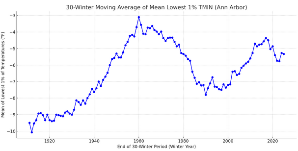
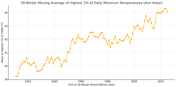
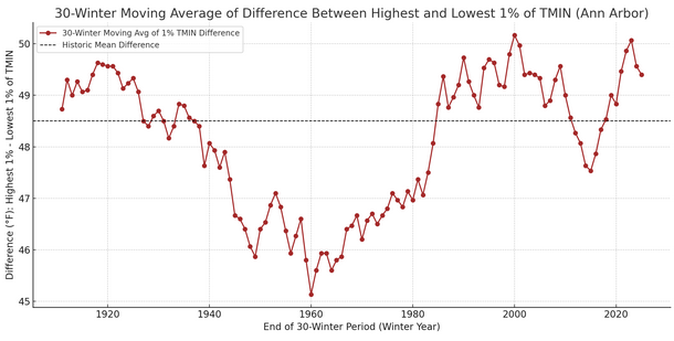
Although winters are warming in the Great Lakes Region, the initial point made earlier in this thread concerning the coldest temperatures is not unreasonable. I used the Ann Arbor (University of Michigan COOP) to illustrate the point given some of the commentary regarding the Detroit threaded record. Instead of taking the lowest temperature for each winter, I focused on the lowest 1% of temperatures for a somewhat broader perspective. I also included 30-winter moving averages for the lowest 1% of temperatures. These temperatures have been range-bound (ranging from -10.1° for winters winters 1882-83 through 1911-12 to -3.1° for winters 1930-31 through 1959-60). The most recent value is -5.3° for the 30-winter period ending with winter 2024-25. The historic value for the entire period of record is -6.8°. Below are charts for individual winter and 30-winter values (trend line is +0.3° per decade) and also a closer look at 30-winter values on a narrower temperature scale to show the variability in the 30-winter mean value. It should be noticed that the sharpest rise in the 30-year moving average occurred prior to 1960. The slower rise in extreme cold in the Great Lakes Region likely has to do with how marine heatwaves in the Atlantic and Pacific have increasingly focused the coldest air masses into the Plains/Great Lakes area rather than over a larger stretch of North America through their influence on synoptic patterns. If one looks at the warmest 1% of winter minimum temperatures, one has seen a steady rise since the 30-winter period ending in 1959-1960, unlike the roller-coaster with bottom 1% of low temperatures. What this means is that winter temperatures have grown more volatile allowing for a relatively stable bottom 1% of temperatures even as the top 1% of warmest low temperatures has continued to increase. Below are the 30-year mean difference between the highest and lowest 1% of minimum temperatures. It is uncertain whether this increased volatility is merely part of a transition in a warming climate (warmer highest 1% of lows but more stable coldest 1% of lows for a short period of time before the coldest 1% lows shift upward), or whether the increased volatility, which allows for continued shots of extreme cold, will become a "new normal" for perhaps several decades. For now, elevated volatility rules.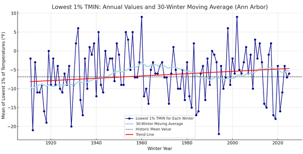
-
The facts show otherwise. Numerous locations in the greater NYC region are having a top 5 summer through July 17th: Bridgeport: 4th warmest Islip: 1st warmest JFK Airport: 2nd warmest Newark: 5th warmest Moreover, Islip, JFK Airport, and Newark have all reached 100° or above this summer. The only other summers that saw such readings at all three locations were 1966, 1999, 2010, and 2011.
-
July 2025 Discussion-OBS - seasonable summer variability
donsutherland1 replied to wdrag's topic in New York City Metro
Tomorrow will be partly cloudy and warm. Highs will reach the lower and middle 80s. A shower or thundershower is possible in the evening or overnight as a warm front crosses the region. Sunday will be steamy with highs in the middle and perhaps upper 80s. Additional showers and thunderstorms are possible Sunday evening into Monday morning as a cold front moves across the region. There is some severe weather and excessive rainfall potential. Behind the front, it will turn somewhat cooler and much less humid through the middle of next week. Monday through Wednesday should feature bright sunshine, low humidity, and pleasant temperatures mainly in the lower 80s. Low temperatures on Tuesday and Wednesday morning should be in the 60s in New York City. Some outlying areas could see lows fall into the upper 50s on Tuesday morning. No widespread and sustained excessive or record-challenging heat appears likely through the first three weeks of July. However, some of the guidance continues to show a brief surge of high heat late next week. The 12z ECMWF and EPS is particularly bullish with the potential heat. The ENSO Region 1+2 anomaly was +0.4°C and the Region 3.4 anomaly was 0.1°C for the week centered around July 9. For the past six weeks, the ENSO Region 1+2 anomaly has averaged +0.52°C and the ENSO Region 3.4 anomaly has averaged +0.07°C. Neutral ENSO conditions will likely continue through the summer. The SOI was +7.20 today. The preliminary Arctic Oscillation (AO) was -0.122 today. Based on sensitivity analysis applied to the latest guidance, there is an implied 72% probability that New York City will have a warmer than normal July (1991-2020 normal). July will likely finish with a mean temperature near 78.9° (1.4° above normal). -
I think there's nothing they can do at Central Park if the Conservatory refuses to trim the trees. Thus, since monthly and annual data can be adjusted as appropriate to compensate for the site changes that have affected high temperatures during the foliage season, the station goes on as is. I suspect that the value of a long-term climate record supersedes the loss of quality of day-to-day readings.
-
90° Days (January 1-July 17, 2025) and Ranking since 1970: Bridgeport: 10 days (Tied 1st) Islip: 8 days (Tied 5th) New York City-Central Park: 7 days (Tied 24th) New York City-JFK Airport: 10 days (Tied 3rd) New York City-LaGuardia Airport: 15 days (Tied 5th) Newark: 21 days (Tied 7th)
-
Perhaps even wilder, Bridgeport leads Central Park 10-7 in 90° days. Since 1948, Bridgeport has never had more 90° days than Central Park. There was only a single year with a tie at 8 days for each location (2006).
-
July 2025 Discussion-OBS - seasonable summer variability
donsutherland1 replied to wdrag's topic in New York City Metro
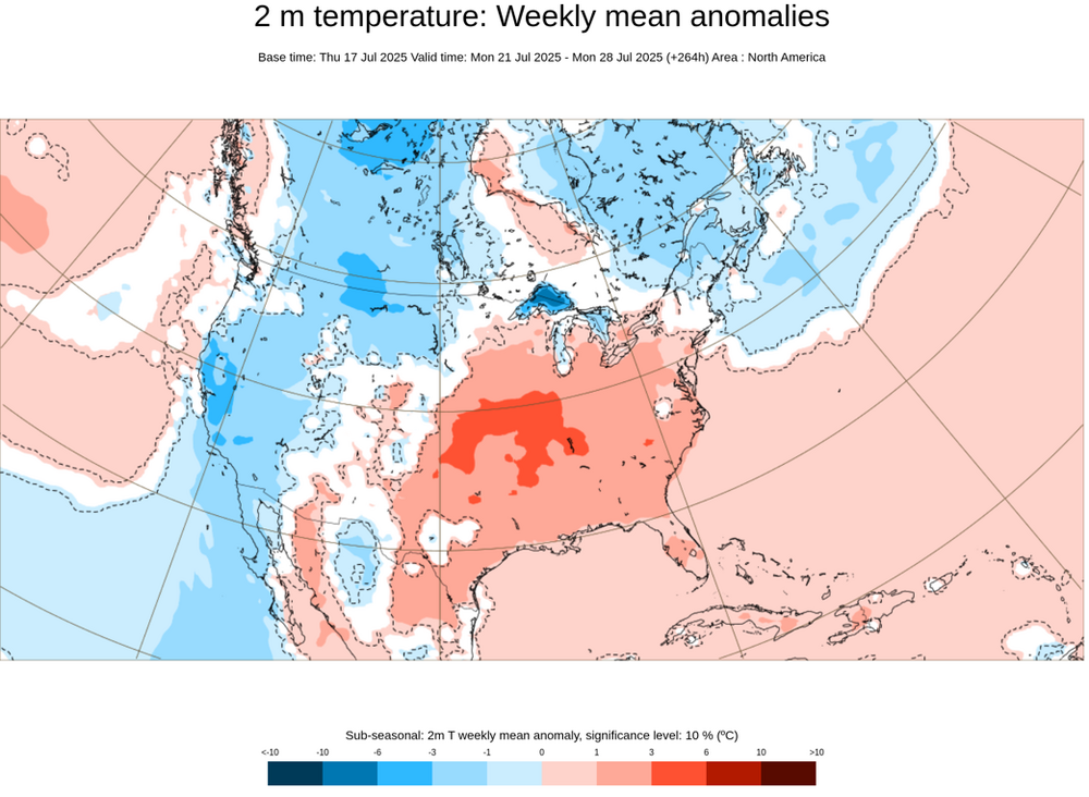
I suspect that the first week of August could turn cooler and less humid for at least a time, as a powerful heat dome retrogrades to the Rockies. But above normal temperatures will likely return during the second week of the month. However, as that's still far in the future, the guidance can yet change. -
2025-2026 ENSO
donsutherland1 replied to 40/70 Benchmark's topic in Weather Forecasting and Discussion
Yes, it's shifting westward. The heat will probably be more prolonged in the western half of the CONUS than the eastern half. -
2025-2026 ENSO
donsutherland1 replied to 40/70 Benchmark's topic in Weather Forecasting and Discussion
With some of the guidance hinting at the development of a 600 dm heat dome in the vicinity of the Rockies, there is already a strong heat signal showing up east of the Rockies. That area of heat will likely shift westward the following week. As the heat shifts westward, places like Denver could approach or reach 100° on one or more days. Parts of Kansas and Oklahoma could see numerous days with highs of 100° or above. Phoenix could see another stretch of 110°+ heat with a possible 115° high. The Northeast, especially New England, could turn cooler than normal for a time.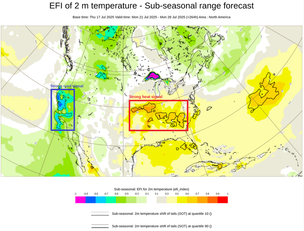
-
July 2025 Discussion-OBS - seasonable summer variability
donsutherland1 replied to wdrag's topic in New York City Metro
Yesterday saw some record high minimum temperatures in the New York City area: Bridgeport: 77° (tied record set in 1968) Islip: 79° (old record: 75°, 1969, 2010, 2013, and 2021) -
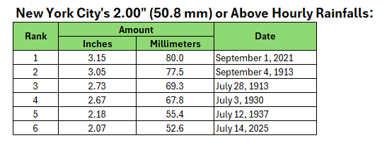
The second rainfall was due to a slow-moving Hurricane that made landfall in North Carolina.
-
July 2025 Discussion-OBS - seasonable summer variability
donsutherland1 replied to wdrag's topic in New York City Metro
I was informed that there are I.T. issues. They are being worked on. -
July 2025 Discussion-OBS - seasonable summer variability
donsutherland1 replied to wdrag's topic in New York City Metro
Today was the fifth day this year that Bridgeport, Islip, Central Park, JFK Airport, LaGuardia Airport, Newark, and White Plains all hit 90° or above. That is the most such occurrences in a year since 2022 when there were 7 such days. The record is 13 days in 2010. -
July 2025 Discussion-OBS - seasonable summer variability
donsutherland1 replied to wdrag's topic in New York City Metro
Central Park reached 90° this evening, so 2025 remains tied with 2006 and 2016 for the most days on which temperatures at Bridgeport, Islip, JFK Airport, LaGuardia Airport, and Newark reached 90° or above and Central Park did not. All such days have occurred since 2000.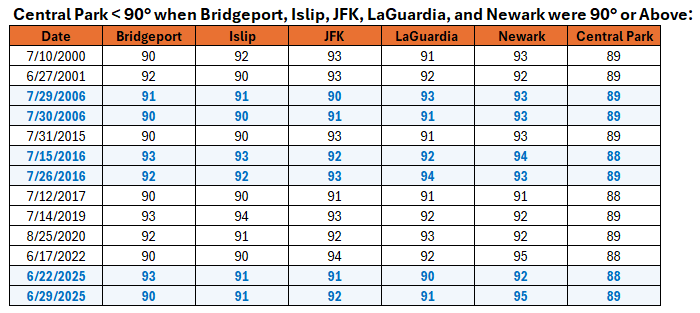
-
July 2025 Discussion-OBS - seasonable summer variability
donsutherland1 replied to wdrag's topic in New York City Metro
You’re welcome. There’s still a chance that it reaches or reached 90 between hours. We’ll know by around 8 pm. -
July 2025 Discussion-OBS - seasonable summer variability
donsutherland1 replied to wdrag's topic in New York City Metro
After clouds broke, it turned hot across the region. High temperatures included: Bridgeport: 90° Islip: 90° New York City-Central Park: 89° New York City-JFK Airport: 92° New York City-LaGuardia Airport: 93° Newark: 95° If today's high of 89° hold at Central Park, today would become the third day this year where all of the above locations except for Central Park reached 90°. That would break the record of two such days that was set in 2006 and tied in 2016. Tomorrow will be somewhat cooler and a warm and mainly dry weekend will follow. Additional showers and thunderstorms are possible Sunday evening into Monday morning as a front moves across the region. There is some severe weather and excessive rainfall potential. Behind the front, it will turn somewhat cooler on Monday. Tuesday and Wednesday should feature bright sunshine, low humidity, and pleasant temperatures mainly in the lower 80s. No widespread and sustained excessive or record-challenging heat appears likely through the first three weeks of July. However, some of the guidance shows a brief surge of high heat late next week. The ENSO Region 1+2 anomaly was +0.4°C and the Region 3.4 anomaly was 0.1°C for the week centered around July 9. For the past six weeks, the ENSO Region 1+2 anomaly has averaged +0.52°C and the ENSO Region 3.4 anomaly has averaged +0.07°C. Neutral ENSO conditions will likely continue through the summer. The SOI was +5.48 today. The preliminary Arctic Oscillation (AO) was -0.111 today. Based on sensitivity analysis applied to the latest guidance, there is an implied 74% probability that New York City will have a warmer than normal July (1991-2020 normal). July will likely finish with a mean temperature near 79.0° (1.5° above normal). -
July 2025 Discussion-OBS - seasonable summer variability
donsutherland1 replied to wdrag's topic in New York City Metro
94° at Newark, 91° at JFK, and 90° at LGA. -
It's 6th if one goes back before 1943. I'm not sure why all of the hourly NCEI data hasn't been incorporated into the digital database.
-
The July 14 reading was revised up to 16.86°C. The preliminary July 15 temperature was 16.86°C (second warmest for the date on the ERA5 dataset).
-
July 2025 Discussion-OBS - seasonable summer variability
donsutherland1 replied to wdrag's topic in New York City Metro
Even as the New York City region continues to suffer in a steam bath, Bismarck saw the temperature fall to 40° this morning. That broke the daily record of 42° from 1984. It is also the coldest July reading there since July 27, 2013 when the mercury dipped to 39°. Next week could see a brief push of cooler air that could send the mercury into the middle or upper 60s in New York City coupled with low humidity and refreshing daytime temperatures. In 2013, a cool stretch followed Bismarck's low of July 27 a few days later. Unlike 2013 when there were reinforcing cool shots, that does not yet appear to be the case for this year.


