donsutherland1
-
Posts
23,988 -
Joined
Content Type
Profiles
Blogs
Forums
American Weather
Media Demo
Store
Gallery
Everything posted by donsutherland1
-
2025-2026 ENSO
donsutherland1 replied to 40/70 Benchmark's topic in Weather Forecasting and Discussion
My snowfall contingency tables for DCA, PHL, and NYC are AO-PNA tables. -
I hope the Giants will have a better year this upcoming season.
-
Mountain West Discussion
donsutherland1 replied to mayjawintastawm's topic in Central/Western States
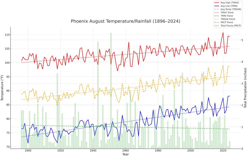
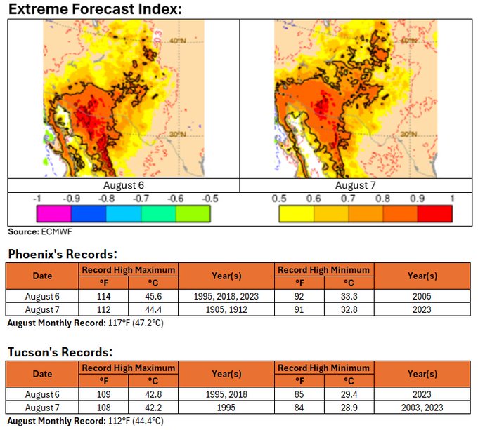
A period of extreme heat will affect Phoenix and Tucson this week, peaking on Wednesday and Thursday. Daily record highs will fall and the August monthly records will be challenged. The long-term August trend for Phoenix is hotter and drier.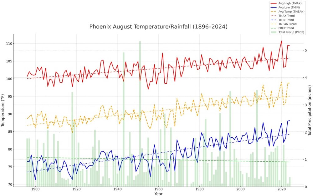
-
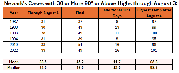
2025 is the 7th year during which Newark had 30 or more 90° or above highs by August 4th. Today was its 31st such day. Here's how things evolved during the prior six years:
-
Newark hit 90° for the 31st time this year. That is tied with 1987 and 1994 for the fourth highest figure on record through August 4. Tomorrow will be another very warm day with highs in the middle and upper 80s across the region. A cold front will cross the region afterward. The frontal passage will likely be dry for most of the region. The remainder of the week will see temperatures average somewhat below normal. A new round of heat could develop around or just after August 10th. Parts of the region could see a return of 90° or above heat. Extreme heat still appears unlikely. The ENSO Region 1+2 anomaly was +0.4°C and the Region 3.4 anomaly was -0.3°C for the week centered around July 30. For the past six weeks, the ENSO Region 1+2 anomaly has averaged +0.37°C and the ENSO Region 3.4 anomaly has averaged -0.08°C. Neutral ENSO conditions will likely continue through the summer. The SOI was -19.66 today. The preliminary Arctic Oscillation (AO) was +0.253 today.
-
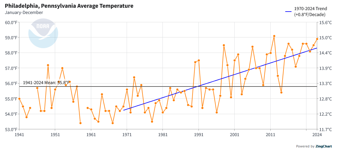
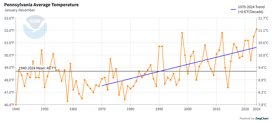
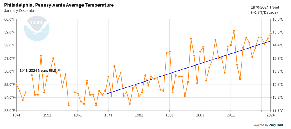
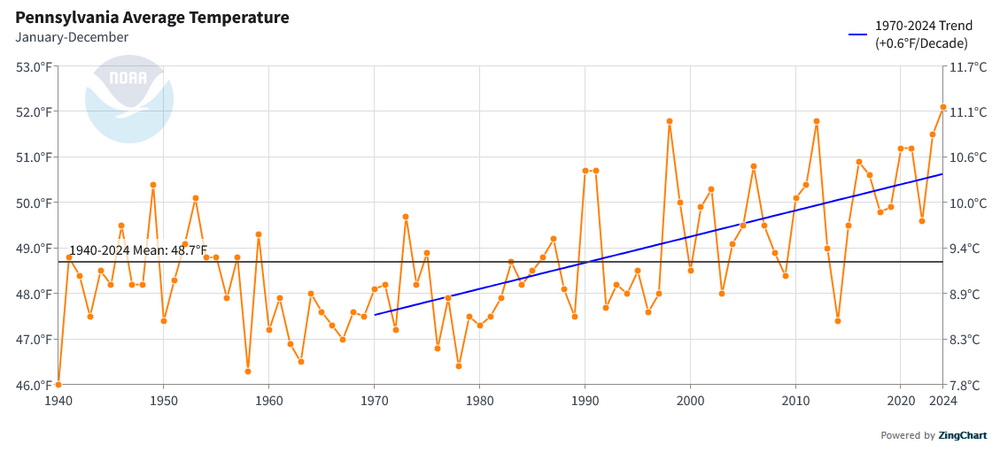
Since 1970, (at least through 2010), Philadelphia's heat island has been fairly stable. Here's a paper: https://www.fs.usda.gov/nrs/pubs/jrnl/2023/nrs_2023_locke_001.pdf Most of Philadelphia's warming has been due to climate change. Philadelphia has warmed about 0.8° per decade vs. 0.6° per decade for all of Pennsylvania since 1970.
-
It should be noted that the July 1980 mean monthly temperature of 92.0° at Dallas-Fort Worth has been exceeded by two months. August 2011 (93.4°) and August 2023 (92.9°) were hotter.
-
Not until at least my son finishes college (he's only starting high school this fall).
-
90s are possible. I don’t think it will rival the late June and also peak July heat. The Atlantic might see 1-2 tropical cyclones, but the forecast pattern isn’t one that favors landfalls. A lot can still change given the lead time.
-
It will turn briefly noticeably warmer for tomorrow and Tuesday before another somewhat cooler air mass arrives. Durng tomorrow, smoke could dim the sun at times and lead to air quality issues, especially north of New York City. The frontal passage will likely be dry for most of the region. The remainder of the week will see temperatures average somewhat below normal. A new round of heat could develop around or just after August 10th. Parts of the region could see a return of 90° or above heat. Extreme heat still appears unlikely. The ENSO Region 1+2 anomaly was +0.6°C and the Region 3.4 anomaly was -0.2°C for the week centered around July 23. For the past six weeks, the ENSO Region 1+2 anomaly has averaged +0.48°C and the ENSO Region 3.4 anomaly has averaged 0.00°C. Neutral ENSO conditions will likely continue through the summer. The SOI was -19.60 today. The preliminary Arctic Oscillation (AO) was +0.307 today.
-
Thanks. No, I don't have a boat. Perhaps when I retire, I'll get one.
-
Still deep blue skies in southern Westchester County. That will likely change this afternoon.
-
Didn’t feel it in southern Westchester. https://earthquake.usgs.gov/earthquakes/eventpage/us6000qxsb/executive
-
A break in the heat is now underway. The day started with another round of unseasonably cool readings. Low temperatures included: Bridgeport: 62° Danbury: 55° Farmingdale: 60° Islip: 60° New Haven: 61° New York City-Central Park: 63° New York City-JFK Airport: 62° New York City-LaGuardia Airport: 65° Newark: 62° Philadelphia: 64° Poughkeepsie: 52° White Plains: 58° Generally somewhat cooler than normal conditions will likely persist through the first week of August. It could briefly turn warmer for Monday and Tuesday before another somewhat cooler air mass arrives. The frontal passage will likely be dry for most of the region. There remain hints on the long-range guidance that a new round of heat could develop around August 10th. Parts of the region could see a return of 90° or above heat. The ENSO Region 1+2 anomaly was +0.6°C and the Region 3.4 anomaly was -0.2°C for the week centered around July 23. For the past six weeks, the ENSO Region 1+2 anomaly has averaged +0.48°C and the ENSO Region 3.4 anomaly has averaged 0.00°C. Neutral ENSO conditions will likely continue through the summer. The SOI was -8.01 today. The preliminary Arctic Oscillation (AO) was +0.017 today.
-
2025-2026 ENSO
donsutherland1 replied to 40/70 Benchmark's topic in Weather Forecasting and Discussion
The CANSIPS (cool) and CFSv2 (warm) are at odds regarding the fall outcome in the central U.S. It will be interesting to see what the ECMWF seasonal forecast shows when it comes out in a few days. -
A break in the heat is now underway. This morning featured refreshingly cool temperatures. Central Park saw a low of 63°, which was its coolest low temperature since June 28 when the low was also 63°. Low temperatures included: Bridgeport: 62° Danbury: 61° Farmingdale: 63° Islip: 65° New Haven: 63° New York City-Central Park: 63° New York City-JFK Airport: 65° New York City-LaGuardia Airport: 64° Newark: 63° Philadelphia: 66° Poughkeepsie: 59° White Plains: 61° Generally somewhat cooler than normal conditions will likely persist through the first week of August. It could briefly turn warmer around the middle of next week. There remain hints on the long-range guidance that a new round of heat could develop past August 10th. The ENSO Region 1+2 anomaly was +0.6°C and the Region 3.4 anomaly was -0.2°C for the week centered around July 23. For the past six weeks, the ENSO Region 1+2 anomaly has averaged +0.48°C and the ENSO Region 3.4 anomaly has averaged 0.00°C. Neutral ENSO conditions will likely continue through the summer. The SOI was +3.58 today. The preliminary Arctic Oscillation (AO) was -0.359 today.
-
Yesterday, Bridgeport recorded 0.20" of rain, while Islip measured 2.93". This marks the lowest rainfall on record at Bridgeport on a day when Islip received 2.50" or more. The previous record was set on August 19, 1990, when Islip recorded 3.83" and Bridgeport received 0.39".
-
July 2025 Discussion-OBS - seasonable summer variability
donsutherland1 replied to wdrag's topic in New York City Metro
July 2025 ranked among the 10 hottest Julys on record in the greater New York City area: Monthly Mean Temperatures: Bridgeport: 78.2° (5th hottest) Islip: 78.5° (2nd hottest) New York City-Central Park: 79.5° (tied 14th hottest) New York City-JFK Airport: 79.9° (2nd hottest) New York City-LaGuardia Airport: 81.0° (8th hottest) Newark: 82.1° (5th hottest) Notes: The 0.4° difference between JFK Airport and Central Park when JFK Airport had a higher mean temperature in July was the largest such difference on record. Adjusting for the trees would have led to a mean temperature near 80.0° in Central Park. That would have tied for 8th hottest.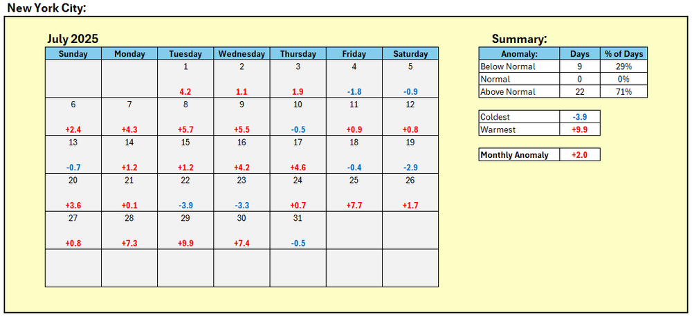
-
Select Rainfall Reports: Browns Mills, NJ: 6.00" 2 WNW Manchester TWP, NJ: 4.78" Boothwyn, PA: 4.05"
-
Yes. There were hourly amounts of 5.34” and 4.37”. They occurred in back-to-back hourly periods.
-
E PA/NJ/DE Summer 2025 Obs/Discussion
donsutherland1 replied to Hurricane Agnes's topic in Philadelphia Region
Atlantic City picked up 2.29" (58.2 mm) of rain in the past hour. Today's rainfall has reached 3.03" (77.0 mm). That demolishes the daily record for July 31 of 0.85" (21.6 mm) from 2009. -
Yes. August 13, 2014. Islip had 13.51" of rain. Bridgeport had 1.66", Central Park had 0.53", JFK Airport had 2.92"; LaGuardia Airport had 0.78", and Newark had 0.34".
-
July 2025 Discussion-OBS - seasonable summer variability
donsutherland1 replied to wdrag's topic in New York City Metro
Only once at Central Park: July 1993 with 20 days. JFK’s record is 13 days from July 2010. -
As an example of how convective rainfall can drench areas while others see little rainfall, July 28, 2012 saw 2.98” fall at Islip and just 0.07” at JFK Airport.