donsutherland1
-
Posts
23,988 -
Joined
Content Type
Profiles
Blogs
Forums
American Weather
Media Demo
Store
Gallery
Everything posted by donsutherland1
-
July 2025 Discussion-OBS - seasonable summer variability
donsutherland1 replied to wdrag's topic in New York City Metro
Some of the remnant showers from last night's thunderstorms in Pennsylvania have now moved into southern Westchester County. -
What are the trends for the last 30 years?
-
July 2025 Discussion-OBS - seasonable summer variability
donsutherland1 replied to wdrag's topic in New York City Metro
Parts of the region will experience a shower or thundershower this evening and tonight. The heat will peak tomorrow with highs topping out in the lower 90s across much of the region. Friday will be somewhat cooler and a warm and mainly dry weekend will follow. Additional showers and thunderstorms are possible Sunday evening into Monday morning. There is some severe weather and excessive rainfall potential. No widespread and sustained excessive or record-challenging heat appears likely through the first three weeks of July. The ENSO Region 1+2 anomaly was +0.4°C and the Region 3.4 anomaly was 0.1°C for the week centered around July 9. For the past six weeks, the ENSO Region 1+2 anomaly has averaged +0.52°C and the ENSO Region 3.4 anomaly has averaged +0.07°C. Neutral ENSO conditions will likely continue through the summer. The SOI was +11.33 today. The preliminary Arctic Oscillation (AO) was +0.121 today. Based on sensitivity analysis applied to the latest guidance, there is an implied 74% probability that New York City will have a warmer than normal July (1991-2020 normal). July will likely finish with a mean temperature near 79.0° (1.5° above normal). -
Thanks. That's still subsequent to your starting point. So, it appears that one is, in fact, dealing with a changing sample mix, which makes it tougher to discern the actual trend.
-
Doesn't Atglen only go back to 2019? If your sample mix is changing over time, how do you know what seems to be a trend isn't, in fact, an artifact of the changing sample?
-
There is a paper that now explains the synoptic events that drove the record heat, including Phoenix's record 31 consecutive days of 110° or above heat, in the Southwest (U.S. and Mexico) during 2023. In short, the combination of an abnormally warm Atlantic Ocean (dominant factor) and rising El Niño created a semi-permanent heat ridge. The paper explained: It was found that a large-scale, semi-persistent atmospheric blocking pattern was anchored over the region for most of the summer, a feature that enhanced incoming solar radiation, thermal heating, and sensible heating, deep subsidence, while reducing precipitation, thus increasing surface temperatures. The atypical features of this extreme event suggested that there were slow-varying large-scale forcings at play, potentially promoting its occurrence. It was shown that the homogeneous interbasin warm SSTs from the record warm Atlantic Ocean and a growing El Niño event in the Pacific modulated large-scale atmospheric circulation. These circulation changes thus promoted a semi-permanent anticyclonic blocking pattern, significantly increasing surface heating, which led to the growth and persistence of the heatwave. The paper can be found here: https://www.nature.com/articles/s41467-025-61859-y
-
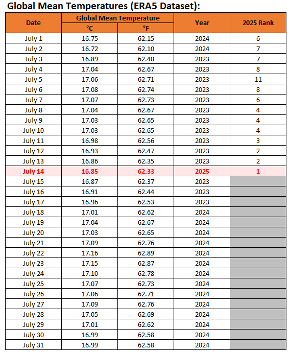
Overall, July 1-14, 2025 ranks 4th warmest. I suspect that July 2025 will finish third.
-
With the preliminary value for July 14th now in, July 2025 has now seen its first record warm global mean temperature of July. That this follows a La Niña winter and coincides with persistent neutral ENSO conditions is quite remarkable.
-
Is that for stations that haven't changed e.g., location, etc.?
-
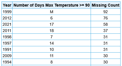
There are too many missing summer days in a number of recent years, some of which had large numbers of 90° or above days in the region.
-
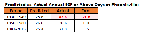
Last year, a similar issue arose regarding 95° or above days at Phoenixville. It's pre-1950 data is unreliable. For the 95° or above highs, I ran regression equations based on the 1950-1980 period testing West Chester and Phoenixville and West Chester and Coatesville. The West Chester - Phoenixville equation broke down badly when applied to the 1930-1949 period, ballooning from 2.8 days to 12.4 days. The West Chester - Coatesville equation held reasonably consistent. This disparity suggested that the issue concerned Phoenixville, not West Chester. To determine whether the 1950-1980 period was an issue, I also tested that equation for 1981-2015 for West Chester - Phoenixville. The equation held up reasonably well. The Coatesville data record ended in 1982, so I could not test the West Chester - Coatesville relationship. The equations for the 1930-1949 and 1950-80 periods strongly argued that Phoenixville's 1930-1949 measurements were at issue and are not reliable. That also includes the currently recognized state maximum temperature record of 111° that was set at Phoenixville. The more likely value is probably near 105° based on the 1950-1980 relationship. I now repeated the exercise for 90° or above highs at Phoenixville. I expected that just as had been the case with 95° or above highs, the 1930-1949 period would see vastly more 90° or above highs than predicted while the 1981-2015 period would not be too different from what was predicted. The outcome: The 1930-1949 Phoenixville data is wildly out of line with both the rest of its historical record and the West Chester data that it is unusable in its raw form for any credible analyses.

-
July 2025 Discussion-OBS - seasonable summer variability
donsutherland1 replied to wdrag's topic in New York City Metro
Following yesterday's deluge, today was a much drier day. Some showers or thundershowers could return to the region tomorrow afternoon and tomorrow night. It will turn somewhat warmer tomorrow with temperatures rising through into the middle and upper 80s. The heat will likely peak on Thursday with highs topping out in the upper 80s and perhaps lower 90s. A warm and mainly dry weekend will follow. No widespread and sustained excessive or record-challenging heat appears likely through the first three weeks of July. The ENSO Region 1+2 anomaly was +0.4°C and the Region 3.4 anomaly was 0.1°C for the week centered around July 9. For the past six weeks, the ENSO Region 1+2 anomaly has averaged +0.52°C and the ENSO Region 3.4 anomaly has averaged +0.07°C. Neutral ENSO conditions will likely continue through the summer. The SOI was +2.09 today. The preliminary Arctic Oscillation (AO) was +0.295 today. Based on sensitivity analysis applied to the latest guidance, there is an implied 71% probability that New York City will have a warmer than normal July (1991-2020 normal). July will likely finish with a mean temperature near 79.0° (1.5° above normal). -
Yes, I'm aware of that. That's why I noted the difference between the PNS (2.95") and the climate record entry (3.38").
-
Occasional Thoughts on Climate Change
donsutherland1 replied to donsutherland1's topic in Climate Change
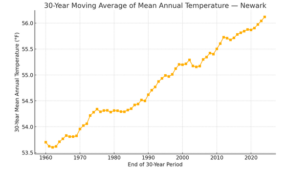
For illustrative purposes, I ran the numbers for Newark to examine the connection between temperature and extreme rainfall events. I used mean top 1% of rainfall for 30-year periods and 30-year moving temperatures. Again, as had been the case with New York City, there's a strong connection between temperature and extreme precipitation events (coefficient of determination: 0.91). In short, a warming climate is increasing the intensity of extreme precipitation events.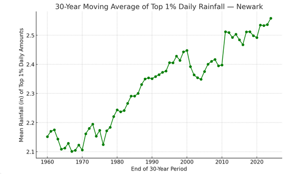
-
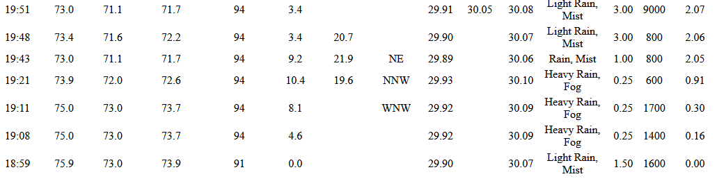
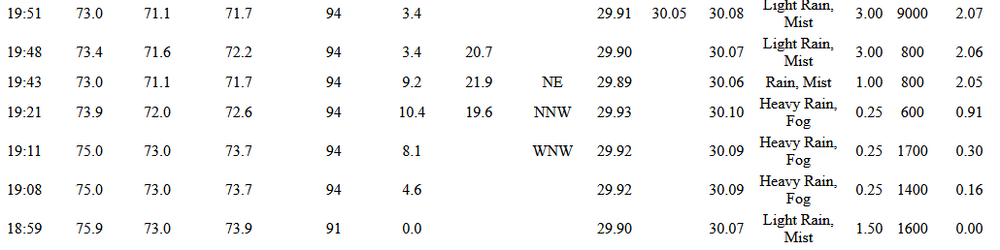
The intensity of the precipitation e.g., "light rain" is only at the point of observation e.g., 19:51. Here's a more complete record during the heavy rainfall:
-
I agree. Hopefully, there will be an update this morning.
-
010 NOUS41 KOKX 150711 RRA PNSOKX CTZ005>012-NJZ002-004-006-103>108-NYZ067>075-078>081-176>179-151900- Public Information Statement...Corrected National Weather Service New York NY 311 AM EDT Tue Jul 15 2025 ...PRECIPITATION REPORTS... Location Amount Time/Date Provider ...Connecticut... ...Fairfield County... Greenwich 3.19 in 0155 AM 07/15 CWOP Danbury 3.07 in 0159 AM 07/15 CWOP Danbury 2.43 in 0145 AM 07/15 CWOP Danbury 2.03 in 0200 AM 07/15 CWOP Danbury 1.99 in 0159 AM 07/15 CWOP 1 WNW Redding 1.90 in 0150 AM 07/15 AWS REDDING 1.81 in 0158 AM 07/15 CWOP Danbury Airport 1.80 in 0153 AM 07/15 ASOS Redding 1.69 in 0155 AM 07/15 CWOP Greenwich 1.45 in 0155 AM 07/15 AWS Ridgefield 1.44 in 0153 AM 07/15 AWS 3 N New Canaan 1.39 in 0154 AM 07/15 AWS Redding Ridge 1.35 in 0200 AM 07/15 CWOP 2 E Greenwich 1.23 in 0155 AM 07/15 AWS STAMFORD 1.16 in 1055 PM 07/14 CWOP ...New Haven County... Wolcott 1.34 in 0155 AM 07/15 AWS Oxford 1.18 in 0153 AM 07/15 CWOP ...New Jersey... ...Bergen County... 1 SSE Franklin Lakes 3.73 in 0145 AM 07/15 IFLOWS Leonia 2.79 in 0155 AM 07/15 AWS Tenafly 2.54 in 0155 AM 07/15 CWOP Tenafly 2.42 in 0155 AM 07/15 AWS Tenafly 2.33 in 0156 AM 07/15 CWOP New Milford 2.26 in 0150 AM 07/15 AWS Teterboro Airport 2.25 in 0151 AM 07/15 ASOS Hasbrouck Heights 2.22 in 0154 AM 07/15 CWOP Mahwah 2.04 in 0155 AM 07/15 AWS Ridgwood 1.86 in 0158 AM 07/15 CWOP Bergenfield 1.81 in 0145 AM 07/15 CWOP Oakland 1.79 in 0200 AM 07/15 CWOP Emerson 1.43 in 0146 AM 07/15 CWOP Oakland 1.27 in 0155 AM 07/15 AWS Paramus 1.15 in 0155 AM 07/15 AWS North Arlington 1.11 in 0155 AM 07/15 AWS ...Essex County... 1.6 W Millburn 3.00 in 0145 AM 07/15 HADS Millburn 2.62 in 0155 AM 07/15 AWS Maplewood 2.54 in 0110 AM 07/15 IFLOWS West Orange 2.19 in 0155 AM 07/15 CWOP 1 W Newark 2.05 in 0150 AM 07/15 AWS WEST CALDWELL 1.94 in 0155 AM 07/15 CWOP 1 W Orange 1.75 in 0155 AM 07/15 URBANET West Caldwell 1.72 in 0154 AM 07/15 AWS Caldwell 1.59 in 0153 AM 07/15 ASOS Fairfield 1.49 in 0155 AM 07/15 AWS West Caldwell 1.41 in 0200 AM 07/15 CWOP 0.6 SW Caldwell 1.36 in 0145 AM 07/15 IFLOWS Newark 1.17 in 0155 AM 07/15 AWS 2 S Kearny 1.01 in 0153 AM 07/15 AWS ...Hudson County... 1 W Hoboken 1.28 in 0155 AM 07/15 AWS Kearny 1.12 in 0156 AM 07/15 CWOP Hoboken 1.03 in 0157 AM 07/15 CWOP ...Passaic County... 0.8 SE Pompton Lakes 2.59 in 0130 AM 07/15 HADS Ringwood 2.56 in 0110 AM 07/15 RAWS Wayne 2.51 in 0145 AM 07/15 CWOP 2.1 E Ringwood 2.28 in 0145 AM 07/15 IFLOWS WAYNE 2.27 in 0155 AM 07/15 CWOP North Haledon 2.06 in 0200 AM 07/15 CWOP 1.5 SW Ringwood 1.56 in 0145 AM 07/15 IFLOWS 1 NNE North Caldwell 1.36 in 0153 AM 07/15 AWS Hawthorne 1.20 in 0200 AM 07/15 CWOP West Milford 1.18 in 0159 AM 07/15 CWOP ...Union County... Mountainside 5.34 in 0130 AM 07/15 IFLOWS Linden Airport 4.38 in 0155 AM 07/15 AWOS Bayside 4.10 in 0159 AM 07/15 CWOP Newark Airport 2.13 in 0151 AM 07/15 ASOS ...New York... ...Bronx County... 1 NE Harlem 2.64 in 0155 AM 07/15 AWS ...Nassau County... Great Neck 1.18 in 0200 AM 07/15 CWOP ...New York (Manhattan) County... Central Park 2.64 in 0151 AM 07/15 ASOS Washington Heights 2.08 in 0150 AM 07/15 AWS Midtown Manhattan 1.88 in 0150 AM 07/15 AWS New York 1.85 in 0200 AM 07/15 CWOP NEW YORK 1.52 in 0145 AM 07/15 CWOP ...Orange County... 2.6 NW Tuxedo Park 3.92 in 0145 AM 07/15 HADS Newburgh 3.06 in 0136 AM 07/15 CWOP CORNWALL ON HUDSON 2.53 in 0200 AM 07/15 CWOP Tuxedo Park 2.35 in 0155 AM 07/15 AWS Washingtonville 2.13 in 0200 AM 07/15 CWOP US Military Academy 1.93 in 1255 AM 07/15 RAWS Vails Gate 1.65 in 0156 AM 07/15 CWOP NEW WINDSOR 1.27 in 0200 AM 07/15 CWOP West Point 1.21 in 0153 AM 07/15 AWS Harriman 1.15 in 0155 AM 07/15 AWS Chester 1.11 in 0155 AM 07/15 CWOP Chester 1.03 in 0150 AM 07/15 AWS ...Putnam County... Lake Carmel 3.23 in 0156 AM 07/15 CWOP Mahopac 1.03 in 0155 AM 07/15 AWS ...Queens County... NYC/La Guardia 1.66 in 0151 AM 07/15 ASOS Bellerose 1.52 in 0151 AM 07/15 CWOP OZONE PARK 1.38 in 0159 AM 07/15 CWOP LONG ISLAND CITY 1.23 in 0159 AM 07/15 CWOP NYC/JFK Airport 1.02 in 0151 AM 07/15 ASOS ...Richmond County... Eltingville 2.14 in 0200 AM 07/15 CWOP Staten Island 1.43 in 0146 AM 07/15 CWOP ...Rockland County... Nanuet 5.03 in 0130 AM 07/15 IFLOWS 1 SSW Mount Ivy 4.12 in 0154 AM 07/15 AWS 1 NW Haverstraw 3.10 in 0153 AM 07/15 AWS Montebello 2.76 in 0200 AM 07/15 CWOP 0.9 N Montebello 2.36 in 0130 AM 07/15 HADS New City 2.29 in 0153 AM 07/15 AWS Stony Point 2.22 in 0153 AM 07/15 AWS Spring Valley 1.39 in 0145 AM 07/15 CWOP Sloatsburg 1.01 in 0200 AM 07/15 CWOP ...Suffolk County... Fort Salonga 1.55 in 0153 AM 07/15 AWS Old Field 1.47 in 0155 AM 07/15 AWS East Setauket 1.23 in 0158 AM 07/15 CWOP Northport 1.22 in 0200 AM 07/15 CWOP COMMACK 1.16 in 0155 AM 07/15 CWOP ...Westchester County... Tarrytown 4.06 in 0147 AM 07/15 CWOP Dobbs Ferry 3.38 in 0155 AM 07/15 AWS Midland Park 3.36 in 0145 AM 07/15 IFLOWS 1 SSE Hartsdale 3.23 in 0155 AM 07/15 AWS Armonk 2.97 in 0145 AM 07/15 CWOP White Plains Airport 2.95 in 0156 AM 07/15 ASOS Rye Brook 2.79 in 0154 AM 07/15 AWS SCARSDALE 2.25 in 0145 AM 07/15 CWOP 1 NW Rye 1.89 in 0153 AM 07/15 AWS 1 S Peach Lake 1.83 in 0155 AM 07/15 AWS PORT CHESTER 1.71 in 0158 AM 07/15 CWOP Pleasantville 1.61 in 0155 AM 07/15 AWS Ossining 1.38 in 0159 AM 07/15 CWOP New Rochelle 1.22 in 0145 AM 07/15 CWOP Rye 1.21 in 0155 AM 07/15 AWS ...Maritime Stations... Greenwich 1.32 in 0157 AM 07/15 CWOP &&
-
Yesterday, White Plains picked up 3.38" of rain. That smashed the daily record of 1.63" from 2014. That was also the second highest amount for any day in July. The highest amount for any day in July was 3.44" from July 18, 2022. It was also White Plains' 7th highest summer (June-August) daily rainfall on record. It was White Plains' biggest rainfall since September 29, 2023 when 4.10" fell. New York City (Central Park), Newark, and White Plains all received 2.00" or more daily rainfall for the first time since March 23, 2024. The last time all three stations saw 2" or more daily rainfall during the summer was August 22, 2021. NOTE: The PNS shows 2.95" at White Plains. The climate record in XmAcis shows 3.38".
-
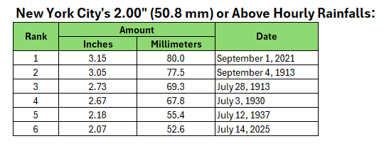
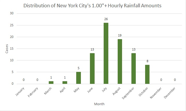
New York City's 2" or Above Hourly Rainfalls:
-
New York City received 2.07" (52.6 mm) of rain in the past hour. That is the 4th biggest hourly rainfall on record for July. Moreover, it is the biggest hourly rainfall since an all-time record 3.15" (80.0 mm) of rain fell on September 1, 2021.
-
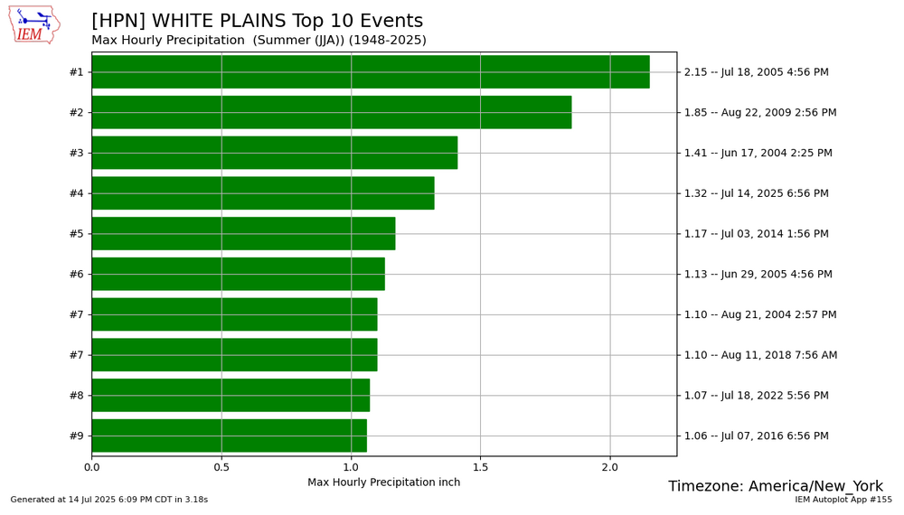
White Plains picked up 1.32" in the past hour. That's the second highest hourly mark on record for July and fourth highest for summer.
-
I was going to drive through there for an appointment in White Plains, but canceled the appointment based on the radar.
-
Valhalla and North White Plains are reporting flash flooding.
-
Newark has now gone over 1" of rain for the day. The daily mark is 1.90" from 1920. On that day, Central Park picked up just 0.15" of rain. I expect more rain there this time around. Scranton and Harrisburg have now set daily records for July 14.
-
July 2025 Discussion-OBS - seasonable summer variability
donsutherland1 replied to wdrag's topic in New York City Metro
Showers and heavy thunderstorms will affect parts of the region into early tomorrow morning. North and west of New York City will likely see a general 1"-3" of rain with locally higher amounts exceeding 4". Already, Scranton has picked up 2.32" of rain through 4:41 pm today. That breaks the daily record of 1.69" from 2017. That is also the 20th highest daily rainfall for any day in July. Heavy rain was also falling at Newark with 0.43" over the past 41 minutes. It will turn somewhat warmer tomorrow with temperatures rising through Thursday or Friday. The heat will likely peak on Thursday and Friday with highs topping out in the upper 80s and perhaps lower 90s. A warm and mainly dry weekend will follow. No widespread and sustained excessive or record-challenging heat appears likely through the first three weeks of July. The ENSO Region 1+2 anomaly was +0.4°C and the Region 3.4 anomaly was 0.1°C for the week centered around July 9. For the past six weeks, the ENSO Region 1+2 anomaly has averaged +0.52°C and the ENSO Region 3.4 anomaly has averaged +0.07°C. Neutral ENSO conditions will likely continue through the summer. The SOI was +1.05 today. The preliminary Arctic Oscillation (AO) was +0.077 today. Based on sensitivity analysis applied to the latest guidance, there is an implied 74% probability that New York City will have a warmer than normal July (1991-2020 normal). July will likely finish with a mean temperature near 79.2° (1.7° above normal).