donsutherland1
-
Posts
23,988 -
Joined
Content Type
Profiles
Blogs
Forums
American Weather
Media Demo
Store
Gallery
Everything posted by donsutherland1
-
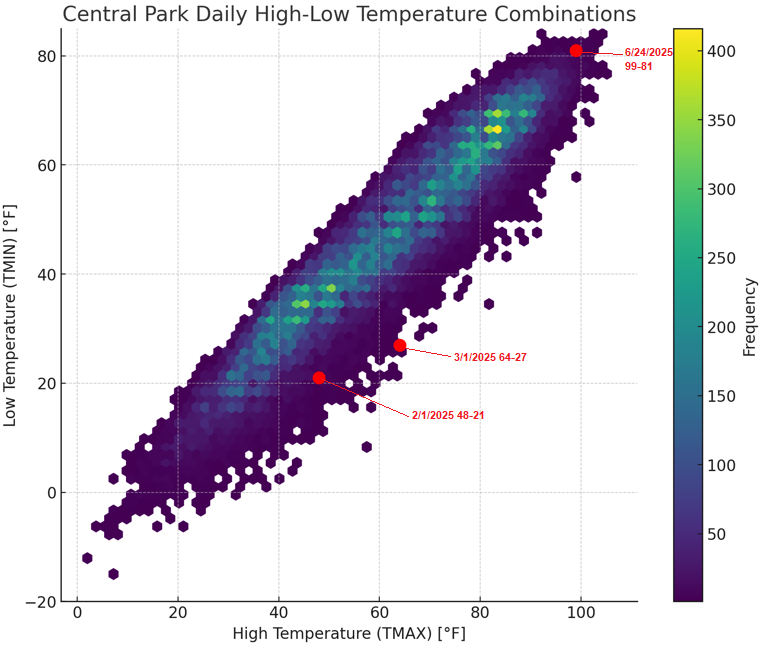
It’s a density plot based on the frequency of high-low temperatures based on the chart @TheClimateChangerposted. I highlighted this year’s first recorded high-low combinations.
-
The June 24, 2025 weathergami was actually the third this year: Islip, JFK Airport, LaGuardia Airport, and Newark also had weathergamis on June 24th. JFK Airport and Newark also had weathergamis on June 25th. The last time Central Park had two consecutive days with weathergamis was July 22-23, 2011. Its most consecutive is 3 which occurred during the extreme cold shot of December 29-31, 1917.
-
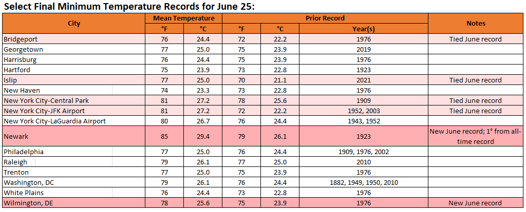
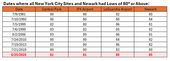
The recent historic June heatwave was also the first time June had seen Central Park, JFK Airport, LaGuardia Airport, and Newark register 80° or above minimum temperatures on the same date.
-
Yesterday, New York City (Central Park) had a low of 62° while White Plains had a low of 63°. That was the first time since May 28th that New York City had a lower minimum temperature than White Plains and just the fourth time this year that has happened.
-
That would fit the historic and 1991-2020 climate data. The ECMWF weeklies are also quite warm.
-
JFK Airport and Newark saw their lowest high temperatures two days after an 80° or above low. JFK Airport: 72° (old record: 76°, July 23, 2019) Newark: 72° (old record: 76°, July 23, 2019) Temperatures will return to the lower 80s for tomorrow and then middle and perhaps upper 80s for the remainder of June. Newark could be near or just above 90° on several days. In addition, there will be a risk of a shower or thundershower during the weekend. Excessive heat does not appear likely to return through at least the first week of July. The ENSO Region 1+2 anomaly was +1.0°C and the Region 3.4 anomaly was 0.2°C for the week centered around June 18. For the past six weeks, the ENSO Region 1+2 anomaly has averaged +0.47°C and the ENSO Region 3.4 anomaly has averaged -0.03°C. Neutral ENSO conditions will likely continue through at least late summer. The SOI was +12.65 yesterday. The preliminary Arctic Oscillation (AO) was +1.013 today. Based on sensitivity analysis applied to the latest guidance, there is an implied 99% probability that New York City will have a warmer than normal June (1991-2020 normal). June will likely finish with a mean temperature near 73.2° (1.2° above normal).
-
You can find it here.
-
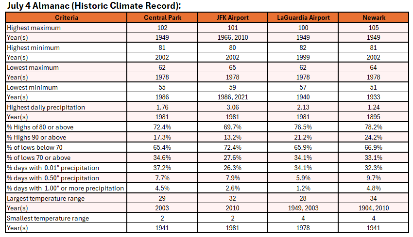
The hottest July 4 cases tended to occur during hotter summers, overall. Summer (June 1-August 31) Mean Temperatures for Central Park: 10 Hottest July 4 Cases: 75.3° 10 Coolest July 4 Cases: 73.1° All Other Years: 74.1° Overall, though, the relationship is weak (coefficient of determination: 0.105)
-
For reference:
-
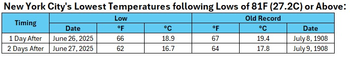
In large part because ocean temperatures are still relatively cool at this time of year, New York City saw the lowest temperature 1 day and 2 days after a low of 81F (27.2C) or higher following a shift in the wind off the water. Records go back to 1869.
-
Yes.
-
Tomorrow will be unseasonably cool. The mercury could struggle to reach 70° in New York City. It should rise into the lower 70s at Newark. The chilly highs will challenge the record for lowest high temperatures two days after an 80° or above low at Central Park, JFK Airport, and Newark. The existing records are below: Central Park: 71°, July 9, 1883 JFK Airport: 76°, July 23, 2019 Newark: 76°, July 23, 2019 All of those readings followed lows of 80° two days earlier. Central Park has had 72 lows of 80° or above; Newark has had 50; and, JFK Airport has had 16. Temperatures will return mainly to the lower 80s for the remainder of June. Excessive heat does not appear likely to return in the near-term. The ENSO Region 1+2 anomaly was +1.0°C and the Region 3.4 anomaly was 0.2°C for the week centered around June 18. For the past six weeks, the ENSO Region 1+2 anomaly has averaged +0.47°C and the ENSO Region 3.4 anomaly has averaged -0.03°C. Neutral ENSO conditions will likely continue through at least late summer. The SOI was +12.65 yesterday. The preliminary Arctic Oscillation (AO) was +1.073 today. Based on sensitivity analysis applied to the latest guidance, there is an implied 93% probability that New York City will have a warmer than normal June (1991-2020 normal). June will likely finish with a mean temperature near 73.1° (1.1° above normal).
-
96 and 5 days of 90 or above.
-
It did not reach 100°. The high was 99°.
-
I agree. The SSTs are hugely important. % of Lows in the 60s one day after an 80° or above low: July 15 or Before: 20.0% (4 out of 20 days) After July 15: 1.9% (1 out of 52 days) July 20 or Later: 0.0% (0 out of 44 days)
-
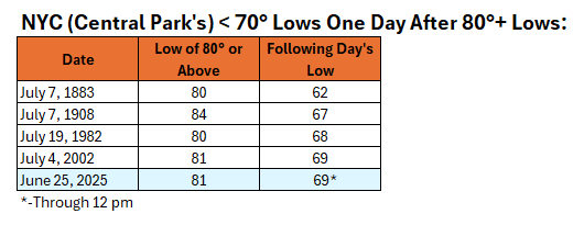
Today is just the 5th day on record that Central Park has seen the temperature fall into the 60s following a day with an 80° or above minimum temperature. There were 72 days with 80° or above lows.
-
The 3 consecutive 100 degree days in 1948 occurred during August 26-28.
-
July 2025 Discussion-OBS - seasonable summer variability
donsutherland1 replied to wdrag's topic in New York City Metro
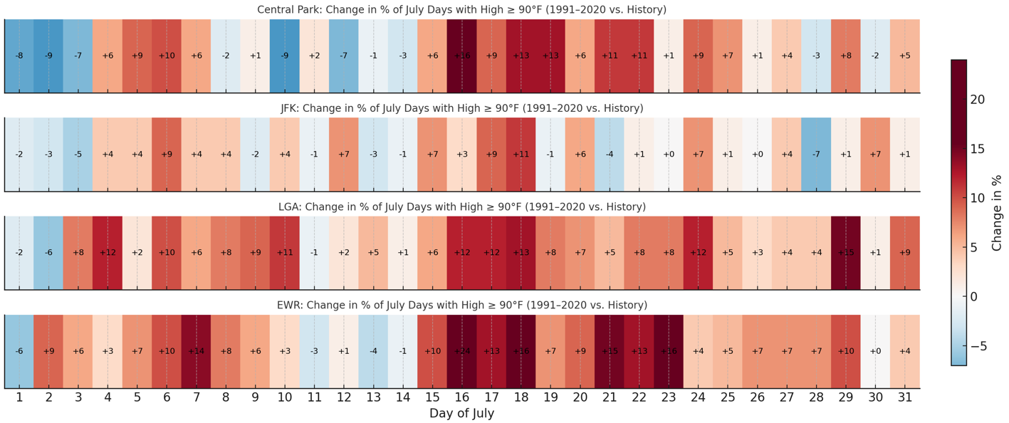
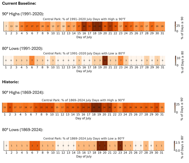
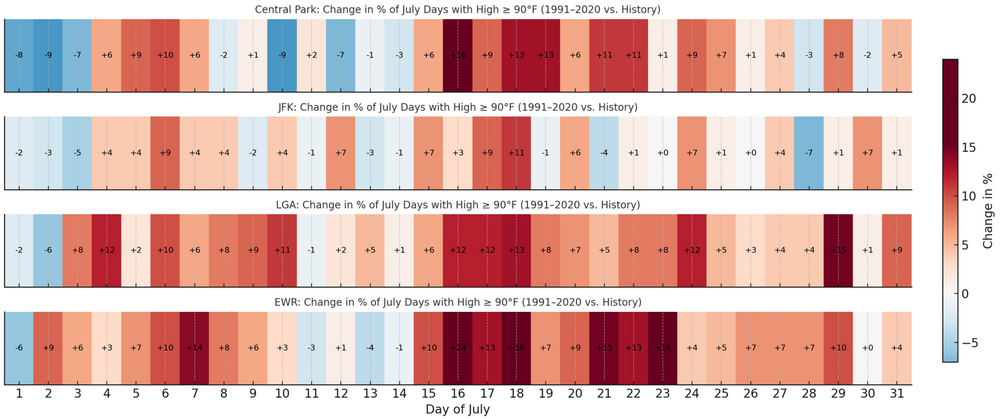
Below is some historic data on the frequency of 90° or above highs and 80° or above lows. The frequency of 90° lows has decreased in parts of the July while increasing during roughly the July 15-25 period. Central Park's dense tree cover has likely contributed to the decreased frequency in parts of July. Central Park has seen 10 days with a decrease, including five days with a greater than 5 percentage point decrease. The nearest station (LaGuardia) has seen an increase on all but 3 days in July. Newark has seen a decrease on only 4 days. Both LaGuardia and Newark saw a decrease of greater than 5 percentage points on one day. JFK is affected by the sea breeze, which adds to the variability. Nevertheless, JFK has seen a greater than 5 percentage point decrease on only one day.
-
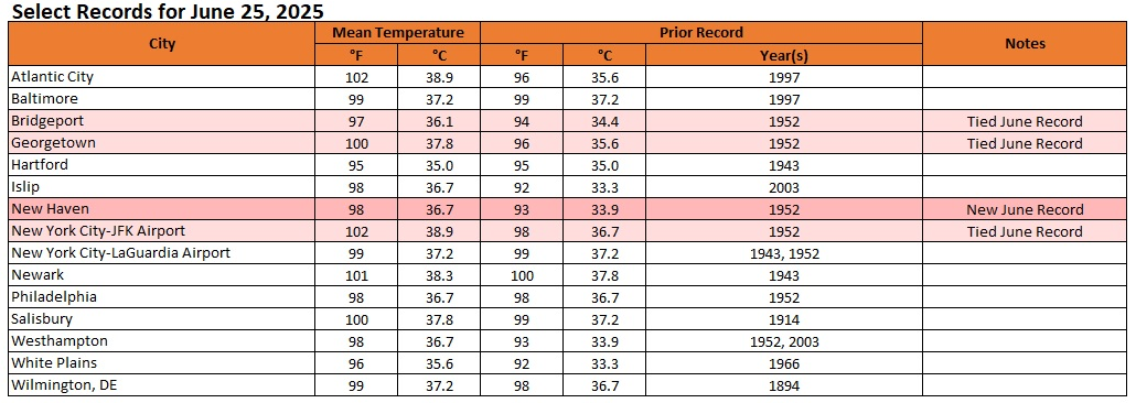
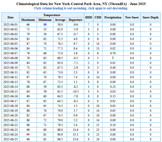
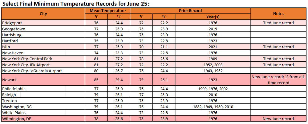
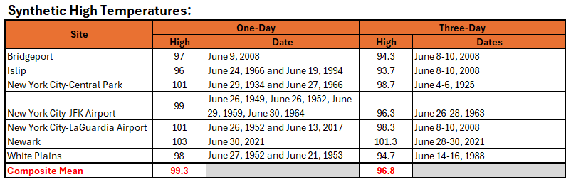
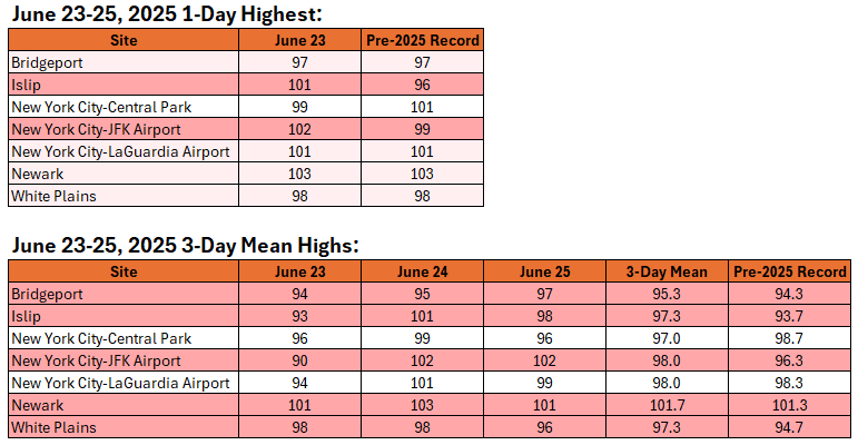
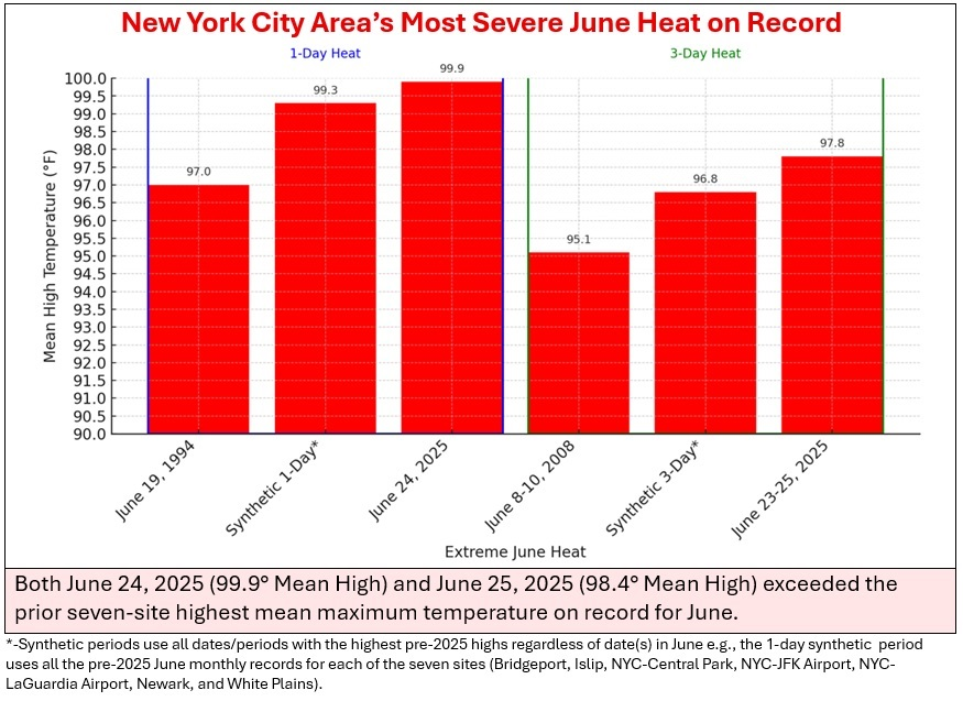
Final Data for the New York City Area’s Most Extreme June Heatwave on Record:
-
All the sites held onto their 80 or above lows yesterday.
-
Yesterday's final low temperatures:
-
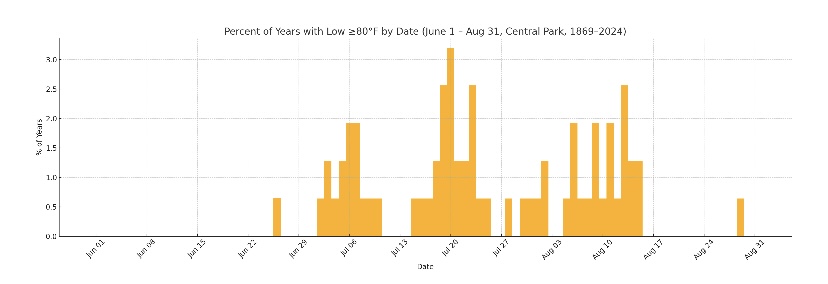
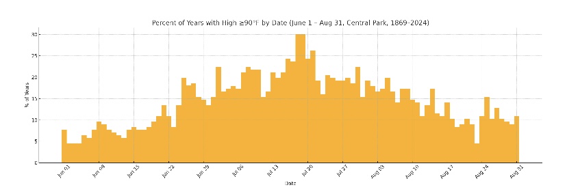
Prior to 2025, here are the frequencies of 80 or above lows and 90 or above highs in Central Park during summer.
-
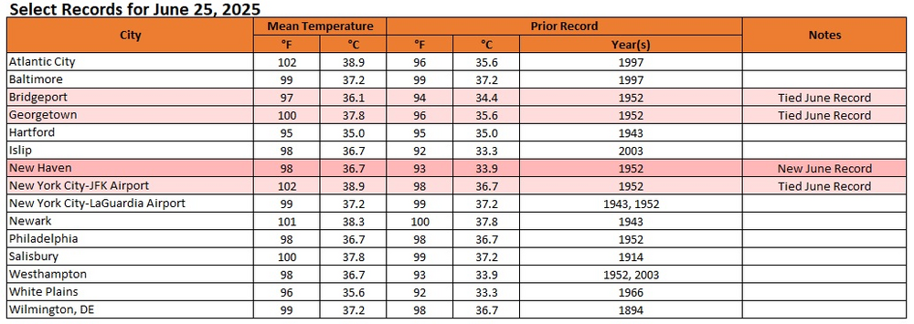
A selection of records from today:
-
The New York City area's most severe June heatwave is now concluding. The June 23-25 period saw the highest composite mean high temperature for the New York City area and the highest 3-day composite mean high temperature. No other event comes close. It even beat the synthetic 1- and 3-day periods. The synthetic 1-day mean temperature included all the pre-2025 highest June temperatures on record for a one-day period. The synthetic 3-day mean temperature include all of the pre-2025 3-day periods with the highest June average high temperatures on record. Comparisons:
-
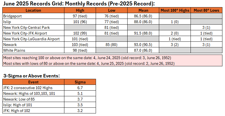
The 30.3" snowstorm (10 sigma) is a rarer event than the back-to-back 102° days in June (6.7 sigma).