donsutherland1
-
Posts
23,987 -
Joined
Content Type
Profiles
Blogs
Forums
American Weather
Media Demo
Store
Gallery
Everything posted by donsutherland1
-
After this morning’s light rain and thunder.

-
3 pm temperatures: JFK: 86 LGA: 85 NYC: 81 EWR: 86 HPN: 86
-
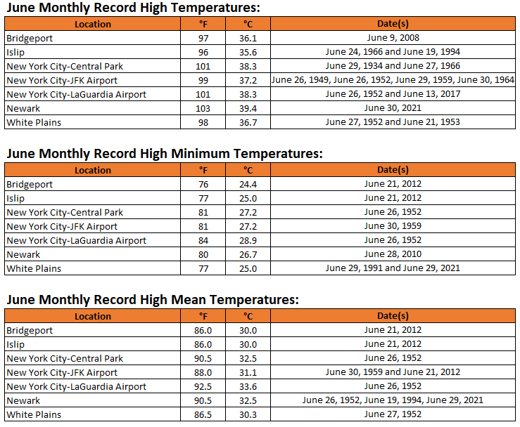
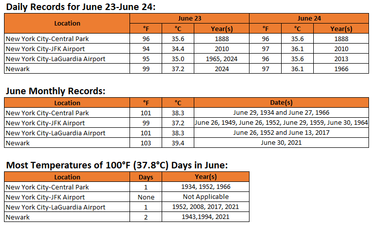
June monthly rainfall and June monthly maximum temperature data for New York City is below:
-
For reference: Washington, DC's most 100° or above temperatures in June is 2. That record was set in 1874 and tied in 1959. Washington, DC's most consecutive 100° or above temperatures in June is 2: June 29-30, 1959. Washington, DC's most recent 100° day in June occurred on June 22, 2024 when the temperature reached 100°. The date with the highest number of 100° readings is June 29th with 4; Second highest is June 9th with 3. The highest temperature on record for June is 104° from June 29, 2012.
-
1953 ran from 8/26 through 9/3. I've added the updated chart.
-
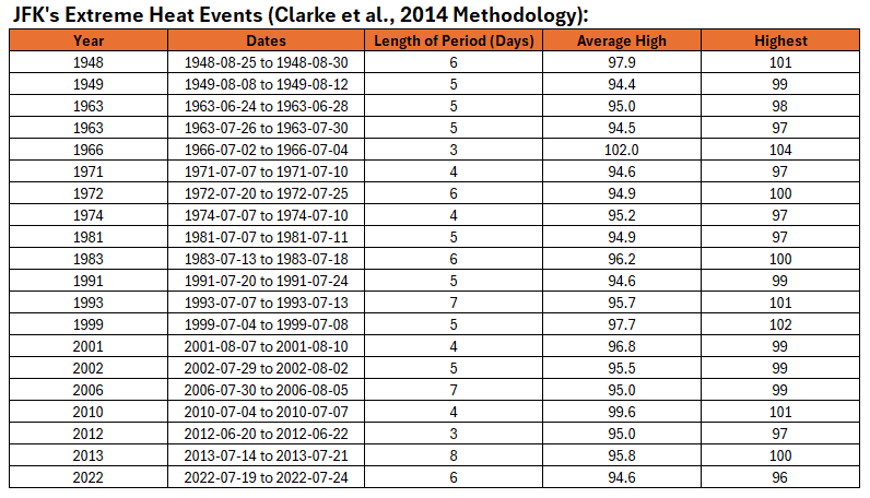
JFK's extreme heat events:
-
The 1948 event would have been shortened to August 26-28, as there were three consecutive 100° highs.
-
I will check out JFK. The thresholds differ from those at Central Park.
-
The value is based on percentile ranking.
-
I believe JFK had a maximum-minimum thermometer, so the high should be accurate even if it occurred between hours.
-
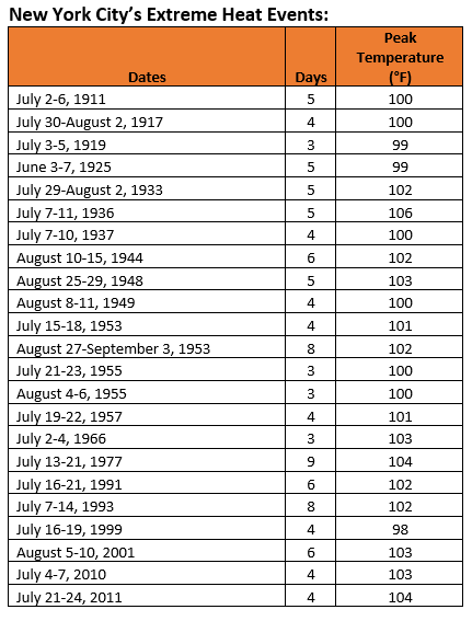
Despite the expected extreme heat, it is possible that New York City's Central Park will fall short of the criteria needed to qualify as an extreme heat event (Clarke et al., 2014 Methodology). To get there, there would need to be at least 3 97° highs, every high during the period would need to be 90° or above, and the average high during the period would need to be 97° or above. Below is a list of such events:
-
The Park will be tough.
-
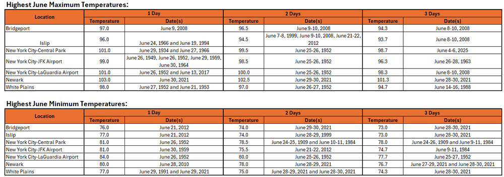
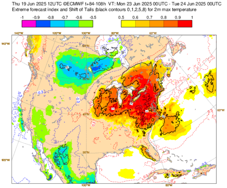
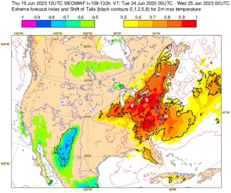
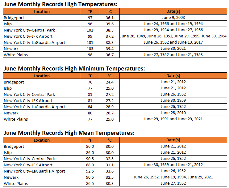
A sustained period of above normal temperatures is now underway. Excessive heat will overspread the region tomorrow with the mercury soaring into the 90s across the region. Extreme heat is likely Monday, Tuesday, and possibly Wednesday Temperatures will likely top out in the middle and upper 90s in the New York City area and upper 90s to lower 100s in the hot spots in New Jersey. The ECMWF and GFS continue to show potential June monthly record heat for parts of the region. June Monthly Records: Bridgeport: 97°, June 9, 2008 Islip: 96°, June 24, 1966 and June 19, 1994 New York City-Central Park: 101°, June 29, 1934 and June 27, 1966 New York City-JFK Airport: 99°, June 29, 1949, June 26, 1952, June 30, 1964 New York City-LaGuardia Airport: 101°, June 26, 1952 and June 13, 2017 Newark: 103°, June 27, 1952 June 26, 1952 is currently the hottest June day on record in and around the New York City area. Out of the five stations from the above list that were operating in 1952, three reached or exceeded 100° on June 26, 1952 (Central Park: 100°, LaGuardia Airport: 101°, and Newark: 102°). All five reached 95° or above. Two stations also saw 80° or above lows: Central Park: 81° and LaGuardia Airport: 84°. Both the number of 100° highs and 80° lows is the highest on record for June for this five-station area. For June 26, 1952, the five-station average high was 99.4°, the average low was 78.2°, and the mean was 88.4°. The average high and mean are the highest on record for June. The average low is the second highest on record for June. June 21, 2012 was the second hottest day, overall, in this region. Its average high was 96.8°. Its average low was 78.4°. Its mean was 87.6°. That average low was the highest on record for June. The average high and mean were the second highest for June. The ENSO Region 1+2 anomaly was +0.5°C and the Region 3.4 anomaly was 0.0°C for the week centered around June 11. For the past six weeks, the ENSO Region 1+2 anomaly has averaged +0.30°C and the ENSO Region 3.4 anomaly has averaged -0.05°C. Neutral ENSO conditions will likely continue through at least late summer. The SOI was +2.11 yesterday. The preliminary Arctic Oscillation (AO) was +0.206 today. Based on sensitivity analysis applied to the latest guidance, there is an implied 84% probability that New York City will have a warmer than normal June (1991-2020 normal). June will likely finish with a mean temperature near 73.8° (1.8° above normal).
-
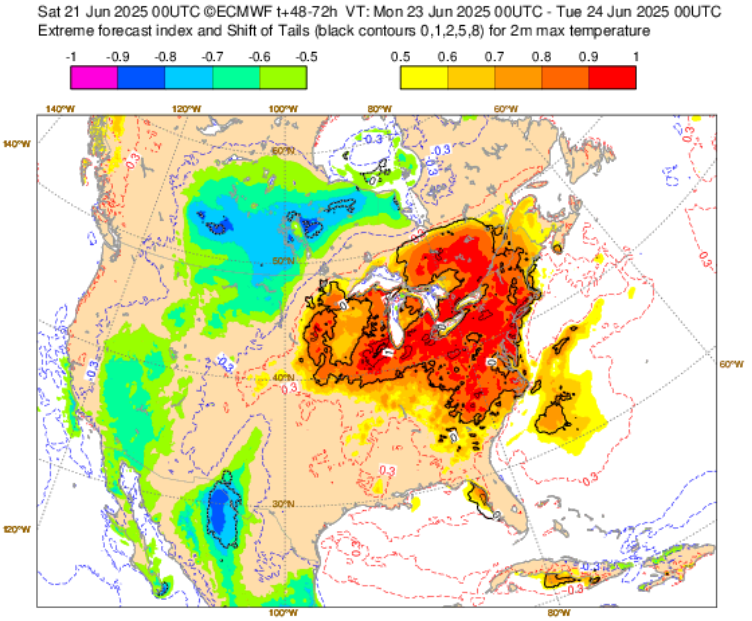
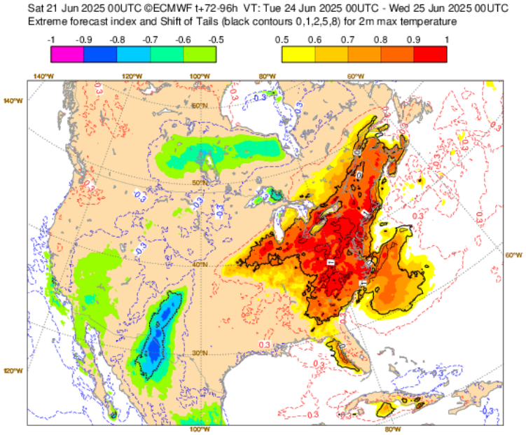
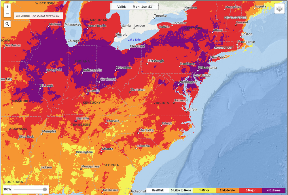
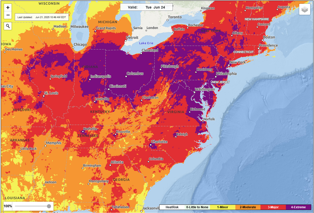
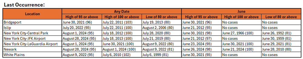
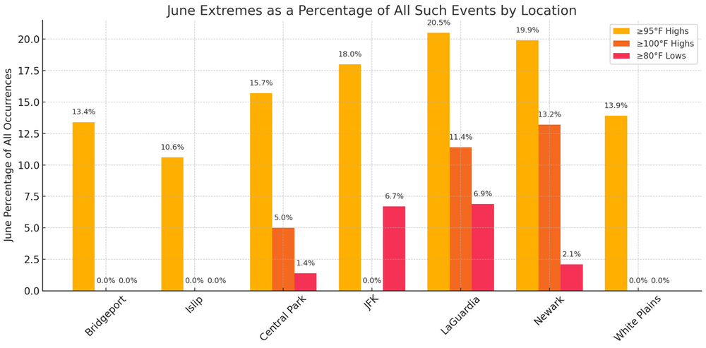
A number of charts and tables for reference for what appears likely to be a notable and perhaps historic bout of June heat: EFI: June 23, 2025: EFI: June 24, 2025: NWS Heat Risk: June 23, 2025: NWS Heat Risk: June 24, 2025: June Monthly Records: June 1-Day, 2-Day, 3-Day Records: Select Additional Data: June Extremes:
-
Yes. I fixed my post as I accidentally omitted 1983 and 2010.
-
Perhaps. Let's say the temperature rises 1.5C to 2.0C from the 1991-2020 average. That would mean, 87°-89° days during 1991-2020 would then be 90° days, on average. That would increase the average annual number of 90° days as follows: JFK: From 10.8 to 22.8; LGA: From 21.8 to 37.9; NYC: From 17.4 to 32.9; Newark: From 28.3 to 46.8. Extremes increase in non-linear fashion, so that actual incidence would probably increase somewhat faster than overall temperatures. So, it seems plausible, but that's far out.
-
JFK Airport 1949: 2 days 1993: 2 days Most in any year: 3 days in 1966, 1983 and 2010 Central Park 1949: 5 days (highest on record) 1993: 3 days Most in any year: 5 days in 1949
-
Even as it is inland relative to NYC, Newark is still on the coastal plain. SSTs are affecting ridge development and placement. The rising moisture may have slowed the rise in high temperatures, but as the climate warms further, the 1949 and 1993 records for 100° days at Newark will likely be broken (perhaps in the next 15 years?). That the climate in the Northeast has grown wetter also has an impact. Both summers were among the driest on record for Newark. The climate models don't do as well on a regional or local basis.
-
Yes. It can happen, especially with an offshore flow. July 23, 1972 is a great example: JFK: 100; Central Park: 94.
-
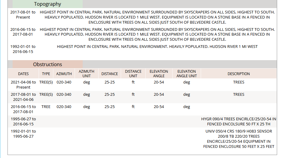
NOAA has noted the obstruction of the trees.

-
The importance of an offshore wind at JFK cannot be overstated. The ultimate June example: June 27, 1966 highs: Central Park: 101; JFK Airport: 82.
-
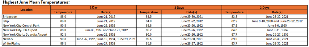
Expanded lists of June record high maximum, minimum, and mean temperatures for the New York City area are below:
-
While New York City waits for the onset of potentially extreme heat, New York City tied the June monthly record for smallest daily temperature range on June 9. The temperature range was just 2° (high: 64°; low: 62°). That tied the June record that was set on June 8, 1869 and tied on June 11, 1910, June 8, 1916, June 20, 1958, and June 17, 1978. June 17, 1978 also had an identical 64°-62° daily range.
-
July 1, 1963 (102).
-
A sustained period of above normal temperatures is now underway. Temperatures will top out in the middle 80s tomorrow. Afterward, the heat will come roaring back on Sunday with the mercury soaring into the 90s across the region. Excessive heat is likely Monday, Tuesday, and possibly Wednesday Temperatures will likely top out in the middle and upper 90s in the New York City area and upper 90s to lower 100s in the hot spots in New Jersey. There remains some uncertainty about the magnitude of the heat. The ECMWF continues to show potential June monthly record heat for parts of the region. The ENSO Region 1+2 anomaly was +0.5°C and the Region 3.4 anomaly was 0.0°C for the week centered around June 11. For the past six weeks, the ENSO Region 1+2 anomaly has averaged +0.30°C and the ENSO Region 3.4 anomaly has averaged -0.05°C. Neutral ENSO conditions will likely continue through at least late summer. The SOI was -6.89 yesterday. The preliminary Arctic Oscillation (AO) was +0.245 today. Based on sensitivity analysis applied to the latest guidance, there is an implied 83% probability that New York City will have a warmer than normal June (1991-2020 normal). June will likely finish with a mean temperature near 73.8° (1.8° above normal).