

donsutherland1
-
Posts
23,987 -
Joined
Content Type
Profiles
Blogs
Forums
American Weather
Media Demo
Store
Gallery
Everything posted by donsutherland1
-
A more practical measure that can be taken now is to assure that NWS offices that provide critical warning are adequately staffed. The extremely short-sighted DOGE staff reductions can endanger lives. https://www.nytimes.com/2025/05/16/weather/nws-cuts-kentucky-tornado.html?unlocked_article_code=1.H08.v8uv.eGs_YqT7fDtY&smid=url-share
-
Thanks. AI chose the processing effect and it seemed to fit the peonies. It has “misses” as well.
-
Mid-month update on the AI idea: It's still too early to be sure about the extent of skill or lack of skill involved in the forecasting realm. In another area, AI continues to progress. It is now able to turn photos of flowers into works approaching fine art. Two examples are below from processed photos taken at the New York Botanical Garden this spring. True photo editing does not yet exist, but could be about a year away. OpenAI is working on it, at present. Other AI companies are likely pursuing similar avenues. Should AI develop true photo editing capabilities that are easy to use, that development could disrupt the market for processing software (Topaz, Photoshop, Paintshop Pro, etc.).


-
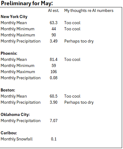
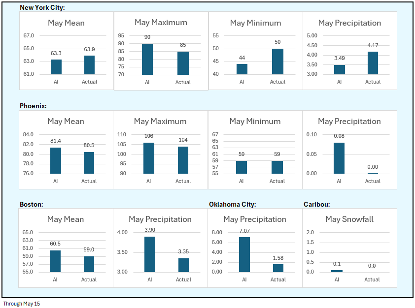
Tomorrow will be unseasonably warm. Temperatures will top out in the upper 70s to perhaps lower 80s. Showers and thundershowers are possible. The extended guidance has grown noticeably cooler for the second half of May than it had been. Both the CFSv2 and ECMWF weekly guidance are now in good agreement that the second half of the month will be cooler than normal overall. Consistent with the guidance, it could turn unseasonably cooler next week following the coming weekend. Once it turns cooler, an extended period of below normal temperatures is possible. The ENSO Region 1+2 anomaly was 0.0°C and the Region 3.4 anomaly was +0.1°C for the week centered around May 7. For the past six weeks, the ENSO Region 1+2 anomaly has averaged +0.55°C and the ENSO Region 3.4 anomaly has averaged -0.07°C. Neutral ENSO conditions will likely continue through at least mid summer. Early indications are that summer 2025 will be warmer than normal in the New York City and Philadelphia areas. The potential exists for a much warmer than normal summer (more than 1° above normal). The SOI was +7.60 yesterday. The preliminary Arctic Oscillation (AO) was -0.278 today. Based on sensitivity analysis applied to the latest guidance, there is an implied near 55% probability that New York City will have a warmer than normal May (1991-2020 normal). May will likely finish with a mean temperature near 63.8° (0.6° above normal).
-
Showers are possible late next week, along with cool readings.
-
It will turn warmer tomorrow. The week will end with temperatures in the upper 70s to perhaps 80°. Showers and thundershowers are possible during the tomorrow and especially on Saturday. The extended guidance has grown noticeably cooler for the second half of May than it had been. Both the CFSv2 and ECMWF weekly guidance are now in good agreement that the second half of the month will be cooler than normal overall. Consistent with the guidance, it could turn unseasonably cooler next week following the coming weekend. Once it turns cooler, an extended period of below normal temperatures is possible. The ENSO Region 1+2 anomaly was 0.0°C and the Region 3.4 anomaly was +0.1°C for the week centered around May 7. For the past six weeks, the ENSO Region 1+2 anomaly has averaged +0.55°C and the ENSO Region 3.4 anomaly has averaged -0.07°C. Neutral ENSO conditions will likely continue through at least mid summer. Early indications are that summer 2025 will be warmer than normal in the New York City and Philadelphia areas. The potential exists for a much warmer than normal summer (more than 1° above normal). The SOI was +7.60 today. The preliminary Arctic Oscillation (AO) was -0.066 today. Based on sensitivity analysis applied to the latest guidance, there is an implied near 55% probability that New York City will have a warmer than normal May (1991-2020 normal). May will likely finish with a mean temperature near 64.0° (0.8° above normal).
-
Showers will wind down later tonight. Although parts of the region picked up 1.00" or more of rain over the past two days, much higher amounts of rainfall were recorded farther south. For example, parts of western Virginia and western North Carolina saw more than 3.50" of rain. Sedalia (4 NW), VA picked up 5.36" of rain. It will turn somewhat warmer tomorrow and the week could end with temperatures in the upper 70s to perhaps 80°. Showers are possible during the weekend. Elsewhere, parts of Texas are experiencing extreme heat. Cotulla, TX reached 112°, which broke the May monthly record of 110° that was set just yesterday. Meanwhile, International Falls reached 91°, its fourth consecutive 90° day. The prior earliest four-day heatwave occurred on June 4-7, 1988 The extended guidance has grown noticeably cooler for the second half of May than it had been. Both the CFSv2 and ECMWF weekly guidance are now in good agreement that the second half of the month could average near or even below normal overall. Consistent with the guidance, it could turn unseasonably cool early next week following the coming weekend. The ENSO Region 1+2 anomaly was 0.0°C and the Region 3.4 anomaly was +0.1°C for the week centered around May 7. For the past six weeks, the ENSO Region 1+2 anomaly has averaged +0.55°C and the ENSO Region 3.4 anomaly has averaged -0.07°C. Neutral ENSO conditions will likely continue through at least mid summer. Early indications are that summer 2025 will be warmer than normal in the New York City and Philadelphia areas. The potential exists for a much warmer than normal summer (more than 1° above normal). The SOI was -3.35 today. The preliminary Arctic Oscillation (AO) was +0.160 today. Based on sensitivity analysis applied to the latest guidance, there is an implied near 66% probability that New York City will have a warmer than normal May (1991-2020 normal). May will likely finish with a mean temperature near 65.0° (1.8° above normal).
-
Showers and thundershowers are likely this evening into tomorrow. It will turn somewhat warmer on Thursday and the week could end with temperatures in the upper 70s to perhaps 80°. Meanwhile, parts of Texas are now experiencing extreme heat. As of 3 pm CDT, daily records were surpassed in Cotulla and Del Rio and the daily record was tied in Houston. The temperature could approach or set new May monthly high temperature records in such cities as Austin, Del Rio and San Antonio tomorrow. The extended guidance has grown cooler for the second half of May than it had been. Both the CFSv2 and ECMWF weekly guidance are now in good agreement that the second half of the month could average near normal overall. The ENSO Region 1+2 anomaly was +0.1°C and the Region 3.4 anomaly was -0.1°C for the week centered around April 30. For the past six weeks, the ENSO Region 1+2 anomaly has averaged +0.68°C and the ENSO Region 3.4 anomaly has averaged -0.05°C. Neutral ENSO conditions will likely continue through at least early summer. Early indications are that summer 2025 will be warmer than normal in the New York City and Philadelphia areas. The potential exists for a much warmer than normal summer (more than 1° above normal). The SOI was +1.47 today. The preliminary Arctic Oscillation (AO) was +0.459 today. Based on sensitivity analysis applied to the latest guidance, there is an implied near 78% probability that New York City will have a warmer than normal May (1991-2020 normal). May will likely finish with a mean temperature near 65.5° (2.3° above normal).
-
It will become mostly cloudy but still dry between 6 am and 8 am. With perhaps a light shower, it should be mainly or completely dry into the evening. Clouds could break for a time on Friday. More sustained clearing should commence Saturday afternoon. At least, that's where things currently stand.
-
Tomorrow will be dry and continued pleasant. Temperatures will generally top out in the lower 70s. Showers and/or thundershowers are possible Tuesday night into Wednesday. It will turn somewhat warmer on Thursday and the week could end with temperatures in the upper 70s to perhaps 80°. Meanwhile, parts of Texas will see extreme heat. The temperature could approach or set new May monthly high temperature records in such cities as Austin, Del Rio and San Antonio on Wednesday. The extended guidance has grown cooler for the second half of May than it had been. Both the CFSv2 and ECMWF weekly guidance are now in good agreement that the second half of the month could average near normal overall. The ENSO Region 1+2 anomaly was +0.1°C and the Region 3.4 anomaly was -0.1°C for the week centered around April 30. For the past six weeks, the ENSO Region 1+2 anomaly has averaged +0.68°C and the ENSO Region 3.4 anomaly has averaged -0.05°C. Neutral ENSO conditions will likely continue through at least early summer. Early indications are that summer 2025 will be warmer than normal in the New York City and Philadelphia areas. The potential exists for a much warmer than normal summer (more than 1° above normal). The SOI was -0.82 today. The preliminary Arctic Oscillation (AO) was +0.718 today. Based on sensitivity analysis applied to the latest guidance, there is an implied near 76% probability that New York City will have a warmer than normal May (1991-2020 normal). May will likely finish with a mean temperature near 65.6° (2.4° above normal).
-
Under bright sunshine, the mercury rose into the middle and upper 70s across the New York City area. Newark topped out at 81°. Tomorrow through much of Tuesday will be dry and pleasant days. Temperatures will generally top out in the lower 70s. Showers and/or thundershowers are possible Tuesday night into Wednesday. It will turn somewhat warmer on Thursday and the week could end with temperatures in the upper 70s to perhaps 80°. Meanwhile, parts of Texas will see extreme heat. The temperature could approach or set new May monthly high temperature records in such cities as Austin, Del Rio and San Antonio. The extended guidance has grown cooler for the second half of May than it had been. Both the CFSv2 and ECMWF weekly guidance are now in good agreement that the second half of the month could average near normal overall. The ENSO Region 1+2 anomaly was +0.1°C and the Region 3.4 anomaly was -0.1°C for the week centered around April 30. For the past six weeks, the ENSO Region 1+2 anomaly has averaged +0.68°C and the ENSO Region 3.4 anomaly has averaged -0.05°C. Neutral ENSO conditions will likely continue through at least early summer. Early indications are that summer 2025 will be warmer than normal in the New York City and Philadelphia areas. The potential exists for a much warmer than normal summer (more than 1° above normal). The SOI was -11.85 today. The preliminary Arctic Oscillation (AO) was +1.173 today. Based on sensitivity analysis applied to the latest guidance, there is an implied near 76% probability that New York City will have a warmer than normal May (1991-2020 normal). May will likely finish with a mean temperature near 65.7° (2.5° above normal).
-
Tomorrow through much of Tuesday will be dry and pleasant days. Tempertures will generally top out in the lower 70s. Some showers are possible Tuesday night into Wednesday. The extended guidance has grown cooler for the second half of May than it had been. Both the CFSv2 and ECMWF weekly guidance are now in good agreement that the second half of the month could average near normal overall. The ENSO Region 1+2 anomaly was +0.1°C and the Region 3.4 anomaly was -0.1°C for the week centered around April 30. For the past six weeks, the ENSO Region 1+2 anomaly has averaged +0.68°C and the ENSO Region 3.4 anomaly has averaged -0.05°C. Neutral ENSO conditions will likely continue through at least early summer. Early indications are that summer 2025 will be warmer than normal in the New York City and Philadelphia areas. The potential exists for a much warmer than normal summer (more than 1° above normal). The SOI was -16.68 today. The preliminary Arctic Oscillation (AO) was +1.220 today. Based on sensitivity analysis applied to the latest guidance, there is an implied near 78% probability that New York City will have a warmer than normal May (1991-2020 normal). May will likely finish with a mean temperature near 65.8° (2.6° above normal). That would tie 2025 with 1975 as the 10th warmest May on record.
-
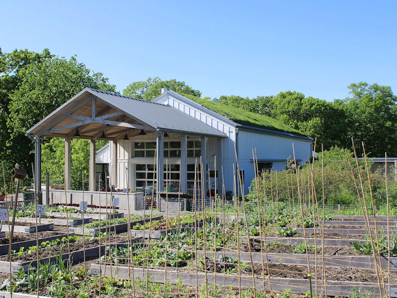
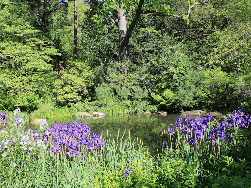
After a morning low of 50°, NYC topped out at a sunny 71°. Even as the rain washed down a lot of the blossoms at the New York Botanical Garden, there were still some picturesque scenes.

-
Showers and periods of rain are likely through at least the first half of tonight. A general storm total 0.50"-1.50" rainfall is likely with some locally higher amounts by the time all of the rain winds down. Following the weekend, it will turn warmer and possibly drier. Some showers will be possible Tuesday night into Wednesday. The ENSO Region 1+2 anomaly was +0.1°C and the Region 3.4 anomaly was -0.1°C for the week centered around April 30. For the past six weeks, the ENSO Region 1+2 anomaly has averaged +0.68°C and the ENSO Region 3.4 anomaly has averaged -0.05°C. Neutral ENSO conditions will likely continue through at least early summer. Early indications are that summer 2025 will be warmer than normal in the New York City and Philadelphia areas. The potential exists for a much warmer than normal summer (more than 1° above normal). The SOI was -13.16 today. The preliminary Arctic Oscillation (AO) was +1.412 today. Based on sensitivity analysis applied to the latest guidance, there is an implied near 78% probability that New York City will have a warmer than normal May (1991-2020 normal). May will likely finish with a mean temperature near 66.0° (2.8° above normal). That would tie 2025 with 1986 as the 9th warmest May on record.
-
Another system will affect the region tomorrow into Saturday before drier air returns. Showers and perhaps some heavy thunderstorms are possible. A general 0.50"-1.50" rainfall is likely with some locally higher amounts. Some of those areas with locally higher amounts could pick up in excess of 3" of rain. Following the weekend, it will turn warmer and possibly drier. Some showers will be possible Tuesday night into Wednesday. The ENSO Region 1+2 anomaly was +0.1°C and the Region 3.4 anomaly was -0.1°C for the week centered around April 30. For the past six weeks, the ENSO Region 1+2 anomaly has averaged +0.68°C and the ENSO Region 3.4 anomaly has averaged -0.05°C. Neutral ENSO conditions will likely continue through at least early summer. Early indications are that summer 2025 will be warmer than normal in the New York City and Philadelphia areas. The potential exists for a much warmer than normal summer (more than 1° above normal). The SOI was +0.48 today. The preliminary Arctic Oscillation (AO) was +1.339 today. Based on sensitivity analysis applied to the latest guidance, there is an implied near 79% probability that New York City will have a warmer than normal May (1991-2020 normal). May will likely finish with a mean temperature near 66.2° (3.0° above normal). That would make 2025 the 9th warmest May on record.
-
Tomorrow will be partly sunny and warm. Temperatures will likely rise into the lower and middle 70s. Another system could affect the region Friday into Saturday before a cooler drier air mass arrives. Showers and perhaps some heavy thunderstorms are possible. A general 0.50"-1.50" rainfall is likely with some locally higher amounts. Following the weekend, it will turn warmer and possibly drier. The ENSO Region 1+2 anomaly was +0.1°C and the Region 3.4 anomaly was -0.1°C for the week centered around April 30. For the past six weeks, the ENSO Region 1+2 anomaly has averaged +0.68°C and the ENSO Region 3.4 anomaly has averaged -0.05°C. Neutral ENSO conditions will likely continue through at least early summer. Early indications are that summer 2025 will be warmer than normal in the New York City and Philadelphia areas. The potential exists for a much warmer than normal summer (more than 1° above normal). The SOI was +5.23 today. The preliminary Arctic Oscillation (AO) was +1.550 today. Based on sensitivity analysis applied to the latest guidance, there is an implied near 75% probability that New York City will have a warmer than normal May (1991-2020 normal). May will likely finish with a mean temperature near 66.0° (2.8° above normal). That would tie 1986 for the 9th warmest May on record.
-
Tomorrow and Thursday will be partly sunny and warmer. Temperatures will likely rise into the lower and middle 70s. Another system could affect the region Friday into Saturday before a cooler drier air mass arrives. Showers and perhaps some heavy thunderstorms are possible. Following the weekend, it will turn warmer and drier. The ENSO Region 1+2 anomaly was +0.1°C and the Region 3.4 anomaly was -0.1°C for the week centered around April 30. For the past six weeks, the ENSO Region 1+2 anomaly has averaged +0.68°C and the ENSO Region 3.4 anomaly has averaged -0.05°C. Neutral ENSO conditions will likely continue through at least early summer. Early indications are that summer 2025 will be warmer than normal in the New York City and Philadelphia areas. The potential exists for a much warmer than normal summer (more than 1° above normal). The SOI was -1.51 today. The preliminary Arctic Oscillation (AO) was +1.509 today.
-
Yes. Almost coast-to-coast warmth.
-
Additional rain is likely tomorrow and Wednesday. It now appears that the dry respite will be brief. Another storm could affect the region Friday into Saturday before a cooler drier air mass arrives. The ENSO Region 1+2 anomaly was +0.1°C and the Region 3.4 anomaly was -0.1°C for the week centered around April 30. For the past six weeks, the ENSO Region 1+2 anomaly has averaged +0.68°C and the ENSO Region 3.4 anomaly has averaged -0.05°C. Neutral ENSO conditions will likely continue through at least early summer. Early indications are that summer 2025 will be warmer than normal in the New York City and Philadelphia areas. The potential exists for a much warmer than normal summer (more than 1° above normal). The SOI was +1.47 today. The preliminary Arctic Oscillation (AO) was +0.778 today.
-
Tomorrow will be rainy and cool. Temperatures will likely top out in the lower and middle 60s. Additional rain is likely into Wednesday before a cooler and drier air mass moves into the region. The coolest air this month could arrive to end the week. It is possible that New York City could see a low temperature near or just below 50° on Friday or Saturday. The ENSO Region 1+2 anomaly was -0.3°C and the Region 3.4 anomaly was 0.0°C for the week centered around April 23. For the past six weeks, the ENSO Region 1+2 anomaly has averaged +0.82°C and the ENSO Region 3.4 anomaly has averaged -0.05°C. Neutral ENSO conditions will likely continue through at least early summer. Early indications are that summer 2025 will be warmer than normal in the New York City and Philadelphia areas. The potential exists for a much warmer than normal summer (more than 1° above normal). The SOI was -2.97 today. The preliminary Arctic Oscillation (AO) was +0.650 today.
-
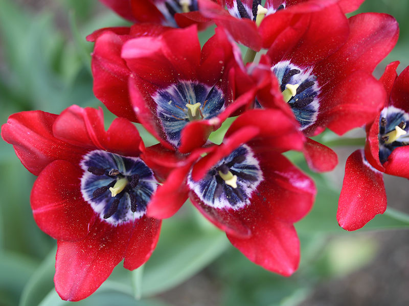
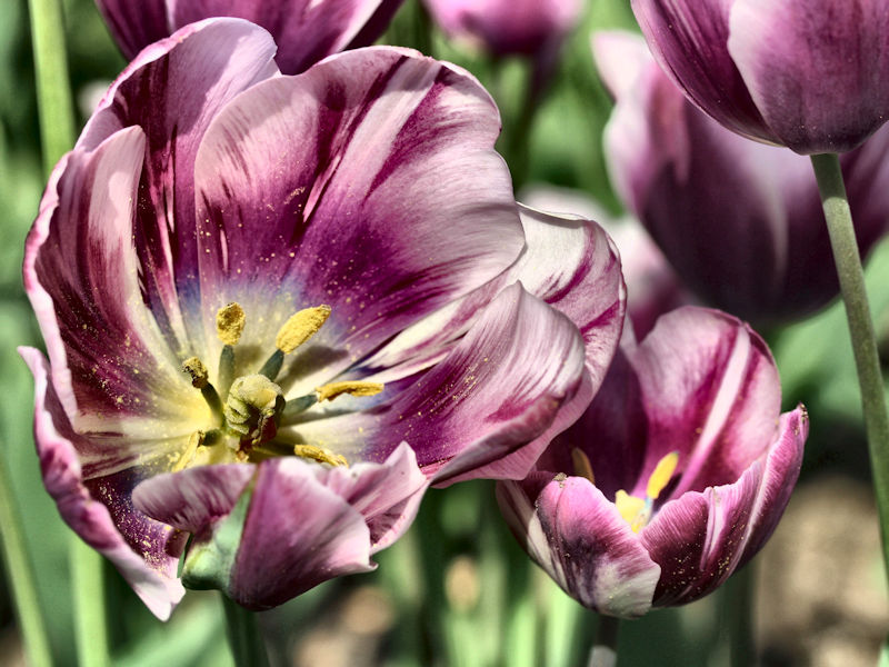
Some of the locations with the tulips also have daffodil bulbs.
-
Today was another exceptionally warm day. Temperatures again rose into the 80s across much of the region. Behind the front, it will turn somewhat cooler tomorrow. A wet pattern is likely tomorrow through Wednesday. A significant rainfall is possible, but there remain large differences among the computer models. The European Model is most aggressive in showing 5" or more rainfall. An early estimate of a general 1"-3" total with locally higher amounts during the Sunday-Wednesday period looks reasonable. The ENSO Region 1+2 anomaly was -0.3°C and the Region 3.4 anomaly was 0.0°C for the week centered around April 23. For the past six weeks, the ENSO Region 1+2 anomaly has averaged +0.82°C and the ENSO Region 3.4 anomaly has averaged -0.05°C. Neutral ENSO conditions will likely continue through at least early summer. Early indications are that summer 2025 will be warmer than normal in the New York City and Philadelphia areas. The potential exists for a much warmer than normal summer (more than 1° above normal). The SOI was -6.88 today. The preliminary Arctic Oscillation (AO) was +0.650 today.
-
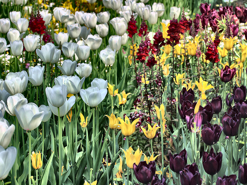
The temperature rose to 85° in New York City. At the New York Botanical Garden, tulips are in peak bloom.


-
Today might be #4.
-
Temperatures soared into the 80s across the region today. New York City's high temperature was 84°. Tomorrow will be another unseasonably warm day. Highs tomorrow will likely reach the lower 80s in New York City and mid 80s in the warmest spots. Afternoon or evening thunderstorms are possible as a cool front drifts across the region. Behind the front, it will turn somewhat cooler on Sunday. A wet pattern is likely Sunday through Wednesday. A significant rainfall is possible, but there remain large differences among the computer models. The European Model is most aggressive in showing 5" or more rainfall. An early estimate of a general 1"-3" total with locally higher amounts during the Sunday-Wednesday period looks reasonable. The ENSO Region 1+2 anomaly was -0.3°C and the Region 3.4 anomaly was 0.0°C for the week centered around April 23. For the past six weeks, the ENSO Region 1+2 anomaly has averaged +0.82°C and the ENSO Region 3.4 anomaly has averaged -0.05°C. Neutral ENSO conditions will likely continue through at least early summer. Early indications are that summer 2025 will be warmer than normal in the New York City and Philadelphia areas. The potential exists for a much warmer than normal summer (more than 1° above normal). The SOI was -4.65 today. The preliminary Arctic Oscillation (AO) was +0.977 today.

