donsutherland1
-
Posts
23,987 -
Joined
Content Type
Profiles
Blogs
Forums
American Weather
Media Demo
Store
Gallery
Everything posted by donsutherland1
-
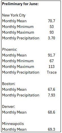
Tomorrow and Tuesday will be variably cloudy and pleasant. Temperatures will top out in the upper 60s to near 70° tomorrow and the middle 70s on Tuesday. Some showers or a thundershower are possible Tuesday afternoon or Tuesday night as a warm front moves across the region. By the middle of the week, it will turn warmer with temperatures again rising into the 80s. Thursday will likely be the warmest day of the week with the mercury rising into at least the middle 80s. The ENSO Region 1+2 anomaly was +0.8°C and the Region 3.4 anomaly was -0.1°C for the week centered around May 28. For the past six weeks, the ENSO Region 1+2 anomaly has averaged +0.17°C and the ENSO Region 3.4 anomaly has averaged -0.07°C. Neutral ENSO conditions will likely continue through at least mid summer. The SOI was +2.46 today. The preliminary Arctic Oscillation (AO) was +1.630 today. Based on sensitivity analysis applied to the latest guidance, there is an implied 61% probability that New York City will have a warmer than normal June (1991-2020 normal). June will likely finish with a mean temperature near 73.2° (1.2° above normal).
-
The temperature rose into the middle 70s at the New York Botanical Garden before clouds and showers moved in during the late afternoon. Some photos:


-
Tomorrow will be partly to mostly cloudy with highs in the middle 70s. Temperatures will continue to top out in the lower and middle 70s through Tuesday. By the middle of the week, it will turn warmer with temperatures again rising into the 80s. The ENSO Region 1+2 anomaly was +0.8°C and the Region 3.4 anomaly was -0.1°C for the week centered around May 28. For the past six weeks, the ENSO Region 1+2 anomaly has averaged +0.17°C and the ENSO Region 3.4 anomaly has averaged -0.07°C. Neutral ENSO conditions will likely continue through at least mid summer. The SOI was -1.41 today. The preliminary Arctic Oscillation (AO) was +1.931 today. Based on sensitivity analysis applied to the latest guidance, there is an implied 62% probability that New York City will have a warmer than normal June (1991-2020 normal). June will likely finish with a mean temperature near 73.3° (1.3° above normal).
-
Showers in Hartsdale.
-
DCA: 100 NYC: 98 BOS: 97 ORD: 98 ATL: 98 IAH: 104 DEN: 102 PHX: 117 SEA: 95
-
It will turn somewhat cooler with high temperatures returning to the upper 70s tomorrow and then middle 70s Sunday and Monday. Showers and thundershowers are possible tomorrow. Rainfall amounts should generally be light except where scattered locations see heavier thunderstorms. By the middle of the week, it will turn warmer with temperatures again rising into the 80s. The ENSO Region 1+2 anomaly was +0.8°C and the Region 3.4 anomaly was -0.1°C for the week centered around May 28. For the past six weeks, the ENSO Region 1+2 anomaly has averaged +0.17°C and the ENSO Region 3.4 anomaly has averaged -0.07°C. Neutral ENSO conditions will likely continue through at least mid summer. The SOI was -1.13 today. The preliminary Arctic Oscillation (AO) was +1.967 today.
-
Tomorrow will be another warm day with the temperature rising into the lower and perhaps middle 80s. A shower or thunderstorm is possible during the afternoon or evening. The weekend will turn somewhat cooler with high temperatures returning to the 70s. Showers and thundershowers are possible during the weekend. Rainfall amounts should generally be light except where scattered locations see heavier thunderstorms. The ENSO Region 1+2 anomaly was +0.8°C and the Region 3.4 anomaly was -0.1°C for the week centered around May 28. For the past six weeks, the ENSO Region 1+2 anomaly has averaged +0.17°C and the ENSO Region 3.4 anomaly has averaged -0.07°C. Neutral ENSO conditions will likely continue through at least mid summer. The SOI was +7.45 today. The preliminary Arctic Oscillation (AO) was +1.874 today.
-
Newark has reached 90° for the first time this year.
-
Tomorrow will be the hottest day so far in parts of the region. Parts of the region could reach 90° for their first time this year. Temperatures will remain above normal into the weekend when high temperatures will return to the 70s. Showers and thundershowers are possible during the weekend. Rainfall amounts should generally be light except where scattered locations see heavier thunderstorms. The ENSO Region 1+2 anomaly was +0.2°C and the Region 3.4 anomaly was -0.2°C for the week centered around May 21. For the past six weeks, the ENSO Region 1+2 anomaly has averaged +0.08°C and the ENSO Region 3.4 anomaly has averaged -0.08°C. Neutral ENSO conditions will likely continue through at least mid summer. The SOI was +11.32 today. The preliminary Arctic Oscillation (AO) was +1.773 today.
-
A dramatic warmup is underway. The temperature will soar into the 80s tomorrow. The temperature could reach the hottest levels so far this year on Thursday. Parts of the region could reach 90° for their first time this year. Temperatures will remain above normal into the weekend when high temperaturss will return to the 70s. Showers and thundershowers are possible during the weekend. The ENSO Region 1+2 anomaly was +0.2°C and the Region 3.4 anomaly was -0.2°C for the week centered around May 21. For the past six weeks, the ENSO Region 1+2 anomaly has averaged +0.08°C and the ENSO Region 3.4 anomaly has averaged -0.08°C. Neutral ENSO conditions will likely continue through at least mid summer. The SOI was +4.57 today. The preliminary Arctic Oscillation (AO) was +1.693 today.
-
A dramatic warmup will is now imminent. The temperature will soar into the upper 70s to around 80° tomorrow and into the 80s by Wednesday. The temperature could reach the hottest levels so far this year on Thursday. Parts of the region could reach 90° for their first time this year. Temperatures will remain above normal into the weekend. The ENSO Region 1+2 anomaly was +0.2°C and the Region 3.4 anomaly was -0.2°C for the week centered around May 21. For the past six weeks, the ENSO Region 1+2 anomaly has averaged +0.08°C and the ENSO Region 3.4 anomaly has averaged -0.08°C. Neutral ENSO conditions will likely continue through at least mid summer. The SOI was -6.75 today. The preliminary Arctic Oscillation (AO) was +1.534 today.
-
Here's the data:
-
June got off to a chilly start. Outside New York City, lows in the 40s were commonplace. New York City saw the temperature dip to 50°. Danbury and White Plains both saw lows of 48°. Tonight will be another unseasonably cool night. Some areas outside New York City could again see the mercury dip into the 40s. Tomorrow will turn milder with the temperature reaching or exceeding 70°. Afterward, a dramatic warmup will rapidly unfold. Above normal temperatures will develop near midweek. The temperature could reach the hottest levels so far this year on Thursday. Parts of the region could reach 90° for their first time this year. The ENSO Region 1+2 anomaly was +0.2°C and the Region 3.4 anomaly was -0.2°C for the week centered around May 21. For the past six weeks, the ENSO Region 1+2 anomaly has averaged +0.08°C and the ENSO Region 3.4 anomaly has averaged -0.08°C. Neutral ENSO conditions will likely continue through at least mid summer. The SOI was -1.83 today. The preliminary Arctic Oscillation (AO) was +1.308 today.
-
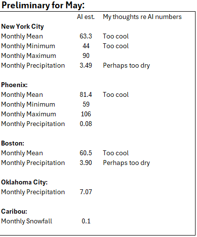
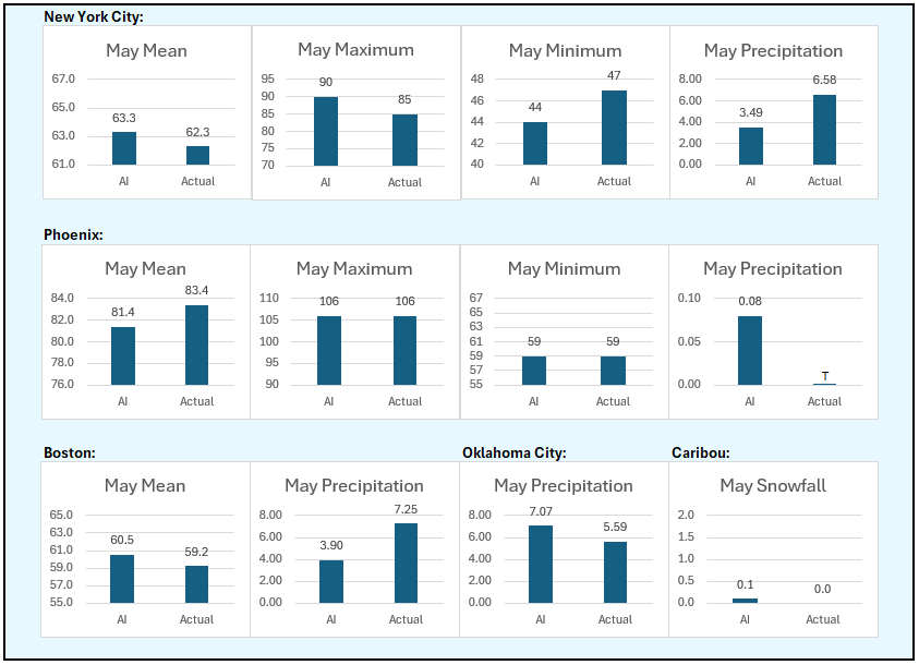
The final AI verification for May:
-
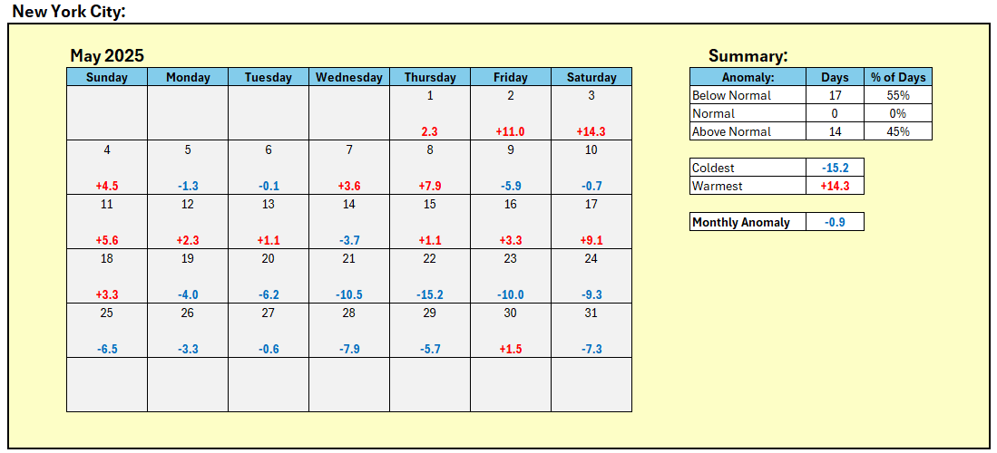
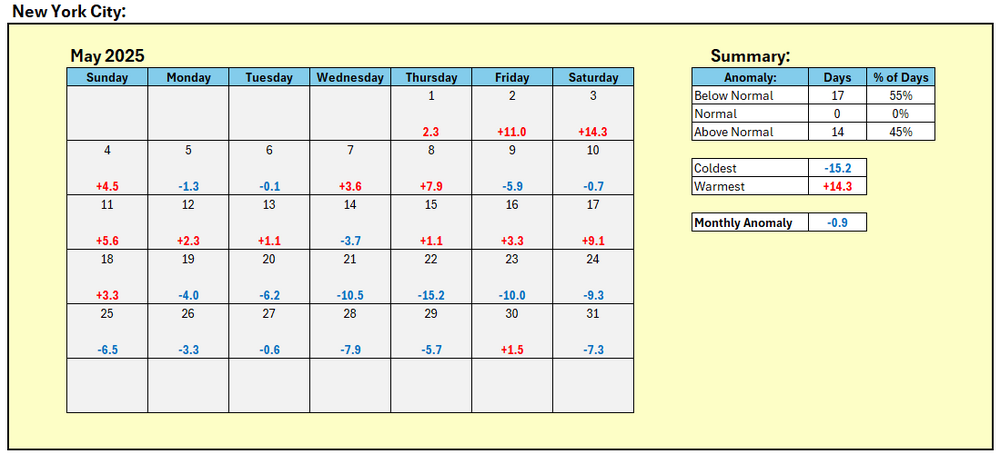
May was essentially a tale of two months in NYC. The first half was very warm. The second half was very cool.
-
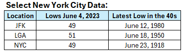
June 4, 2023.
-
Inside the City, it’s uncommon. The last time it happened was in 2023. Before that, it was 2000.
-
Cooler than normal temperatures will prevail from tomorrow through early next week. Tomorrow morning will be particularly cool with readings falling into the 40s outside of New York City and lower 50s in New York City. Above normal temperatures will likely develop near the middle of next week. The temperature could reach the hottest levels so far this year on Thursday. June looks to be warmer than normal on the CFSv2. However, just as had been the case for May, the AI guidance is notably cooler than the conventional models. The ENSO Region 1+2 anomaly was +0.2°C and the Region 3.4 anomaly was -0.2°C for the week centered around May 21. For the past six weeks, the ENSO Region 1+2 anomaly has averaged +0.08°C and the ENSO Region 3.4 anomaly has averaged -0.08°C. Neutral ENSO conditions will likely continue through at least mid summer. The SOI was +0.94 today. The preliminary Arctic Oscillation (AO) was +1.381 today.
-
Probably not. However, I suspect that those June numbers are too low given the guidance. However, that’s the way things stood at the end of April. The AI idea schooled the EPS. If the AI idea again proves much better than the guidance, that might offer a hint of skill. I would still like to see a lot more data before reaching firm conclusions.
-
AI numbers for June. These numbers will again be verified at the end of the month. They appear to be noticeably cooler than the guidance in New York City and Boston. That was the case in May, and May will be cooler than the guidance. It's too soon to speculate about skill or lack of skill.
-
DCA _ NYC _ BOS ___ ORD _ ATL _ IAH ___ DEN _ PHX _ SEA 1.6 2.2 2.3 2.6 0.2 0.8 0.4 1.3 0.5
-
Showers and thunderstorms are likely tonight and tomorrow. A general 0.50"-1.50" storm total rainfall is likely. Some areas could see locally higher amounts where some flooding is possible. Cooler than normal temperatures will prevail from tomorrow through early next week. Above normal temperatures will likely develop near the middle of next week. June looks to be warmer than normal on the CFSv2. However, just as had been the case for May, the AI guidance is notably cooler than the conventional models. The ENSO Region 1+2 anomaly was +0.2°C and the Region 3.4 anomaly was -0.2°C for the week centered around May 21. For the past six weeks, the ENSO Region 1+2 anomaly has averaged +0.08°C and the ENSO Region 3.4 anomaly has averaged -0.08°C. Neutral ENSO conditions will likely continue through at least mid summer. Early indications are that summer 2025 will be warmer than normal in the New York City and Philadelphia areas. The potential exists for a much warmer than normal summer (more than 1° above normal). The SOI was +5.46 today. The preliminary Arctic Oscillation (AO) was +1.688 today. Based on sensitivity analysis applied to the latest guidance, there is an implied near 100% probability that New York City will have a cooler than normal May (1991-2020 normal). May will likely finish with a mean temperature near 62.5° (0.7° below normal).
-
Tomorrow will be variably cloudy and warmer. Readings will likely top out in the middle 70s in the New York City area. Additional showers and thundershowers are likely tomorrow night and Saturday. Cooler than normal temperatures will prevail through the remainder of the month with the exception of tomorrow. Above normal temperatures could develop near the middle of next week. June looks to be warmer than normal on the CFSv2. However, just as had been the case for May, the AI guidance is notably cooler than the conventional models. The ENSO Region 1+2 anomaly was +0.2°C and the Region 3.4 anomaly was -0.2°C for the week centered around May 21. For the past six weeks, the ENSO Region 1+2 anomaly has averaged +0.08°C and the ENSO Region 3.4 anomaly has averaged -0.08°C. Neutral ENSO conditions will likely continue through at least mid summer. Early indications are that summer 2025 will be warmer than normal in the New York City and Philadelphia areas. The potential exists for a much warmer than normal summer (more than 1° above normal). The SOI was +21.54 today. The preliminary Arctic Oscillation (AO) was +1.977 today. Based on sensitivity analysis applied to the latest guidance, there is an implied near 97% probability that New York City will have a cooler than normal May (1991-2020 normal). May will likely finish with a mean temperature near 62.6° (0.6° below normal).
-
Showers will continue into tomorrow. An additional round of showers and thundershowers is possible Friday night and Saturday. Cooler than normal temperatures will prevail through the remainder of the month with the exception of Friday. Meanwhile daily record and possible monthly record heat could develop for Friday and Saturday in such cities as Redding and Sacramento. June looks to be warmer than normal on the CFSv2. However, just as had been the case for May, the AI guidance is notably cooler than the conventional models. The ENSO Region 1+2 anomaly was +0.2°C and the Region 3.4 anomaly was -0.2°C for the week centered around May 21. For the past six weeks, the ENSO Region 1+2 anomaly has averaged +0.08°C and the ENSO Region 3.4 anomaly has averaged -0.08°C. Neutral ENSO conditions will likely continue through at least mid summer. Early indications are that summer 2025 will be warmer than normal in the New York City and Philadelphia areas. The potential exists for a much warmer than normal summer (more than 1° above normal). The SOI was +25.07 today. The preliminary Arctic Oscillation (AO) was +2.238 today. Based on sensitivity analysis applied to the latest guidance, there is an implied near 83% probability that New York City will have a cooler than normal May (1991-2020 normal). May will likely finish with a mean temperature near 62.7° (0.5° below normal).
-
Occasional Thoughts on Climate Change
donsutherland1 replied to donsutherland1's topic in Climate Change
Right now, it’s not viable for addressing the issue on earth. https://science.nasa.gov/climate-change/faq/can-new-nasa-carbon-to-oxygen-conversion-technology-like-moxie-be-used-to-address-climate-change/