

donsutherland1
-
Posts
23,987 -
Joined
Content Type
Profiles
Blogs
Forums
American Weather
Media Demo
Store
Gallery
Everything posted by donsutherland1
-
Timing has an impact.
-
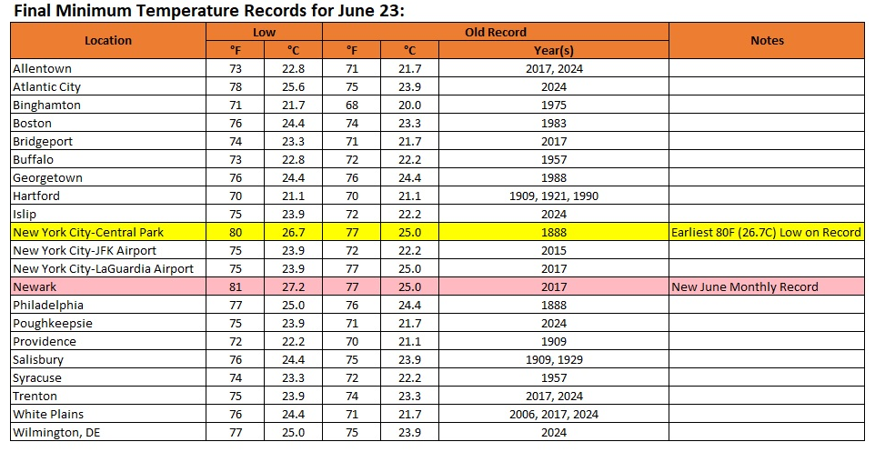
Final low temperatures for yesterday and preliminary low temperatures for today:
-
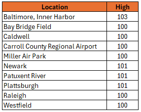
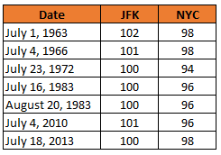
Below is a list of some of the locations reaching 100° or above in the East:
-
Actually, the coefficients of determination are very high in June: JFK: 0.51; LGA: 0.61; NYC: 0.55. For JFK and NYC, every degree increase in the June low translates into a 1.0 degree rise in the high. For LGA, every degree increase translates into a 1.1 degree rise in the high during June.
-
Plattsburgh reached 101° today. That tied the all-time record that was set August 5, 1955 and tied on August 1, 1975 and August 2, 1975.
-
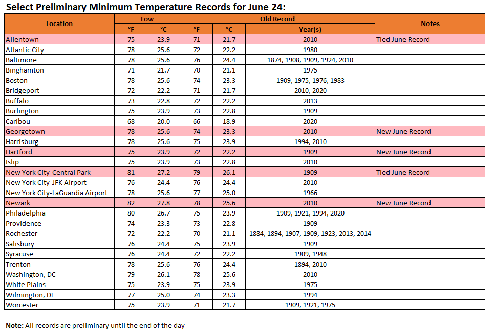
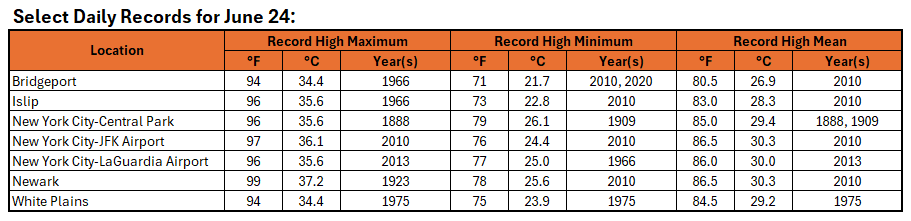
Today's records and a preview of tomorrow's New York City area records:
-
Unfortunately, I can’t. The data should be available by 8 pm.
-
No. We’ll see if Philadelphia can still get there today.
-
Mount Pocono reached 93 setting a new June monthly record high.
-
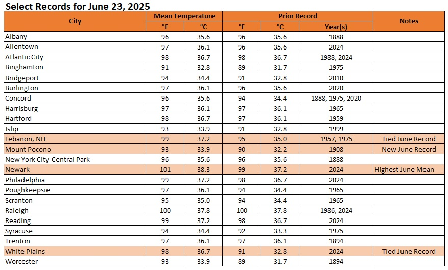
Today was the appetizer for what could be a day of historic June heat tomorrow. Extreme heat is likely tomorrow and possibly Wednesday Temperatures will likely top out in the upper 90s in much of the New York City area and lower to middle 100s in the hot spots in New Jersey tomorrow. Numerous locations could challenge or set new June monthly temperature records. June Monthly Records: Bridgeport: 97°, June 9, 2008 Islip: 96°, June 24, 1966 and June 19, 1994 New York City-Central Park: 101°, June 29, 1934 and June 27, 1966 New York City-JFK Airport: 99°, June 29, 1949, June 26, 1952, June 30, 1964 New York City-LaGuardia Airport: 101°, June 26, 1952 and June 13, 2017 Newark: 103°, June 27, 1952 June 26, 1952 is currently the hottest June day on record in and around the New York City area. Out of the five stations from the above list that were operating in 1952, three reached or exceeded 100° on June 26, 1952 (Central Park: 100°, LaGuardia Airport: 101°, and Newark: 102°). All five reached 95° or above. Two stations also saw 80° or above lows: Central Park: 81° and LaGuardia Airport: 84°. Both the number of 100° highs and 80° lows is the highest on record for June for this five-station area. For June 26, 1952, the five-station average high was 99.4°, the average low was 78.2°, and the mean was 88.4°. The average high and mean are the highest on record for June. The average low is the second highest on record for June. June 21, 2012 was the second hottest day, overall, in this region. Its average high was 96.8°. Its average low was 78.4°. Its mean was 87.6°. That average low was the highest on record for June. The average high and mean were the second highest for June. The ENSO Region 1+2 anomaly was +1.0°C and the Region 3.4 anomaly was 0.2°C for the week centered around June 18. For the past six weeks, the ENSO Region 1+2 anomaly has averaged +0.47°C and the ENSO Region 3.4 anomaly has averaged -0.03°C. Neutral ENSO conditions will likely continue through at least late summer. The SOI was +13.85 yesterday. The preliminary Arctic Oscillation (AO) was +1.425 today. Based on sensitivity analysis applied to the latest guidance, there is an implied 80% probability that New York City will have a warmer than normal June (1991-2020 normal). June will likely finish with a mean temperature near 73.2° (1.2° above normal).
-
So far, the high there is 91.
-
Winds varied from west-southwest to northwest.
-
JFK was the hot spot in the area. Bridgeport: 94° Islip: 94° Central Park: 94° JFK: 100° LaGuardia: 91° Newark: 96° White Plains: 86°
-
Seven days:
-
The blackout began on July 13, 1977. The high that day was 93°.
-
1.76" on July 18, 2012. The rain was associated with a cold front that crossed the region after the high had been reached.
-
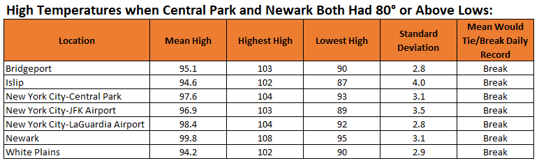
Today is the first June day on record where both Newark and New York City (Central Park) had low temperatures of 80° or above. The last such occurrence was July 28, 2020. Overall, it is the 32nd such case during the common period for their records. Below is a chart showing the mean high temperature, highest maximum temperature, and lowest maximum temperature for such cases.
-
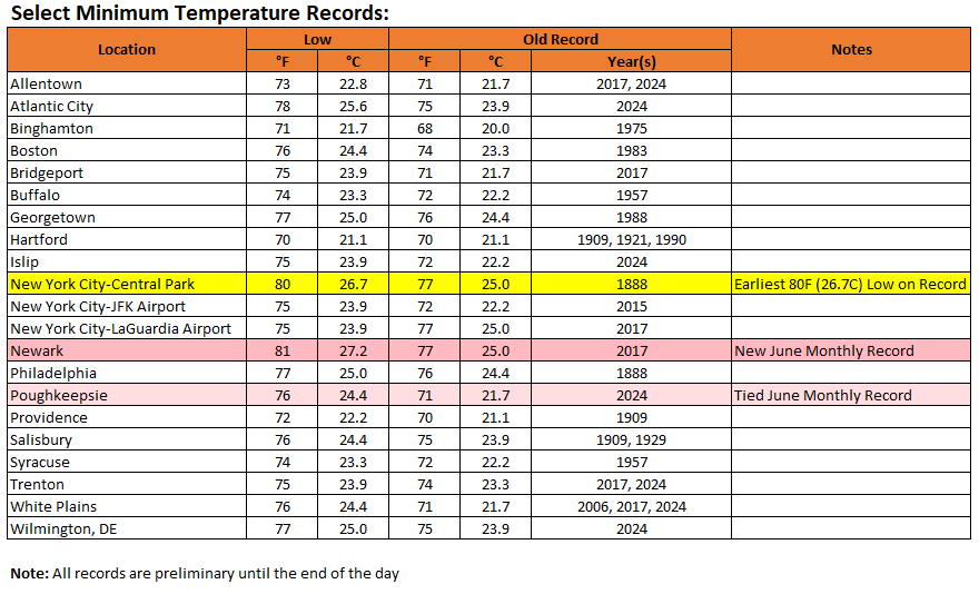
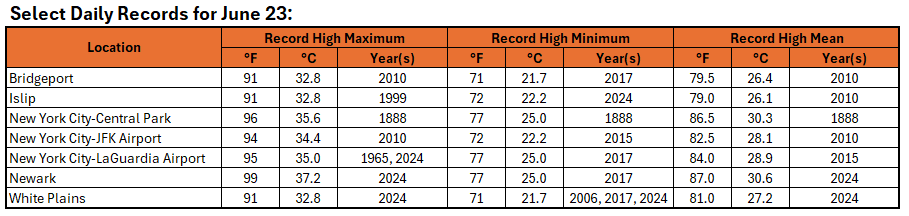
Newark's 81° low set a new June monthly record. The old record was 80°. That mark was set on June 28, 2010. Central Park recorded its earliest 80° low on record. The prior mark was set on June 26, 1952. A list of select records is below:
-
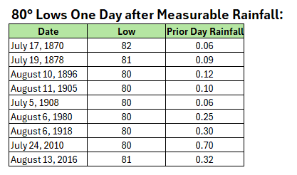
Today is on track to become New York City's 10th occurrence with a low temperature of 80° or above one day after measurable rainfall. It would be the first such occurrence in June. The list is below:
-
I don't believe today's light rainfall (0.10" at NYC, 0.08" at LGA and JFK, and 0.06" at Newark) will have much impact on Tuesday's high temperatures. Looking back at Central Park's long record, there were 6 100° days two days after measurable precipitation. In fact, on July 20, 1977, 0.06" rain fell. July 21, 1977 saw the mercury hit 104°. The most precipitation that fell two days before a 100° high was 0.36"; the most precipitation that fell one day before a 100° high was 0.16". The highest temperature two days after 1" or more rain was 99°; the highest temperature one day after 1" or more rain was 97°. The highest temperature two days after 2" or more rain was 95°; the highest temperature one day after 2" or more rain was 93°. Both those cases followed 3" or above rainfall. The highest temperature two days after 4" or more rain was 89°; the highest temperature one day after 4" or more rain was 87°. In short, heavier rainfall would have an impact. The light rainfall that occurred today shouldn't have much impact. The development of a sea breeze, cloud cover, and/or humidity will have a larger impact.
-
For reference for tomorrow:
-
Bridgeport reached 93 today. That tied its daily record from 1949.
-
JFK Airport (91°), LaGuardia Airport (90°), and Newark (92°) all reached 90° or above while Central Park (88°) did not. That was the second time this month that happened. The last month with two such days was August 2021. The record is 4 such days in June 2010. Even more impressive, Bridgeport, JFK Airport, LaGuardia Airport, Islip, and Newark all reached 90° or higher, while Central Park did not for the first time since June 17, 2022 and only the 12th time during the period of common recordkeeping. The 5° difference between Brigeport (93°) and Central Park (88°) was just 1° short of the record for all days where Bridgeport reached 90° or above and Central Park did not. That record was set on June 24, 2017: Bridgeport: 90°; Central Park: 84°. During the period of common recordkeeping, there have been 149 days when JFK reached 90° or higher and Central Park did not. In contrast, there have been 722 days when Central Park reached 90°F or higher and JFK did not. There have been 46 days when Bridgeport reached 90° or higher and Central Park did not. In contrast, there have been 663 days when Central Park reached 90°F or higher and Bridgeport did not.There have been 38 days when Islip reached 90° or higher and Central Park did not. In contrast, there have been 702 days when Central Park reached 90°F or higher and Islip did not.
-
Following this morning's showers and thundershowers, heat began surging into the region. Through 5 pm, highs at JFK Airport and Newark had reached 91°. Extreme heat is likely tomorrow, Tuesday, and possibly Wednesday Temperatures will likely top out in the middle and upper 90s in the New York City area and upper 90s to lower 100s in the hot spots in New Jersey during the height of the heat on Tuesday. The ECMWF and GFS continue to show potential June monthly record heat for parts of the region. June Monthly Records: Bridgeport: 97°, June 9, 2008 Islip: 96°, June 24, 1966 and June 19, 1994 New York City-Central Park: 101°, June 29, 1934 and June 27, 1966 New York City-JFK Airport: 99°, June 29, 1949, June 26, 1952, June 30, 1964 New York City-LaGuardia Airport: 101°, June 26, 1952 and June 13, 2017 Newark: 103°, June 27, 1952 June 26, 1952 is currently the hottest June day on record in and around the New York City area. Out of the five stations from the above list that were operating in 1952, three reached or exceeded 100° on June 26, 1952 (Central Park: 100°, LaGuardia Airport: 101°, and Newark: 102°). All five reached 95° or above. Two stations also saw 80° or above lows: Central Park: 81° and LaGuardia Airport: 84°. Both the number of 100° highs and 80° lows is the highest on record for June for this five-station area. For June 26, 1952, the five-station average high was 99.4°, the average low was 78.2°, and the mean was 88.4°. The average high and mean are the highest on record for June. The average low is the second highest on record for June. June 21, 2012 was the second hottest day, overall, in this region. Its average high was 96.8°. Its average low was 78.4°. Its mean was 87.6°. That average low was the highest on record for June. The average high and mean were the second highest for June. The ENSO Region 1+2 anomaly was +0.5°C and the Region 3.4 anomaly was 0.0°C for the week centered around June 11. For the past six weeks, the ENSO Region 1+2 anomaly has averaged +0.30°C and the ENSO Region 3.4 anomaly has averaged -0.05°C. Neutral ENSO conditions will likely continue through at least late summer. The SOI was +8.58 yesterday. The preliminary Arctic Oscillation (AO) was +0.777 today. Based on sensitivity analysis applied to the latest guidance, there is an implied 79% probability that New York City will have a warmer than normal June (1991-2020 normal). June will likely finish with a mean temperature near 73.4° (1.4° above normal).
-
Manor Park in Larchmont

