donsutherland1
-
Posts
23,987 -
Joined
Content Type
Profiles
Blogs
Forums
American Weather
Media Demo
Store
Gallery
Everything posted by donsutherland1
-
I agree. Once we get through the cooler period, I suspect some of the heat will move into the region.
-
There likely will be a period where it is dry on Sunday.
-
Tomorrow and Saturday will be unseasonably warm with tomorrow being the wwarmer of the two days. Highs tomorrow will likely reah the lower 80s in New York City and mid 80s in the warmest spots. It will turn somewhat cooler on Sunday. A wet pattern is likely Sunday through Wednesday. A significant rainfall is possible, but there remain large differences among the computer models. The ENSO Region 1+2 anomaly was -0.3°C and the Region 3.4 anomaly was 0.0°C for the week centered around April 23. For the past six weeks, the ENSO Region 1+2 anomaly has averaged +0.82°C and the ENSO Region 3.4 anomaly has averaged -0.05°C. Neutral ENSO conditions will likely continue through at least early summer. Early indications are that summer 2025 will be warmer than normal in the New York City and Philadelphia areas. The potential exists for a much warmer than normal summer (more than 1° above normal). The SOI was -4.19 today. The preliminary Arctic Oscillation (AO) was +1.598 today.
-
April AI vs. Actual Outcomes: AI showed a cool bias for the monthly mean temperatures. The extent of "skill" it has in monthly forecasts remains uncertain.

-
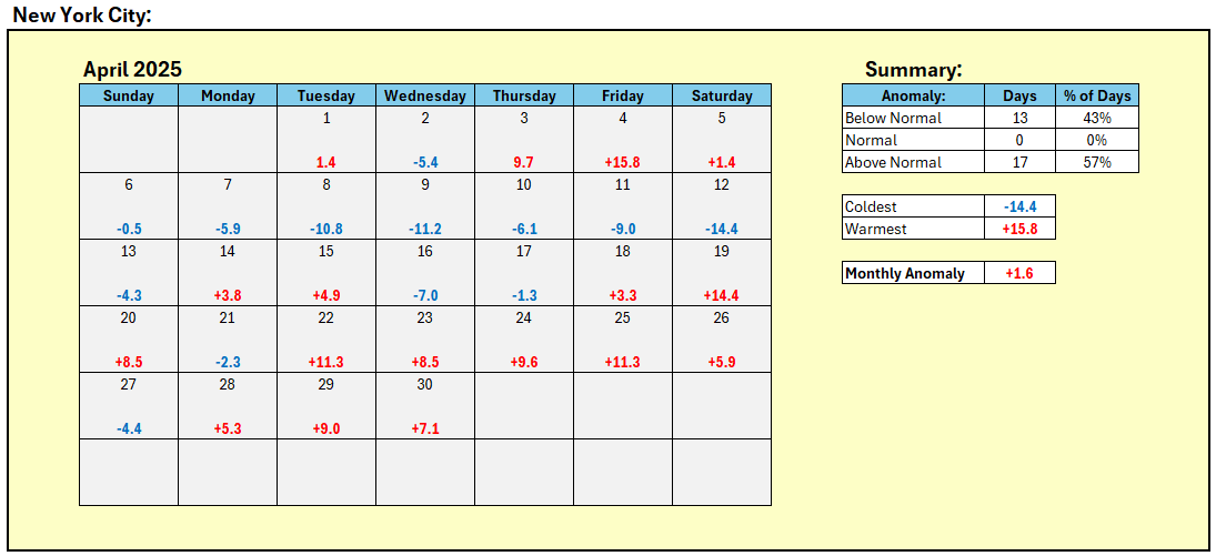
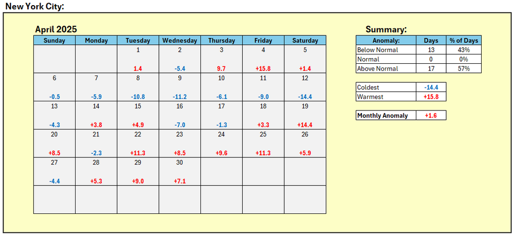
New York City's April Mean Temperature: 55.3° (1.6° above normal).
-
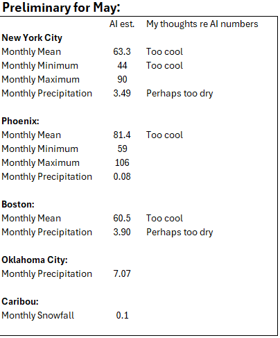
Some AI estimates for May: Final April numbers will be posted tomorrow.
-
It will turn cooler tomorrow before warm air returns to the region ahead of an advancing cold front. The weekend will turn cooler again by Sunday. A wet pattern is likely Sunday through Wednesday. The ENSO Region 1+2 anomaly was -0.3°C and the Region 3.4 anomaly was 0.0°C for the week centered around April 23. For the past six weeks, the ENSO Region 1+2 anomaly has averaged +0.82°C and the ENSO Region 3.4 anomaly has averaged -0.05°C. Neutral ENSO conditions will likely continue through at least early summer. Early indications are that summer 2025 will be warmer than normal in the New York City and Philadelphia areas. The potential exists for a much warmer than normal summer (more than 1° above normal). The SOI was -6.71 today. The preliminary Arctic Oscillation (AO) was +1.619 today.
-
DCA _ NYC _ BOS __ ORD _ ATL _ IAH ___ DEN _ PHX _ SEA 1.7 1.7 1.7 1.3 0.8 0.9 0.2 -0.8 0.2
-
It will turn cooler tomorrow and Thursday before warm air returns to the region ahead of an advancing cold front. The weekend will turn cooler again. The ENSO Region 1+2 anomaly was +0.6°C and the Region 3.4 anomaly was -0.2°C for the week centered around April 16. For the past six weeks, the ENSO Region 1+2 anomaly has averaged +1.08°C and the ENSO Region 3.4 anomaly has averaged 0.00°C. Neutral ENSO conditions will likely continue through at least early summer. Early indications are that summer 2025 will be warmer than normal in the New York City and Philadelphia areas. The potential exists for a much warmer than normal summer (more than 1° above normal). The SOI was -2.31 today. The preliminary Arctic Oscillation (AO) was +0.839 today. Based on sensitivity analysis applied to the latest guidance, there is an implied near 100% probability that New York City will have a warmer than normal April (1991-2020 normal). April will likely finish with a mean temperature near 55.2° (1.5° above normal).
-
Temperatures will rebound into the 70s tomorrow. Tuesday could be the warmest day of the week with the mercury reaching the upper 70s to perhaps 80°. April will end on a warmer than normal note. A cooler air mass will likely move into the region after midweek. The ENSO Region 1+2 anomaly was +0.6°C and the Region 3.4 anomaly was -0.2°C for the week centered around April 16. For the past six weeks, the ENSO Region 1+2 anomaly has averaged +1.08°C and the ENSO Region 3.4 anomaly has averaged 0.00°C. Neutral ENSO conditions will likely continue through at least early summer. Early indications are that summer 2025 will be warmer than normal in the New York City and Philadelphia areas. The potential exists for a much warmer than normal summer (more than 1° above normal). The SOI was -11.47 today. The preliminary Arctic Oscillation (AO) was -0.464 today. Based on sensitivity analysis applied to the latest guidance, there is an implied near 100% probability that New York City will have a warmer than normal April (1991-2020 normal). April will likely finish with a mean temperature near 55.2° (1.5° above normal).
-
Following today's heavy thunderstorm:


-
Some additional showers are possible this evening and tonight. Tomorrow will be the cooler day of the weekend with the temperature struggling to reach 60° in New York City. Temperatures will rebound into the 70s early next week. Tuesday could be the warmest day of the week with the mercury reaching the upper 70s to perhaps 80°. April will end on a warmer than normal note. The ENSO Region 1+2 anomaly was +0.6°C and the Region 3.4 anomaly was -0.2°C for the week centered around April 16. For the past six weeks, the ENSO Region 1+2 anomaly has averaged +1.08°C and the ENSO Region 3.4 anomaly has averaged 0.00°C. Neutral ENSO conditions will likely continue through at least early summer. Early indications are that summer 2025 will be warmer than normal in the New York City and Philadelphia areas. The potential exists for a much warmer than normal summer (more than 1° above normal). The SOI was +2.59 today. The preliminary Arctic Oscillation (AO) was -0.464 today. Based on sensitivity analysis applied to the latest guidance, there is an implied 98% probability that New York City will have a warmer than normal April (1991-2020 normal). April will likely finish with a mean temperature near 55.1° (1.4° above normal).
-
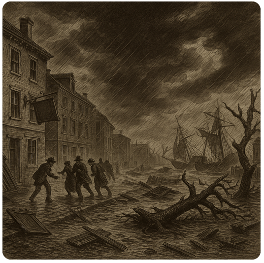
That would be the October 1804 storm. It's a generated sketch.
-
Given the storm track and accounts of the storm, there was no snow in the New York City area. New York City almost certainly experienced heavy wind-driven rain. The wharves along the East River were likely swamped by the storm tide. Streets and buildings in lower Manhattan and along the East River were likely flooded. Many trees were likely uprooted with others having limbs torn down. Ships were driven aground. I asked AI to generate an image of the storm in NYC at the time. Here's what it came up with:
-
Yes. October 4, 1987. https://www.timesunion.com/news/article/freak-snow-storm-was-fall-s-snowy-crippler-16507957.php
-
Remarkably, I am not aware of any earlier measurable snowfalls in NYC even prior to 1869.
-
No. But NYC's earliest measurable snowfall occurred on October 15, 1876 when 0.5" fell. White Plains picked up 3".
-
Back on February 21, I noted: Even worse, when PNA+ ridges grow too strong during the second half of February—pushing to +1.500 or above—they often play the role of a harsh gatekeeper, shutting the door on any chance of a major snowstorm for the rest of the snow season in the New York City area. Winter 2024-2025 will again challenge that "gatekeeper." In the 12 previous cases since 1950, New York City saw no major snowstorms once the PNA reached +1.500 during the February 15-29 period. For me, a "significant" snowstorm is 6" or more and a "major" snowstorm is 10" or more. It's now time to look back to see how things fared following late February's super PNA+ ridge. Unfortunately, there were no snowstorms whatsoever. There was not even a trace of snow. New York City's last snowfall of the 2024-2025 season occurred on February 20th when 0.4" fell.
-
At that time, cold air pools were generally more expansive and more severe than they are today. Storms tapped into the larger pools of cold air. Today, those storms would be mainly or all rain.
-
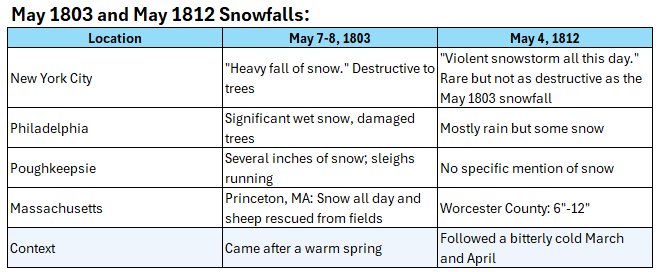
Unfortunately, none of the early newspapers gave any amounts. The earliest maps that I'm aware of go back to 1836. There was an even larger May snowfall in 1803. May 1803 likely saw several inches in New York City and Philadelphia. Most of the snow fell during the nighttime.
-
There very likely was measurable snowfall on May 4, 1812. The newspapers described a violent snowstorm (likely heavy wet snow) that was "among the rarities of the season." The reports noted that the snow fell all day and accumulated.
-
Tomorrow will be another warm day with temperatures topping out in the lower and middle 70s. Showers and thundershowers will likely bring a moderate rainfall tomorrow into Sunday morning. The region will generally see 0.35"-0.85" of rain with some locally higher amounts. Sunday will be the coolest day of the weekend with the temperature struggling to reach 60°. Temperatures will rebound into the 70s early next week. April will end on a warmer than normal note. The ENSO Region 1+2 anomaly was +0.6°C and the Region 3.4 anomaly was -0.2°C for the week centered around April 16. For the past six weeks, the ENSO Region 1+2 anomaly has averaged +1.08°C and the ENSO Region 3.4 anomaly has averaged 0.00°C. Neutral ENSO conditions will likely continue through at least early summer. Early indications are that summer 2025 will be warmer than normal in the New York City and Philadelphia areas. The potential exists for a much warmer than normal summer (more than 1° above normal). The SOI was -1.01 today. The preliminary Arctic Oscillation (AO) was -0.611 today. Based on sensitivity analysis applied to the latest guidance, there is an implied 95% probability that New York City will have a warmer than normal April (1991-2020 normal). April will likely finish with a mean temperature near 55.0° (1.3° above normal).
-
Occasional Thoughts on Climate Change
donsutherland1 replied to donsutherland1's topic in Climate Change
The trade winds and dominant circulations are almost certainly responsible for the cooling of SSTs. -
Occasional Thoughts on Climate Change
donsutherland1 replied to donsutherland1's topic in Climate Change
New Study: Rapid changes in temperature have become more common as the climate has warmed Abstract: Rapid temperature flips are sudden shifts from extreme warm to cold or vice versa–both challenge humans and ecosystems by leaving a very short time to mitigate two contrasting extremes, but are yet to be understood. Here, we provide a global assessment of rapid temperature flips from 1961 to 2100. Warm-to-cold flips favorably follow wetter and cloudier conditions, while cold-to-warm flips exhibit an opposite feature. Of the global areas defined by the Intergovernmental Panel on Climate Change, over 60% have experienced more frequent, intense, and rapid flips since 1961, and this trend will expand to most areas in the future. During 2071–2100 under SSP5-8.5, we detect increases of 6.73–8.03% in flip frequency (relative to 1961–1990), 7.16–7.32% increases in intensity, and 2.47–3.24% decreases in transition duration. Global population exposure will increase over onefold, which is exacerbated in low-income countries (4.08–6.49 times above the global average). Our findings underscore the urgency to understand and mitigate the accelerating hazard flips under global warming. https://www.nature.com/articles/s41467-025-58544-5 -
Today was another warm day before the sea breeze pushed in. Temperatures rose into the 70s across much of the area. The warm weather will continue through the week. It will turn somewhat cooler but remain mild during the weekend. A moderate rainfall is possible during the weekend. Sunday will also be the coolest day with readings topping out in the lower and middle 60s. Temperatures will rebound into the 70s early next week. The ENSO Region 1+2 anomaly was +0.6°C and the Region 3.4 anomaly was -0.2°C for the week centered around April 16. For the past six weeks, the ENSO Region 1+2 anomaly has averaged +1.08°C and the ENSO Region 3.4 anomaly has averaged 0.00°C. Neutral ENSO conditions will likely continue through at least early summer. Early indications are that summer 2025 will be warmer than normal in the New York City and Philadelphia areas. The potential exists for a much warmer than normal summer (more than 1° above normal). The SOI was -5.91 today. The preliminary Arctic Oscillation (AO) was -0.666 today. Based on sensitivity analysis applied to the latest guidance, there is an implied 92% probability that New York City will have a warmer than normal April (1991-2020 normal). April will likely finish with a mean temperature near 55.0° (1.3° above normal).