donsutherland1
-
Posts
23,988 -
Joined
Content Type
Profiles
Blogs
Forums
American Weather
Media Demo
Store
Gallery
Everything posted by donsutherland1
-
September 2025 OBS-Discussion centered NYC subforum
donsutherland1 replied to wdrag's topic in New York City Metro
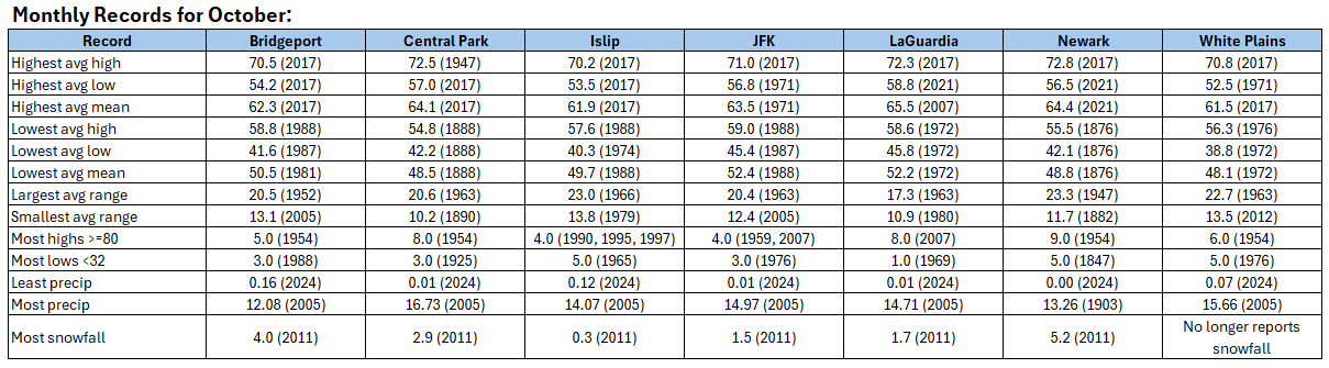
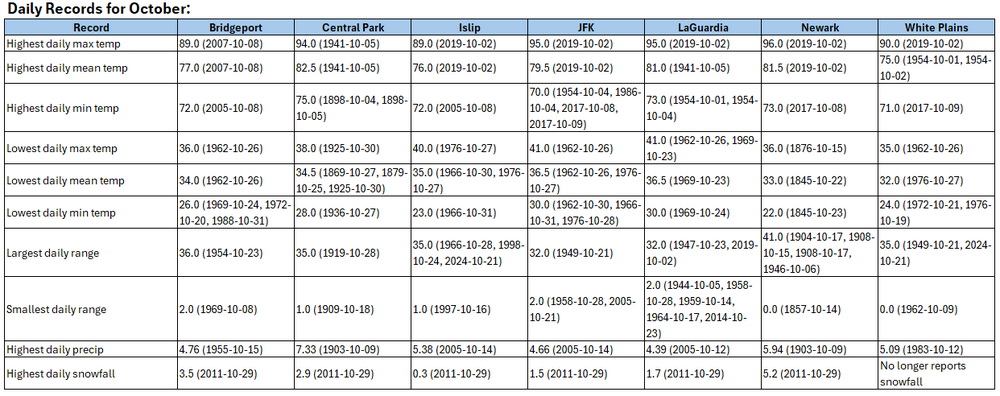
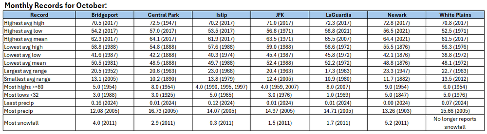
Were that to happen, that would set a new record. The record is 72.5° in 1947. -
September 2025 OBS-Discussion centered NYC subforum
donsutherland1 replied to wdrag's topic in New York City Metro
Despite the wet start during the first week of September, consistent with most cases where there was no rainfall during the last 10 days of August, September 2025 will wind up drier than normal in New York City.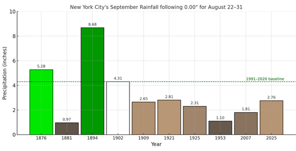
-
September 2025 OBS-Discussion centered NYC subforum
donsutherland1 replied to wdrag's topic in New York City Metro
The 1891 data is largely missing for Newark not NYC. September 1–15, 1891: 70.1° September 16–30, 1891: 74.0° October 1891: 54.9° -
Winter cancelled/uncancelled banter 25/26
donsutherland1 replied to Rjay's topic in New York City Metro
Sensationalist headlines do create problems, as they draw attention from the actual science. There's a big difference from, let's say, asserting that the Arctic could be ice free by 2030 when a single ensemble member shows the possibility of an ice free (< 1 million km2) summer by 2030 and most of the members show 2040-2050 for the first such summer. "Ice free" Arctic implies all seasons. 2030 focuses on a single ensemble member. The overwhelming model consensus is 2040 or later for the first ice-free summer. When drafting legislation, those seeking remedies often try to attach their desired causes to other legislation to improve prospects for those causes. There are some legitimate climate justice issues e.g., location of refineries in predominantly minority neighborhoods where large cancer clusters or significant particulate pollution exists. However, using the legislation to advocate for sweeping social reforms e.g., wage reforms, that go far beyond such issues, has no connection to the science. In part, this is true. However, science operates on the rejection of null hypotheses. Very high confidence (usually 95% or above) is needed to reject a hypothesis. That's why it took so long for the IPCC to recognize that anthropogenic greenhouse gas emissions had been the dominant cause of warming since the mid-20th century. Moreover, the laws of physics responsible were understood since the mid-19th century. The idea that a doubling of CO2 would lead to a large increase in temperature was understood by the turn of the 20th century. Yet, because internal variability is large, the science had to wait until the climate change signal was unmistakably apparent. Further, while caution can delay the onset of aggressive action, bad faith actors and weak leaders do a lot more to thwart problem-solving. Today, the reality that the world is warming and that anthropogenic greenhouse gas emissions are driving the warming is unequivocal. Yet, key actors in society have doubled down on a desperate bid to preserve the status quo. In doing so, today's political leaders have ignored the bolder precedent set by their predecessors who tackled both the acid rain and ozone depletion issues. Then again, perhaps because Cold War era leaders had to tackle or manage existential issues far more complex and larger than those that confront today's leaders, it's probably little surprise that they were willing and able to tackle acid rain and ozone depletion without finding excuses for delay, much less denying the problems altogether. In the end, the scientists have done their job and exceptionally well. Their findings have stood the test of time. Political and business leaders have not done theirs. Humanity has substantial agency to act today and humanity has enjoyed the luxury of a truly substantial amount of time to address the problem of climate change in a very gradual fashion. Unfortunately, humanity has squandered a significant and growing portion of that time. Any protests down the road that little could have been done to avert 1.5°C warming over pre-industrial levels (which may already have been reached) lack merit. In the future, impacts such as those from a rising sea level that begins to claim neighborhoods or acidification of oceans that reduces harvests of fish, will not be the unavoidable tragedies that humanity will spin. They will be the tragedies that one or more generation of impotent and short-sighted leaders chose not to prevent. -
September 2025 OBS-Discussion centered NYC subforum
donsutherland1 replied to wdrag's topic in New York City Metro
I suspect that public understanding is undermined more by social media influencers, such as the one highlighted in the below example. These influencers typically have no climate expertise and have no climate research record as per literature searches, but regularly and confidently contradict the literature, much of which they have never read much less understand. Today, social media is increasingly a growing number of people's first choice for information. Mainstream science is actually quite cautious in its pronouncements and often notes caveats e.g., the role of internal variability. Nevertheless, bad faith social media influencers misrepresent and distort those findings to their audiences, most of whom have no inclination to actually go to the literature for the facts.
-
September 2025 OBS-Discussion centered NYC subforum
donsutherland1 replied to wdrag's topic in New York City Metro
Around September 18th. -
September 2025 OBS-Discussion centered NYC subforum
donsutherland1 replied to wdrag's topic in New York City Metro
Islip reached 82° today. That was its fifth 80° or above high during the second half of September. The last time there were at least as many such days during the second half of September was in 2017 when there were eight such days. The five days is also tied with 1998 and 2016 for the fifth highest number on record for the second half of September. -
September 2025 OBS-Discussion centered NYC subforum
donsutherland1 replied to wdrag's topic in New York City Metro
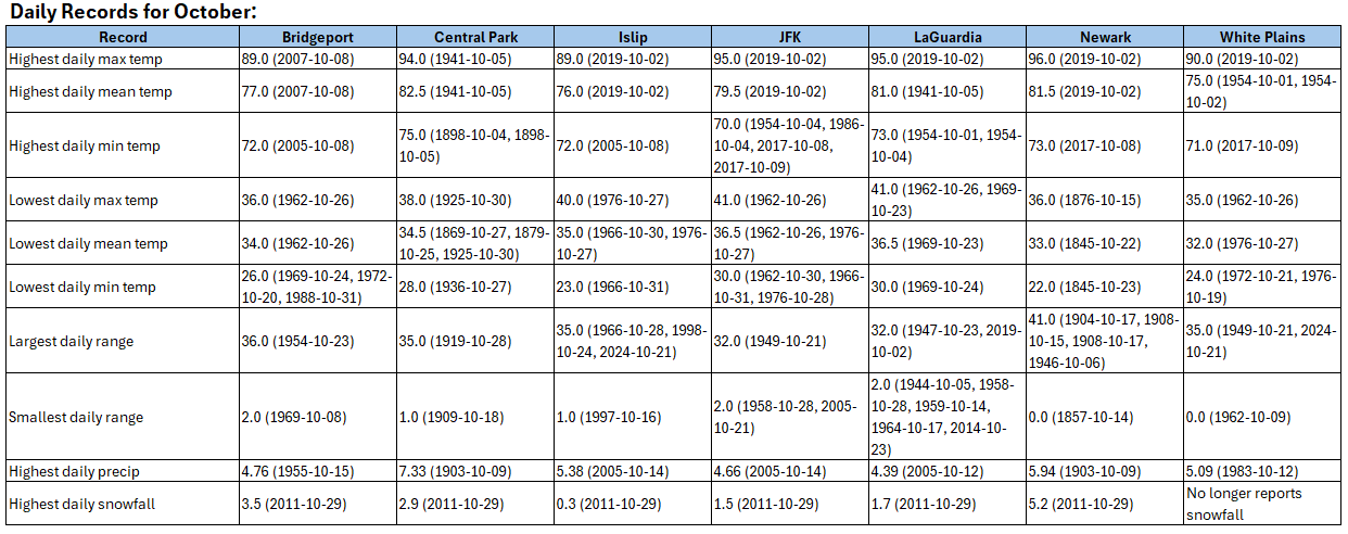
As of 4:30 pm, some showers were working their way into southern New Jersey. Cape May was receiving light rain. Some of these showers could each the New York City area tonight. Showers and light rain are possible tonight into tomorrow. Rainfall amounts should be light. Above normal temperatures will continue through the remainder of September. The start of October could see the arrival of the coolest air mass so far this season, but temperatures will likely quickly moderate. The guidance and historical experience following a second half September mean temperature of 70° or above suggest that October will be warmer than normal in the New York City area. The two most recent Octobers with a cooler than normal first half like 2025 and a second half with a mean temperature of 70° or above were: 2017 (October mean temperature: 64.1° and October 2019: October mean temperature 59.9°). The probability that TD9 will approach the South Carolina coast but then turn out to sea from there is increasing on account of the expected Fujiwhara interaction with the stronger Humberto. That is now the most likely outcome, even as there remains a possibility of landfall. Even without landfall, the storm would bring periods of heavy rain, gusty winds, and pounding surf to coastal areas. The ENSO Region 1+2 anomaly was 0.0°C and the Region 3.4 anomaly was -0.4°C for the week centered around September 17. For the past six weeks, the ENSO Region 1+2 anomaly has averaged -0.03°C and the ENSO Region 3.4 anomaly has averaged -0.38°C. La Niña conditions will likely develop during mid- or late-autumn. The SOI was +2.85 today. The preliminary Arctic Oscillation (AO) was +0.807 today. Based on sensitivity analysis applied to the latest guidance, there is an implied near 99% probability that New York City will have a warmer than normal September (1991-2020 normal). September will likely finish with a mean temperature near 70.3° (1.1° above normal). Supplemental Information: The projected mean would be 2.3° above the 1981-2010 normal monthly value. -
Missing dates. I have redone the file. I had forgotten to exclude months with missing days.
-
September 2025 OBS-Discussion centered NYC subforum
donsutherland1 replied to wdrag's topic in New York City Metro
Sorry, I pasted from the table early in this thread and accidentally overlooked my note. There were missing days. Note: The highest average maximum temperature at Newark for a September that is missing no daily records is 83.3°, which was set in 2005. -
September 2025 OBS-Discussion centered NYC subforum
donsutherland1 replied to wdrag's topic in New York City Metro
1983 actually does not hold the record for mean high during September, but does hold the record for most 90° or above days at a number of local sites.

-
-
2025-2026 ENSO
donsutherland1 replied to 40/70 Benchmark's topic in Weather Forecasting and Discussion
The New York City area can still see both big snowstorms and snowy winters and that will be the case for decades to come even if/as seasonal snowfall declines. -
2025-2026 ENSO
donsutherland1 replied to 40/70 Benchmark's topic in Weather Forecasting and Discussion
It has a very weak correlation. I don't think it's of much predictive value. It should also be noted that some more recent research suggests that it is lower September-October Siberian snow cover that translates into a weaker polar vortex during late winter and early spring while increased Siberian snow cover (September–October) leads to a stronger polar vortex in late winter and early spring. For example: The reduced snow cover benefits a deceleration of the circumpolar westerlies, the sea ice loss in the Barents-Kara Seas, the positive Pacific-North American pattern, and the negative Aleutian-Icelandic Low Seesaw pattern, which amplify the intensity of planetary waves propagating upward into the stratosphere. The enhanced planetary waves are characterized by the stratospheric dipole-like pattern during the preceding October and December and contribute to the continuous weakening of the polar vortex from January to March. https://www.sciencedirect.com/science/article/pii/S0169809524002898 -
This paper likely explains why they are leveraging AI: https://alixsoliman.com/wp-content/uploads/2025/01/nature_deepmind-weather-ai_in-print_alix-soliman.pdf
-
September 2025 OBS-Discussion centered NYC subforum
donsutherland1 replied to wdrag's topic in New York City Metro
The guidance still has the showers/light rain. Whether they're correct remains to be seen. -
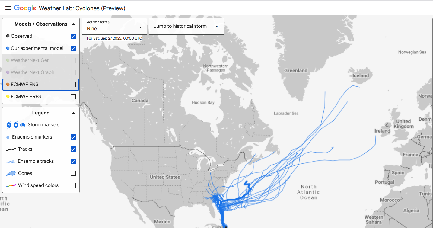
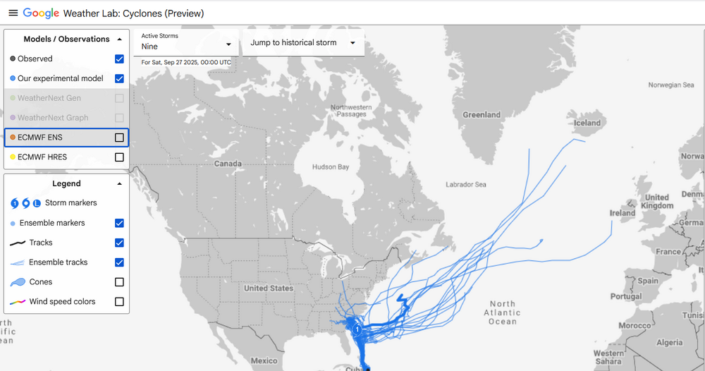
With the NHC now referring to Google DeepMind in some of its discussions, below is the latest Google DeepMind output for PTC9 at closest approach on the ensemble mean track:
-
September 2025 OBS-Discussion centered NYC subforum
donsutherland1 replied to wdrag's topic in New York City Metro
My thoughts on what will become Imelda, while recognizing that there is still some uncertainty: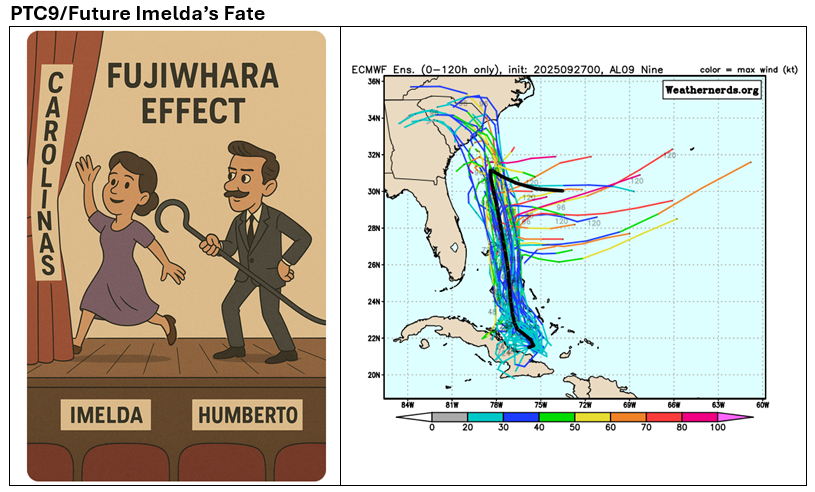
-
Courtesy of the Fujiwhara Effect, my thinking is that the stronger Humberto will pull what will become Imelda away from the coastline before U.S. landfall can occur and before ridging can rebuild overhead to break down the steering currents and later redirect Imelda toward U.S. landfall. The Bahamas and possibly Bermuda will need to closely monitor the developing tropical cyclone. There remains a degree of uncertainty.
-
September 2025 OBS-Discussion centered NYC subforum
donsutherland1 replied to wdrag's topic in New York City Metro
Yes. That’s what the NWS reported. -
September 2025 OBS-Discussion centered NYC subforum
donsutherland1 replied to wdrag's topic in New York City Metro
153rd with a standard deviation of 9.16 degrees. Here's a comparison of 1983 with 2023 (which still ranks second through yesterday):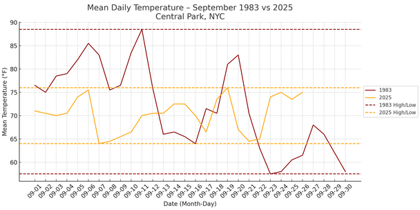
-
September 2025 OBS-Discussion centered NYC subforum
donsutherland1 replied to wdrag's topic in New York City Metro
It was. Islip also tied its daily record of 85° from 1970. -
September 2025 OBS-Discussion centered NYC subforum
donsutherland1 replied to wdrag's topic in New York City Metro
Rainfall amounts in the New York City area were generally less than the 0.50"-1.50" forecast amounts. There was a stripe of heavier rainfall in parts of Connecticut. Storm total amounts included: Hartford: 1.72" Islip: 0.30" New Haven: 1.34" New York City-Central Park: 0.35" New York City-JFK Airport: 1.38" New York City-LaGuardia Airport: 0.33" Newark: 0.17" Storrs: 2.76" White Plains: 0.47" As a result, New York City is on track to finish with rainfall that is below the 4.31" monthly normal value for September. Almost as if to add insult to injury to the dry New York City area, in the past hour, Phoenix has picked up 1.09" of rain, along with winds gusting to 56 mph. The 1.11" so far today is its biggest rainstorm since October 13, 2018. Above normal temperatures will continue through the remainder of September. Another round of showers is possible Saturday night into Sunday. A significant rainfall is unlikely. The guidance and historical experience following a second half September mean temperature of 70° or above suggest that October will be warmer than normal in the New York City area. The two most recent Octobers with a cooler than normal first half like 2025 and a second half with a mean temperature of 70° or above were: 2017 (October mean temperature: 64.1° and October 2019: October mean temperature 59.9°). The extent of ridging to the north and interaction between the Humberto and Invest. 94 could ultimately determine whether Invest. 94 poses an eventual threat to a portion of the Southeast or stays out to sea. The potential Fujiwhara interaction would be unusual for the Atlantic basin. Typically, if the stronger system is to the right or east of the weaker one (possibly Invest. 94 as per most of the guidance at present), the stronger system will tend to deflect the weaker one northward and eastward sooner than might otherwise be the case. If both systems are of similar strength, they can rotate counterclockwise around a midpoint roughly between the centers of the two storms as they move along the steering flow. Two plausible scenarios are landfall along the South Carolina coast or a sharp turn out to sea after an approach toward the coastline. For now, tropics bear watching for the Southeast. The ENSO Region 1+2 anomaly was 0.0°C and the Region 3.4 anomaly was -0.4°C for the week centered around September 17. For the past six weeks, the ENSO Region 1+2 anomaly has averaged -0.03°C and the ENSO Region 3.4 anomaly has averaged -0.38°C. La Niña conditions will likely develop during mid- or late-autumn. The SOI was +9.81 today. The preliminary Arctic Oscillation (AO) was +1.341 today. Based on sensitivity analysis applied to the latest guidance, there is an implied near 86% probability that New York City will have a warmer than normal September (1991-2020 normal). September will likely finish with a mean temperature near 70.1° (0.9° above normal). Supplemental Information: The projected mean would be 2.1° above the 1981-2010 normal monthly value. -
September 2025 OBS-Discussion centered NYC subforum
donsutherland1 replied to wdrag's topic in New York City Metro
Newark has reached 86°. That's the fourth time it has reached 86° or above during the second half of September. The last time there were at least four such days during the second half of September was 2019 when there were five such days. -
September 2025 OBS-Discussion centered NYC subforum
donsutherland1 replied to wdrag's topic in New York City Metro
Westhampton reached 81° this afternoon. That broke the daily record of 80° from 1961.