donsutherland1
-
Posts
23,988 -
Joined
Content Type
Profiles
Blogs
Forums
American Weather
Media Demo
Store
Gallery
Everything posted by donsutherland1
-
Today got off to another chilly start. Many areas outside New York City again saw the temperature start out in the 40s with colder spots recording 30s. Low temperatures included: Bridgeport: 48° Danbury: 41° Islip: 47° Montgomery: 35° New Haven: 45° New York City-Central Park: 54° New York City-JFK Airport: 51° New York City-LaGuardia Airport: 57° Newark: 51° Poughkeepsie: 39° Sussex: 38° Westhampton: 35° White Plains: 47° In parts of the Upper Midwest and Northern Plains, daily and monthly high temperature records were set. Green Bay (88°) and Rapid City (96°) tied their October monthly records. Philip, SD reached 98°, breaking its October monthly record of 97° for October 1, 1953. The New York City area will be on the fringes of this exceptionally warm air mass this weekend into early next week. A warm weekend lies ahead. Highs will generally reach the upper 70s to lower 80s. The warm weather will continue early next week. Another strong cold front will likely cross the region around midweek. The frontal passage will likely bring some showers or thundershowers. A shot of much cooler air will follow. The ENSO Region 1+2 anomaly was -0.1°C and the Region 3.4 anomaly was -0.5°C for the week centered around September 24. For the past six weeks, the ENSO Region 1+2 anomaly has averaged -0.12°C and the ENSO Region 3.4 anomaly has averaged -0.42°C. La Niña conditions will likely develop during mid- or late-autumn. The SOI was +5.48 today. The preliminary Arctic Oscillation (AO) was +0.374 today.
-
I believe he's describing the declining number of snow days.
-
2025-2026 ENSO
donsutherland1 replied to 40/70 Benchmark's topic in Weather Forecasting and Discussion
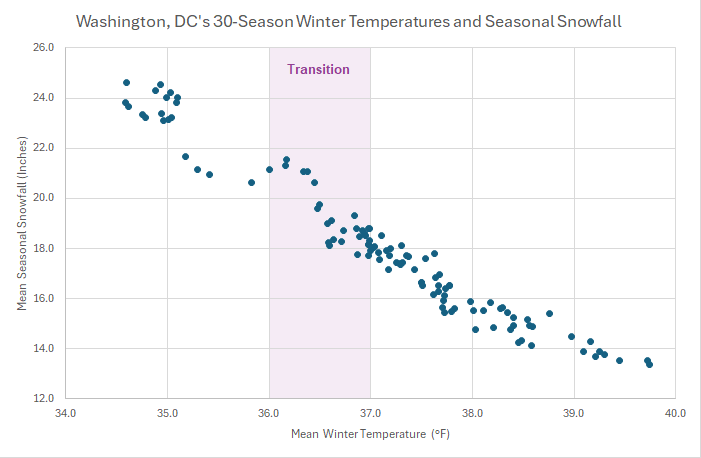
Once the winter mean temperature reaches 34.0° or above, the frequency of 50" or above snow seasons largely but not completely disappears. Washington, DC's 35.8° (2009-10) is the single case above 35.0° among all of the listed locations. For Central Park and also additional locations:
-
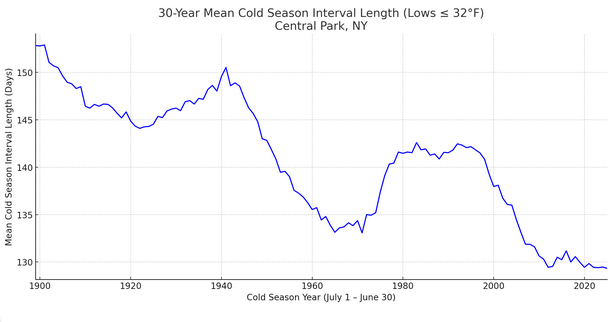
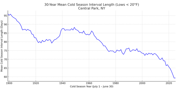
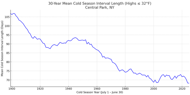
Yes, the cold season is being compressed. Lows of 32° or below: Lows < 20°: Highs of 32° or below:
-
It’s rare in the lower elevations and about a once-every-five-year occurrence in the mountains. Belgrade’s first snowfall is typically November 30 (earliest: October 7, 1897: Trace).
-
Highly unlikely. Since 1869, only 1891 (October 5) and 2002 (October 7) had the last 70 or above high on or before October 7 at Central Park. Records go back to 1869.
-
2025-2026 ENSO
donsutherland1 replied to 40/70 Benchmark's topic in Weather Forecasting and Discussion
That's not likely to happen for decades. Even if Baltimore sees no snow from winter 2025-26 through 2039-40 (virtually certain not to be the case), the 30-season moving average would be 7.2" vs. the current 18.9" through 2024-2025. Through at least mid-century, there will likely be some snowy winters even as the long-term snowfall average generally declines. Although Washington, DC has likely transitioned into a lower snowfall regime and Baltimore to NYC are likely in the early stages of such a transition, the idea that snowy winters are a thing of the past is not likely to hold true through at least mid-century, if not longer. Such winters will likely grow less frequent as warming continues, but they won't disappear altogether. That outcome might not occur until global temperatures are 3°C above pre-industrial levels, which appears likely in the vicinity of 2100 (maybe a little earlier if some of the positive feedbacks e.g., Arctic cloud changes, etc. lead to a further acceleration in warming). The transition for Baltimore, Philadelphia, and New York City will likely be noisier (bigger rise, greater volatility) and perhaps a bit more extended e.g.. to 37.5° mean winter temperatures than it was for Washington, DC due to their closer proximity to cold source regions.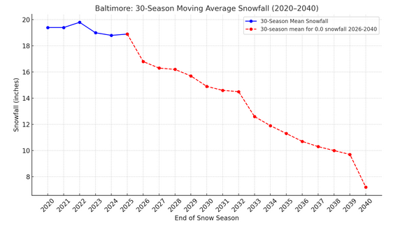
-
Unfortunately, the later research has suggested that a higher Siberian Snow Advance Index (SAI) is correlated with a positive AO. The research notes that the early inverse relationship found by Cohen et al., was an exception, not a rule. Excerpts: The running decadal correlations between the SAI_OCT and AO and SAI_NOV and AO are shown in Fig. 7d and e, respectively. In the former, there are significantly more positive than negative values (Table 3), suggesting that the period of strong positive (negative as defined here) correlations that occurred in the 1990s and 2000s, as described by Cohen and Jones (2011), was a rather exceptional event, as previously noted by Peings et al. (2013). Indeed, the frequency of decades with significant SCA_OCT–AO correlations of either sign are not significant. In addition to the recent period in the 2000s, Fig. 7d reveals a period of significant negative correlations centred in the 1840s, also present in the 21-year data (Fig. S4d). Finally, the ERA5 data reveal that the recent period of the statistically significant negative relationship between SAI_OCT and the AO has ended: the most recent decades have positive r values.
-
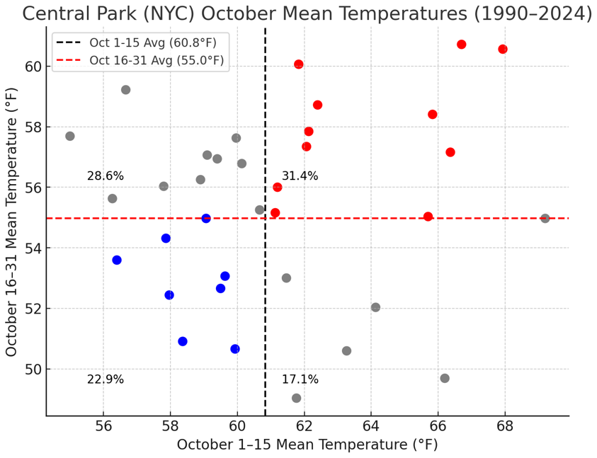
Here's how the second half of October has fared after a warmer or colder than normal first half since 1990.
-
Winter cancelled/uncancelled banter 25/26
donsutherland1 replied to Rjay's topic in New York City Metro
It wouldn't take much in terms of snowfall. I doubt that it will be as cold as last winter. My thinking early on for NYC: +1.0° to +1.5° and 15"-25" snowfall. -
The region experienced its coolest lows so far this season overnight. Low temperatures included: Binghamton: 39° Bridgeport: 50° Caldwell: 47° Danbury: 39° Islip: 50° Montgomery: 36° New Haven: 47° New York City-Central Park: 53° New York City-JFK Airport: 52° New York City-LaGuardia Airport: 54° Newark: 52° Poughkeepsie: 36° Sussex: 37° Westhampton: 50° White Plains: 48° Temperatures will quickly moderate tomorrow, rising to above normal levels by the weekend as an air mass that will challenge or break records in parts of the Upper Midwest moves eastward. Already, parts of South Dakota saw highs reach 90° or above. A warm weekend lies ahead. Highs will generally reach the upper 70s to lower 80s. The warm weather will continue early next week. The ENSO Region 1+2 anomaly was -0.1°C and the Region 3.4 anomaly was -0.5°C for the week centered around September 24. For the past six weeks, the ENSO Region 1+2 anomaly has averaged -0.12°C and the ENSO Region 3.4 anomaly has averaged -0.42°C. La Niña conditions will likely develop during mid- or late-autumn. The SOI was +15.60 today. The preliminary Arctic Oscillation (AO) was -0.011 today.
-
2025-2026 ENSO
donsutherland1 replied to 40/70 Benchmark's topic in Weather Forecasting and Discussion
I agree. I suspect that's part of the reason we saw a very warm end to September across much of the CONUS. -
Occasional Thoughts on Climate Change
donsutherland1 replied to donsutherland1's topic in Climate Change
IMO, until global shocks become truly synchronized, the prevailing inertia is likely to persist. Psychologically, shifting from decision avoidance to proactive problem-solving is extraordinarily difficult for leaders who lack courage and foresight, especially when doing so requires sacrificing the comforts of the status quo. The danger, as the literature suggests, is that by the time globally synchronized harvest failures and cascading disasters emerge, warming will already have advanced to levels where damage is locked in and far worse than it might otherwise have been. Some studies project once-per-decade synchronized shocks around 2 °C of warming. Yet even at that scale, such events could still be dismissed as “bad luck,” painful in human and economic terms but ultimately normalized within existing systems of risk. Only when these shocks become unmistakably regular, perhaps near 3 °C warming, will denial and delay collapse under the weight of recurring crises. Human societies have always normalized risk until it is unavoidable (Typhoon Tip's linkage to human nature is on the mark), and climate change has been no exception. People tend to discount future dangers, cling to established routines, and resist costly change until shocks become both visible, substantial, and persistent. Until synchronized failures shift from rare to recurrent, most governments and industries are likely to stick with the status quo, effectively sustaining the global geoengineering project of filling the atmosphere with carbon. In doing so, they are constructing a future marked by predictable and frequent catastrophes. When that moment arrives, excuses will abound, but the truth will remain: these crises were foreseeable and foreseen. Even more importantly, they were preventable. Today, humanity possesses both the knowledge and the means to act. Yet, it chooses not to do so, ensuring its investment in inaction will yield tomorrow's challenges and catastrophes. -
The Balkans will have an unusuallly early and strong shot of cold and snow.
-
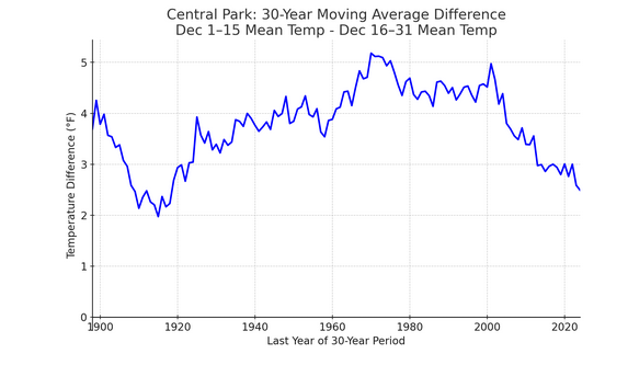
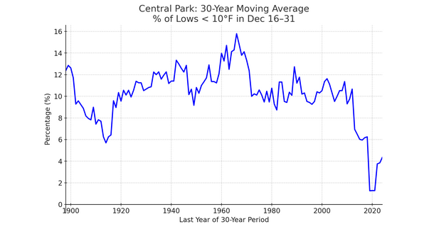
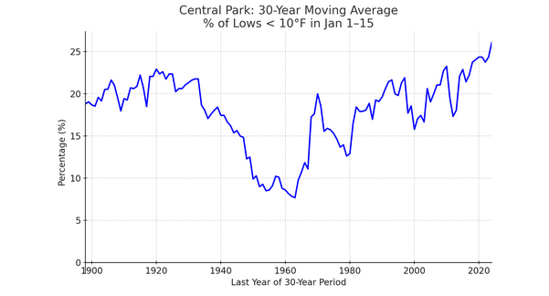
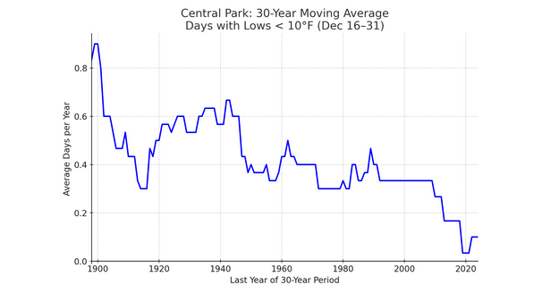
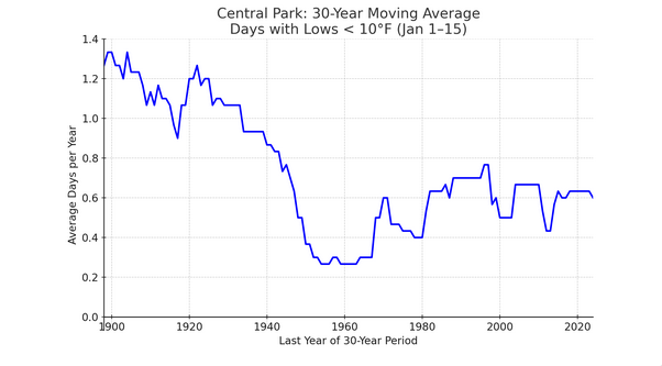
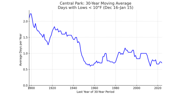
I just went back to the whole climate record. This isn't the first time that it's happened. I suspect that the current narrowing has a climate component in addition to a cyclical/internal variability component. My hypothesis about a climate component's being involved is based on the shrinking deep cold pool resulting in warming winters and a delay and a shortening duration of the coldest outbreaks, in general. The result is that the frequency of extreme cold is falling and the distribution of extreme cold is being pushed into the first half of January. Prior to 1990, about 12.1% of NYC's single-digit or colder lows occurred during December 16-31. Since 1990, that figure has fallen to 5.0%. On a 30-year rolling basis, the December 16-31 frequency of such cold is lower than during the earlier period where the temperature difference between December 1-15 and December 16-31 narrowed substantially. The frequency of such cold has declined markedly for the December 16-31 period. Hence, there appears to be a climate component involved this time around with the narrowing of the temperature difference between the first and second halves of December. Distribution of Lows < 10°: Frequency of Lows < 10°:
-
The change has been dramatic. During 1961-1990, the second half of December was 4.3 degrees colder than the first half in NYC. During 1991-2020, it was 3.0 degrees colder and since 2000, it is just 1.9 degrees colder during the second half of December.
-
I agree.
-
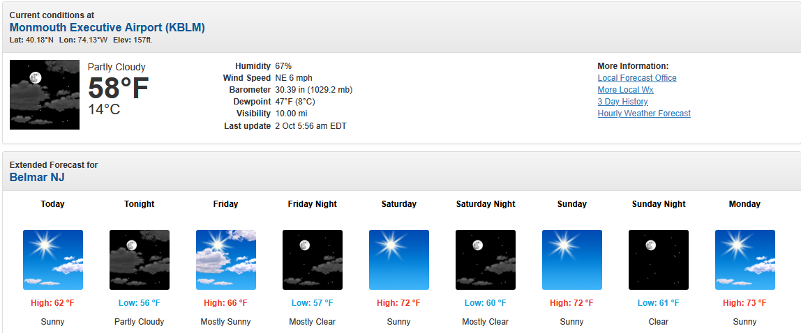
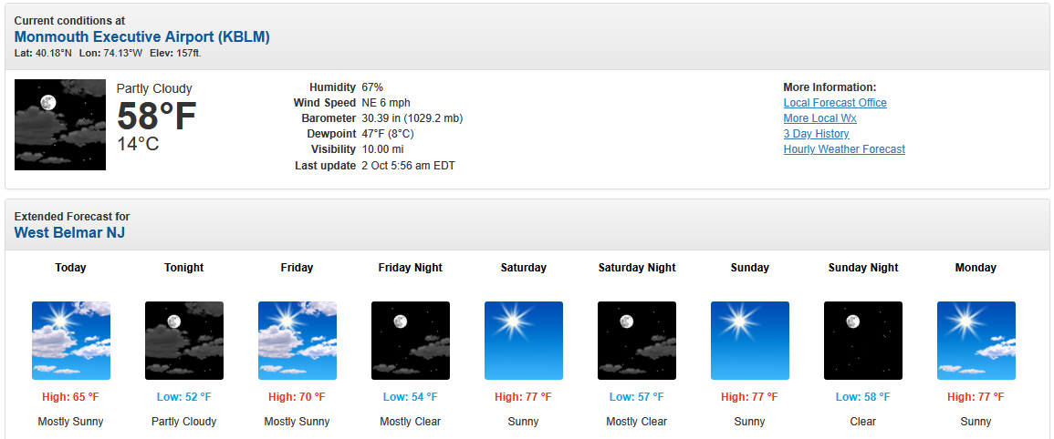
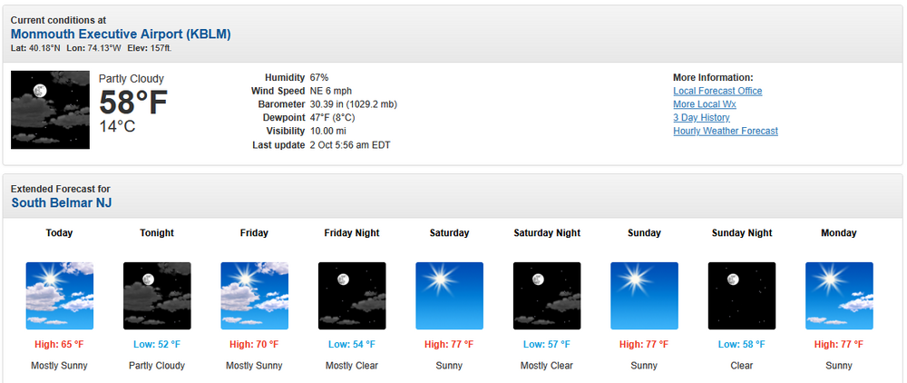
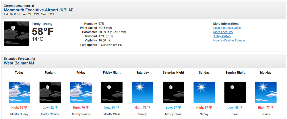
The forecast is inconsistent with the AFD, which states: .SHORT TERM /FRIDAY NIGHT THROUGH SATURDAY NIGHT/... Our expansive high pressure system remains the dominant weather feature through the short term period. This keeps the tranquil weather pattern going into the weekend. Friday night and Saturday night look mostly clear with minimal cloud cover. During the day Saturday, it is a mostly sunny day. Highs on Saturday will be in the mid to upper 70s. The NBM has consistently shown highs of 77°-79° for Saturday and Sunday. Moreover, if one uses "South Belmar" (Lake Como) and "West Belmar," one gets the warmer forecast. Belmar: South Belmar: West Belmar:

-
October commenced with the arrival of the coolest air mass so far this season. After another very cool day tomorrow, temperatures will quickly moderate, rising to above normal levels by the weekend as an air mass that will challenge or break records in parts of the Upper Midwest moves eastward. Tomorrow will be the coolest day. High temperatures will reach only the middle 60s tomorrow. New York City will see the low temperature bottom out in the lower 50s. Outside the City, widespread 40s are likely. A few of the colder locations could see the temperature bottom out in the 30s. A rapid warmup will commence on Friday and a warm weekend lies ahead. The ENSO Region 1+2 anomaly was -0.1°C and the Region 3.4 anomaly was -0.5°C for the week centered around September 24. For the past six weeks, the ENSO Region 1+2 anomaly has averaged -0.12°C and the ENSO Region 3.4 anomaly has averaged -0.42°C. La Niña conditions will likely develop during mid- or late-autumn. The SOI was +13.60 today. The preliminary Arctic Oscillation (AO) was -0.387 today.
-
Occasional Thoughts on Climate Change
donsutherland1 replied to donsutherland1's topic in Climate Change
Unfortunately, that appears to be the de facto strategy. The issue isn't one of technology (the technology already exists and is improving), costs (renewable energy is less expensive than fossil fuels), resources for investment (society has proved capable of mobilizing enormous sums of money at rapid speed), or lack of time (the problem has been known for decades allowing for a very gradual transition), but one of a decided and purposeful lack of urgency. A book published last year (Wiegandt 2024) that sketches out, in part, a world that is 3°C warmer than the pre-industrial world (likely scenario by 2100 on the current path), highlights how human societies mobilize when they perceive that there are real, grave, and urgent problems and when they don't. Unfortunately, the issue of climate change falls into the latter example as far as human society is concerned, even noting the dramatic backward developments in the United States. The book's editor wrote: In such a future world, we will have to deal with a radicalization of weather patterns and with temperatures that will be as much as 6 degrees higher on average over land areas. Such a transformation will have grave effects on global agriculture, massively damage global infrastructure, and significantly impair or even destroy large ecosystems... I would like to recall that governments mobilized trillions of U.S. dollars, overnight, as it were, both in 2008 to deal with the world financial crisis and in 2020 in the wake of the rampant Corona pandemic! We must realize that global warming poses an incomparably greater challenge. Given the editor's observation and lack of action today, once irreversible outcomes are realized e.g., from rising sea level, the greatest tragedy won't be the loss of valuable real estate that is reclaimed by a rising ocean and the social and economic dislocations it causes, bad as they might be. The greatest tragedy will be that the problem was fully avoidable had today's generation of political leaders possessed the courage and foresight to act. They could have prevented the outcome. Instead, they chose to subject future generations, including today's youth, to the growing consequences of a warmer world. A return to the mid-Pliocene almost certainly won't bring about a tropical Paradise on Earth. -
Occasional Thoughts on Climate Change
donsutherland1 replied to donsutherland1's topic in Climate Change
It was the wettest monsoon season in Phoenix since 2021 and biggest one- and two-day rainfalls since October 2018. -
September 2025 OBS-Discussion centered NYC subforum
donsutherland1 replied to wdrag's topic in New York City Metro
Highest Percentage of Days with 10" or More Snowfall): 1869-2024: February 4-10: 0.8% of days 1991-2020: January 20-26: 1.4% of days -
September 2025 OBS-Discussion centered NYC subforum
donsutherland1 replied to wdrag's topic in New York City Metro
It depends on the timeframe one is using and how one defines snowiest week. Select data for Central Park: Snowiest Week (Based on Mean Daily Snowfall): 1869-2024: February 7-13: 0.4" per day 1991-2020: January 21-27: 0.6" per day Snowiest Week (Based on the Percentage of Days with Measurable Snowfall): 1869-2024: January 27-February 2: 16.1% 1991-2020: January 25-31: 15.7% Snowiest Week (Based on the Percentage of Days with 1" or More Snowfall): 1869-2024: February 1-7: 9.0% 1991-2020: January 21-27: 10.5% -
First week of October looks very dry. A frontal passage might bring some rain early in the second week of the month, but a lot can still change by that time.
-
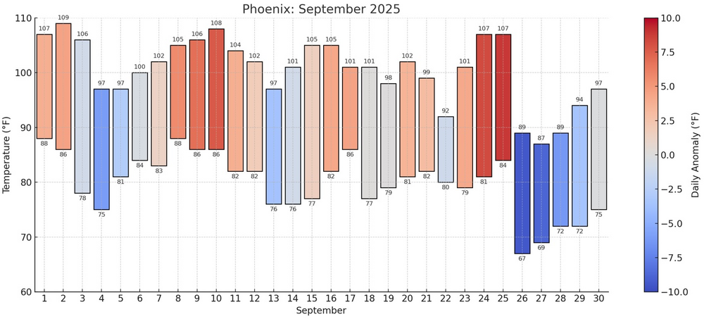
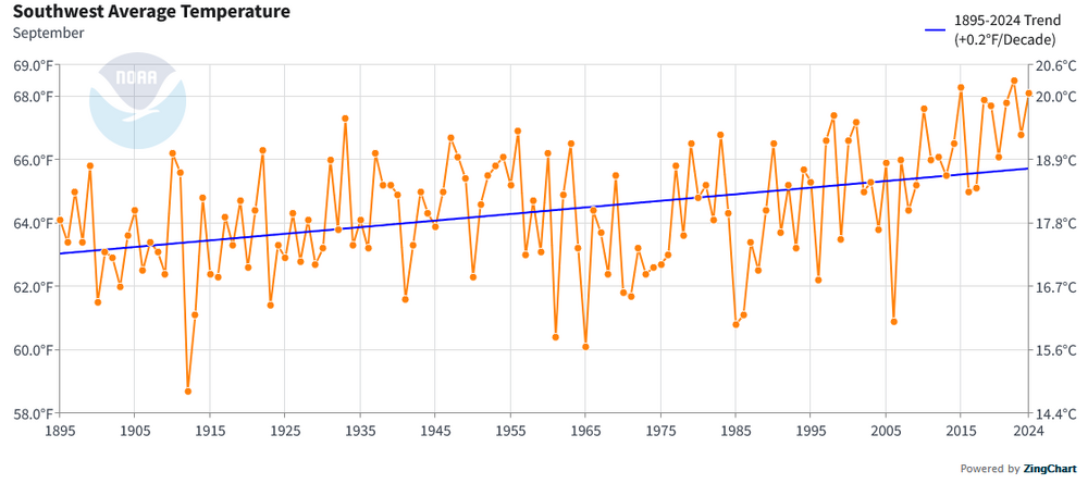
Occasional Thoughts on Climate Change
donsutherland1 replied to donsutherland1's topic in Climate Change
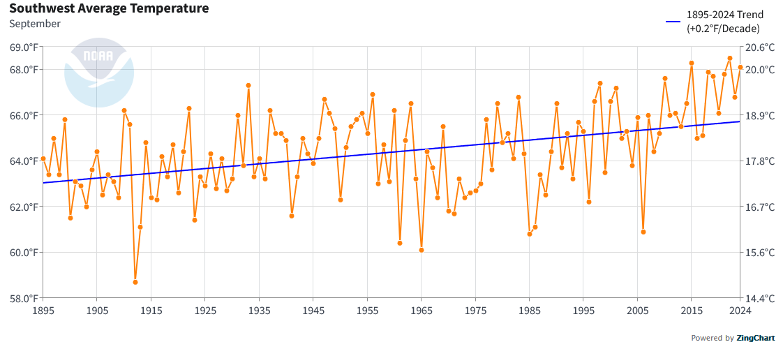
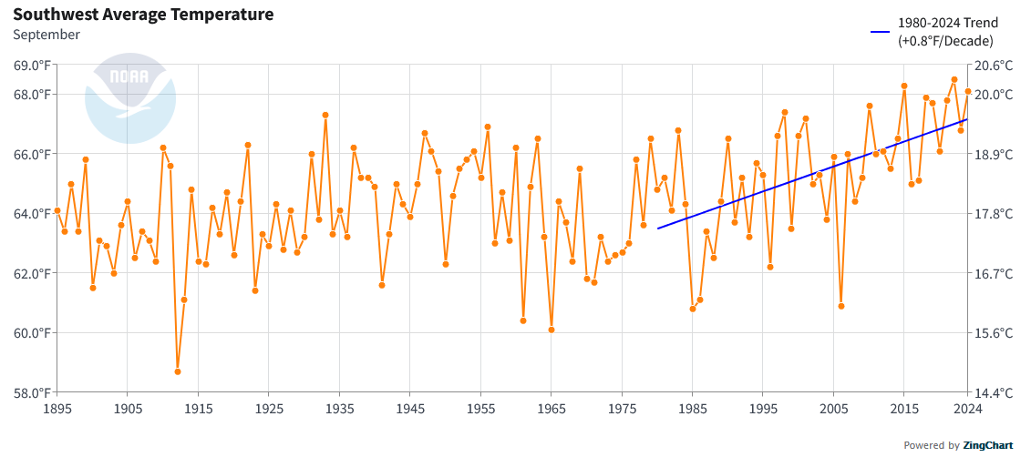
September 2025 in Phoenix marked the fourth consecutive year with a monthly mean temperature at or above 90°, a milestone never before observed in Phoenix's historical climate record which goes back to 1895. This persistent late-summer heat is consistent with the broader impacts of climate change, which is driving rising temperatures, more frequent and intense heatwaves, and shifts in seasonal patterns across the Southwest. Although internal variability influences any single month's weather, the sustained nature of recent September heat underscores a long-term warming trend fueled by anthropogenic greenhouse gas emissions. September also saw an hourly rainfall record set on September 26th. During a severe thunderstorm with large hail and gusts of 56 mph, Phoenix received an hourly rainfall amount of 1.09". Even as the Southwest is undergoing aridification, an increasingly intense hydrological cycle driven by ongoing warming can produce intense rainfall amounts.