donsutherland1
-
Posts
23,988 -
Joined
Content Type
Profiles
Blogs
Forums
American Weather
Media Demo
Store
Gallery
Everything posted by donsutherland1
-
The short and sharp shot of cold looks good. Probably mid (maybe low) 30s for lows in the City, well into the 20s outside (teens in the coldest spots).
-
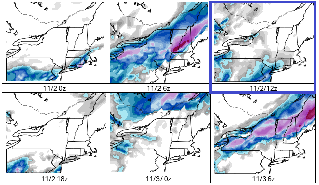
Aside from the 11/2 12z run of the GFS, the GFS is not showing an early season snowstorm in the New York City area. Outlier events typically do not verify when they lack support. So far, there is very little support on either the EPS or GEFS for the kind of snowstorm one run of the GFS showed yesterday. In general, one should wait for support to develop and run-to-run continuity to develop before embracing outlier events. The probability of the kind of event for New York City and its immediate suburbs shown yesterday remains low. More likely is a cold rain event with highs in the 40s with perhaps some flakes mixed in, though the mixing remains uncertain at this time. A better chance of snow exists for parts of the Poconos, Catskills, Adirondacks, and central/northern New England, which would include parts of Dutchess and Orange Counties.
-
Highs will reach the upper 50s and lower 60s through Wednesday. A weak cold front could cross the region after midweek, perhaps touching off a few scattered showers. Highs will then fall back to the lower and middle 50s before milder conditions return for a time next weekend. Afterward, there is the potential for a short but sharp cold shot, possibly preceded by a chilly rain. The ENSO Region 1+2 anomaly was +0.3°C and the Region 3.4 anomaly was -0.6°C for the week centered around October 22. For the past six weeks, the ENSO Region 1+2 anomaly has averaged -0.07°C and the ENSO Region 3.4 anomaly has averaged -0.48°C. La Niña conditions will likely continue through mid-winter. The SOI was +18.96 today. The preliminary Arctic Oscillation (AO) was +1.073 today.
-
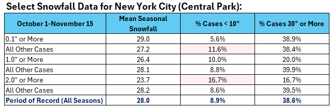
Here are the statistics for Central Park (1869-70 through 2024-25):
-
2025-2026 ENSO
donsutherland1 replied to 40/70 Benchmark's topic in Weather Forecasting and Discussion
I agree with your post. IMO, those maps should not be published on any credible site. Such wild swings and extremes on a run-to-run basis are not too surprising. That's why NCEP blends multiple cycles. -
I agree. It should also be noted that very few ensemble members show a measurable snow threat for NYC or its immediate suburbs. Yes, it's going to be unseasonably cool. But the threat to NYC and its immediate suburbs appears to be a cold rain with highs in the 40s. If a few wet flakes mixed in, it would be an early "win," but that isn't the base case. Tempting as it might be to take the GFS verbatim or amplify what is a cool synoptic situation into a wintry one (not supported right now), one should resist those temptations, starved for snow as many of us are. If things converge toward a colder, wintry outcome in the short-range, that would be different. The most likely outcome appears to be an accumulating snow threat that is confined to the Catskills, Adirondacks, and parts of Upstate New York and New England.
-
Highs will reach the middle and upper 50s in much of the region tomorrow. It will then turn slightly milder with highs in the upper 50s and lower 60s through the middle of next week. A weak cold front could cross the region after midweek, perhaps touching off a few scattered showers. Highs will then fall back to the lower and middle 50s. In the long-range, the guidance suggests that an AO+/NAO+ regime could develop during the first week of the month. As has often happened with the loss of strong blocking, a milder regime could develop shortly afterward. The ENSO Region 1+2 anomaly was +0.3°C and the Region 3.4 anomaly was -0.6°C for the week centered around October 22. For the past six weeks, the ENSO Region 1+2 anomaly has averaged -0.07°C and the ENSO Region 3.4 anomaly has averaged -0.48°C. La Niña conditions will likely continue through mid-winter. The SOI was +5.79 today. The preliminary Arctic Oscillation (AO) was -0.149 today. The NAO was -1.008.
-
2025-2026 ENSO
donsutherland1 replied to 40/70 Benchmark's topic in Weather Forecasting and Discussion
With a generally quiet subtropical jet, I suspect that any large snowstorms are more likely to be of the Miller B variety. Those typically favor the northern Mid-Atlantic/New England or New England. -
2025-2026 ENSO
donsutherland1 replied to 40/70 Benchmark's topic in Weather Forecasting and Discussion
Thanks. I fixed the typo. I am currently thinking NYC will see 15”-25” snowfall during 2025-2026. Of the 53 seasons with such snowfall, 16 (30.2%) had at least one 2-day figure of 10” or more. The most recent was 11.4”, February 8-9, 2013). The figure for all other seasons is 40.0%, meaning that it might be somewhat but not much more challenging to see such a snowfall this winter. Of course, that assumes my current thinking is accurate. -
2025-2026 ENSO
donsutherland1 replied to 40/70 Benchmark's topic in Weather Forecasting and Discussion
If a AO-/NAO-/PNA+ pattern develops, it would have a higher frequency of snowfall in the New York City area and Northeast. Right now, the EPS shows the AO and NAO going negative toward November 25. The PNA remains neutral. But at this range, there's little skill. So, here are the numbers for New York City for November 25-December 10. Add an EPO-, and the respective percentages are 5.6%, 4.5%, 2.2% (89 cases) with all other cases being 3.2%, 1.4%, and 0.5% respectively (631 cases). The EPS shows an EPO-. It should also be noted that numerous La Niña winters have gotten off to a fast start in terms of snowfall. Separately, there's a race in time between what might be a potentially favorable snowfall pattern and a dismal snowfall statistic for New York City. Through October 31, New York City has gone 1,371 consecutive days without a 4" or above daily snowfall. The same applies for a 5" or above daily snowfall. The futility record for both cases is 1,394 consecutive days (February 22, 1929 - December 16, 1932). The futility record could be tied on November 23 and broken on November 24.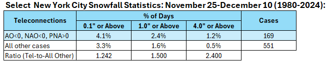
-
2025-2026 ENSO
donsutherland1 replied to 40/70 Benchmark's topic in Weather Forecasting and Discussion
It's something I'm watching. Some La Niñas have focused the coldest anomalies in the vicinity of the Great Lakes Region. Perhaps this will be the case. I'm hoping to see the ECMWF move in that direction when its new forecasts come out in a few days. -
2025-2026 ENSO
donsutherland1 replied to 40/70 Benchmark's topic in Weather Forecasting and Discussion
This is an experiment. I personally don't like 2011-12 and won't be using it in my winter outlook to be posted in mid-November. 2021-2022 is the only one from that set that will be used in my thinking. I'm just testing an experimental approach aimed at statistically generating analog cases with no human input to see how it does. -
2025-2026 ENSO
donsutherland1 replied to 40/70 Benchmark's topic in Weather Forecasting and Discussion
The December CANSIPS idea seems good to me. It’s also something one should expect with La Niña. -
2025-2026 ENSO
donsutherland1 replied to 40/70 Benchmark's topic in Weather Forecasting and Discussion
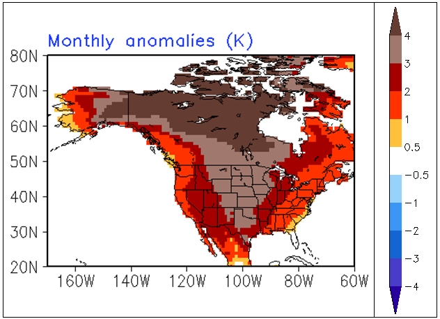
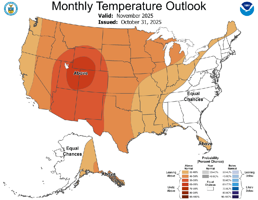
Continuing the test of the experimental objective analogs, here's the composite temperature idea for November: For comparison, below are the CFSv2 and CPC forecasts. CFSv2: CPC: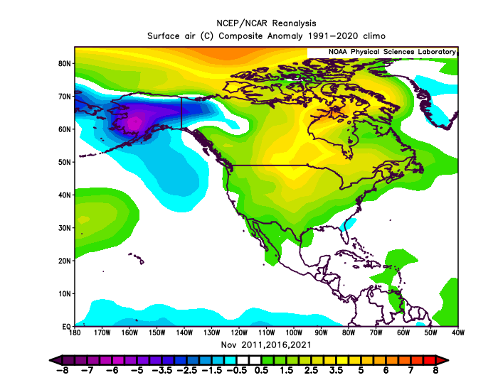
-
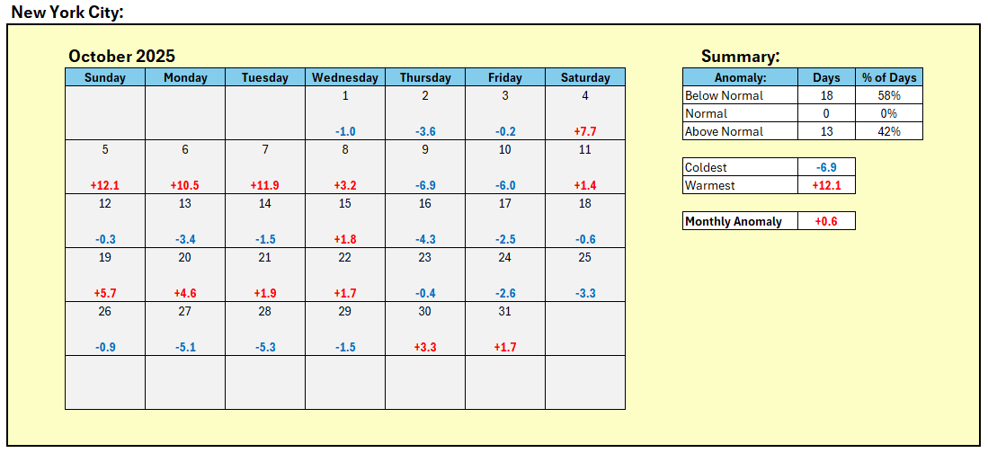
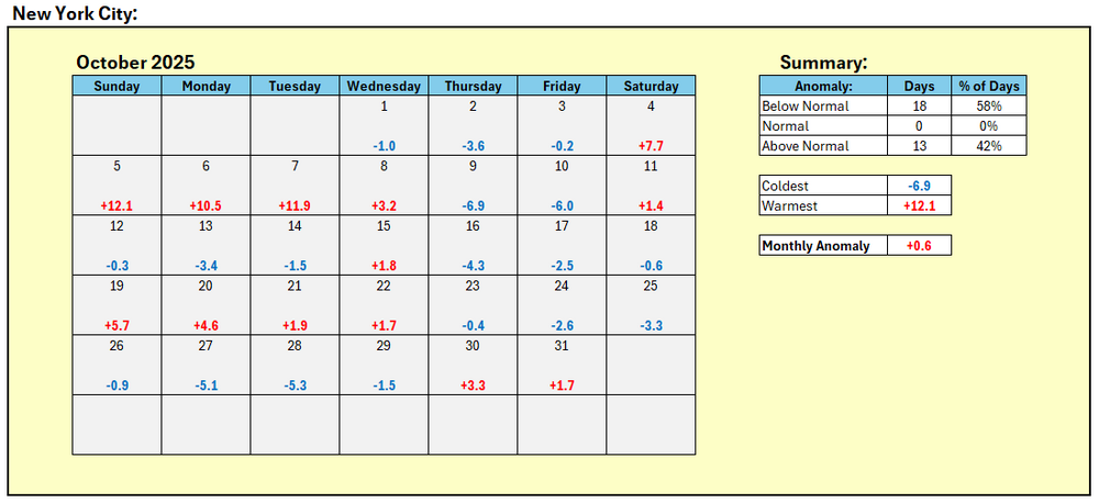
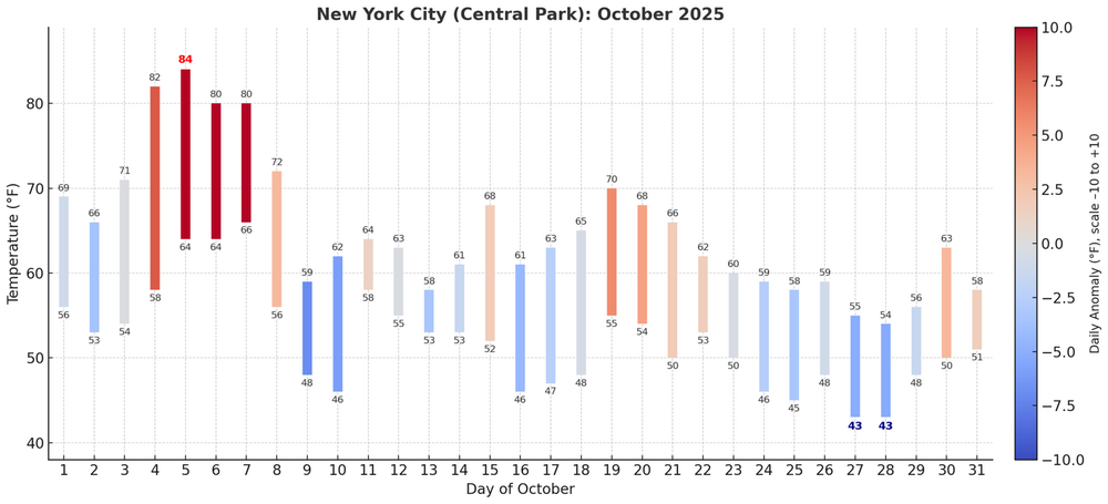
New York City finished with an October mean temperature of 58.5°, which was 0.6° above normal.
-
November is on track to finish with a mean temperature of 58.4° in New York City. That is 0.5° above normal and 1.5° above the earlier 1981-2010 baseline. Highs will reach the middle 50s in much of the region tomorrow and Sunday. Lows will mainly be in the lower and middle 40s in New York City and 30s outside the City. In the long-range, the guidance suggests that an AO+/NAO+ regime could develop the first week in November. As has often happened with the loss of strong blocking, a milder regime could develop late in the first week of November or shortly afterward. The ENSO Region 1+2 anomaly was +0.3°C and the Region 3.4 anomaly was -0.6°C for the week centered around October 22. For the past six weeks, the ENSO Region 1+2 anomaly has averaged -0.07°C and the ENSO Region 3.4 anomaly has averaged -0.48°C. La Niña conditions will likely continue through mid-winter. The SOI was +11.28 today. The preliminary Arctic Oscillation (AO) was -1.064 today. The NAO was -1.321.
-
November DCA _NYC _BOS __ORD _ ATL _IAH __ DEN _PHX _SEA 0.8 0.8 0.7 0.1 2.0 2.2 3.0 2.5 0.9
-
Event Discussion-OBS uncertain tracking thread for possible moderate impact event 8A Thu-8A Fri 10/30-31. Mainly 1-3" rains, G 45-55 MPH-mainly coast, and high prob of at least minor coastal flooding - Thursday afternoon high tide cycle.
donsutherland1 replied to wdrag's topic in New York City Metro
Final storm total rainfall amounts and select records for October 30: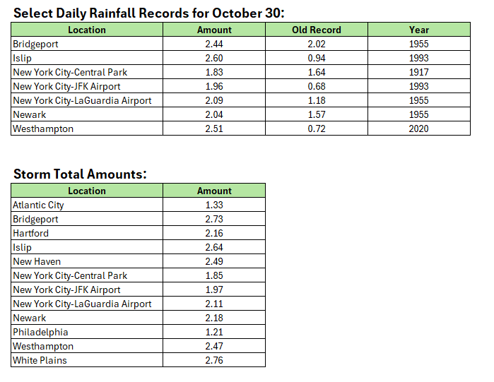
-
Event Discussion-OBS uncertain tracking thread for possible moderate impact event 8A Thu-8A Fri 10/30-31. Mainly 1-3" rains, G 45-55 MPH-mainly coast, and high prob of at least minor coastal flooding - Thursday afternoon high tide cycle.
donsutherland1 replied to wdrag's topic in New York City Metro
Updated figures for 10 pm: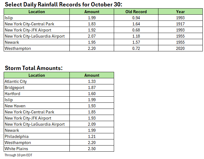
-
Event Discussion-OBS uncertain tracking thread for possible moderate impact event 8A Thu-8A Fri 10/30-31. Mainly 1-3" rains, G 45-55 MPH-mainly coast, and high prob of at least minor coastal flooding - Thursday afternoon high tide cycle.
donsutherland1 replied to wdrag's topic in New York City Metro
Updated figures for 9 pm: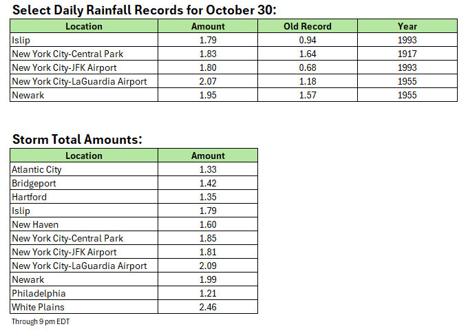
-
Event Discussion-OBS uncertain tracking thread for possible moderate impact event 8A Thu-8A Fri 10/30-31. Mainly 1-3" rains, G 45-55 MPH-mainly coast, and high prob of at least minor coastal flooding - Thursday afternoon high tide cycle.
donsutherland1 replied to wdrag's topic in New York City Metro
So far, the guidance signaling a significant rain event from the extended range seems to have fared very well. A general 1"-3" has been recorded over a large part of the region, with some locally higher amounts.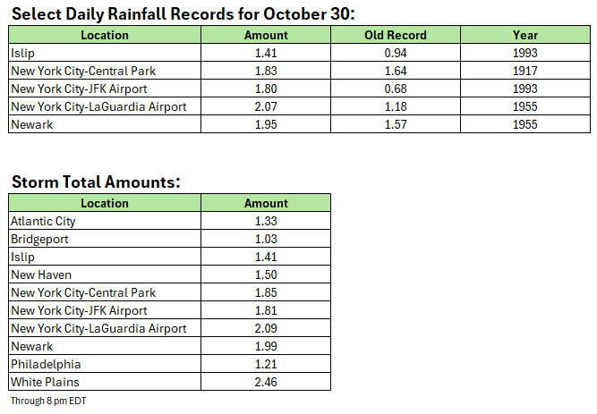
-
The storm is on track to deliver an expected total 1"-3" rainfall across the region into early tomorrow. A number of locations have seen peak rainfall rates in excess of 1" per hour including: JFK Airport: 1.07" LaGuardia Airport: 1.04" White Plains: 1.18" The system will be followed by a continuation of cool weather. Highs will reach the middle 50s in much of the region tomorrow through Sunday. Lows will mainly be in the lower and middle 40s in New York City and 30s outside the City. In the long-range, the guidance suggests that an AO+/NAO+ regime could develop the first week in November. As has often happened with the loss of strong blocking, a milder regime could develop late in the first week of November or shortly afterward. The ENSO Region 1+2 anomaly was +0.3°C and the Region 3.4 anomaly was -0.6°C for the week centered around October 22. For the past six weeks, the ENSO Region 1+2 anomaly has averaged -0.07°C and the ENSO Region 3.4 anomaly has averaged -0.48°C. La Niña conditions will likely continue through mid-winter. The SOI was +8.51 today. The preliminary Arctic Oscillation (AO) was -0.924 today. The NAO was -1.404. Based on sensitivity analysis applied to the latest guidance, there is an implied near 100% probability that New York City will have a warmer than normal October (1991-2020 normal). October will likely finish with a mean temperature near 58.3° (0.4° above normal). Supplemental Information: The projected mean would be 1.4° above the 1981-2010 normal monthly value.
-
Event Discussion-OBS uncertain tracking thread for possible moderate impact event 8A Thu-8A Fri 10/30-31. Mainly 1-3" rains, G 45-55 MPH-mainly coast, and high prob of at least minor coastal flooding - Thursday afternoon high tide cycle.
donsutherland1 replied to wdrag's topic in New York City Metro
As of 4 pm, New York City has seen 1.81" of rain. That breaks the daily record of 1.64" that was set in 1917. The hourly figure from 3 pm - 4 pm of 0.83" surpassed the hourly record for October 30 that was set during 1955.- 246 replies
-
- 4
-

-

-
- heavy rain
- damaging wind? squalls?
- (and 2 more)
-
Event Discussion-OBS uncertain tracking thread for possible moderate impact event 8A Thu-8A Fri 10/30-31. Mainly 1-3" rains, G 45-55 MPH-mainly coast, and high prob of at least minor coastal flooding - Thursday afternoon high tide cycle.
donsutherland1 replied to wdrag's topic in New York City Metro
Through 3:25 pm, Newark has picked up 1.91" of rain today. That breaks the daily record of 1.57" from 1955. Through 3:32 pm, LaGuardia Airport has seen 1.41" of rain. That breaks the daily mark of 1.18" from 1955.- 246 replies
-
- 3
-
-
-
- heavy rain
- damaging wind? squalls?
- (and 2 more)
-
2025-2026 ENSO
donsutherland1 replied to 40/70 Benchmark's topic in Weather Forecasting and Discussion
Some Washington, DC winter forecasts: https://wapo.st/3JxBxBT