donsutherland1
-
Posts
23,988 -
Joined
Content Type
Profiles
Blogs
Forums
American Weather
Media Demo
Store
Gallery
Everything posted by donsutherland1
-
11/8-11/10 First Snow and Lake Effect Event
donsutherland1 replied to Geoboy645's topic in Lakes/Ohio Valley
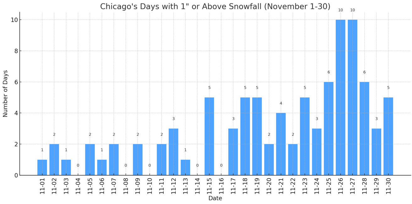
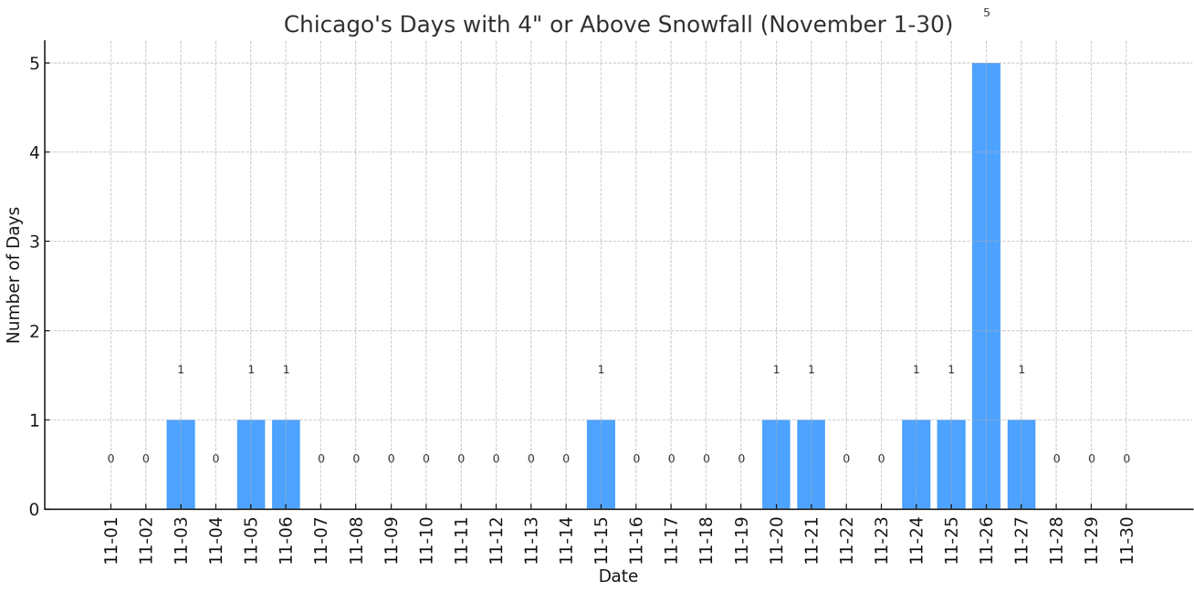
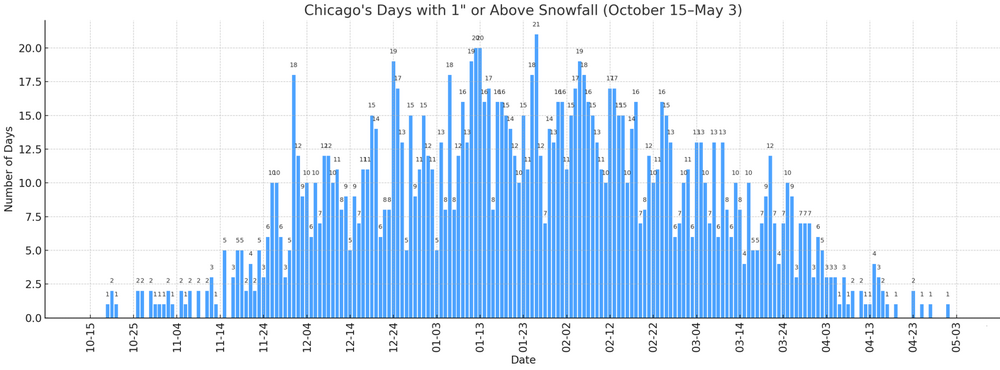
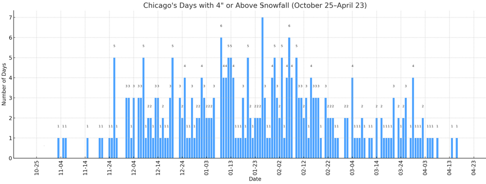
Yes, I agree. I don't see O'Hare getting the top-end accumulations. I still think 4" or above is reachable, but not guaranteed given this setup. -
11/8-11/10 First Snow and Lake Effect Event
donsutherland1 replied to Geoboy645's topic in Lakes/Ohio Valley
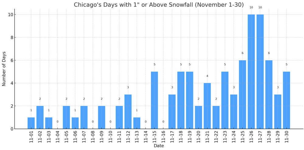
For reference, some historic data for Chicago: Frequency Data for Select November Daily Snowfall Amounts: And the histograms for the entire snow season: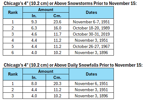

-
2025-2026 ENSO
donsutherland1 replied to 40/70 Benchmark's topic in Weather Forecasting and Discussion
OT: My flashdrive that contained the ENSO data became unreadable today. Fortunately, I have a backup that is reasonably up-to-date. Pre-device failure might have led to a corruption of the data e.g., the wrong ENSO values for some of the cases referenced previously in this discussion. In the meantime, it looks like Savannah could see its earliest first freeze since 2010. -
11/8-11/10 First Snow and Lake Effect Event
donsutherland1 replied to Geoboy645's topic in Lakes/Ohio Valley
Ottawa has a snowfall warming for 4"-8". Detroit to Toronto should also see measurable snowfall. Winter is getting off to a good start parts of the Great Lakes Region. From Environment Canada: 4:00 PM EST Saturday 8 November 2025 Snowfall Warning in effect for: Ottawa North - Kanata - Orléans Significant snowfall expected Sunday. What: Snowfall amounts of 10 to 20 cm. When: Beginning Sunday morning and continuing into Sunday night. Additional information: A low pressure system will bring snowfall to parts of southern Ontario on Sunday. Areas near the St. Lawrence River may see snow mix with ice pellets or freezing rain at times Sunday evening, leading to reduced snowfall amounts in that area. Motorists should expect difficult winter driving conditions and adjust travel plans accordingly. Poor weather conditions may contribute to transportation delays. Visibility will likely be reduced at times. -
Winter cancelled/uncancelled banter 25/26
donsutherland1 replied to Rjay's topic in New York City Metro
Welcome to the NY area. -
A strong cold front will cross the region tomorrow bringing this season's coldest temperatures so far early next week. Its passage could trigger some showers or a thunderstorm tomorrow into tomorrow night. The temperature will likely top out in the upper 50s and lower 60s tomorrow. Following the frontal passage, lows would fall well into the 30s in New York City while highs struggle to reach the lower 40s during the height of the early-season chill on Tuesday. The Deep South could see the temperature fall to record low levels, particularly on Tuesday. Parts of Florida will likely see a freeze. The ENSO Region 1+2 anomaly was +0.1°C and the Region 3.4 anomaly was -0.6°C for the week centered around October 29. For the past six weeks, the ENSO Region 1+2 anomaly has averaged -0.05°C and the ENSO Region 3.4 anomaly has averaged -0.52°C. La Niña conditions will likely continue through mid-winter. The SOI was +18.89 today. The preliminary Arctic Oscillation (AO) was -1.254 today. Based on sensitivity analysis applied to the latest guidance, there is an implied 54% probability that New York City will have a cooler than normal November (1991-2020 normal). November will likely finish with a mean temperature near 47.6° (0.4° below normal). Supplemental Information: The projected mean would be 0.1° below the 1981-2010 normal monthly value.
-
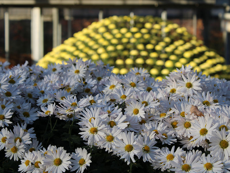
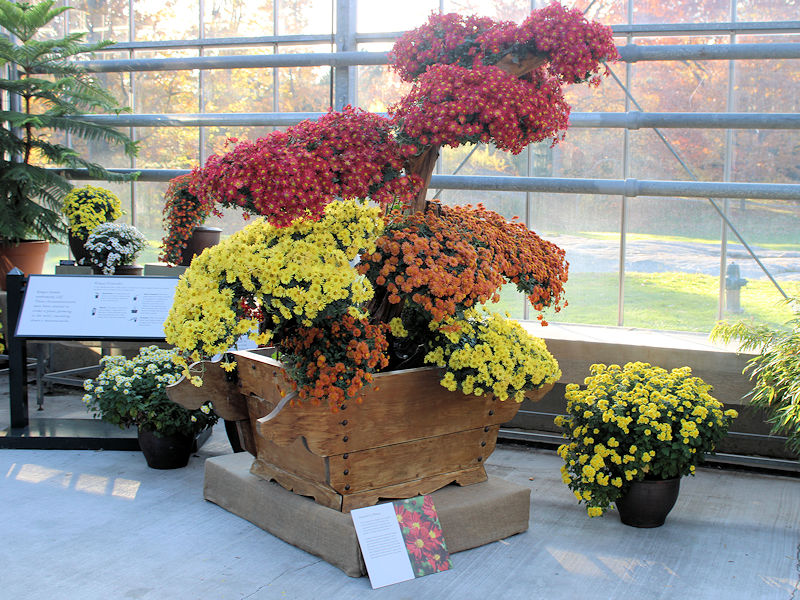
Under bright sunshine, deep blue skies, and a light breeze, the temperature soared into the lower and middle 60s across the New York City area. Some photos from the New York botanical Garden:


-
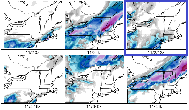
Revisiting the above post now that some time has passed. The general idea about being cautious about outlier model runs that lack support holds. Today's 12z run of the GFS: The National Blend of Models shows NYC's temperatures falling through the 50s during the showers/rain. That's somewhat warmer than previously shown on the guidance, but 40s remains a possibility. The outlier notion of an accumulating snowstorm is not plausible.
-
2025-2026 ENSO
donsutherland1 replied to 40/70 Benchmark's topic in Weather Forecasting and Discussion
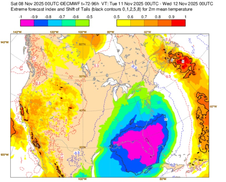
And for context: Low skill for much of the CONUS.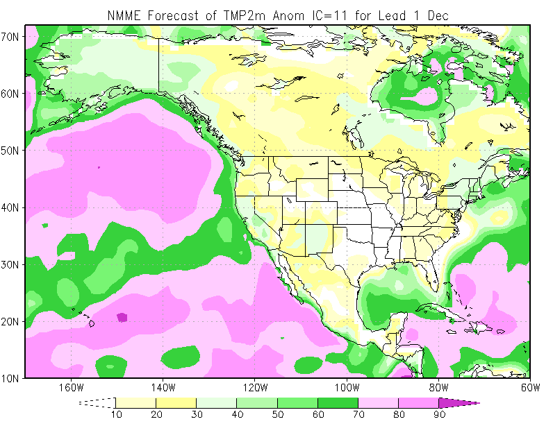
-
Many record lows will fall, especially in the South.
-
A quick note: Denver finally surpassed its monthly record that was set in 2006 this year. On November 2, the mercury topped out at 83° in Denver.
-
A few showers are possible overnight as a warm front moves across the region. The weekend will be unseasonably mild with tomorrow being the warmest day. Highs Tomorrow will likely reach the lower and perhaps middle 60s. Newark could again approach or reach 70°. A strong cold front will then bring this season's coldest temperatures so far early next week. It could trigger some showers or a thunderstorm Sunday evening or Sunday night. Afterward, lows would fall well into the 30s in New York City while highs struggle to reach the middle and upper 40s during the height of the early-season chill. The ENSO Region 1+2 anomaly was +0.1°C and the Region 3.4 anomaly was -0.6°C for the week centered around October 29. For the past six weeks, the ENSO Region 1+2 anomaly has averaged -0.05°C and the ENSO Region 3.4 anomaly has averaged -0.52°C. La Niña conditions will likely continue through mid-winter. The SOI was +29.26 today. The preliminary Arctic Oscillation (AO) was -0.721 today. Based on sensitivity analysis applied to the latest guidance, there is an implied 55% probability that New York City will have a cooler than normal November (1991-2020 normal). November will likely finish with a mean temperature near 47.5° (0.5° below normal). Supplemental Information: The projected mean would be 0.2° below the 1981-2010 normal monthly value.
-
Bridgeport, Islip, and White Plains all experienced their first freeze of the season. Today's Low Temperature and First Freeze Data: Bridgeport: 32°; Last Year: November 13; Normal: November 4 Islip: 32°; Last Year: November 10; Normal: October 28 White Plains: 32°; Last Year: November 13; Normal October 28
-
Tomorrow will be fair with temperatures topping out in the middle and upper 50s. The weekend will be unseasonably mild with Saturday being the warmest day. Highs on Saturday will likely reach the lower and perhaps middle 60s. Newark could again approach or reach 70°. A strong cold front will then bring this season's coldest temperatures so far early next week. Lows would fall well into the 30s in New York City while highs struggle to reach the middle and upper 40s. The ENSO Region 1+2 anomaly was +0.1°C and the Region 3.4 anomaly was -0.6°C for the week centered around October 29. For the past six weeks, the ENSO Region 1+2 anomaly has averaged -0.05°C and the ENSO Region 3.4 anomaly has averaged -0.52°C. La Niña conditions will likely continue through mid-winter. The SOI was +27.67 today. The preliminary Arctic Oscillation (AO) was -0.510 today.
-
2025-2026 ENSO
donsutherland1 replied to 40/70 Benchmark's topic in Weather Forecasting and Discussion
GaWx, Thanks. It looks like I messed up my pre-1980 values on the spreadsheet. By any chance, do you have a link to the monthly Region 1+2 anomalies. I can't find it on the moved ENSO page. -
2025-2026 ENSO
donsutherland1 replied to 40/70 Benchmark's topic in Weather Forecasting and Discussion
While those weren’t La Niña winters, I expanded the very limited dataset to include all years with rapid warming of ENSO Region 3.4 from a cool December figure. The response in January and February was the same with or without those two cases. -
2025-2026 ENSO
donsutherland1 replied to 40/70 Benchmark's topic in Weather Forecasting and Discussion
Were the La Niña to collapse prematurely, that would herald the likelihood of warmth in parts of the East in both January and February. Perhaps the best proxy for rapid collapses are cases where the ENSO R3.4 anomaly was -0.50° or below during December and >-0.50° during January. There were only four cases since 1950 that met that criteria: Winters 1951-52, 1952-53, 1974-75, and 2001-02. I don't expect this winter to meet such criteria. If so, the coming winter would wind up quite a bit warmer than what I'm currently thinking and also what the latest ECMWF suggested. -
As of 4 pm, the high temperature in New York City had reached 66°. That was a full 2 standard deviations above the NBM forecast from 11z, a remarkable bust. Newark was even warmer with a high of 70°. However, this warmth will be short-lived, as a cold front is now crossing the region. In doing so, it could trigger some widely scattered showers. Most areas will remain dry. The first half of tonight will be very windy. Winds will likely gust past 50 mph for several hours. Afterward, winds will slowly diminish. Highs will then fall back to the lower and middle 50s tomorrow and middle and upper 50s on Friday. The weekend will be mild with Saturday being the warmest day. Highs on Saturday will likely reach the lower and perhaps middle 60s. Newark could again approach or reach 70°. A strong cold front will then bring this season's coldest temperatures so far early next week. Lows would fall well into the 30s in New York City while highs struggle to reach the middle and upper 40s. The ENSO Region 1+2 anomaly was +0.1°C and the Region 3.4 anomaly was -0.6°C for the week centered around October 29. For the past six weeks, the ENSO Region 1+2 anomaly has averaged -0.05°C and the ENSO Region 3.4 anomaly has averaged -0.52°C. La Niña conditions will likely continue through mid-winter. The SOI was +26.97 today. The preliminary Arctic Oscillation (AO) was +0.140 today.
-
Tomorrow will be a mild day with highs reaching the lower 60s. A weak cold front could touch off a few scattered showers. It will turn increasingly windy following the frontal passage. Winds will likely gust past 50 mph for several hours. Highs will then fall back to the lower and middle 50s Thursday and Friday before milder conditions return for the weekend. Afterward, there is the potential for a short but sharp cold shot, possibly preceded by a chilly rain. Lows would fall well into the 30s in New York City while highs struggle to reach the middle and upper 40s. The ENSO Region 1+2 anomaly was +0.1°C and the Region 3.4 anomaly was -0.6°C for the week centered around October 29. For the past six weeks, the ENSO Region 1+2 anomaly has averaged -0.05°C and the ENSO Region 3.4 anomaly has averaged -0.52°C. La Niña conditions will likely continue through mid-winter. The SOI was +17.81 today. The preliminary Arctic Oscillation (AO) was +1.343 today.
-
2025-2026 ENSO
donsutherland1 replied to 40/70 Benchmark's topic in Weather Forecasting and Discussion
Nothing is cast in stone right now. Here are overall December cases: For recent La Niña events (1980-2025), December snowfall of 6" or above is more conducive to a snowy winter. Frequency of 30" or more for January-April: December < 4": 16.7% December 4" or above: 25.0% December 6" or above: 28.6% December 8" or above: 40.0%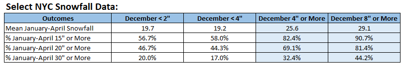
-
2025-2026 ENSO
donsutherland1 replied to 40/70 Benchmark's topic in Weather Forecasting and Discussion
I think he was referring to Eric's analogs. I might be wrong, though. -
2025-2026 ENSO
donsutherland1 replied to 40/70 Benchmark's topic in Weather Forecasting and Discussion
Yes. Fast start, then typically a collapse of winter. That may be the baseline for this coming winter where things get off to a good start and then winter ends prematurely. -
2025-2026 ENSO
donsutherland1 replied to 40/70 Benchmark's topic in Weather Forecasting and Discussion
In other words, things seem to be moving toward a vintage fast start to winter as is often, though not always, the case during La Niña winters. -
Yes, but sharp cold shots are still possible. Below normal months can also occur.
-
A few showers are possible tonight. Tomorrow and Wednesday will be mild days. Highs will reach the upper 50s and lower 60s. A weak cold front could cross the region Wednesday, perhaps touching off a few scattered showers. It will turn increasingly windy following the frontal passage. Highs will then fall back to the lower and middle 50s before milder conditions return for a time next weekend. Afterward, there is the potential for a short but sharp cold shot, possibly preceded by a chilly rain. The ENSO Region 1+2 anomaly was +0.1°C and the Region 3.4 anomaly was -0.6°C for the week centered around October 29. For the past six weeks, the ENSO Region 1+2 anomaly has averaged -0.05°C and the ENSO Region 3.4 anomaly has averaged -0.52°C. La Niña conditions will likely continue through mid-winter. The SOI was +18.96 today. The preliminary Arctic Oscillation (AO) was +1.583 today.