donsutherland1
-
Posts
23,988 -
Joined
Content Type
Profiles
Blogs
Forums
American Weather
Media Demo
Store
Gallery
Everything posted by donsutherland1
-
2025-2026 ENSO
donsutherland1 replied to 40/70 Benchmark's topic in Weather Forecasting and Discussion
Of course. WPO-/EPO- can force cold outcomes even with a positive AO and NAO. But if one is referring only to the general AO/NAO state, positive states are typically warmer, not colder regardless of ENSO. Other variables weren’t noted. -
2025-2026 ENSO
donsutherland1 replied to 40/70 Benchmark's topic in Weather Forecasting and Discussion
Cold is not favored in the East during February AO+/NAO+ dates. Nearly two thirds are warmer than normal. -
A milder pattern is now in place. The remainder of the week will see generally above normal temperatures. Some rain is likely Saturday into Sunday. Rainfall amounts will generally be between 0.50"-1.00". The week will conclude with highs finishing in the 50s across much of the region on Friday and Saturday. Cooler air will likely return Sunday or Monday. No significant Arctic blasts or significant snowfalls are likely through at least mid-January. Afterward, conditions might become more favorable for both cold and snowfall, especially if the PNA goes positive. PNA-related developments would have larger implications for snowfall. A persistently positive PNA would have above climatological risk of moderate or significant snowfalls. A mainly negative PNA would favor mainly small snowfalls. It will likely be a few more days before the guidance reaches the high-skill timeframe for teleconnection forecasts. The ENSO Region 1+2 anomaly was -0.7°C and the Region 3.4 anomaly was -0.5°C for the week centered around December 31. For the past six weeks, the ENSO Region 1+2 anomaly has averaged -0.37°C and the ENSO Region 3.4 anomaly has averaged -0.63°C. La Niña conditions will likely continue into at least late winter. The SOI was +2.31 today. The preliminary Arctic Oscillation (AO) was +0.377 today. Based on sensitivity analysis applied to the latest guidance, there is an implied near 50% probability that New York City will have a cooler than normal January (1991-2020 normal). January will likely finish with a mean temperature near 33.7° (at normal). Supplemental Information: The projected mean would be 1.1° above the 1981-2010 normal monthly value.
-
Great find, Tip. The underlying paper is here for anyone looking for a quick link: https://www.nature.com/articles/s41586-025-09895-y
-
2025-2026 ENSO
donsutherland1 replied to 40/70 Benchmark's topic in Weather Forecasting and Discussion
It will be interesting to see how this plays out. During the 2016-2017 weak La Niña event, which collapsed in January, there was also a powerful WWB. Indeed, the SOI plunged to -33.54 on January 19th. It remains to be seen if that WWB will actually be rivaled, much less surpassed. The 2016-17 La Niña had two days in January where the SOI was -30 or below. No other La Niña event had even one. However, daily SOI values only go back to 1991. February 2017 was truly a "torch" in much of the eastern half of the U.S. I'm not expecting anything along those lines. But the idea that a cold or very cold outcome for February is a "slam dunk" following a powerful January WWB should it occur as modeled, is probably too simplistic. As noted above, 2016-17 saw the opposite outcome. A rapidly weakening La Niña would become less of a factor in influencing patterns. As that happens, other variables, many of which cannot be forecast at current lead times, will gain importance. This competition among variables could lead to large variability on a week-to-week basis. The changeable outcome on the extended range of the ECMWF weeklies may be offering an early hint of that variability. For now, at least based on past late-stage weak La Niña events, the best chances for monthly cold anomalies likely are the Plains States, Great Lakes Region, and eastward into the Northeast. Cold anomalies from the Southwest eastward through the Southeast would be far less likely. -
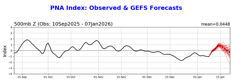
The signal for a PNA+ (a rarity since December 1) has grown stronger on the GEFS. Should a PNA+ develop and then be sustained, opportunities for moderate or larger snowfalls would increase, especially around or after mid-month.
-
Editing suggestion: Glass is really half empty for you
-
2025-2026 ENSO
donsutherland1 replied to 40/70 Benchmark's topic in Weather Forecasting and Discussion
I didn't comment in detail on this due to having the flu. This outcome doesn't surprise me much. It seems that they continue to have a tendency to swing for the fences (likely in pursuit of clicks/views). Hype prevails on social media, because there is no meaningful consequence for failure. There is no verification. If one is looking for reasonable idea where it's going to be warmer or colder than normal, taking the consensus of the top 5-10 AmWx monthly forecasters in the nine-city contest run by @Roger Smith would generally beat BAM and probably most of the social media forecasters on a regular basis. No one in the AmWx contest is seeking clicks/views. Thus, there is no incentive to hype. That creates a stronger foundation for robust and objective forecasting. January will likely provide a nice example. BAM went cold for the SE. The AmWx forecast was warm (consensus forecasts for Atlanta were +1.3° for the top 5 and +1.4° for the top 10. -
Milder weather has moved into the region. The remainder of the week will see generally above normal temperatures. Some rain is possible starting late Friday or Friday night. Periods of rain could extend into Sunday. The week will conclude with highs finishing in the 50s across much of the region on Friday and Saturday. Cooler air will likely return Sunday or Monday. No significant Arctic blasts or significant snowfalls are likely through at least mid-January. Afterward, conditions might become more favorable for both cold and snowfall, especially if the PNA goes positive. PNA-related developments would have larger implications for snowfall. It will likely be a few more days before the guidance reaches the high-skill timeframe for teleconnection forecasts. The ENSO Region 1+2 anomaly was -0.7°C and the Region 3.4 anomaly was -0.5°C for the week centered around December 31. For the past six weeks, the ENSO Region 1+2 anomaly has averaged -0.37°C and the ENSO Region 3.4 anomaly has averaged -0.63°C. La Niña conditions will likely continue into at least late winter. The SOI was +8.15 today. The preliminary Arctic Oscillation (AO) was -0.850 today.
-
2025-2026 ENSO
donsutherland1 replied to 40/70 Benchmark's topic in Weather Forecasting and Discussion
Several thoughts as we move deeper into January. La Niña is clearly waning. Region 3.4 has seen some recent warming. But La Niña is still having an influence. In a visible sign that there remains ocean-atmosphere coupling, the AAM is negative and forecast to remain negative for at least the next 7-10 days. As the La Niña wanes, its influence will also fluctuate. Fading weak La Niña events have mixed outcomes for February. This mixture of outcomes suggests that atmospheric patterns begin to carry greater weight as ENSO forcing weakens. By the end of the week, it will become clearer whether the PNA will move toward a regime change or a highly unusual brief PNA+ period followed by a resumption of a mainly negative PNA. By that time, the teleconnection guidance will be in its high-skill forecasting range. The base case remains a turn toward colder but not necessarily severely cold weather during the second half of January. The southern tier may still see only temporary intrusions of cold air. Snowfall prospects for the East Coast will depend heavily on the evolution of the PNA. In any case, at least through mid-month, significant snowfalls are unlikely for the East, as well as parts of the Great Lakes Region. -
2025-2026 ENSO
donsutherland1 replied to 40/70 Benchmark's topic in Weather Forecasting and Discussion
The Gulf Stream has an impact on storms/storm tracks. if the warmth is farther south, than all things being equal, storm tracks should be farther south. Another likely factor is how quiet the subtropical jet has been. That further reduces Miller A-type opportunities. -
Milder weather will begin to overspread the region tomorrow. A few snow flurries are possible during the morning with some sprinkles and showers possible later in the day. Some rain is possible on Friday into Saturday. The week will conclude with highs finishing in the 50s across much of the region on Friday and Saturday. Cooler air will likely return Sunday or Monday. Afterward, conditions could become more favorable for both cold and snowfall, especially if the PNA goes positive. It will likely be a few more days before the guidance reaches the high-skill timeframe for teleconnection forecasts. The ENSO Region 1+2 anomaly was -0.7°C and the Region 3.4 anomaly was -0.5°C for the week centered around December 31. For the past six weeks, the ENSO Region 1+2 anomaly has averaged -0.37°C and the ENSO Region 3.4 anomaly has averaged -0.63°C. La Niña conditions will likely continue into at least late winter. The SOI was +9.43 today. The preliminary Arctic Oscillation (AO) was -2.262 today.
-
A few snow showers are possible in parts of the region late tonight and early tomorrow. Some areas could receive a dusting of snow. Tomorrow will see highs finish near or just above freezing in New York City. Milder weather will likely begin to overspread the region on Tuesday. The milder period appears likely to last for about a week, but there is some uncertainty about its duration. Afterward, conditions could become more favorable for both cold and snowfall, especially if the PNA goes positive. Rain is possible on Friday into Saturday. The ENSO Region 1+2 anomaly was -0.3°C and the Region 3.4 anomaly was -0.7°C for the week centered around December 24. For the past six weeks, the ENSO Region 1+2 anomaly has averaged -0.33°C and the ENSO Region 3.4 anomaly has averaged -0.68°C. La Niña conditions will likely continue into at least late winter. The SOI was +11.55 today. The preliminary Arctic Oscillation (AO) was -2.939 today.
-
A few flurries are possible in parts of the region late tonight and early tomorrow. Some areas could receive a dusting of snow. Tomorrow and Monday will be mainly dry and unseasonably cool days with highs finishing near freezing in New York City. Milder weather will likely begin to overspread the region on Tuesday. The milder period appears likely to last for about a week, but there is some uncertainty about its duration. Afterward, conditions could become more favorable for both cold and snowfall, especially if the PNA goes positive. The ENSO Region 1+2 anomaly was -0.3°C and the Region 3.4 anomaly was -0.7°C for the week centered around December 24. For the past six weeks, the ENSO Region 1+2 anomaly has averaged -0.33°C and the ENSO Region 3.4 anomaly has averaged -0.68°C. La Niña conditions will likely continue into at least late winter. The SOI was +9.62 today. The preliminary Arctic Oscillation (AO) was -2.782 today.
-
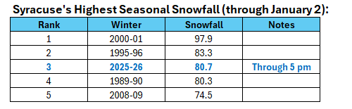
Syracuse is off to its third fastest start in terms of seasonal snowfall.
-
Texas 2026 Discussion/Observations
donsutherland1 replied to Stx_Thunder's topic in Central/Western States
The temperature soared to 89F (31.7C) in San Antonio. That tied the all-time January record that was set on January 30, 1971. -
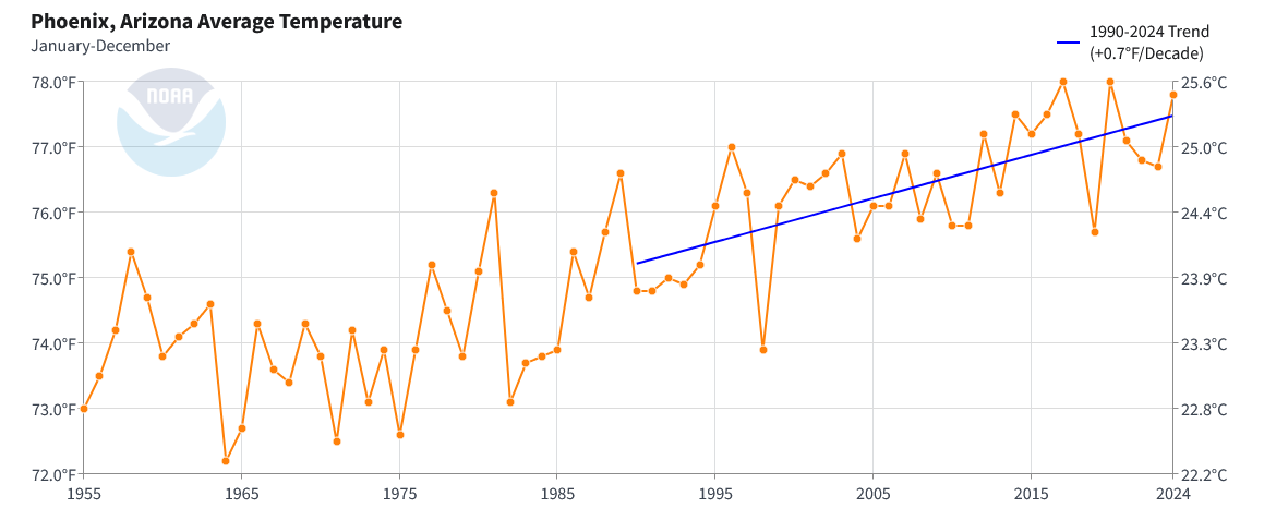
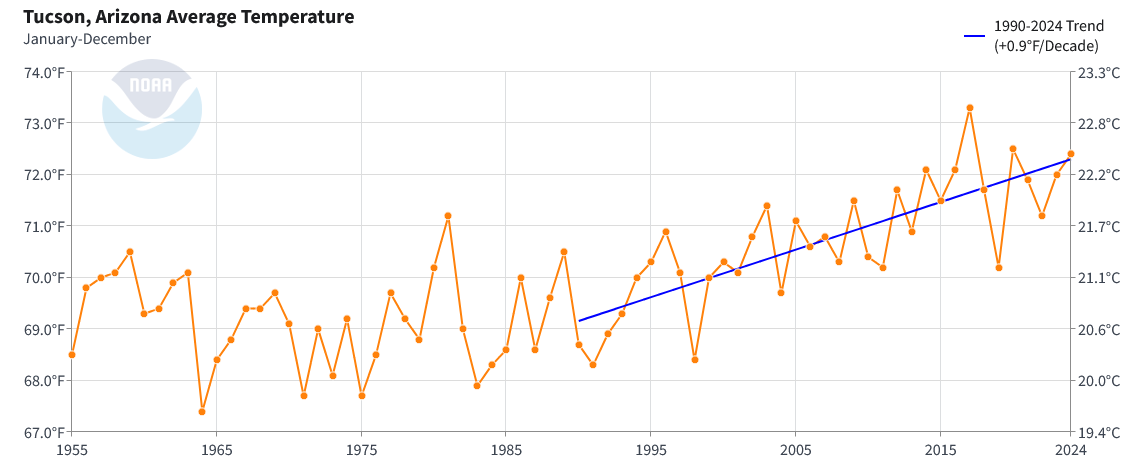
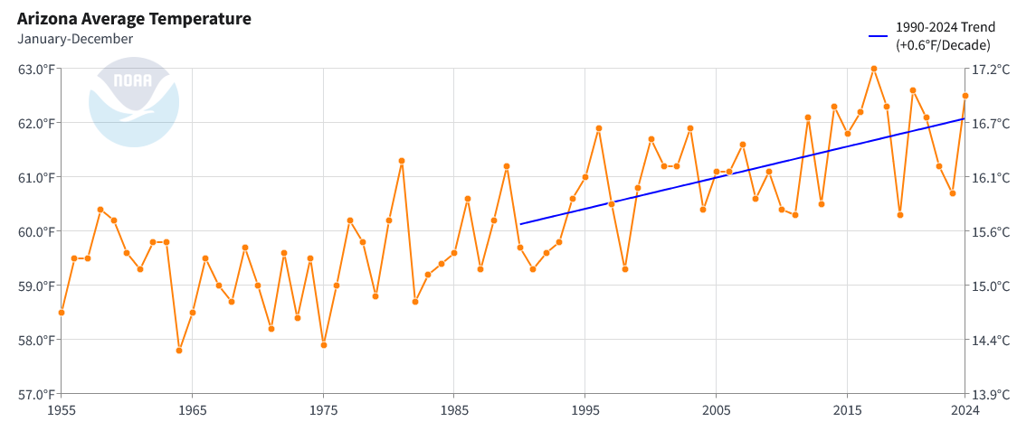
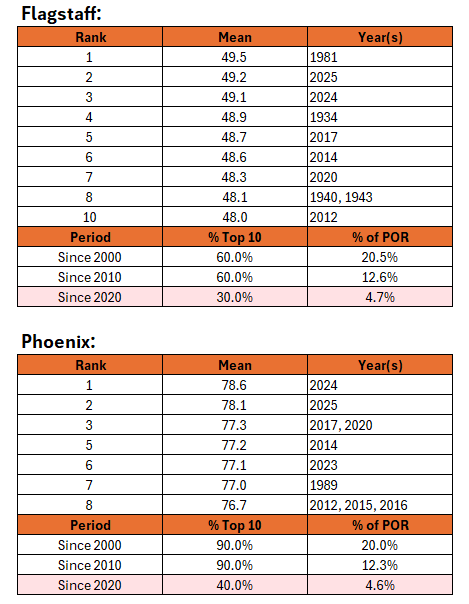
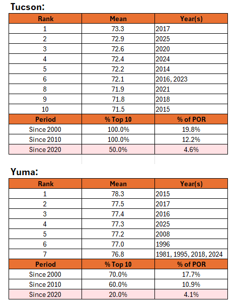
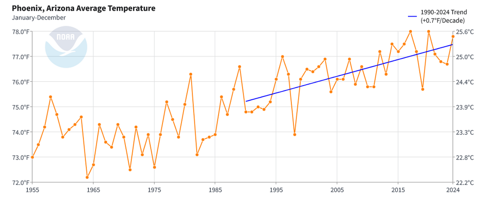
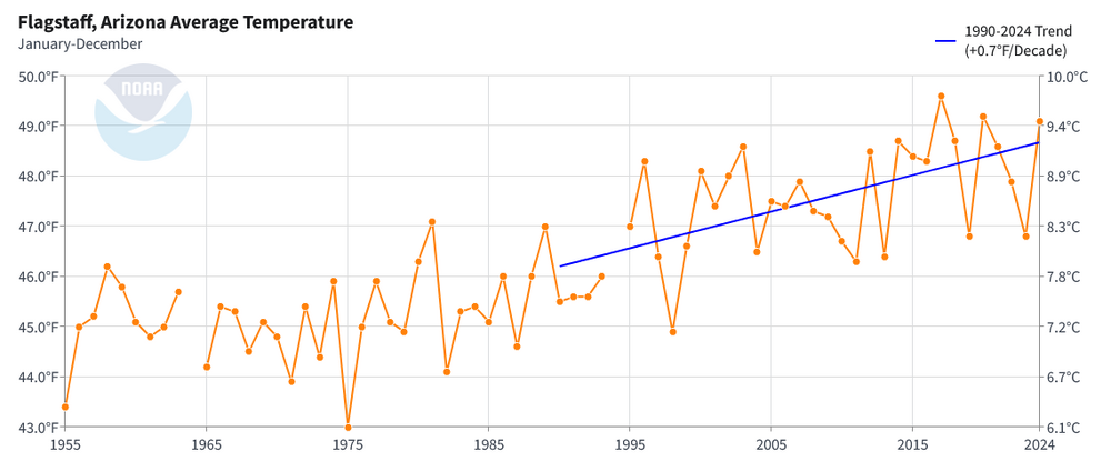
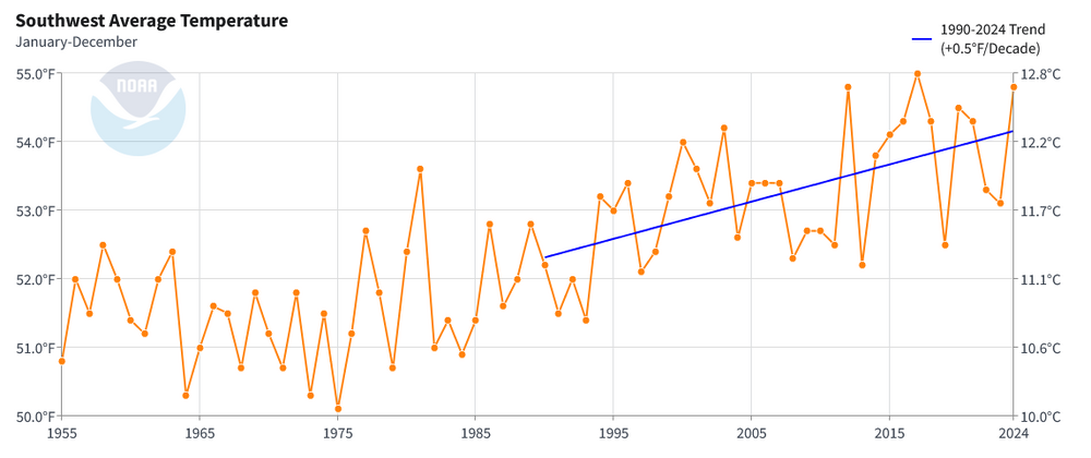
Monthly outcomes are the result of climate change, synoptic patterns and, in the major cities, urban heat island effect. Monthly outcomes are useful for illustrating how synoptic patterns translate in a warming climate. Flagstaff, Phoenix, Tucson, and Yuma have all seen a disproportionate share of their top 10 warmest years since 2000, 2010, and 2020. This skewing of results speaks strongly, but not entirely, of how the region's climate has changed. Similar skewing can be seen in the Arizona statewide data for warmest years and the Southwest regional data for the warmest years.
-
The weekend looks to be mainly dry with colder than normal temperatures. A few flurries are possible in parts of the region early Sunday. The first week of January could have a mean temperature below 30° in New York City. If that happends, it would be the coldest opening week of January since 2018. The only years since 2000 with a sub-30° mean temperature for the opening week of January were 2001, 2010, 2014 and 2018. Milder weather will likely develop on or around January 7th. The milder period appears likely to last for about a week, but there is some uncertainty about its duration. Afterward, conditions could become more favorable for both cold and snowfall, especially if the PNA goes positive. The ENSO Region 1+2 anomaly was -0.3°C and the Region 3.4 anomaly was -0.7°C for the week centered around December 24. For the past six weeks, the ENSO Region 1+2 anomaly has averaged -0.33°C and the ENSO Region 3.4 anomaly has averaged -0.68°C. La Niña conditions will likely continue into at least late winter. The SOI was +9.29 today. The preliminary Arctic Oscillation (AO) was -1.828 today.
-
We won't know until the data is posted this evening. There were no local storm reports.
-
2025-2026 ENSO
donsutherland1 replied to 40/70 Benchmark's topic in Weather Forecasting and Discussion
Today is the 32nd consecutive day on which the PNA is < 0. Despite the EPS and GEFS currently showing only a brief turn to positive, the historic evidence since 1980 suggests that a regime change to an extended period of a predominantly positive PNA is likely once the current stretch of PNA- concludes. Until one is in the short-range of the teleconnection forecasts, the base case remains a regime shift in the PNA, not a temporary fluctuation to positive values. All 10 prior streaks of 30 or more consecutive days since 1980 ended with a regime change in the PNA.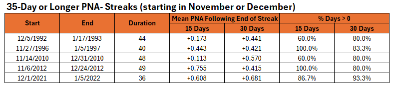
-
26 winters would like to reclaim their snowstorms.
-
Phoenix is a high profile city in a rapidly warming region. A focus on Phoenix with respect to the region's changing climate makes good sense. A warming climate leads to an increased frequency of warm temperature records, all other variables notwithstanding. Additional variables include synoptic patterns and the urban heat island effect. Overall, the climatic warming is not unique to Phoenix. Moreover, despite misinformed social media efforts following Phoenix's August-record 118° temperature, the siting of the thermometer is irrelevant. The site has been certified and it is one of only a handful with a backup sensor to assist with validation. It also has an outstanding NWS office that is exceptionally responsive to possible issues when they occasionally arise. Some temperature trends in Phoenix, Tucson, Flagstaff, Arizona, and the Southwest are below. Phoenix is in line with Arizona's major cities and not out-of-line with either the entire state of Arizona or the Southwest, which include many rural areas. The modest differences suggest that most of the recent long-term warming is now being driven by the region's changing climate, not factors specific to Phoenix.


-
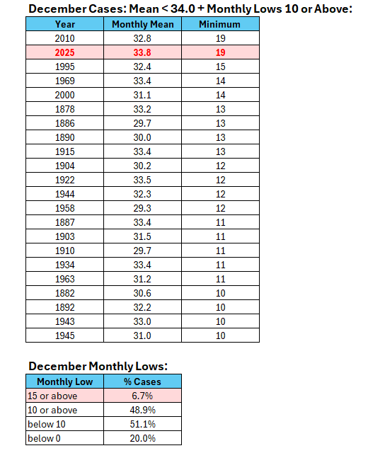
December 2025 tied Central Park's record for the highest monthly minimum temperature for any December with a monthly mean temperature below 34.0°. Fun fact: 15/21 (71%) of those cases prior to 2025 had seasonal snowfall of 30" or more, including 9/21 (43%) with 40" or more. Just 1/21 (5%) had less than 20" seasonal snowfall (1958-59 with 13.0").
-
I hope you feel better.