

donsutherland1
-
Posts
23,988 -
Joined
Content Type
Profiles
Blogs
Forums
American Weather
Media Demo
Store
Gallery
Everything posted by donsutherland1
-
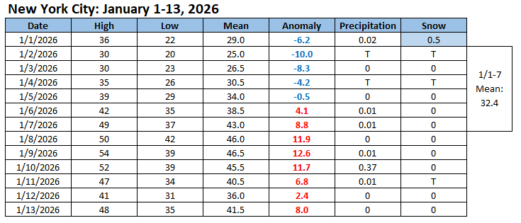
A sustained colder-than-normal period is commencing. The temperature will tumble into the 20s overnight and then rise only to the middle 30s tomorrow. With the exception of Saturday, highs will be mainly in the lower and middle 30s in New York City on Sunday and Monday. Arctic air will move into the region on Monday night. Tuesday could be the coldest day so far this season. Wednesday will be another unseasonably cold day. Temperatures will remain below normal through at least the most of next week. Flurries and perhaps a heavier snow shower are possible on Saturday and Sunday as a renewed flow of cold air moves across the region. Any accumulations should be light (mainly a coating to an inch). A coastal storm could begin to develop off the Southeast coast and then track south and east of the 40N-70W benchmark. On such a track, it could bring a period of light snow to eastern Long Island into southeastern New England on Sunday into Sunday night. After January 20th, conditions could become more favorable for both cold and snowfall. The probability of a PNA+ regime has increased in recent days. PNA-related developments would have larger implications for snowfall. A persistently positive PNA would have above climatological risk of moderate or significant snowfalls. A mainly negative PNA would favor mainly small snowfalls. The ENSO Region 1+2 anomaly was -0.7°C and the Region 3.4 anomaly was -0.8°C for the week centered around January 7. For the past six weeks, the ENSO Region 1+2 anomaly has averaged -0.47°C and the ENSO Region 3.4 anomaly has averaged -0.67°C. La Niña conditions will likely continue into at least late winter. The SOI was +11.08 today. The preliminary Arctic Oscillation (AO) was +0.231 today. Based on sensitivity analysis applied to the latest guidance, there is an implied near 60% probability that New York City will have a cooler than normal January (1991-2020 normal). January will likely finish with a mean temperature near 33.1° (-0.6° below normal). Supplemental Information: The projected mean would be 0.5° above the 1981-2010 normal monthly value.
-
Storm potential January 17th-18th
donsutherland1 replied to WeatherGeek2025's topic in New York City Metro
The ECMWF has not said that the EC-AI will replace the operational model. It complements it. https://www.ecmwf.int/en/about/media-centre/news/2025/ecmwfs-ai-forecasts-become-operational -
2025-2026 ENSO
donsutherland1 replied to 40/70 Benchmark's topic in Weather Forecasting and Discussion
Dandelions are tough. They are year-round in the New York City area. Obviously, they are few in number during the winter, but there are some around. -
As some have referenced the February 2006 blizzard, below are select AFDs leading up to and during the blizzard and a PNS from the event. February 7, 2006 5:25 pm: MODELS HAVE CEASED ANY SUGGESTION OF A STRONG COASTAL LOW AFFECTING THE REGION OVER THE WEEKEND IN FAVOR OF A WEAKER LOW THAT TRACKS WELL SOUTH AND EAST OF THE AREA. GIVEN THE STRUCTURE OF THE HEIGHTS ALOFT...IT MAKES SENSE THAT LOW DEVELOPMENT ALONG THE SOUTHEASTERN UNITED STATES WOULD BE CARRIED OUT TO SEA. THERE WILL HAVE TO BE A SIGNIFICANT CHANGE IN THE SOLUTION FOR THE HEIGHT FIELDS ALOFT FOR A LOCAL IMPACT. MOST SIGNIFICANT SIGNAL IN THE LONG TERM IS THE ONE FOR THE UPPER LEVEL TROUGH. RIGHT NOW...THERE DONT APPEAR TO BE ANY STRONG SHORTWAVES IN A POSITION TO SPIN UP SURFACE LOWS THAT WOULD SIGNIFICANTLY IMPACT THE TRI-STATE AREA...JUST THE APPROACH OF A WEAK CLIPPER. THEREFORE...WILL GENERALLY GO WITH A MORE PESSIMISTIC SKY COVER FORECAST...BUT WILL DOWNPLAY POPS AND WEATHER. GRIDS WILL INCLUDE A LOW CHANCE OR SLIGHT CHANCE OF SNOW SHOWERS FROM FRIDAY INTO SUNDAY. TEMPERATURES WILL AVERAGE A COUPLE DEGREES ON THE COLD SIDE OF NORMAL...AN ANOMALY FOR 2006...BUT NOTHING EXTRAORDINARY. February 8, 2006 4:00 AM: THE 00Z OPERATIONAL GFS AND ENSEMBLE MEAN ARE POINTING TOWARD A STRONGER LOW PRESSURE SYSTEM HANGING CLOSER TO THE COAST OVER THE WEEKEND THAN PREVIOUSLY FORECAST...BUT ENSEMBLE SPREAD RE DEPTH OF EASTERN H5 TROUGH IS LARGE AND ONLY ONE MEMBER TRACKS THE LOW INSIDE THE 40/70 BENCHMARK. THE 00Z ECMWF STILL FAVORS A WEAKER/MORE OFFSHORE SOLUTION...SO ALL IN ALL DECIDED TO LET PREVIOUS FORECAST OF CHANCE/SLIGHT CHANCE POP FOR THE WEEKEND RIDE. TEMPERATURES WILL AVERAGE A COUPLE DEGREES ON THE COLD SIDE OF NORMAL...AN ANOMALY FOR 2006...BUT NOTHING EXTRAORDINARY. February 8, 2006 3:31 PM: BASICALLY 2 MODEL CAMPS THE CANADIAN/NOGAPS/EXTENSION OF NAM W/ A WEAKER SYSTEM PASSING WELL OFFSHORE (BUT QUITE A BIT SLOWER THAN OTHER CAMP)...THIS WOULD SPELL NO PRECIPITATION FOR THE REGION...JUST CONTINUED COLD. THE OTHER CAMP IS THE GFS/UKMET/ECMWF WHICH HAVE A COASTAL LOW DEEPEN OFF NEAR THE SE THEN MID ATLANTIC COASTS SAT AND SAT NIGHT AND THEN PASS SOMEWHERE SE OF CAPE COD FROM SUNDAY INTO SUNDAY NIGHT. HAVE OPTED FOR THE LATTER CAMP FOR NOW AS MOST MODELS HAVE TRENDED IN THIS DIRECTION OVER THEIR PAST FEW RUNS. FOR NOW ECMWF IS IN BETWEEN UKMET AND GFS TRACK (AND A TAD SLOWER AND WEAKER)...SO BASICALLY FOLLOWED AS A COMPROMISE...BUT NOTE THAT MANY GFS ENSEMBLE MEMBERS SUPPORT THE OPERATIONAL 12Z GFS SOLUTION SO THE SITUATION BEARS CLOSE WATCHING. FOR NOW HAVE GONE WITH CHANCE POPS FOR SNOW SAT NIGHT AND SUNDAY...THEN SLIGHT CHANCE POPS EASTERN 1/3 SUNDAY NIGHT AS STORM DEPARTS. WHILE THERE IS THE POTENTIAL FOR SIGNIFICANT SNOWS...ESPECIALLY ACROSS EASTERN PORTIONS OF THE AREA...THERE IS TOO MUCH UNCERTAINTY TO ISSUE ANY STATEMENTS AT THIS TIME...ESPECIALLY WHEN THE CHANCE THAT WE COULD GET NOTHING IS RUNNING ABOUT 30-40 PCT IN MY OPINION. THE ONLY PLACE REGARDLESS OF MODEL CHOSEN WHERE P-TYPE MIGHT BE AN ISSUE IS WELL OFFSHORE (20+ MILES OUT SO WENT WITH MIX R/S THERE). February 9, 2006 3:59 AM: POTENTIAL FOR COASTAL STORM SATURDAY INTO SUNDAY...BUT UNCERTAINTY AS TO HOW CLOSE THE LOW WILL PASS TO THE AREA. WILL CONTINUE WITH THE CHANCE POPS FOR SNOW DEVELOPING DURING SATURDAY AFTERNOON AS LOW DEVELOPS OFF THE SOUTHEASTERN COAST. NAM TRACKING THE LOW FURTHER SOUTH AND EAST WITH LITTLE IF ANY PRECIPITATION AND GFS BRINGS LOW ALONG THE COAST SATURDAY AFTERNOON PASSING EAST OF MONTAUK POINT LATE SATURDAY NIGHT WITH THE POTENTIAL FOR A MORE SIGNIFICANT SNOW EVENT. February 9, 2006 3:39 PM: MODELS BEGIN TO DIVERGE SATURDAY ON TRACK OF LOW PRESSURE SYSTEM CURRENTLY DEVELOPING OVER OLD MEXICO IN RESPONSE TO 5H LOW EJECTING OUT OF BAJA CALIFORNIA. HANDLING OF NORTHERN STREAM IS SIMILAR WITH ALL MODELS...IT IS THE HANDLING OF THE SOUTHERN STREAM AND THE DEGREE OF PHASING WITH THE NORTHERN STREAM WHERE THE MODELS DIFFER AND RESULTS IN A SPREAD OF SURFACE SOLUTIONS. ONE THING THAT NAM/GFS/ECMWF/CMC/NOGAPS ALL AGREE ON IS THAT THERE WILL BE A LOW THAT BOMBS IN THE WATERS TO THE SOUTH OF NEW ENGLAND SATURDAY NIGHT AND THEN LIFTS NORTHEAST TO SOMEWHERE NEAR TO SOUTHEAST OF CAPE COD BY SUNDAY AFTERNOON. 18Z NAM HAS NOW COME IN LINE WITH 12/6/0Z GFS AND 12/0Z GFS ENSEMBLE MEAN IN SUGGESTING A LOW TRACK ACROSS THE CAROLINA COASTAL PLAIN SATURDAY...JUST OFF THE MID ATLANTIC COAST SATURDAY NIGHT...THEN PASSING SE OF CAPE COD SUNDAY. THE 18Z NAM IS HOWEVER ABOUT 6 HOURS SLOWER THAN THE GFS. THE CMC/ECMWF/NOGAPS ARE FURTHER TO THE EAST...WITH CMC HAVING TIMING SIMILAR TO THE GFS AND THE ECMWF/NOGAPS SIMILAR TO THE NAM. GIVEN THAT THE GFS HAS BEEN THE MOST CONSISTENT WITH ITSELF OVER THE PAST 24 HOURS (INCLUDING WITH ITS ENSEMBLE MEAN)...HAVE BASICALLY FOLLOWED THE GFS FOR THE UPCOMING STORM. THIS RESULTS IN ALL SNOW FOR THE CWA EXCEPT FOR MAYBE THE FAR EASTERN PORTION OF LONG ISLAND...WHERE I INTRODUCED THE POSSIBILITY OF MIXING IN WITH RAIN LATE SATURDAY NIGHT AS THE LOW PASSES CLOSEST TO THE ISLAND. FOR NOW EXPECT SNOW TO DEVELOP FROM SE TO NW BY LATE SATURDAY AFTERNOON. EXPECT SNOW TO CONTINUE SATURDAY NIGHT WITH BANDING POSSIBLE IN THE DEFORMATION AXIS (ESPECIALLY FROM NYC N). HEAVIER SNOW COULD LINGER INTO SUNDAY MORNING...THEN TAPER OF FROM W TO E DURING THE DAY ON SUNDAY (SHOULD BE DONE IN MOST LOCATIONS BY AROUND MIDDAY). SINCE EXPECT THIS TO BE A 5TH INTO 6TH PERIOD EVENT...IT IS TOO EARLY TO ISSUE A WATCH...SO WILL GO WITH A STRONGLY WORDED SPS. WILL MENTION THE POTENTIAL FOR A PROLONGED PERIOD OF HEAVY SNOW SATURDAY NIGHT INTO SUNDAY MORNING WITH VERY GUSTY WINDS REDUCING VISIBILITIES AT TIMES...AND THE POTENTIAL FOR MINOR COASTAL FLOODING ACROSS EASTLONG ISLANDLAND AND COASTAL CT. FEEL FAIRLY CONFIDENT THAT ENTIRE CWA WILL SEE AT LEAST WARNING CRITERIA SNOWFALL. February 10, 2006 4:13 AM: CLOSED LOW OVER THE NORTHERN PLAINS WILL DIVE SOUTHWARD TODAY AND TONIGHT...WHILE ANOTHER CLOSED LOW OVER OLD MEXICO SHEARS EASTWARD OUT AHEAD AND INITIATES CYCLOGENESIS OVER TX TODAY. THIS LOW WILL THEN MOVE QUICKLY THROUGH THE GULF COAST STATES THROUGH TONIGHT...THEN ALONG THE SE COASTAL PLAIN ON SAT FOLLOWED BY RAPID INTENSIFICATION SAT NIGHT AS IT MOVES OFF THE SOUTHERN MID ATLANTIC COAST. THE 00Z GFS AND NAM KEEP THIS LOW CLOSER TO THE COAST...WHILE THE UKMET AND ECMWF ARE ABOUT 50-100 MILES FARTHER SOUTH AND EAST. ALL IN ALL...MODELS ARE IN CLOSE ENOUGH AGREEMENT TO WARRANT ISSUANCE OF WATCHES FOR THE ENTIRE CWA. AS THE LOW INTENSIFIES LATE SAT NIGHT... SURFACE PRESSURE GRADIENT TIGHTENS CONSIDERABLY...AND 55-65 KT NORTHEASTERLY LOW LEVEL JET DEVELOPS OVER COASTAL SECTIONS WITH GOOD MIXING POTENTIAL NOTED ON FORECAST SOUNDINGS...SO WILL GO WITH A BLIZZARD WATCH FOR COASTAL SECTIONS INCLUDING NYC AND ALL OF LONG ISLAND...AND A WINTER STORM WATCH FOR INLAND SECTIONS. SNOW WILL DEVELOP DURING THE LATE AFTERNOON MOST PLACES AND JUST AFTER DARK FAR NORTHERN ZONES...AND COUPLED H3 JET STRUCTURE ALONG WITH STRONG MID LEVEL FRONTOGENETIC FORCING IN THE DENDRITIC SNOW GROWTH REGION OF -10C TO -20C...ALONG WITH PLENTY OF GULF AND ATLANTIC MOISTURE...SHOULD BE SUFFICIENT TO GENERATE WARNING CRITERIA SNOWFALL SAT NIGHT INTO SUN MORNING. INITIAL ESTIMATES ARE FOR A 6-12 INCH SNOWFALL...WITH HIGHER AMOUNTS POSSIBLE WHERE MESOSCALE BANDING SETS UP...AND ALSO NORTHWEST OF ANY COASTAL FRONT DEVELOPMENT. THESE HIGHER AMOUNTS APPEAR MOST LIKELY TO OCCUR OVER THE NYC AREA AND WESTERN LONG ISLAND...WITH LOWER TOTALS ALONG THE SOUTH SHORE OF EASTERN LONG ISLAND WHERE PRECIP MAY MIX WITH OR EVEN CHANGE TO RAIN ON THE WARM SIDE OF ANY COASTAL FRONT. IF THE FARTHER OFFSHORE UKMET/ECMWF AND NOW 06Z NAM SCENARIO PANS OUT...THE LOWER HUDSON VALLEY MAY ALSO SEE LOWER TOTALS...BUT STILL ON THE CUSP OF WARNING CRITERIA. February 10, 2006 3:16 PM: DIGGING TROUGH IN MID SECTION OF THE COUNTRY SEEN ON WATER VAPOR IMAGERY. CLOUDS HAVE BROKEN UP FOR THE MOST PART ACROSS REGION AT THIS TIME. I EXPECT SCT/BKN MID AND UPPER LEVEL CLOUDINESS IN WESTERLY FLOW OVERNIGHT. LIGHT WINDS AND NEAR NORMAL TEMPS ANTICIPATED. ON SATURDAY...UPPER LOW DIGS AS IT APPROACHES EAST COAST. AT THE SURFACE...LOW PRESSURE ACROSS GULF STATES MOVES OFF MID ATLANTIC COAST BY EVENING. MODELS...MAIN FEATURES ON GFS VERY SIMILAR TO PREVIOUS RUN. NAM CONTINUES ITS EASTWARD...AND THUS COLDER SOLUTION. NAM AND GFS LOW POSITIONING BY SATURDAY NIGHT AND EARLY SUNDAY MAKES PRECIP TYPE FORECAST MUCH EASIER. HOWEVER...THIS 12Z RUN INDICATES HEAVIEST BAND NORTHWEST OF THE SURFACE LOW RIGHT NEAR COAST. NAM KEEPS HIGHEST WINDS THIS RUN...ALONG WITH AXIS OF HEAVIEST PRECIPITATION JUST OFF LI COAST. PRECIP ONSET HAS BACKED UP A BIT...MAINLY IN GFS SOLUTION AND I EXPECT SNOW TO BEGIN AROUND 22-00Z SATURDAY NEAR THE COAST...AND A FEW HOURS AFTER NORTHERN HALF OF CWA. I AM GOING TO KEEP HEADLINES AS IS FOR NOW DUE TO SLOWER SOLUTION AND SOME MODEL CONCERN AND STORM TRACK. IF LATER RUNS JOG POSITION NORTHWEST SLIGHTLY...EVEN A GRID POINT...CAN EASILY SEE WARNING CRITERIA SNOWFALL. BUT...A SLIGHT SHIFT SOUTHEAST WILL KEEP WARNING CRITERIA ONLY ALONG THE COAST. GFS ENSEMBLE SOLUTION ACCEPTED FOR NOW WITH QPF AND THUS SNOWFALL FORECAST. STORM HANGS IN THERE AND PRECIP ENDS FROM WEST TO EAST SUNDAY AFTERNOON. WILL GO WITH 6 TO 12 INCHES ACROSS COASTAL LOCALES WITH EASTERN SECTIONS CLOSER TO THE 12...WESTERN SECTIONS CLOSER TO 6. NORTHWEST ZONES SHOULD AVERAGE 4 TO 8. February 10, 2006 9:35 PM: ...POTENT STORM LOOKING LIKELY FOR SATURDAY NIGHT INTO SUNDAY...WITH BLIZZARD CONDITIONS POSSIBLE AT THE COAST... .NEAR TERM (TONIGHT)... FORECAST FOR TONIGHT REMAINS ON TRACK. BACKDOOR FRONT THROUGH MOST THE AREA THIS EVENING. TEMPS HAVE DROPPED INTO THE 20S IN MOST OUTLYING AREAS AND WINDS AND TURNING TO LIGHT NORTH. SOME FLURRIES AND SNOW SHOWERS AND RIDING JUST TO THE NORTH OF IT...MAINLY AFFECTING NORTHEASTERN ZONES (CT) ATTM. WILL HAVE THOSE IN THE FORECAST FOR THE FIRST PART OF TONIGHT. OTHERWISE...MOST EVERYTHING REMAINS ON TRACK IN THE NEAR TERM. && .SHORT TERM (SATURDAY THROUGH SUNDAY)... WATER VAPOR IMAGERY THIS FRIDAY EVENING NICELY SHOWS THE PIECES COMING TO TOGETHER THAT WILL FORM OUR POTENTIALLY MAJOR SNOW STORM FOR SATURDAY NIGHT AND SUNDAY. FIRST...LARGE AND DEEP UPPER VORTEX CAN BE SEEN CRASHING SOUTHWARD THROUGH THE PLAINS. SECONDLY...SOUTHERN STREAM WAVE CAN BE SEEN PUSHING EASTWARD THROUGH TEXAS AND INTO THE WESTERN GULF OF MEXICO. EVENTUALLY BOTH WILL PHASE SOMEWHERE OVER THE SOUTHEASTERN US SATURDAY MORNING...HELPING TO INITIATE SFC CYCLOGENESIS OVER THE NORTHEASTERN GULF OF MEXICO. THE MAIN QUESTION STILL REMAINS...HOW DEEP DOES THE MID AND UPPER LOW GET BEFORE IT SWINGS THROUGH SUNDAY. DOES IT CLOSE OFF? THIS WILL BE A SIGNIFICANT DRIVING FORCE BEHIND THE EXACT LOW TRACK AND INTENSITY. IT PROBABLY WONT FULLY CLOSE OFF FOR AN EXTENDED PERIOD OF TIME...BUT SHOULD ORIENTATE ITSELF IN A NEUTRAL OR SLIGHTLY POSITIVELY TILTED POSITION BEFORE COMING THROUGH. EITHER WAY...CYCLOGENESIS WILL BE QUITE INTENSE OFF THE EAST COAST SATURDAY NIGHT WHEN EXIT REGION OF 160+ KT JET COMES ROARING UP THE COAST AS IT EXITS THE BASE OF THE TROF. THERE ARE SOME DIFFERENCES IN THE COMPUTER MODELS THIS EVENING...BUT NONETHELESS ALL PRETTY MUCH POINT TO A SIGNIFICANT STORM. PREFER THE QUICKER ONSET OF SNOWFALL AS SUGGESTED BY THE GFS. THE NAM APPEARS TOO SLOW CONSIDERING LATEST CONUS RADAR MOSAICS. THUS...WILL START THE SNOW BY LATE SATURDAY AFTERNOON INTO EARLY EVENING FROM SOUTH TO NORTH. THE SNOW WILL INCREASE IN INTENSITY AS THE NIGHT WEARS ON AS UPPER DIVERGENCE COUPLES WITH STRENGTHENING MID LEVEL FRONTOGENESIS. PEAK SNOW INTENSITY WILL LIKELY BE AROUND 12Z SUNDAY GIVE OR TAKE. THE OTHER QUESTION THAT STILL REMAINS IS HOW MUCH SNOW EXACTLY FALLS...ESPECIALLY INLAND. NAM IS SHOWING A VERY TIGHT FRONTOGEN LOOK WHICH ALLOWS FOR A RATHER SHARP CUTOFF OF THE HEAVIEST SNOW. THE GFS DOES NOT. WILL CONTINUE WITH A GFS/ENSEMBLE SOLN AT THIS TIME AS IT HAS BEEN BY FAR THE MOST CONSISTENT MODEL AS THIS STORM GOES. WILL KEEP THE STORM TOTALS GOING FROM WHAT THE PREVIOUS SHIFT HAD. WILL ALSO KEEP CURRENT WATCHES UP AS IS. MODELS SHOW POTENTIAL FOR A SIGNIFICANT WIND EVENT SUNDAY MORNING AS 50+ KT LOW LEVEL JET GETS DARN NEAR THE SURFACE. THUS...BLIZZARD WATCHES STILL VERY MUCH WARRANTED ALONG THE COAST. WINTER STORM WATCHES REMAIN UP ELSEWHERE AS WIND THREAT DOESNT LOOK AS THREATENING INLAND. AS FAR AS STORM TOTALS GO...LOOKING FOR AROUND 1 FOOT ALONG THE COAST WITH UP TO A FOOT IN THE CITY...WITH SLIGHTLY LESSER AMOUNTS INLAND. THERES STILL PLENTY OF TIME TO FINE TUNE THESE TOTALS. THERE IS ALSO A SLIGHT CHANCE THAT THE IMMEDIATE COAST COULD MIX WITH SOME RAIN SATURDAY NIGHT IF TRAJECTORIES AT THE SFC BECOME EASTERLY AND WARM THE BOUNDARY LAYER. WILL HAVE TO WATCH FOR COASTAL FRONTOGENESIS AS WELL. THERES GOING TO BE SOME IMPRESSIVE SNOWFALL RATES WITH THIS LATE SATURDAY NIGHT...POSSIBLY LOCALLY AS HIGH AS 3 PER HOUR. WOULD LIKE TO SEE MID LEVEL LAPSE RATES STEEPEN MORE IN ORDER TO INSERT THUNDER...BUT...ITS A POSSIBILITY. SUSPECT TRAVEL WILL BE NEARLY IMPOSSIBLE SUNDAY MORNING WITH HEAVY SNOW...ALONG WITH BLOWING AND DRIFTING. I LOWERED MAX TEMPS FOR SUNDAY. WOULDNT BE SURPRISED IF TEMPS DONT GET ANY HIGHER THAN MID 20S AND JUST DROP THROUGH THE DAY. WIND CHILLS WILL BE MID TEENS OR LOWER EVERYWHERE. COASTAL FLOODING IS STARTING TO BECOME MORE OF A CONCERN WITH GFS SURGE NUMBERS APPROACHING 5 FT IN LI SOUND FOR SUN MORNINGS HIGH TIDE CYCLE. NO COASTAL FLOOD WATCH YET AS GFS HAS CONSISTENTLY OVERFORECASTED THE SURGE IN THE LAST COUPLE OF SIMILAR SCENARIOS. DEFINITELY BEARS WATCH. February 11, 2006 4:03 PM: ...MAJOR WINTER STORM TO IMPACT CWA TONIGHT AND SUNDAY WITH BLIZZARD CONDITIONS EXPECTED NYC METRO...LONG ISLAND...AND SOUTHERN CT... .NEAR TERM (TONIGHT AND SUNDAY)... IN LINE WITH CURRENT SURFACE OBSERVATIONS...SATELLITE AND RADAR... MODELS COMING INTO A CONSENSUS ON LOW TRACK AND INTENSITY. 18Z AND 12Z GFS ALMOST ON TOP OF EACH OTHER. BOTH AGREE THAT LOW WILL PASS JUST N/W OF THE 70W 40N BENCHMARK AROUND MIDDAY ON SUNDAY. EXPECT LIGHT SNOW FOR NEXT FEW HOURS TO DEVELOP FROM SW TO NE. EXPECT HEAVY SNOW TO BEGIN AROUND MID EVENING ACROSS SW 1/2 OF CWA AND JUST AFTER MIDNIGHT ACROSS NE 1/2. HAVE GOOD BANDING POTENTIAL IN RESPONSE TO BOTH 850-700 AND 700-500 FRONTOGENESIS LOOKS LIKE WILL PRODUCE TWO SETS OF BANDS ONE OVER FAR ERN AREAS THEN ONE ACROSS SW AREAS (BUT NOT FAR W)...THIS WESTERN BAND WILL HELP THOSE AREAS COMPENSATE FOR SLIGHTLY LOWER PROJECTED QPF. IN ADDITION WITH SNOW STARTING IN ERNEST AFTER DARK EXPECT NO MIXING (EXCEPT MAYBE SOME - MIXED IN BRIEFLY AT THE START AT COASTAL LOCATIONS). WITH WINDS EXPECTED ACROSS NYC METRO...LONG ISLAND AND COASTAL CT (+ NRN INLAND SE CT ZONES)...TO GUSTS TO 35 TO 45 MPH STARTING AFTER MIDNIGHT INTO SUNDAY MORNING...HAVE CONTINUED BLIZZARD WARNING THERE...WITH WINTER STORM WARNING CONTINUED ELSEWHERE FOR HEAVY SNOW/BLOWING SNOW (GUSTS 25 TO 35 MPH). EXPECT GENERALLY 10 TO 16 INCHES ACROSS THE BLIZZARD WARNING AREA AND 8 TO 12 INCHES ACROSS THE WINTER STORM WARNING AREA WITH LOCALLY HIGHER AMOUNTS IN AREAS WITH PRONOUNCED BANDING. DID CUT BACK ON START TIME OF WARNINGS TO 10PM SW 1/2 AND 1AM NE 1/2 (TO CORRESPOND WITH ONSET OF HEAVY SNOW). KEPT END TIMES AS IS FOR NOW. CURRENTLY EXPECT SNOW TO TAPER OF FROM SW TO NE STARTING AROUND MIDDAY SUNDAY IN SW AREAS. February 11, 2006 10:20 PM: ...SNOW CONTINUES TO EXPLODE ACROSS THE TRI-STATE AREA... ...BLIZZARD CONDITIONS EXPECTED ALONG THE COAST LATER TONIGHT INTO SUNDAY... .NEAR TERM MESOSCALE UPDATE (1000 PM)... 00Z RAOBS AND 02Z SFC OBS FROM THE EAST COAST SHOW THE CURRENT FORECAST IS ON TRACK. SFC LOW CURRENTLY DEVELOPING OFF OF NORFOLK VIRGINIA IS DEEPENING ABOUT 2 MB/HR. THE DEEPENING RATE SHOULD INCREASE OVER THE NEXT SEVERAL SEVERAL HOURS AS 170+ KT JET STREAK ROARS UP THE COAST AT AROUND 300 MB. THIS WILL SET THINGS IN MOTION...ALLOWING FOR THE LOW LEVEL COLD CONVEYOR BELT TO INCREASE IN INTENSITY...AND THE BAROCLINIC ZONE JUST SOUTH OF LI TO TIGHTEN. THESE FACTORS WILL CONTRIBUTE TO EXPLOSIVE UPWARD OMEGA DEVELOPMENT...ESPECIALLY AFTER MIDNIGHT. THERE ARE TWO FORECAST WORRIES HERE...AND I THINK THEY ARE FAIRLY MINOR AT THIS POINT SO FAR. NUMBER ONE IS THE DRY SLOT MOVING UP THROUGH THE DELMARVA. THE 18Z MODELS AS WELL AS THE 00Z NAM HAS NOT HANDLED THIS FEATURE PERFECTLY...AND ARE TOO FAR EAST WITH IT. THIS COULD EVENTUALLY COME INTO PLAY OVER COASTAL SECTIONS LATER TONIGHT. HOWEVER...ATTM...I AM GOING TO PLAY IT MOVING JUST SOUTHEAST OF THE AREA AS THE 700MB LOW CLOSES OFF...WHICH WILL MEAN THAT THE HEAVY SNOW WILL CONTINUE TO BE MANUFACTURED. THE BEST WAY TO KEEP AN EYE ON THIS IS THROUGH IR SAT CLOUD TOP TEMPS. AS LONG AS THEY STAY ABOVE -12C OR SO...WELL KEEP CRANKING. SECONDLY IS THE WARM FRONT AT AND AROUND 700 MB THAT IS PROGGED TO SET UP IN A SW-NE FASHION ACRS LI LATER TONIGHT INTO THE EARLY MORNING SUNDAY. THIS CAN EASILY BEEN SEEN ON 700MB MAPS AS WELL AS FORECAST SOUNDINGS AS A RISE IN TEMPERATURE AS WELL AS A WIND SHIFT. WHILE 700 MB TEMPS WILL REMAIN WELL BELOW 0C...THEY COULD RISE A COUPLE OF DEGREES ABOVE -12C WHICH COULD CUT DOWN ON DENDRITIC GROWTH OVER CENTRAL AND EASTERN LI. HOWEVER...IT LOOKS AS THOUGH THERE WILL BE ENOUGH OMEGA ABOVE THAT LEVEL TO KEEP HEAVY SNOW GOING. WILL PLAY IT THAT WAY...BUT BEARS WATCH. CONVERSELY...AREAS JUST TO THE NORTHEAST OF THIS BOUNDARY WILL SEE EVER MORE ENHANCED SNOWFALL RATES. OTHERWISE...WINDS ARE COMING UP AND SNOW IS INCREASING IN INTENSITY. FORECASTED SNOW AMOUNTS LOOK GOOD AS WELL...AS DO CURRENT WARNING CONFIGURATIONS. EXPECT SNOWFALL RATES TO INCREASE TO 1-3/HR AS THE OVERNIGHT PROGRESSES WITH BLIZZARD CONDITIONS REALLY GETTING GOING BEFORE SUNRISE. SNOW TAPERS OFF DURING THE MID MORNING AND ENDS FROM W TO E DURING THE AFTERNOON. 10-16 STILL LOOKS GOOD FOR MOST AREAS. FOR ALL YOU SNOW LOVERS OUT THERE...SAVOR THIS February 12, 2006 4:20 AM: AT 08Z...990MB SURFACE LOW PRESSURE CONTINUES TO INTENSIFY OFF THE DELMARVA COAST AS IT TRACKS NORTHEAST TO A POSITION SE OF MONTAUK POINT BY 18Z SUNDAY. NAM VERIFYING BETTER THAN GFS ON POSITION...TRACKING THE LOW CLOSER TO THE COAST AND THROWING HEAVIER SNOWS FARTHER INLAND. RIGHT NOW THE HEAVIEST SNOW WITH THUNDER AND SNOWFALL RATES OF 2-3 INCHES/HOUR EXTENDED FROM INTERIOR NORTHERN NJ DOWN INTO SOUTHEAST PA. HEAVY SNOW BANDS EXTEND ALL THE WAY DOWN INTO THE DC AREA IN ASSOCIATION WITH H7 LOW...AND THIS WILL LIKELY PIVOT UP INTO THE AREA AS THAT LOW LIFTS NORTHEAST ACROSS LONG ISLAND DURING THE MORNING. BASED ON RADAR TREND...EXPECTED QPF (NAM/GFS COMPROMISE LEANING SLIGHTLY MORE TOWARD THE SNOWIER NAM) AND OBSERVED WIND SPEEDS THUS FAR...WILL KEEP CONFIGURATION OF BLIZZARD/WINTER STORM WARNINGS AS IS EXCEPT ADJUST TOTAL ACCUMULATIONS SLIGHTLY UPWARD...12-18 INCHES FOR MOST OF THE AREA EXCEPT 10-14 INCHES ACROSS ORANGE/PUTNAM. AREAS RECEIVING THE MOST SNOW WILL LIKELY BE FROM WESTERN PASSAIC/ NORTHWEST BERGEN UP INTO ROCKLAND/WESTCHESTER/NORTHERN FAIRFIELD COUNTIES...ALSO WESTERN LONG ISLAND. SNOW HAS LET UP IN INTENSITY OVER EASTERN LI AND SOUTHEAST CT...BUT SHOULD PICK UP AGAIN WITHIN THE NEXT HOUR OR TWO AS HEAVY BAND MOVES IN FROM OFFSHORE...FOLLOWED BY AFOREMENTIONED SNOWS UNDER H7 LOW DURING THE MORNING. February 12, 2006 6:00 AM: INCREDIBLE MESOSCALE SNOW BANDING CURRENTLY OCCURRING FROM WESTERN CT SOUTHWESTWARD THROUGH NORTHEAST NEW JERSEY...AND EVEN EXTENDING SOUTHWESTWARD ALL THE WAY INTO THE PHL/DCA AREAS. SEVERAL REPORTS OF THUNDERSNOW NOW BEING OBSERVED IN NYC AND NORTHEAST NEW JERSEY. ANOTHER AREA OF HEAVY PRECIPITATION IS MOVING NORTHWESTWARD THROUGH EASTERN NJ. IT APPEARS AS THESE TWO AREAS OF HEAVY PRECIPITATION WILL MERGE OVER OR NEAR NYC SHORTLY...FORMING ONE RATHER LARGE AND INTENSE SNOW BAND AS IT SLOWLY PIVOTS EASTWARD. ALREADY HAVE RECEIVED 12 REPORTS FROM NORTHEAST NJ. THE RESULT WILL BE EXTREMELY HEAVY SNOW WITH THUNDER AND LIGHTNING OVER THE NEXT COUPLE OF HOURS ACRS NORTHEAST NJ...NYC...THE LOWER HUDSON VALLEY...AND EVENTUALLY INTO WESTERN LONG ISLAND. RATES OF 1-3/HR WILL BE COMMON THROUGH AT LEAST 8 AM...PROBABLY LONGER. WILL BE INTERESTING TO WATCH THE EVOLUTION OF THIS BAND OVER THE NEXT SEVERAL HOURS AS IT HAS THE POTENTIAL TO DROP 4-8 OF SNOW IN JUST 2 TO 3 HOURS TIME. WINDS WILL LIKELY INCREASE IN THIS BAND AS CONVECTIVE MIXING TAKES PLACE. February 12, 2006 7:35 AM: INCREDIBLE MESOSCALE SNOW BANDING CURRENTLY OCCURRING FROM WESTERN CT SOUTHWESTWARD THROUGH NORTHEAST NEW JERSEY/PARTS OF NYC...AND EVEN EXTENDING SOUTHWESTWARD ALL THE WAY INTO PHL. 2 TO LOCALLY 4 INCHES OF SNOW PER HOUR ARE FALLING WITHIN THIS BAND. HAVE RECEIVED REPORTS OF 12-14 ACRS PARTS OF NYC AND NORTHEAST NJ. A FOOT OF SNOW HAS FALLEN AT CENTRAL PARK SO FAR WITH IN ALL LIKELIHOOD 8 TO GO. IN ALL LIKELIHOOD...THIS WILL GO DOWN A TOP TEN STORM OF ALL TIME FOR NYC...WITH A TOP 5 ALL TIME POSSIBLE GIVEN THE NATURE OF THE MESOSCALE BANDING JUST TO THE WEST READY TO MOVE IN. WILL BE INCREASING TOTALS TO 1 TO 2 FEET FOR NYC AS WELL AS NERN NJ/PARTS OF THE LOWER HUDSON VALLEY/AND CT. DANBURY JUST CAME IN WITH 15 AS OF 730A. LAGUARDIA JUST CAME IN WITH ZERO VSBY. EXTREMELY HEAVY SNOW WITH THUNDER AND LIGHTNING OVER THE NEXT COUPLE OF HOURS WILL SLOWLY PROGRESS EASTWARD...BUT WERE NOT SURE HOW FAR. BANDS LIKE THIS DONT TYPICALLY LAST ALL THAT LONG. SO...PERHAPS A SLIGHT WEAKENING IS IN ORDER AFTER THEN NEXT TWO HOURS...BUT WELL HAVE TO WATCH TO SEE WHAT HAPPENS. RATES OF 1-4/HR WILL BE COMMON THROUGH AT LEAST 10 AM...POSSIBLY LONGER WITH EMBEDDED THUNDER. February 12, 2006: 10:25 AM: INTENSE BANDING MOVING THROUGH THE CITY AT THIS TIME. AS OF 10 AM...CENTRAL PARK HAS RECORDED 22.8 INCHES OF SNOWFALL FOR THIS EVENT (SO FAR)...NOW ONE OF THE BIGGEST SNOWSTORMS IN NEW YORK CITYS HISTORY. WE JUST ECLIPSED THE INFAMOUS BLIZZARD OF 1888...WHICH DROPPED 21.0 INCHES IN NEW YORK CITY. THE BIGGEST SNOWSTORM OF ALL TIME WAS 26.4 SET DEC 26-27 1947. BANDING WILL CONTINUE TO MOVE THROUGH THE EASTERN PART OF THE CITY LATE THIS MORNING BEFORE GRADUALLY ENDING EARLY THIS AFTERNOON. THE SNOWBAND WILL THEN MOVE ACROSS THE EASTERN PART OF THE CWA. STORM TOTALS WILL GENERALLY BE 1 TO 2 FEET...EXCEPT SLIGHTLY LOWER OVER EASTERN LONG ISLAND WHERE 10 TO 18 INCHES WILL FALL. THE WORST IS OVER FOR NYC...BUT STILL YET TO COME FOR LONG ISLAND. MODERATE COASTAL FLOODING WILL LIKELY OCCUR ON THE WESTERN SOUND LATE THIS MORNING. February 12, 2006 12:56 PM: SECOND THOUGH NOT AS INTENSE AS FIRST BAND GETTING MOVING INTO NYC METRO...FIRST BAND MOVING THROUGH WRN SUFFOLK COUNTY AND CENTRAL CT. AS A RESULT...AND BASED UPON REPORTED AMOUNTS HAVE UPPED SNOW TOTALS (NOW TO 18 TO 30 INCHES ACROSS NYC METRO AND GENERALLY 1 TO 2 FEET ELSEWHERE)...AND EXTENDED END TIMES OF WARNINGS TO 4PM EAST AND 6PM WEST. SNOW SHOULD TAPPER OF FROM W TO E AS AFTERNOON PROGRESSES. UPDATED ZONES OUT SHORTLY February 12, 2006 3:49 PM LAST BAND WORKING ITS WAY THROUGH NYC AS I TYPE...TIME WILL TELL IF IT IS ENOUGH TO MAKE THIS STORM THE HIGHEST SNOWFALL OF ALL TIME IN CENTRAL PARK (AS OF 1 PM 24.8 INCHES ON THE GROUND...RECORD 26.4 INCHES DEC 26-27 1947). 000 NOUS41 KOKX 122230 PNSOKX CTZ005>012-NJZ002>006-011-NYZ067>081-130944- PUBLIC INFORMATION STATEMENT SPOTTER REPORTS NATIONAL WEATHER SERVICE UPTON NY 530 PM EST SUN FEB 12 2006 THE FOLLOWING ARE UNOFFICIAL OBSERVATIONS TAKEN DURING THE PAST 24 HOURS FOR THE STORM THAT HAS BEEN AFFECTING OUR REGION. APPRECIATION IS EXTENDED TO HIGHWAY DEPARTMENTS...COOPERATIVE OBSERVERS...SKYWARN SPOTTERS AND MEDIA FOR THESE REPORTS. THIS SUMMARY IS ALSO AVAILABLE ON OUR HOME PAGE AT WEATHER.GOV/NYC THANK YOU TO ALL...FOR THE REPORTS. THE NWS APPRECIATES THE HUNDREDS OF REPORTS THAT HAVE BEEN SENT IN. IF YOUR REPORT IS NOT INCLUDED ABOVE....BE ASSURED THAT IT WAS RECEIVED AND IS BEING USED BY THE NWS METEOROLOGISTS. WE WILL TRY TO INCLUDE AS MANY REPORTS AS POSSIBLE AT THE END OF THE STORM IN A FINAL PNS. ********************STORM TOTAL SNOWFALL******************** LOCATION STORM TOTAL TIME/DATE COMMENTS SNOWFALL OF (INCHES) MEASUREMENT CONNECTICUT ...FAIRFIELD COUNTY... FAIRFIELD 27.8 150 PM 2/12 SKYWARN SPOTTER EASTON RESERVOIR DAM 27.0 1200 PM 2/12 DANBURY 24.2 300 PM 2/12 SKYWARN SPOTTER SHELTON RESERVOIR 22.5 1200 PM 2/12 DARIEN 19.0 230 PM 2/12 SKYWARN SPOTTER BROOKFIELD 17.0 145 PM 2/12 AMATEUR RADIO SHELTON 14.0 200 PM 2/12 SKYWARN SPOTTER BRIDGEPORT 12.5 515 PM 2/12 SKYWARN SPOTTER MONROE 12.0 200 PM 2/12 SKYWARN SPOTTER ...MIDDLESEX COUNTY... DURHAM 13.5 200 PM 2/12 SKYWARN SPOTTER CLINTON 12.0 200 PM 2/12 SKYWARN SPOTTER EAST HADDAM 9.5 200 PM 2/12 SKYWARN SPOTTER ...NEW HAVEN COUNTY... MERIDEN 20.0 200 PM 2/12 CT DOT CHESHIRE 18.0 200 PM 2/12 SKYWARN SPOTTER WEST HAVEN 12.0 200 PM 2/12 SKYWARN SPOTTER NORTH HAVEN 11.5 300 PM 2/12 SKYWARN SPOTTER ...NEW LONDON COUNTY... COLCHESTER 13.0 200 PM 2/12 SKYWARN SPOTTER OAKDALE 11.0 200 PM 2/12 SKYWARN SPOTTER SPRAGUE 11.0 200 PM 2/12 SKYWARN SPOTTER EAST LYME 10.0 200 PM 2/12 SKYWARN SPOTTER VOLUNTOWN 8.0 1100 AM 2/12 SKYWARN SPOTTER GROTON 5.0 1100 AM 2/12 SKYWARN SPOTTER NEW JERSEY ...BERGEN COUNTY... SADDLE BROOK 20.0 1100 AM 2/12 SKYWARN SPOTTER LODI 19.0 1100 AM 2/12 SKYWARN SPOTTER RUTHERFORD 19.0 1145 AM 2/12 SKYWARN SPOTTER WOODCLIFF LAKE 19.0 1100 AM 2/12 SKYWARN SPOTTER CLIFFSIDE PARK 18.0 1115 AM 2/12 SKYWARN SPOTTER TENAFLY 18.0 1230 PM 2/12 NORTH ARLINGTON 17.5 130 PM 2/12 NORTH ARLINGTON OEM BERGENFIELD 16.6 515 PM 2/12 SKYWARN SPOTTER MONTVALE 16.5 130 PM 2/12 SKYWARN SPOTTER RAMSEY 16.2 1100 AM 2/12 SKYWARN SPOTTER ...ESSEX COUNTY... NEWARK 21.3 1400 PM 2/12 AIRPORT ASOS WEST ORANGE 21.0 200 PM 2/12 SKYWARN SPOTTER ...HUDSON COUNTY... HOBOKEN 20.7 350 PM 2/12 SKYWARN SPOTTER JERSEY CITY 20.0 355 PM 2/12 SKYWARN SPOTTER HARRISON 17.1 130 PM 2/12 NWS COOP ...PASSAIC COUNTY... RINGWOOD 14.8 1100 AM 2/12 SKYWARN SPOTTER ...UNION COUNTY... ROSELLE 24.6 1200 PM 2/12 SKYWARN SPOTTER UNION 16.0 130 PM 2/12 SKYWARN SPOTTER NEW YORK ...BRONX COUNTY... WOODLAWN 17.0 1200 PM 2/12 ...KINGS COUNTY... FLATLANDS 18.0 130 PM 2/12 SKYWARN SPOTTER BROADWAY JUNCTION 17.0 1215 PM 2/12 ...NASSAU COUNTY... CARLE PLACE 20.0 1150 PM 2/12 SKYWARN SPOTTER MUTTONTOWN 17.0 1200 PM 2/12 SKYWARN SPOTTER PLAINVIEW 15.0 1245 PM 2/12 SKYWARN SPOTTER BELLMORE 14.5 1230 PM 2/12 EAST MEADOW 14.0 1150 AM 2/12 SKYWARN SPOTTER NEW HYDE PARK 14.0 1200 PM 2/12 WANTAGH 14.0 500 PM 2/12 SKYWARN SPOTTER SYOSSET 11.5 1100 AM 2/12 SKYWARN SPOTTER LYNBROOK 11.0 230 PM 2/12 SKYWARN SPOTTER OCEANSIDE 10.1 100 PM 2/12 SKYWARN SPOTTER LIDO BEACH 9.5 100 PM 2/12 SKYWARN SPOTTER ...NEW YORK COUNTY... CENTRAL PARK ZOO 26.9 400 PM 2/12 ...ORANGE COUNTY... CORNWALL 10.0 1200 PM 2/12 SKYWARN SPOTTER MONROE 9.0 1247 PM 2/12 MOUNT HOPE 7.8 1100 PM 2/12 SKYWARN SPOTTER BLOOMING GROVE 7.0 1200 PM 2/12 SKYWARN SPOTTER WESTTOWN 4.5 230 PM 2/12 SKYWARN SPOTTER ...PUTNAM COUNTY... BREWSTER 24.0 100 PM 2/12 SKYWARN SPOTTER LAKE CARMEL 22.5 400 PM 2/12 SKYWARN SPOTTER CARMEL 19.0 100 PM 2/12 SKYWARN SPOTTER PUTNAM LAKE 18.0 100 PM 2/12 SKYWARN SPOTTER ...QUEENS COUNTY... NYC/LA GUARDIA 25.4 400 PM 2/12 AIRPORT ASOS NYC/JFK ARPT 16.7 400 PM 2/12 AIRPORT ASOS FAR ROCKAWAY 17.0 1230 PM 2/12 SKYWARN SPOTTER ...RICHMOND COUNTY... TRAVIS 15.0 355 PM 2/12 SKYWARN SPOTTER ...ROCKLAND COUNTY... NEW CITY 20.1 1230 PM 2/12 SKYWARN SPOTTER ...SUFFOLK COUNTY... ISLIP 19.9 400 PM 2/12 AIRPORT ASOS CENTER MORICHES 14.3 1230 PM 2/12 CENTERPORT 12.0 1250 PM 2/12 SKYWARN SPOTTER UPTON 11.5 100 PM 2/12 NWS OFFICE DIX HILLS 10.7 100 PM 2/12 SKYWARN SPOTTER COMMACK 10.0 1125 AM 2/12 SKYWARN SPOTTER EAST NORTHPORT 8.5 300 PM 2/12 SKYWARN SPOTTER SOUTHOLD 7.5 200 PM 2/12 SKYWARN SPOTTER ...WESTCHESTER COUNTY... YONKERS 17.0 200 PM 2/12 PUBLIC CROTON-ON-HUDSON 16.0 200 PM 2/12 CROTON-ON-HUDSON DPW GOLDENS BRIDGE 16.0 1150 AM 2/12 SKYWARN SPOTTER
-
I suspect the problem is more too many competing shortwaves in an evolving longwave pattern, along with a brisk northern stream, than the MJO. For the most part, the guidance has suggested that the 500 mb pattern would favor a more offshore solution than one that would bring a moderate/significant snowfall to the big cities assuming one placed greater weight on the 500 mb solutions from the higher-performing guidance. The GFS had been the notable exception with a little support from last night's GGEM. There's still some latitude for change, but a big storm is outside the range of realistic scenarios. Back to the MJO, since 2000, the New York City area has had several large snowstorms when the MJO was in Phase 6 at a high amplitude in January. Those storms were: January 11-12, 2011: 9.1"; January 21-22, 2014: 11.5"; and, January 31-February 3, 2021: 17.4". Overall, we're in a transitional situation that continues to favor smaller snowfalls, when they occur. Any snowfall is still better than none, if one likes the snow (as I do).
-
2025-2026 ENSO
donsutherland1 replied to 40/70 Benchmark's topic in Weather Forecasting and Discussion
The probability that parts of the South, including Birmingham, Atlanta, Athens, and Mobile could see a light snowfall on Sunday has increased on the guidance. Snowfall amounts do not look excessive. This will likely be the major winter weather story this weekend. A shot of Arctic air could follow the snowfall. -
Some light precipitation is possible this evening into tomorrow. Rain showers could transition to a period of light snow or flurries, especially well north and west of New York City where a light accumulation is possible. Afterward, temperatures will "step down" with highs mainly in the middle and upper 30s in New York City and lows in the lower and middle 20s. Some teens are likely outside of New York City. Flurries and perhaps a heavier snow shower are possible on Saturday and Sunday as a renewed flow of cold air moves across the region. Temperatures will remain below normal through at least the middle of next week. Arctic air could arrive early next week. After January 20th, conditions might become more favorable for both cold and snowfall, especially if the PNA remains predominantly positive, as has often occurred following the breakdown of long-duration PNA- regimes. The probability of a PNA+ regime has increased in recent days. PNA-related developments would have larger implications for snowfall. A persistently positive PNA would have above climatological risk of moderate or significant snowfalls. A mainly negative PNA would favor mainly small snowfalls. It will likely be another day or two before the guidance reaches the high-skill timeframe for teleconnection forecasts related to closing days of January. The ENSO Region 1+2 anomaly was -0.7°C and the Region 3.4 anomaly was -0.8°C for the week centered around January 7. For the past six weeks, the ENSO Region 1+2 anomaly has averaged -0.47°C and the ENSO Region 3.4 anomaly has averaged -0.67°C. La Niña conditions will likely continue into at least late winter. The SOI was +10.51 today. The preliminary Arctic Oscillation (AO) was -0.330 today. The PNA rose to +0.963, its highest value since November 2, 2025 when it stood at +1.071. Based on sensitivity analysis applied to the latest guidance, there is an implied near 57% probability that New York City will have a cooler than normal January (1991-2020 normal). January will likely finish with a mean temperature near 33.3° (-0.4° below normal). Supplemental Information: The projected mean would be 0.7° above the 1981-2010 normal monthly value.
-
And for another perspective:
-
My thinking was as follows: December 27: Below normal temperatures will continue into at least the middle of the first week of January. Some flurries or snow showers are possible late on January 1 into January 2. December 31: The first week of January will likely have a mean temperature below 30° in New York City. The last time that happened was in 2018. The only years since 2000 with a sub-30° mean temperature for the opening week of January were 2001, 2010, 2014 and 2018. January 1: Milder weather could develop on or around January 7th. The milder period appears likely to last for about a week, but there is some uncertainty about its duration. Afterward, conditions could become more favorable for both cold and snowfall, especially if the PNA goes positive. January 6: No significant Arctic blasts or significant snowfalls are likely through at least mid-January. Verification: 1) The first week of January was somewhat warmer than I had anticipated overall. It was still the coldest opening week to January in New York City since 2018. 2) Snowfall totals were light. That's often the case with a predominant PNA- pattern. For December-January, moderate or larger snowstorms typically have a PNA+. 3) Warm anomalies developed a few days earlier than my thinking (January 5th vs. January 7th). Today (January 14th) will likely be the last day with warm anomalies before the onset of a colder pattern. 4) While Arctic air could begin to get involved next week, it appears virtually certain that there will be no moderate or significant snowfalls through January 15th. Going forward, the ensembles continue to evolve toward affirming a predominantly PNA+ pattern. That, in combination with an AO-, has a much higher than climatological frequency of moderate or significant snowfalls. The actual synoptic details will be crucial in determining whether the increased potential will be realized. Going Forward: January 16-February 10: I suspect that the combination of the AO-/PNA+ and potential re-emergence of an active subtropical jet kicked off by a possible westerly wind burst (WWB) in the Pacific will be conducive to opportunities for snowfall during the second half of January through at least the first 10 days of February. That includes the chance for a moderate or significant snowfall. However, one will need to watch the synoptic details and how things come together. Overall, my confidence for snowfall for this period is notably higher than it was for the first half of January.
-
2025-2026 ENSO
donsutherland1 replied to 40/70 Benchmark's topic in Weather Forecasting and Discussion
The latest GEFS forecast for the PNA has reinforced the idea of a PNA regime change to predominantly positive following the end of the recent 34-day PNA- regime.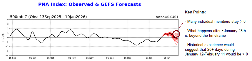
-
2025-2026 ENSO
donsutherland1 replied to 40/70 Benchmark's topic in Weather Forecasting and Discussion
Yes. It has been uneven. Then again, it hasn’t been a strong La Niña event. -
Be careful. MJO812 may use this as evidence to arrest you for theft of digital snow. That's a grave crime during a period of years with below and much below normal snowfall.
-
2025-2026 ENSO
donsutherland1 replied to 40/70 Benchmark's topic in Weather Forecasting and Discussion
Angular Atmospheric Momentum (AAM) is a good tool for determining how well coupled the atmosphere is with ENSO. AAM measures how fast the atmosphere is spinning around the Earth, which is mainly a function of the strength and latitude of the westerly winds. El Niño is characterized by stronger westerly winds. AAM+ indictates stronger westerly winds. La Niña is characterized by weaker westerly winds/easterly winds. AAM- indicates weaker westerly winds/more easterly winds. Despite social media chatter that the atmosphere is not coupled with the ongoing La Niña event, the AAM showed otherwise. That the forecast AAM has also shifted negative shows that claims that La Niña is on its death bed, so to speak, are premature. La Niña is fading in discontinuous fashion and subsurface warming is starting to occur. But La Niña is not collapsing, much less essentially finished. On its current trajectory, neutral-cool conditions could develop toward the end of this month or next month. -
2025-2026 ENSO
donsutherland1 replied to 40/70 Benchmark's topic in Weather Forecasting and Discussion
I suspect that the recent EWB had an impact. La Niña is still exerting an influence. -
March 1-2, 1980 might have an intellectual property claim against the AIFS.
-
Through tomorrow, highs will generally reach the 40s during the daytime and 30s for lows in New York City. Some light precipitation is possible tomorrow evening into Thursday. Rain showers could transition to a period of snow or snow showers, especially well north and west of New York City where a light accumulation is possible. Afterward, temperatures will "step down" with highs mainly in the middle and upper 30s in New York City and lows in the lower and middle 20s. Some teens are likely outside of New York City. Flurries and perhaps a heavier snow shower are possible on Saturday and Sunday as a renewed flow of cold air moves across the region. Temperatures will remain below normal through at least early next week. After January 20th, conditions might become more favorable for both cold and snowfall, especially if the PNA remains predominantly positive, as has often occurred following the breakdown of long-duration PNA- regimes. PNA-related developments would have larger implications for snowfall. A persistently positive PNA would have above climatological risk of moderate or significant snowfalls. A mainly negative PNA would favor mainly small snowfalls. It will likely be another day or two before the guidance reaches the high-skill timeframe for teleconnection forecasts related to closing days of January. The ENSO Region 1+2 anomaly was -0.7°C and the Region 3.4 anomaly was -0.8°C for the week centered around January 7. For the past six weeks, the ENSO Region 1+2 anomaly has averaged -0.47°C and the ENSO Region 3.4 anomaly has averaged -0.67°C. La Niña conditions will likely continue into at least late winter. The SOI was +8.91 today. The preliminary Arctic Oscillation (AO) was -0.667 today. Based on sensitivity analysis applied to the latest guidance, there is an implied near 58% probability that New York City will have a cooler than normal January (1991-2020 normal). January will likely finish with a mean temperature near 33.3° (-0.4° below normal). Supplemental Information: The projected mean would be 0.7° above the 1981-2010 normal monthly value.
-
2025-2026 ENSO
donsutherland1 replied to 40/70 Benchmark's topic in Weather Forecasting and Discussion
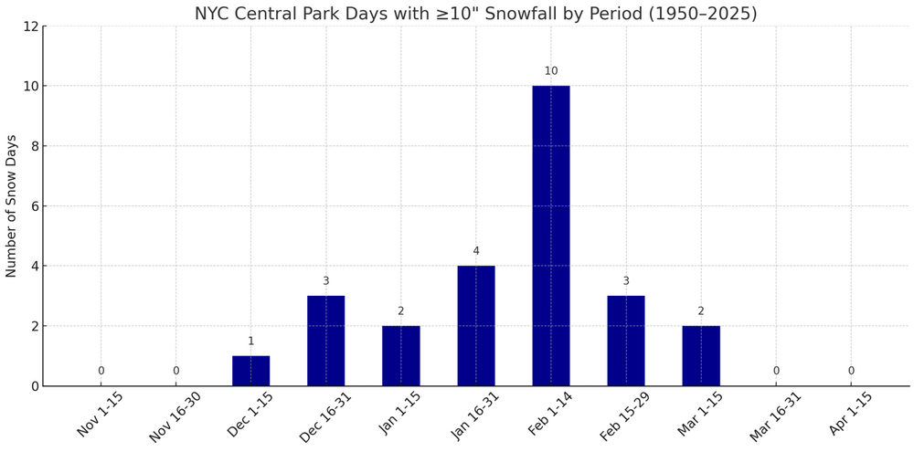
Historically, about 30% of winters with similar or less snowfall than 2025-2026 through January 12th went on to see 25" or more snow. My thinking coming into this winter was 15"-25". I still think that's realistic. In any case, here's the historical data for Central Park.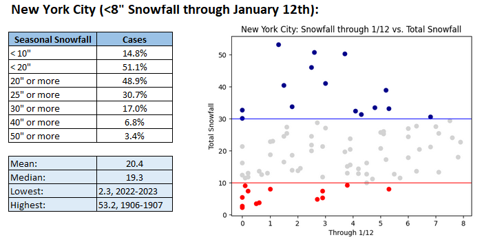
-
Here's how New York City has fared when it has had less than 8" of seasonal snowfall through January 12th (n=88 cases). The 2025-2026 figure through January 12th is 7.7".
-
2025-2026 ENSO
donsutherland1 replied to 40/70 Benchmark's topic in Weather Forecasting and Discussion
This morning's preliminary value of the PNA was +0.707. That's the highest the PNA has been since November 20, 2025 when the PNA reached +0.738. The PNA will remain positive for several more days before it is forecast to go somewhat negative for a short period of time. Afterward, the GEFS show the PNA rebounding. It remains plausible that a regime change (20+ days where the PNA>0 during the January 12-February 11 period or the 30-day period following the end of the recent long-duration PNA- regime) can occur. If so, perhaps the best opportunity for a moderate or larger snowstorm in the Middle Atlantic Region or Northeast could be in the January 25-February 15 timeframe. For such potential to be realized, the synoptic pieces would need to become available. So far, the subtropical jet has been largely quiet this winter. Should the forecast strong WWB materialize, that could lead to the subtropical jet's becoming more active across the southern tier of the U.S. some 10-14 days later. Whether that would align during a favorable longwave pattern remains to be seen. In the near-term, lighter snows are likely in parts of the Great Lakes Region and Northeast. The lake effect belts could see greater snowfalls, especially as Arctic air could try to get involved next week. -
2025-2026 ENSO
donsutherland1 replied to 40/70 Benchmark's topic in Weather Forecasting and Discussion
I have a list of Southeast Region snowstorms and just checked the dates last night. The date range is where the Southeast was receiving snow.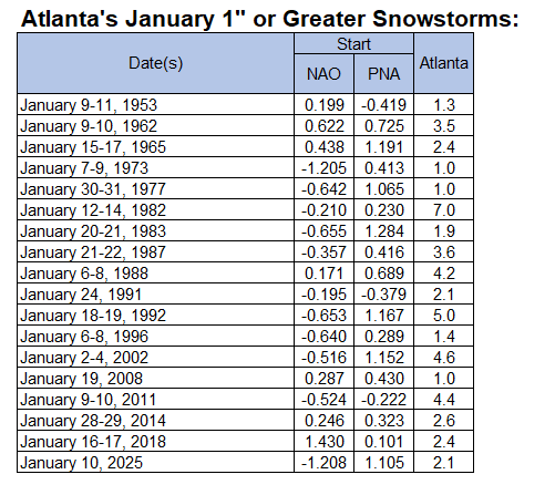
-
2025-2026 ENSO
donsutherland1 replied to 40/70 Benchmark's topic in Weather Forecasting and Discussion
Yes, the PNA is far more important to Atlanta's January snowstorms than the NAO. Since 1950, the PNA was positive for 84.2% of Atlanta's 1" or greater snowstorms. The NAO was negative for 63.2% of such storms. -
Bridgeport, Islip, Central Park, JFK Airport, LaGuardia Airport, and White Plains all had highs of 41F (5.0C) today. If that holds, it would be the first time since November 21, 1998 that all six locations had identical high temperatures.
-
Through Wednesday, highs will generally reach the 40s during the daytime and 30s for lows in New York City. Somewhat colder readings are likely outside the City and in areas where strong radiational cooling takes place. After the middle of next week, temperatures will "step down" with highs mainly in the middle and upper 30s in New York City and lows in the middle and upper 20s. Some light precipitation is possible on Friday. Rain showers could transition to a period of snow. A light accumulation is possible. Some additional precipitation could arrive on Sunday. No significant Arctic blasts or significant snowfalls are likely through at least mid-January. Afterward, conditions might become more favorable for both cold and snowfall, especially if the PNA remains predominantly positive, as has often occurred following the breakdown of long-duration PNA- regimes. PNA-related developments would have larger implications for snowfall. A persistently positive PNA would have above climatological risk of moderate or significant snowfalls. A mainly negative PNA would favor mainly small snowfalls. It will likely be another day or two before the guidance reaches the high-skill timeframe for teleconnection forecasts. The ENSO Region 1+2 anomaly was -0.7°C and the Region 3.4 anomaly was -0.8°C for the week centered around January 7. For the past six weeks, the ENSO Region 1+2 anomaly has averaged -0.47°C and the ENSO Region 3.4 anomaly has averaged -0.67°C. La Niña conditions will likely continue into at least late winter. The SOI was +12.16 today. The preliminary Arctic Oscillation (AO) was -1.040 today. Based on sensitivity analysis applied to the latest guidance, there is an implied near 55% probability that New York City will have a cooler than normal January (1991-2020 normal). January will likely finish with a mean temperature near 33.5° (-0.2° below normal). Supplemental Information: The projected mean would be 0.9° above the 1981-2010 normal monthly value.
-
PSV88, Rest assured, I have a thick skin. I don't take it personally. I hope he also remains here, too.
-
For those who want a highly simplified but easy-to-understand description of sensitivity analysis, one can reference the following: https://thedecisionlab.com/reference-guide/statistics/sensitivity-analysis. And for those who want insight into the estimated probability, applying multiple variations to the model value, assessing the probability against a benchmark (1991-2020 normal value) using a normal distribution.


