

donsutherland1
-
Posts
23,988 -
Joined
Content Type
Profiles
Blogs
Forums
American Weather
Media Demo
Store
Gallery
Everything posted by donsutherland1
-
Storm potential January 17th-18th
donsutherland1 replied to WeatherGeek2025's topic in New York City Metro
Preliminary snowfall amounts: Central Park: 1.0” JFK Airport: 0.6” LaGuardia Airport: 1.4” Newark: 2.0” -
QPF amounts in New York City were in line with the guidance with 0.17" being recorded. Both the NBM and ECMWF fared best. However, 0.16" fell over a 2-hour period rather than the 3-4 hour spread that had been shown on the guidance. On account of the heavier rates, temperatures dropped to the wet bulb temperature (32°) during the height of the precipitation rather than the above freezing figures that had been shown on the guidance.
-
Storm potential January 17th-18th
donsutherland1 replied to WeatherGeek2025's topic in New York City Metro
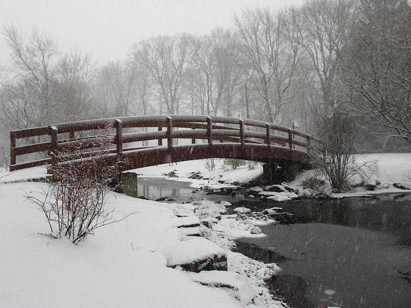
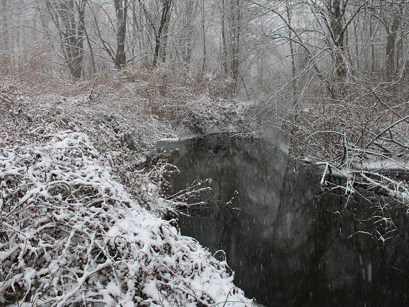
Three photos from Armonk, NY: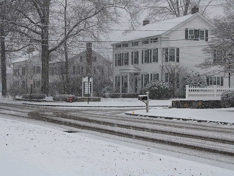
-
Storm potential January 17th-18th
donsutherland1 replied to WeatherGeek2025's topic in New York City Metro
It will probably be closer to 7-8:1, which is much better than what would have been the case had the precipitation been lighter. Outside the City, things are on course and some areas could see ratios near 10:1. -
Storm potential January 17th-18th
donsutherland1 replied to WeatherGeek2025's topic in New York City Metro
Today is a nice overperformer. NYC saw 0.09" precipitation in the past hour and that sent the temperature all the way down to the wet bulb figure of 32°. -
Storm potential January 17th-18th
donsutherland1 replied to WeatherGeek2025's topic in New York City Metro
Armonk, NY: -
Storm potential January 17th-18th
donsutherland1 replied to WeatherGeek2025's topic in New York City Metro
Snowing lightly in Scarsdale. -
Storm potential January 17th-18th
donsutherland1 replied to WeatherGeek2025's topic in New York City Metro
Graupel in Larchmont with a dusting. -
Storm potential January 17th-18th
donsutherland1 replied to WeatherGeek2025's topic in New York City Metro
The models began shifting at the 0z cycle and continued through 6z. -
Storm potential January 17th-18th
donsutherland1 replied to WeatherGeek2025's topic in New York City Metro
The 1/17 0z NBM forecast a 12z temperature of 34° for Central Park. The actual figure was 37°. With temperatures likely to run between 36°-38° when the main batch of precipitation arrives vs. the previously modeled 33°-35°, little or no snow accumulation is likely in and around New York City. The City's northern and western suburbs are in line for a coating to an inch of snow with the distant northern and western suburbs likely to see 1"-2" with some locally higher amounts. Much of the overnight guidance has shifted toward a solution of a closer coastal low. As a result, a period of accumulating snow with 1"-2" possible in and around New York City. Eastern Long Island into southeastern New England appear to likely to see 2"-4" with perhaps some higher amounts. There remains some uncertainty concerning the developing storm's track and rate of development. Arctic air will begin to overspread the region on Monday and Monday night. -
2025-2026 ENSO
donsutherland1 replied to 40/70 Benchmark's topic in Weather Forecasting and Discussion
They should do better this time. -
Storm potential January 17th-18th
donsutherland1 replied to WeatherGeek2025's topic in New York City Metro
With the temperature now up to 36 in Central Park, only a trace of snow is the most likely outcome today. A coating is a lower probability. -
2025-2026 ENSO
donsutherland1 replied to 40/70 Benchmark's topic in Weather Forecasting and Discussion
I don’t know. It wouldn’t surprise me if it’s temporary. -
2025-2026 ENSO
donsutherland1 replied to 40/70 Benchmark's topic in Weather Forecasting and Discussion
The potential warmup shows up quite prominently on the Week 3 guidance:
-
Snow showers or a period of snow is likely tomorrow. A coating to an inch of snow is likely in and around New York City, as readings will likely be above freezing for most or all of the event. The precipitation could mix with or even change to rain in New York City. Total QPF will probably be close to 0.20". The distant northern and western suburbs could see 1"-2" of snow with some locally higher amounts due to slightly higher QPF and slightly colder temperatures. Highs will likely reach the upper 30s to near 40°. It will then turn colder following the light precipitation. Additional flurries or snow showers are possible on Sunday. A coastal storm could begin to develop off the Southeast coast and then track south and east of the 40N-70W benchmark. On such a track, this developing storm could bring a period of accumulating snow to eastern Long Island into southeastern New England on Sunday into Sunday night. There remains a degree of uncertainty concerning the storm's track and rate of development. Highs will be mainly in the lower and middle 30s in New York City on Sunday and Monday. Arctic air will move into the region on Monday night. Tuesday could be the coldest day so far this season with highs struggling to reach the lower 20s and lows well into the teens in New York City. Suburban areas could see single-digit lows. Wednesday will be another unseasonably cold day. Temperatures will remain below normal through at least most of next week. After January 20th, conditions could become more favorable for snowfall, as a generally cold pattern continues. The probability of a PNA+ regime has continued to increase. PNA-related developments would have large implications for snowfall. A persistently positive PNA would have above climatological risk of moderate or significant snowfalls. A mainly negative PNA would favor mainly small snowfalls. The ENSO Region 1+2 anomaly was -0.7°C and the Region 3.4 anomaly was -0.8°C for the week centered around January 7. For the past six weeks, the ENSO Region 1+2 anomaly has averaged -0.47°C and the ENSO Region 3.4 anomaly has averaged -0.67°C. La Niña conditions will likely continue into at least late winter. The SOI was +21.96 today. The preliminary Arctic Oscillation (AO) was -1.350 today. The PNA was +0.965. That's its highest figure since November 2, 2025 when it was +1.071. Based on sensitivity analysis applied to the latest guidance, there is an implied near 62% probability that New York City will have a cooler than normal January (1991-2020 normal). January will likely finish with a mean temperature near 33.0° (-0.7° below normal). Supplemental Information: The projected mean would be 0.4° above the 1981-2010 normal monthly value.
-
It increasingly looks like there could be some more impressive hourly snowfall rates in parts of northeast PA into Orange County. That's probably where most of the amounts closer to 4" could show up. I suspect amounts closer to 2" maybe 3" are likely in Passaic and Putnam Counties.
-
Storm potential January 17th-18th
donsutherland1 replied to WeatherGeek2025's topic in New York City Metro
Same in Larchmont. -
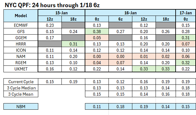
The 12z guidance has moved into strong agreement concerning the QPF for tomorrow's light precipitation event with only the UKMET and ECMWF left to initialize. The NAM is a notable dry outlier for New York City (0.01"). The RRFS A, the NAM's successor model, has 0.20" QPF. With the NAM doing NAM things in the face of strong agreement among the other guidance, the idea that New York City will see little or no precipitation is discounted. Snowfall amounts in New York City will still be limited: Readings will likely be above freezing for most or all of the event. Readings will generally range from 33°-34° during the event. QPF will be on the light side (probably 0.15"-0.25"). The 15z NBM has 0.20". Most of the 12z guidance is just under 0.20". Precipitation rates in the City will likely be less than 0.05" per hour except for a brief period. Measurable snow is likely in Central Park. There's strong agreement among the individual EPS members for this outcome. All of the 12z guidance, except for the NAM, shows measurable snow. All said, snow showers or a period of snow remains likely tomorrow. A coating to an inch of snow is likely in and around New York City. The distant northern and western suburbs could see 1"-2" of snow due to slightly higher QPF, precipitation rates, and slightly colder temperatures. Sunday still bears some watching, as uncertainty is somewhat greater than it is for tomorrow. The Canadian suite (GGEM-RGEM) continue to bring a light measurable snowfall to New York City and its adjacent suburbs. The earlier runs of the ECMWF keep the snows farther east. As the GGEM is consistently the #2 rated model, it's solution is plausible. There was very little support for accumulating snowfall in New York City among the 1/16 0z EPS members. Therefore, at least for now, a miss to the east still remains more likely than not. Under that baseline scenario, there would be some accumulating snow in eastern Long Island into southeastern New England. Snow flurries and/or snow showers would be possible farther west, including in the New York City area.
-
2025-2026 ENSO
donsutherland1 replied to 40/70 Benchmark's topic in Weather Forecasting and Discussion
My confidence that we are in the early stages of what will be a regime change to a predominantly positive PNA since the end of the PNA- regime on January 11th has increased. The latest guidance shows most of the days will be positive through at least January 26. The regime change is consistent with historic experience following 25-day or longer PNA- regimes during winter.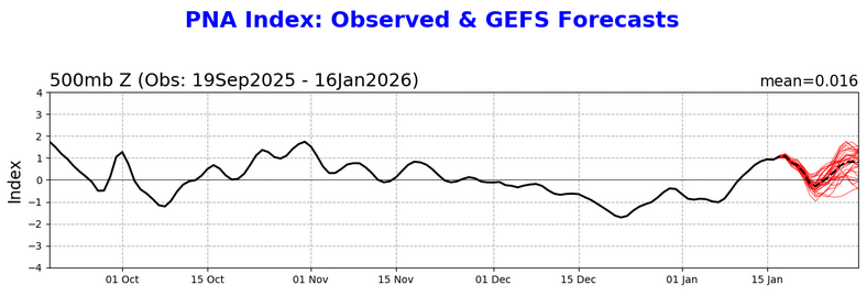
-
Storm potential January 17th-18th
donsutherland1 replied to WeatherGeek2025's topic in New York City Metro
I suspect that it will take a change on the ECMWF to shake up the current thinking. The 6z GFS might be a plausible "best case" (if one likes snow). None of last night's EPS members had anything like it, though. A single member had 3" in NYC. The 0z RGEM had something similar though it backed off somewhat at 6z. There's just enough support on the guidance to suggest a snowier solution remains possible. Maybe the AI models will come out on top. Hopefully, over time, the AI models will improve their skill and become an important forecasting tool. -
If the models can continue to hold the frontogenic signature, I'll be more enthusiastic about it. I do think the Hudson Valley can wind up with 1"-2" amounts (colder readings), but the City and nearby suburbs still looks like a coating to an inch. I agree about the uncertainty regarding CT, lower Hudson Valley, and central NJ. The models are still jumping around with the QPF (the 0z GFS was probably an outlier with almost 0.40"). A realistic ceiling for the City is probably around 0.30", as fewer than 20% of EPS members have 0.30" or more. The ceiling might be somewhat higher in the areas you highlighted for banding. Finally, we agree that NYC will have a minimum temperature below 33° (probably 30°-31° very early), but most of the precipitation will likely fall when the temperature is 33°-34°. I used the 33° minimum as a proxy because most or all of the precipitation will fall with above freezing temperatures. That still hasn't changed on the overnight guidance.
-
2025-2026 ENSO
donsutherland1 replied to 40/70 Benchmark's topic in Weather Forecasting and Discussion
IMO, this isn't surprising. It was always a stretch to suggest that the La Niña would almost instantaneously disappear and that all of its influence would disappear along with it. I'm unimpressed with most of the social media forecasters. But for now, I have to get out the snow blower, if I have any hope of getting to work. Roads must be snowed in, cars buried, and the landscape smothered under a thick blanket of drifted snow. Oh wait, the sky is crystal clear and the sun is shining brightly. The ground is barren.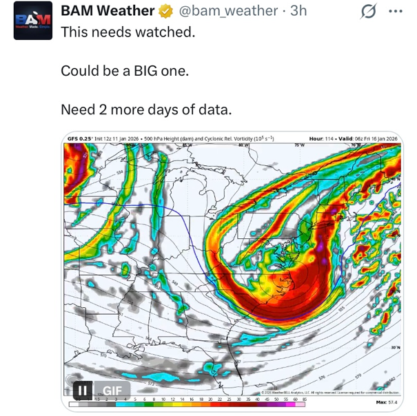
-
Through the 1/16 0z HRRR and NAM, it still appears that there will be some flurries, snow showers, or some periods of snow on Saturday. The temperature will likely be above freezing during much or all of the snowfall. In addition, total precipitation will likely be under 0.20" and precipitation rates will be light. As such, the more aggressive model output is likely overdoing the snowfall in and around New York City. Since recordkeeping began, there have been just nine January snowfalls of 1" or more with a minimum temperature of 33° or above. The lowest precipitation for these storms was 0.23". All but one saw 0.50" or more precipitation. Therefore, any accumulations should be light (mainly a coating to an inch).
-
Storm potential January 17th-18th
donsutherland1 replied to WeatherGeek2025's topic in New York City Metro
My concern about Saturday is that temperatures in and around NYC will probably be around 34° during the snowfall. Even a GFS-esque burst of snow could result in a coating rather than several inches at such temperatures. That's why my current thinking is a coating to an inch. If temperatures could be a degree or two cooler, it would be easier for the snow to accumulate. -
2025-2026 ENSO
donsutherland1 replied to 40/70 Benchmark's topic in Weather Forecasting and Discussion
I suspect that the UHI Effect plays a role. The dandelions aren't exposed for the kind of long periods to severe cold that they are in colder less urban areas.


