frd
-
Posts
7,028 -
Joined
-
Last visited
Content Type
Profiles
Blogs
Forums
American Weather
Media Demo
Store
Gallery
Everything posted by frd
-
Not the first time strong highs up North did not funnel in colder air to our region. However, maybe that will change with future model runs, as snow cover is increasing up North while the NAO is not going crazy positive.
-
Fits @psuhoffman analog set for this coming winter. Expect the cold, but most were not snowy years.
-
Having a decent source region is something we have lacked for a long time. Also, SE Canada is going to have a large increase in snow cover over the next couple weeks.
-
The most you can determine might be a favorable window. Not too mention, but a Nina with an active Northern jet is extremely difficult to model in the long range. Expect the unexpected.
-
In past Decembers when it was cold, we tended not to cash in on the cold. However, the chill will lend to the holiday season. There is still potential beyond the 10 day period, I like the window from Dec. 7 th to the 10 th.
-
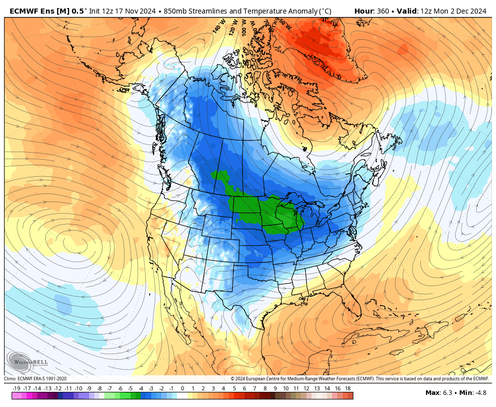
This image looks like the XXX weather model porn we had this past Jan., which was showing an historic cold and snow pattern for the East. Ironic, if this December delivers cold and snow when most had little hopes for this winter, let alone December which tyically is not our climo peak. Time will tell.
-
Trends continue for the late month transition to much colder, and possibly active as well.

-
Totals going down.
-
Thought Ninas were front loaded.
-
Very close to my area obs
-
Checked temps at 11:00 PM , 2:00 AM and 6:00 AM - seems coldest part of the night was near 3:00 AM here, then temps went up at several nearby stations. No hard freeze here and minor frost. Low was 31 degrees at near 3: 00 AM I believe.
-
2024 Mid-Atlantic Garden, Lawn, and Other Green Stuff Thread
frd replied to mattie g's topic in Mid Atlantic
@CAPE doing anything tonight due to the possible freeze , as in protecting your new grass, or is it established now ? Some folks were talking about watering the lawn at sunset tonight which add 2 to 4 degrees of heat to the grass canopy reducing the odds of killing grass seedlings. I believe I read once new grass is over 3 inches, and has been mowed twice, that 30 degrees F is not an issue, ( some ag folks say even 20 degrees F is not an issue ) meanwhile root growth continues into December. -
Surprised to see that.
-
Low of 37 degrees here. Noticed the ground at the large school campus I take my greyhound to is extremely hard, due to soil moisture level currently at 17.62%. Can not remember is being so dry, even for October in these parts for many, many years.
-
-
Each year Fall late summer weather extends deeper in November, and at times December. Nothing new this year. Ocean temps still near 67 F. Beach weather next week. SE may set some records with warmth possible along the ring of the WAR.
-
37 here.
-
Soil moisture is truly extreme near 17.8 % Overseeding this year has been very difficult. The month as a whole looks very dry.
-
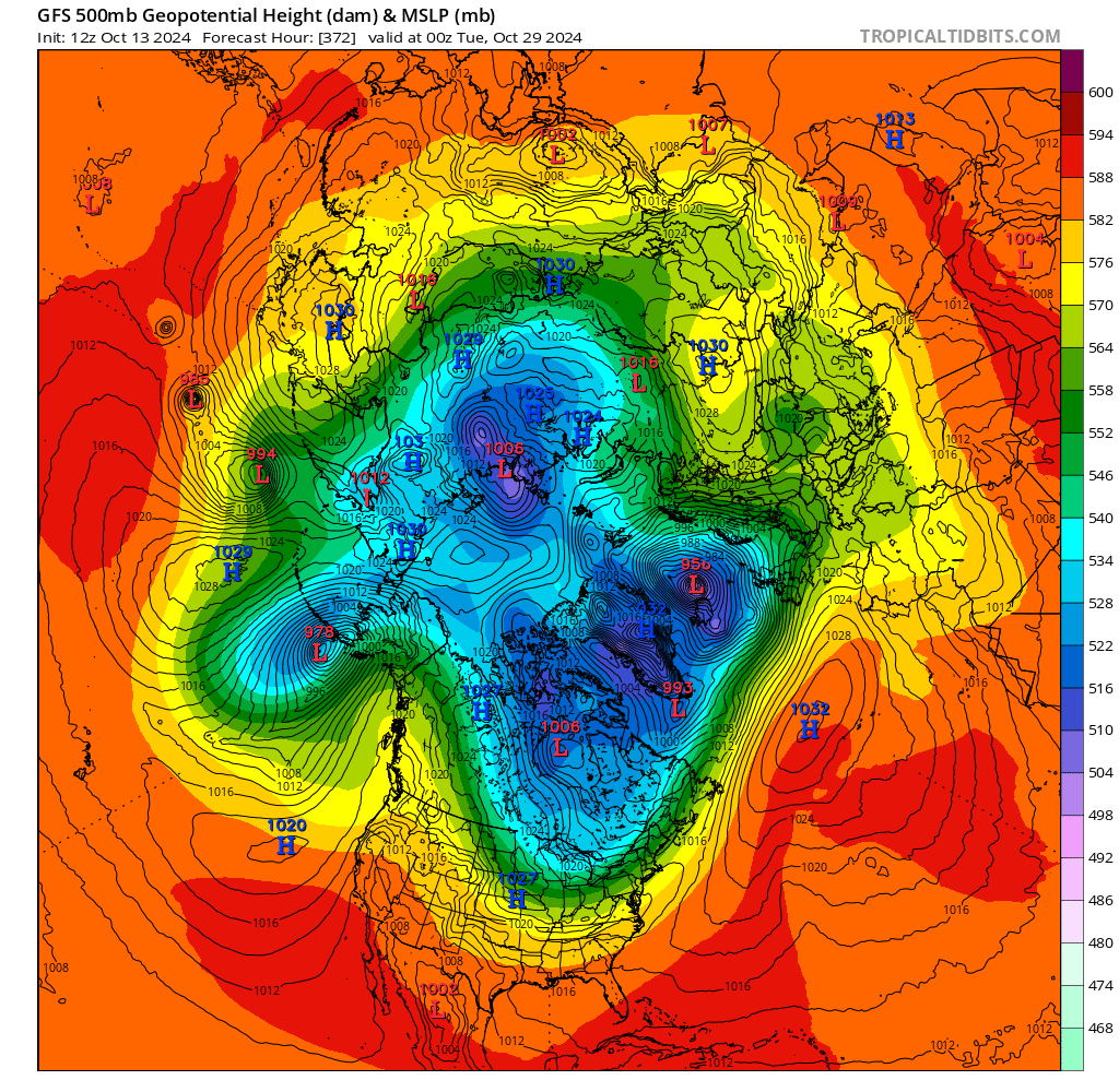
Interesting look over the NH. for later in the month. Seems it fits the early season Nina look, then we warm in January unless the -WPO guides the - EPO. I imagine one more beach trip prior to this colder change.

-
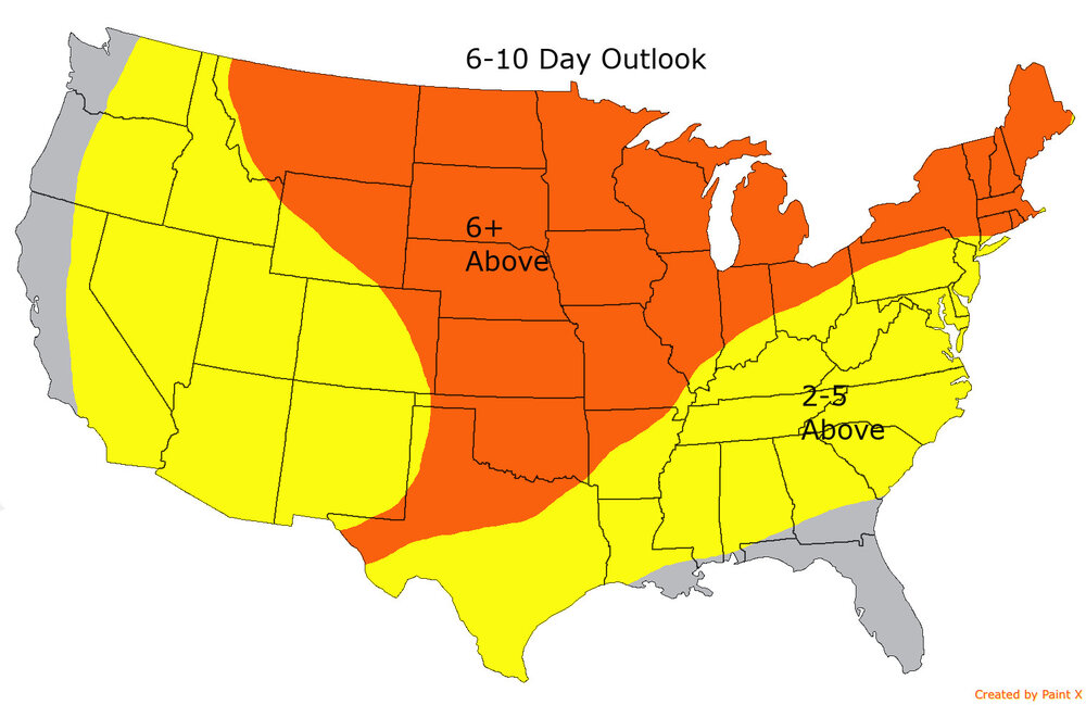
Central and Eastern Canada to get a little closer to normal if true
-
The news anchors in this area ( WPVI channel 6 and NBC New 10 ) always chime in after the weather forecast person is done and proudly states well we needed the rain. What rain ? Its been cloudy for the past 8 days but with hardly any measurable rain in this part of the forecast area.
-
Love the concensus for my area.
-
-
Clearing line steadily moving NE. Might make it to Middletown DE. Seeded might need to water.