frd
-
Posts
7,028 -
Joined
-
Last visited
Content Type
Profiles
Blogs
Forums
American Weather
Media Demo
Store
Gallery
Everything posted by frd
-
January: Medium/ Long Range: May the Force be with Us....
frd replied to Weather Will's topic in Mid Atlantic
Crazy snow loop by Tomer https://x.com/burgwx/status/1873154546278776971 -
January: Medium/ Long Range: May the Force be with Us....
frd replied to Weather Will's topic in Mid Atlantic
Inland runner, we need to break the curse here. The past 6 winters have fetaured a combination of coastal scrappers, inland runners and cutters, resulting in crumbs for the lowlands. Well, with a minor exception, or two. Time to move on in the New Year . -
January: Medium/ Long Range: May the Force be with Us....
frd replied to Weather Will's topic in Mid Atlantic
What a drastic change. Several ongoing elements such as the SSWE , - NAM state, favorable MJO, and Changes in the PDO. I have heard some mets talking about the cold transitioning to the West by late Jan. Weeklies show different outcome. Ah...the love of weather! -
January: Medium/ Long Range: May the Force be with Us....
frd replied to Weather Will's topic in Mid Atlantic
https://x.com/MikeTFox5/status/1873079254445178916 Mike Thomas @MikeTFox5 Good news is that the new afternoon European Ensembles still showing everything you want them to show for a mid-range forecast. Also showing a pretty darn decent nor’easter signature around the 9th. Devil’s always in the details though. Still looks like some very exciting times ahead to me That’s it for the 12z runs! More updates later with the 0z cycle! -
January: Medium/ Long Range: May the Force be with Us....
frd replied to Weather Will's topic in Mid Atlantic
Appears the Jan 8th - Jan 10 th system in the Southern Plains , then in the northern Gulf then cruising across Fla. on the Euro OP. Lets see the EPS next GEFS as @CAPE posted above looks a million times better. -
January: Medium/ Long Range: May the Force be with Us....
frd replied to Weather Will's topic in Mid Atlantic
Or a Manitoba Mauler -
January: Medium/ Long Range: May the Force be with Us....
frd replied to Weather Will's topic in Mid Atlantic
With this look have to think hard about snow chances, seems to be a massive push of arctic cold way South, and with it any hopes for snow . -
January: Medium/ Long Range: May the Force be with Us....
frd replied to Weather Will's topic in Mid Atlantic
Too cold not good -
January: Medium/ Long Range: May the Force be with Us....
frd replied to Weather Will's topic in Mid Atlantic
1-19-85 1-9-77 1-12-2016 12-23-09 -
January: Medium/ Long Range: May the Force be with Us....
frd replied to Weather Will's topic in Mid Atlantic
Totally agree. MJO even looks decent, along with a weaker PV and expanding snow cover over NA to provide less moderation at temps, all happening at a time of still low solar output. -
January: Medium/ Long Range: May the Force be with Us....
frd replied to Weather Will's topic in Mid Atlantic
Looking at North America, and even NW of Alaska there is no shortage of disturbances moving SE to feed into the massive cold pool over the East. -
January: Medium/ Long Range: May the Force be with Us....
frd replied to Weather Will's topic in Mid Atlantic
OMG all of these index forecasts keep looking better every day, crazy !!! -
January: Medium/ Long Range: May the Force be with Us....
frd replied to Weather Will's topic in Mid Atlantic
I am getting a boat and heading East, way East. This representation is meh for the low lands all along the East Coast. And, yes I know Thinking this trends better over time. Should be a cycle of storms from offshore trending to more typical SECS, analogs will be telling as well. -
January: Medium/ Long Range: May the Force be with Us....
frd replied to Weather Will's topic in Mid Atlantic
https://x.com/RyanMaue/status/1872828840109867239 Checking on the AIFS 18z ... unloads everything on the Eastern U.S. Still 10-12 days away, but unless/until something changes with all of the models, we're looking at a severe cold snap in Jan 8-11 windows. -
January: Medium/ Long Range: May the Force be with Us....
frd replied to Weather Will's topic in Mid Atlantic
Snow into Florida, ensures snow in our region. -
January: Medium/ Long Range: May the Force be with Us....
frd replied to Weather Will's topic in Mid Atlantic
Of interest https://x.com/MikeTFox5/status/1872804772027285756 A note of caution...the analog patterns centered on the 9th are not the most snow heavy in the world for DC. Of the 10 listed, only four had above 5" of snow in January. 1981 - 4.2" 2001 - 2.7" 2007 - 1.3" 2002 - 4.5" 1980 - 8.6" 1985 - 10.0" 1977 - 10.3" 2017 - 1.4" 2018 - 1.2" 2010 - 7.4" So the "it's cold but the storms just don't line up for DC" scenario is of course, on the table. But still, it's hard not to be excited for the pattern ahead. None of the analog years had NO snow, and I'm doubtful we get through the first 2/3 of January without getting SOMETHING to stick on the ground. Just not sure if that means a blizzard, or more of a less memorable but still disruptive snow. Time will tell...(8/) -
January: Medium/ Long Range: May the Force be with Us....
frd replied to Weather Will's topic in Mid Atlantic
You think this continues to trend better this weekend into next week? -
January: Medium/ Long Range: May the Force be with Us....
frd replied to Weather Will's topic in Mid Atlantic
I like -
January: Medium/ Long Range: May the Force be with Us....
frd replied to Weather Will's topic in Mid Atlantic
If the EPS ic correct at range, cold air should not be an issue. Coldest early Jan since 2018 possibly. -
January: Medium/ Long Range: May the Force be with Us....
frd replied to Weather Will's topic in Mid Atlantic
Nothing remarkable there, just climo. I would focus on the trends starting this weekend for Jan 7 th to Jan 15 th. -
January: Medium/ Long Range: May the Force be with Us....
frd replied to Weather Will's topic in Mid Atlantic
Always appreciate your input. We all strive to have a cup 1/2 full mentality. With my recent loss of a loved one, I too might be looking less excited about snow potential and other things in life too. Recent modeling still looks good for us snow lovers. At least we are I the game. I take that any day. -
January: Medium/ Long Range: May the Force be with Us....
frd replied to Weather Will's topic in Mid Atlantic
Dry was always a concern. Seasonal models predicted subnormal precip. We only get dumped on during the transition period to cold. Which is rain. It's a bummer. -
January: Medium/ Long Range: May the Force be with Us....
frd replied to Weather Will's topic in Mid Atlantic
Rather intense Davis Straits block depicted there. Pretty cool look. -
January: Medium/ Long Range: May the Force be with Us....
frd replied to Weather Will's topic in Mid Atlantic
+PNA more associated with SECS , is that correct Chuck ? -
January: Medium/ Long Range: May the Force be with Us....
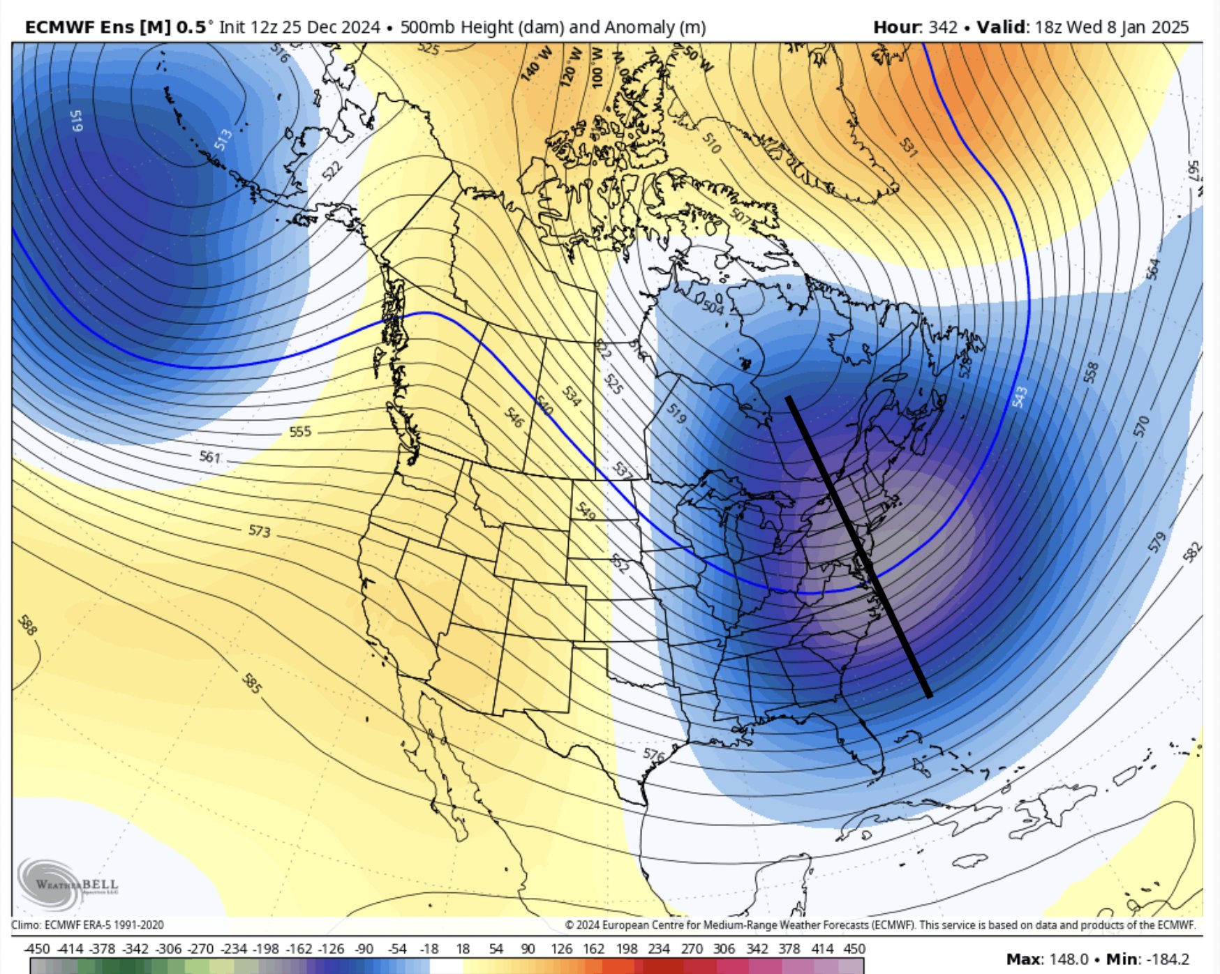
frd replied to Weather Will's topic in Mid Atlantic
https://x.com/ryankanerWX/status/1872004512376127920 Appears that the EPS with trough axis too far East, even at hour 342, hopefully things change in future runs, if not might just end up with very cold and dry conditions, storms way offshore of the Mid Atlantic and even the NE.