BlizzardNole
-
Posts
2,947 -
Joined
-
Last visited
Content Type
Profiles
Blogs
Forums
American Weather
Media Demo
Store
Gallery
Everything posted by BlizzardNole
-
Big Heat (and storms?) Week into July 4th Weekend
BlizzardNole replied to yoda's topic in Mid Atlantic
My point/click was 105 for Thursday and Friday, which I have never seen before! Now it's 102 which is probably more realistic If folks in OC MD for the week can get a S wind off the ocean, they are getting their money's worth! Maybe 89 or 90 for highs? -
Sounds nice! I gave up a few weeks ago and will try again in September. I want a natural looking lawn with lots of clover, a few wildflowers, etc, 0.20 final total for the event
-
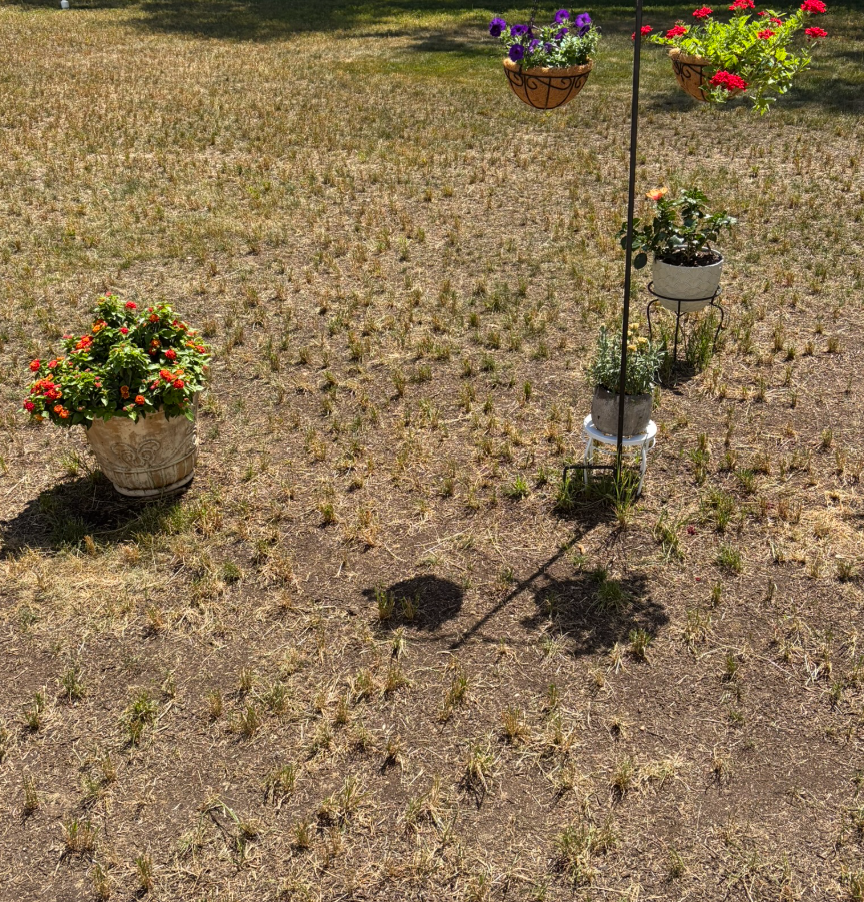
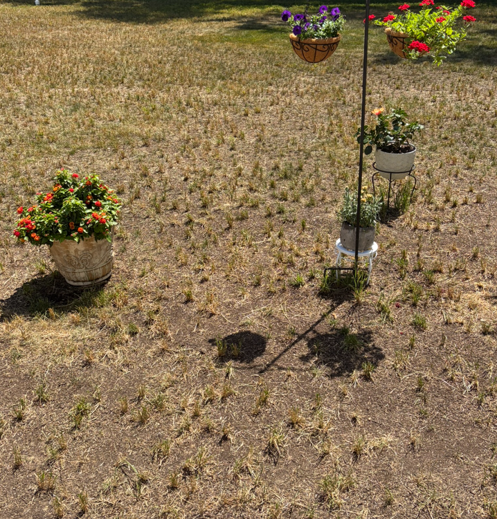
Here's my actual yard, including pathetic garden attempt
-
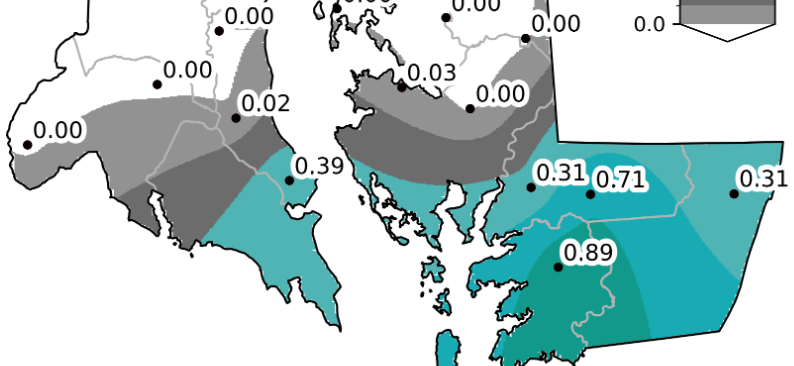
Oh I think we hit exceptional for sure after July and Aug both less than 1.0 total rainfall and many 100-degree days
-
Yup! I've been saying that along with continuing extreme drought, we'll have 15 or more 95-plus days, five 100-plus and one 105. I might be low on those!
- 259 replies
-
- 1
-

-
- we got burned
- rugpull central
- (and 1 more)
-
A big 0.2 for me, and the forecast has been walked back to just scattered light showers. That 0.2 is probably my total. Then we descend into 100-plus degree hell this week
-
This is gonna be such a brutal summer. I'm thinking 15 or more 95-degree days, five 100s, and one 105. Very little rainfall too. I think many of us will be happy when fall gets here. Filtered sun and 80/67
-
We'll see. Yesterday afternoon looked great on paper with LWX highlighting Calvert and St. Mary's for heavy rain potential, and I got a quarter inch. My area has a departure of -8 inches for the year and would need rainfall of 150% to 200% of normal for four straight months to recover.
-
New thread would be good so I can track my next quarter inch deluge
- 259 replies
-
- 3
-

-
- we got burned
- rugpull central
- (and 1 more)
-
Wet late Monday 6/22 or another Fizzle?
BlizzardNole replied to Weather Will's topic in Mid Atlantic
0.9 total for the "event" and on the way to my prediction of 3 inches total for Jun-Jul-Aug combined, along with 15 or more days of 95-plus -
Wet late Monday 6/22 or another Fizzle?
BlizzardNole replied to Weather Will's topic in Mid Atlantic
Just 0.23 for today and it looks to be done. Pretty disappointing given expectations -
Finally able to enjoy sitting on the screened porch with a steady, moderate rain. I hope it goes all afternoon. Temp a moist 68
-
Wet late Monday 6/22 or another Fizzle?
BlizzardNole replied to Weather Will's topic in Mid Atlantic
This from LWX disco sounds really good! It would be awesome to get 1" here on top of the 0.65 from last night Locally heavy rainfall is likely over southern Maryland, particularly across Calvert and St. Mary`s Counties. In those counties, 3+ inch rainfall totals in a short period of time are possible which could lead some localized flooding in those areas. -
Wet late Monday 6/22 or another Fizzle?
BlizzardNole replied to Weather Will's topic in Mid Atlantic
0.65 at the mesonet a couple miles from me which is great given how parched we are down here. I hope we can luck into some more tomorrow morning -
Wet late Monday 6/22 or another Fizzle?
BlizzardNole replied to Weather Will's topic in Mid Atlantic
Gimme that! I don't want severe. I'd love to see multiple rounds including some after dark with lightning and long, rolling thunder. -
Glad for far southern Calvert, St Marys and the eastern shore - they needed something bad. None for me though (unless I count the 0.02 LOL)
-
We're in a new construction home which means trying to start a lawn. I gave up and will try again this fall. As for garden, I just have a few containers and pots I can water. I think we'll see a wet and mild winter which would help getting a lawn going. Cloudy 71/68
-
And, it failed. Next chance is Monday and I'm wondering - does that miss us north or south?
-
Was hoping for t-storms here in the Extreme Drought area, but nothing. What a devastating summer awaits us. Less than 3" total rainfall for June-Aug. 15-20 days of 95-plus temps with multiple 100-degree days. Please October get here ASAP
-
Raleigh area in Exceptional. We might be there by next month
-
I saw the cloudy sky and looked at radar -- congrats northern MD! Maybe I'll luck into a t-storm later today. I'm hoping next Monday turns into a real soaker.
-
This is awesome! I've had the windows open all day, now sunny and 77. Gonna be a great porch evening. Hoping for some overnight showers with the warm front
-
Caught a quick mover for about 0.3. Boy did radar look nice over and NE of Balt last night. NE MD pummeled
-
Already four 95-degree days and one 100. We're gonna post ugly number this summer, like 15 or more 95, five 100 and one 105. The 90-plus number will be hideous.
-
2026 Mid-Atlantic Severe Storm General Discussion
BlizzardNole replied to Kmlwx's topic in Mid Atlantic
Geez Snowen those pics!! "on this episode of Storm Chasers..."