Terpeast
-
Posts
6,611 -
Joined
-
Last visited
Content Type
Profiles
Blogs
Forums
American Weather
Media Demo
Store
Gallery
Everything posted by Terpeast
-
Late Feb/March Medium/Long Range Discussion
Terpeast replied to WinterWxLuvr's topic in Mid Atlantic
10 days. Last 3 are warm, and that’s going to verify for sure. Maybe even warmer Crap, i was using metric (been overseas for too long) here’s the fahrenheit version lol
-
Late Feb/March Medium/Long Range Discussion
Terpeast replied to WinterWxLuvr's topic in Mid Atlantic
As a rule of thumb, if I don’t see cold/BN temperatures in all of the last 3 days within my apple weather app, we’re not seeing cold anytime soon. Following this ^^ rule would have been much more accurate than models. -
Late Feb/March Medium/Long Range Discussion
Terpeast replied to WinterWxLuvr's topic in Mid Atlantic
We may hit 70 next week -
Of course, I’ll be out of the country most of April. So it’ll be a fun month for everyone here.
-
What Went Wrong in Winter 23-24/Base State/Will It Ever Snow Again??
Terpeast replied to WxUSAF's topic in Mid Atlantic
The upside was much higher, yes… but in the back of my mind, my greatest fear was a warmer version of a 1972-73, which was the only match if you looked at the PDO and ENSO. There was always a non-zero chance for a ratter, and to be fair, most of our subforum did avoid a rat. We just fell short of climo and way short of the upside, where our expectations were. -
What Went Wrong in Winter 23-24/Base State/Will It Ever Snow Again??
Terpeast replied to WxUSAF's topic in Mid Atlantic
Used a linear trend from the 60s to date, and then applied a warmer temp correction on the 2006 snowfall to today’s climate based on that trend. One one hand, 2006 wasn’t that long ago so the correction may not have been more than a degree or so. Otoh, linear trend by definition doesn’t account for nonlinearity nor any acceleration in warming. So like I said, I’d take the under on my own numbers. Could just have been 3” of slop instead of a foot+ -
Late Feb/March Medium/Long Range Discussion
Terpeast replied to WinterWxLuvr's topic in Mid Atlantic
Yeah, its over. Not enough cold air to make something happen outside of interier northern New England or maybe at 3,000+ Don’t worry, I’ll stick around for severe weather season! -
Late Feb/March Medium/Long Range Discussion
Terpeast replied to WinterWxLuvr's topic in Mid Atlantic
They discontinued the op and now consider the control run as the new op. The AIFS is their new AI-based model. Will be interesting to see how it performs. -
What Went Wrong in Winter 23-24/Base State/Will It Ever Snow Again??
Terpeast replied to WxUSAF's topic in Mid Atlantic
IAD got 8" (the best banding was to the east over Fairfax county through Columbia, MD) and I used two methods to figure what it would be today in a warmer climate. One still 8", and another drops it to 4-5". I'd take the under on 8" though. -
What Went Wrong in Winter 23-24/Base State/Will It Ever Snow Again??
Terpeast replied to WxUSAF's topic in Mid Atlantic
It absolutely can. 2022-23 is looking like a decent analog match. Nothing is off the table -
Winter 2023-2024
Terpeast replied to Stormchaserchuck1's topic in Weather Forecasting and Discussion
near total lack of cold air except siberia -
What Went Wrong in Winter 23-24/Base State/Will It Ever Snow Again??
Terpeast replied to WxUSAF's topic in Mid Atlantic
I didn’t already know this. Good intel, thanks! -
What Went Wrong in Winter 23-24/Base State/Will It Ever Snow Again??
Terpeast replied to WxUSAF's topic in Mid Atlantic
Yep. I’m working on the reward points now, should be able to get the new member bonus that’ll probably pay for our flights. -
Living vicariously through you, though l’m starting to think you got more than you bargained for. Hell of an adventure. You’re getting pummeled! Keep posting pics and hope you get power back soon.
-
What Went Wrong in Winter 23-24/Base State/Will It Ever Snow Again??
Terpeast replied to WxUSAF's topic in Mid Atlantic
That’s what I’m thinking! Fly to Spokane, link up with my bro, and drive up across the border -
What Went Wrong in Winter 23-24/Base State/Will It Ever Snow Again??
Terpeast replied to WxUSAF's topic in Mid Atlantic
The PDO isn’t the end all be all. It was solidly positive during 97-98. Carver’s Gap in his TN forum said that we may be at the beginning of a -AO/-NAO cycle, but I thought we’d be going into an extended period of +NAO given where we are heading into the solar cycle the next 5-8 years or so. -
Late Feb/March Medium/Long Range Discussion
Terpeast replied to WinterWxLuvr's topic in Mid Atlantic
If it were just me, I’d do a pure snow chase with a last minute drive up to new england the night before. But with the family, probably best to combine with something else like visiting family and/or a ski trip. Some stuff for kids to do, too. Love Steamboat, but been there 3x. Feels like been there done that want something new. -
Late Feb/March Medium/Long Range Discussion
Terpeast replied to WinterWxLuvr's topic in Mid Atlantic
Safe bet yes, and a very expensive one at that. If it’s possible to get a last minute deal at Tahoe, I’m all ears. otoh, I can go to Spokane for basically free using points, and if I chase to the cascades, it’ll probably be half the cost of Tahoe anyway -
Late Feb/March Medium/Long Range Discussion
Terpeast replied to WinterWxLuvr's topic in Mid Atlantic
We’ll probably have to chase next year. I will be keeping an eye on where the best places are going to be. -
What Went Wrong in Winter 23-24/Base State/Will It Ever Snow Again??
Terpeast replied to WxUSAF's topic in Mid Atlantic
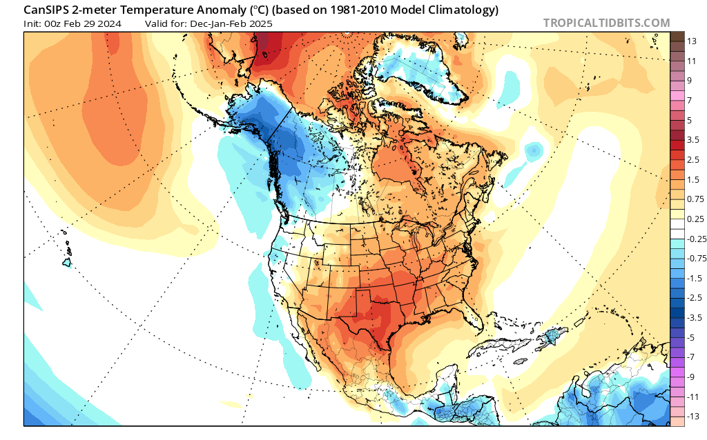
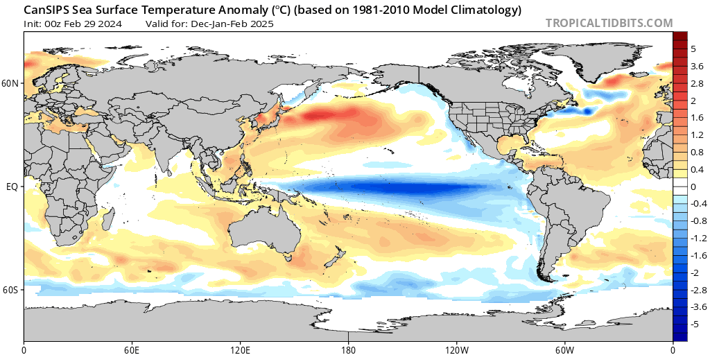
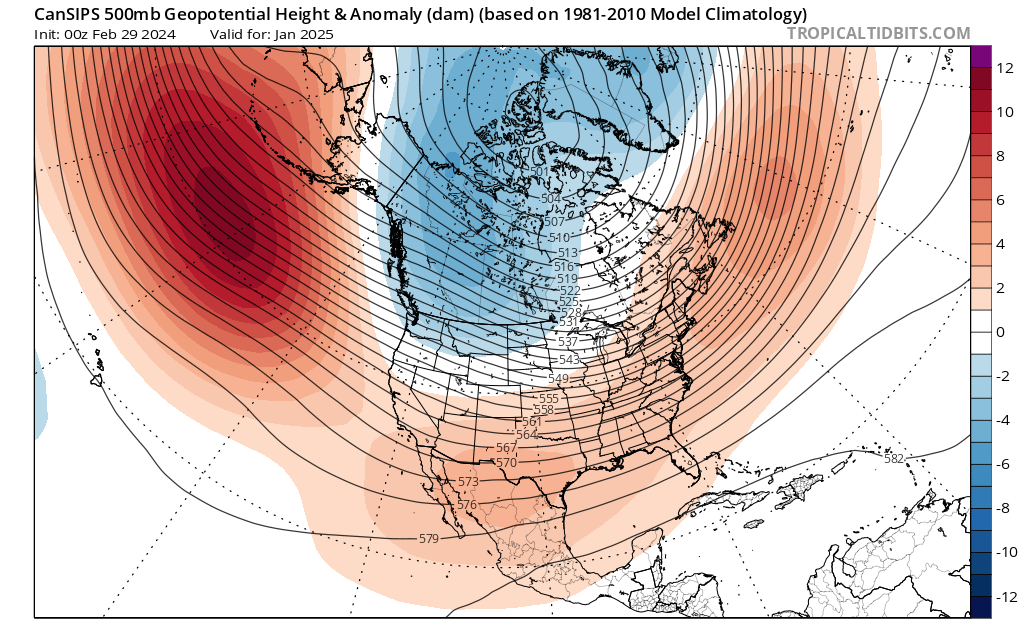
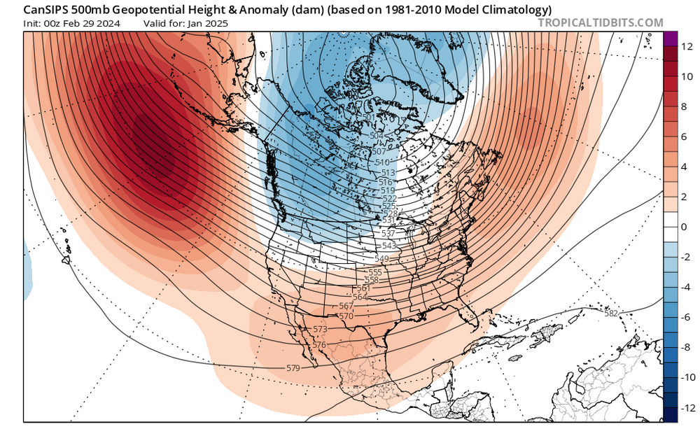
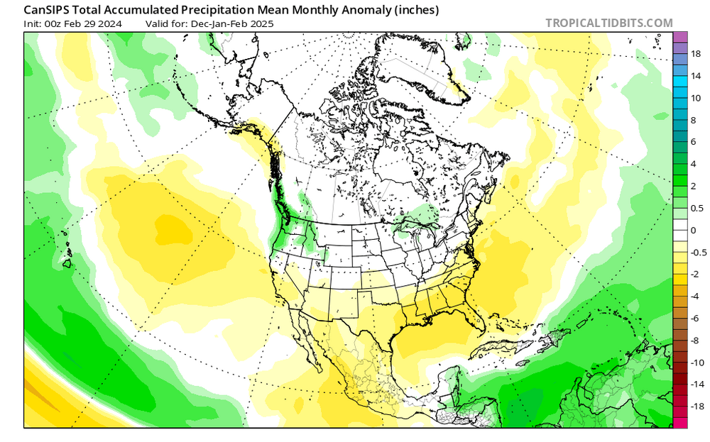
A look ahead to the 2024-25 winter... not for our own backyards, but WHERE to travel and chase (and when): New CanSIPs just came out, and it performed well on a smoothed/seasonal basis for this winter. It showed a wet first half, then a slightly drier second half, and a mostly warm CONUS with near normal/slightly BN southeast. So here's what it is showing for next winter now... 1) Moderate-strong La Nina, basinwide or even a little bit modoki. MJO should be active in the eastern IO through the MC (phases 3, 4, and 5). Negative PDO signature appears obvious, with that marine heatwave off Japan still ongoing and no signs of ceasing. 2) Standard La Nina h5 configuration enhanced by overall warming with a solid +AO/+NAO (or lack of blocking overall). Take away that -NAO block in December 2022 in the 2022-23 winter, then you'll get a good idea of what this winter is going to be like. 3) Again, a mostly warm CONUS just like this year, except the warmest anomalies are displaced south across New Mexico, Texas, and through the Tennessee Valley. (I wonder what raindancewx has to say about his backyard having the warmest anomalies). However, the west coast and Pacific Northwest are depicted to have near to slightly below normal temperatures. 4) Opposite to this winter, the south and southeast are depicted to be drier than normal. It would not surprise me if we got a hot and dry summer, with drought conditions redeveloping across the east. Wettest anomalies are shown over the Pacific Northwest, and with normal to slightly below normal temps, the mountains in that area could be the best places to chase. My brother lives in Spokane, and they may be set for a great/historic winter next year. Seriously considering an extended two-week visit there, renting a car, staying with him for 4-5 days, then drive to Montana's rockies for a few days, then back. Or if the Cascades are about to get a big one, we could chase there instead. Again, this is to show you where to plan your chases for next winter, not for snow in your backyards.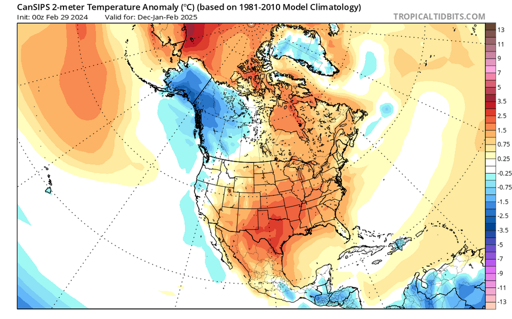

-
Late Feb/March Medium/Long Range Discussion
Terpeast replied to WinterWxLuvr's topic in Mid Atlantic
I don’t think we’re in a drought anymore, Will. I’m ready for sunny 60s/70s. Let’s see what severe weather season brings. Summer likely to be hotter and drier than the last few. -
Late Feb/March Medium/Long Range Discussion
Terpeast replied to WinterWxLuvr's topic in Mid Atlantic
What does your method say? -
Really bad situation on i-80 in ferocious blizzard conditions. I hope they all come out of this ok. They’re on their own right now http://newtoreno.com/ca-i80-webcams-sodasprings-wb.htm
-
What Went Wrong in Winter 23-24/Base State/Will It Ever Snow Again??
Terpeast replied to WxUSAF's topic in Mid Atlantic
That’s the best attitude we can have and carry through the year, and possibly through next winter. -
Late Feb/March Medium/Long Range Discussion
Terpeast replied to WinterWxLuvr's topic in Mid Atlantic
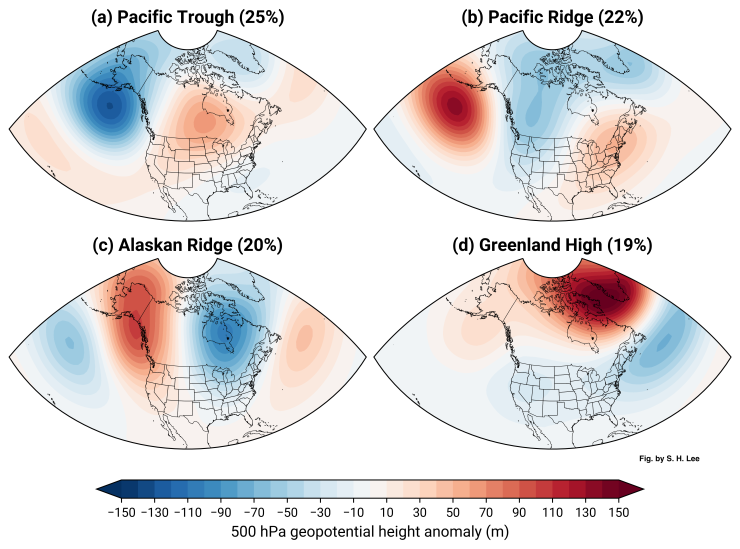
The biggest irony of this season is we got our best wintry week not from a nino STJ pattern, but more of a nina-like Alaska ridge pattern (-EPO) combined with a short-lived greenland block (-NAO). If we’re going to play the “everyone zigs, we zag” game, we better hope that two things happen at the same time during next year’s nina - 1) pac ridge nudges poleward into alaska AND 2) we get greenland blocking to hold any cold air down But my wag is that we don’t get any blocking, and we get 2022-23 without the cold xmas week. I’d pay money to be wrong.