Terpeast
-
Posts
6,690 -
Joined
-
Last visited
Content Type
Profiles
Blogs
Forums
American Weather
Media Demo
Store
Gallery
Everything posted by Terpeast
-
Late Feb/March Medium/Long Range Discussion
Terpeast replied to WinterWxLuvr's topic in Mid Atlantic
What does your method say? -
Really bad situation on i-80 in ferocious blizzard conditions. I hope they all come out of this ok. They’re on their own right now http://newtoreno.com/ca-i80-webcams-sodasprings-wb.htm
-
What Went Wrong in Winter 23-24/Base State/Will It Ever Snow Again??
Terpeast replied to WxUSAF's topic in Mid Atlantic
That’s the best attitude we can have and carry through the year, and possibly through next winter. -
Late Feb/March Medium/Long Range Discussion
Terpeast replied to WinterWxLuvr's topic in Mid Atlantic
The biggest irony of this season is we got our best wintry week not from a nino STJ pattern, but more of a nina-like Alaska ridge pattern (-EPO) combined with a short-lived greenland block (-NAO). If we’re going to play the “everyone zigs, we zag” game, we better hope that two things happen at the same time during next year’s nina - 1) pac ridge nudges poleward into alaska AND 2) we get greenland blocking to hold any cold air down But my wag is that we don’t get any blocking, and we get 2022-23 without the cold xmas week. I’d pay money to be wrong.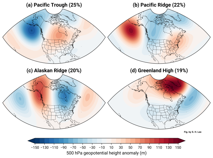
-
What Went Wrong in Winter 23-24/Base State/Will It Ever Snow Again??
Terpeast replied to WxUSAF's topic in Mid Atlantic
Not much difference, even though it felt much colder this year thanks to the mid-Jan wintry week with two SECS that trended the right way for us. -
What Went Wrong in Winter 23-24/Base State/Will It Ever Snow Again??
Terpeast replied to WxUSAF's topic in Mid Atlantic
I get your frustration around the lack of discussion of what's causing the ridge/trough flip. I notice this more and more, but tbh I don't have any good answers to offer as to what's causing this. Really. Gun to head, I'll still say "I don't know." I hope we get some real answers either from yet another shift in the pattern, or from climate scientists smarter than us publishing new papers on this. We could blame the MJO, but I think that's too convenient of a target. It could be the +EAMT since all the cold has been on the other side. It could be the Atlantic, but I'm not buying it 100%. Again, I hope the answers become clearer to us sooner than later. -
What Went Wrong in Winter 23-24/Base State/Will It Ever Snow Again??
Terpeast replied to WxUSAF's topic in Mid Atlantic
@psuhoffman I was just thinking that last year, CA mountains received record snowfall during a La Nina year, and now they are again getting record snowfall during an El Nino year. ENSO doesn’t seem to matter. I think that gives your posts about opposite pacific configurations giving the same western trough eastern ridge more validity than people seem to be giving it. I don’t know if this is caused by CC, or just part of a cycle. We used to have a persistent western ridge eastern trough for years while I was growing up here, and I thought that was a permanent fixture of north american climate. The opposite seems to be happening now, which makes me think it is more cyclical. -
I miss reading sky-is-falling AFDs with incoming HECS. Reading the reno and sacramento ones brings back a lot of memories
-
Late Feb/March Medium/Long Range Discussion
Terpeast replied to WinterWxLuvr's topic in Mid Atlantic
Just not cold enough. In late march it gotta be dark blue or green. -
Mountain West Discussion- cool season '23-24
Terpeast replied to mayjawintastawm's topic in Central/Western States
How were you able to find a place to stay at short notice? -
What Went Wrong in Winter 23-24/Base State/Will It Ever Snow Again??
Terpeast replied to WxUSAF's topic in Mid Atlantic
Interesting. I did see someone in the CT forum complaining that the snow under the death band was heavily rimed. He still got 40 inches. Btw, I was in one of the Buffalo LES events back in Dec 2001, one place got over 80" but where I was we "only" got 30-36". Kinda wild to see it go from 3 feet to barely an inch in just 15 minutes driving on I-90 east towards Rochester. The rest of the winter was crap, even up in Rochester. -
What Went Wrong in Winter 23-24/Base State/Will It Ever Snow Again??
Terpeast replied to WxUSAF's topic in Mid Atlantic
That was the year SNE got Nemo. I hope one day I can experience what they did under that >50dbz death band. Or I can just go to the Sierras. Or to Buffalo -
What Went Wrong in Winter 23-24/Base State/Will It Ever Snow Again??
Terpeast replied to WxUSAF's topic in Mid Atlantic
It was basin wide -
Late Feb/March Medium/Long Range Discussion
Terpeast replied to WinterWxLuvr's topic in Mid Atlantic
If this still looks workable inside of 7 days, then I shall track, too -
Late Feb/March Medium/Long Range Discussion
Terpeast replied to WinterWxLuvr's topic in Mid Atlantic
Part of me is rooting for a very strong nina to cool the oceans a tad, and hope for a few weeks of -EPO/-NAO. Just a couple/few weeks, then I’m wrapping it up as a winter. -
Late Feb/March Medium/Long Range Discussion
Terpeast replied to WinterWxLuvr's topic in Mid Atlantic
That’s my thinking. If the MJO is strong in phases 4-6 in October, it would catch my interest. @psuhoffman We haven’t seen a classic sustained PNA+ ridge out west for so long. Every ridge that tried to set up west just kept getting bullied, toppled over us, and brings SER-like warmth to our area. -
Late Feb/March Medium/Long Range Discussion
Terpeast replied to WinterWxLuvr's topic in Mid Atlantic
I guess it depends on which days. Sometimes what he says makes perfect sense and perfectly summarizes what was nagging in my mind and couldn’t put my finger on it. Other times, I’m like
-
Late Feb/March Medium/Long Range Discussion
Terpeast replied to WinterWxLuvr's topic in Mid Atlantic
In case the mods get pissed again about having to move posts - let me provide an easier solution: Simply change the name of this thread. You’re welcome. -
Late Feb/March Medium/Long Range Discussion
Terpeast replied to WinterWxLuvr's topic in Mid Atlantic
That’s where I disagree. Both air AND water are drivers working in tandem, not just air ON water. It’s a two way street. The marine heat wave off Japan is exerting its own influence and a powerful one at that. Zoom in on Japan, you’ll see SSTa off the charts. Take a look, and tell me that isn’t having any effect on the atmospheric pattern.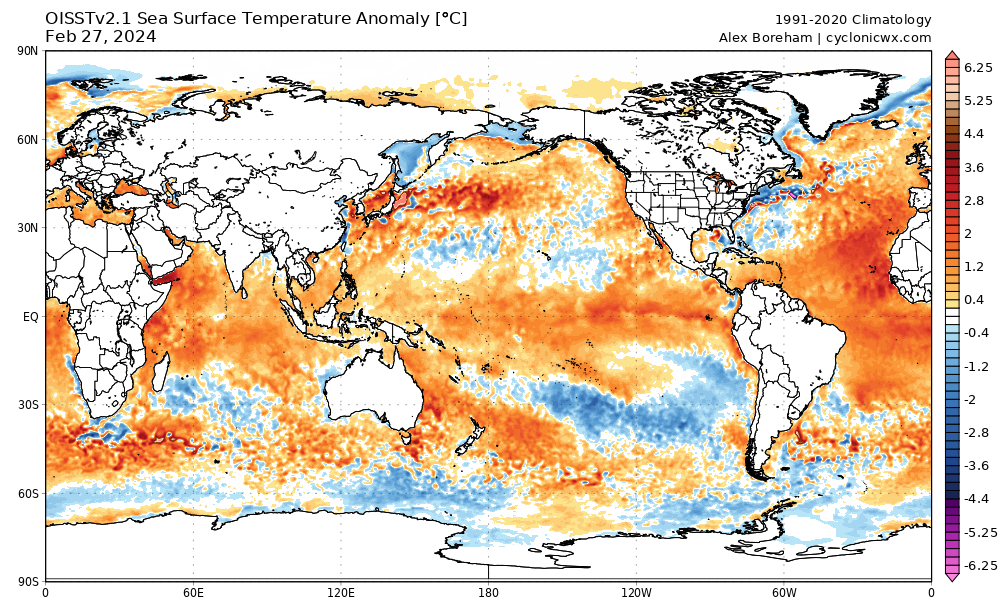
-
Late Feb/March Medium/Long Range Discussion
Terpeast replied to WinterWxLuvr's topic in Mid Atlantic
I don’t think the extreme -pdo is permanent either, but it’s quite the hole to dig out of. Not even a borderline super nino could get us out of that, although it got close but then it collapsed in Feb. We at least did get two SECS in Jan and a minor event in Feb, and that’s got to count for something within a 72-73 analog in a warmer world. -
Late Feb/March Medium/Long Range Discussion
Terpeast replied to WinterWxLuvr's topic in Mid Atlantic
One thing I’ll say about these LR charts is this. As long as we’re in a -PDO driven by the marine heat waves in the west pacific and off Japan, I would place no faith in LR charts no matter how good they may look. -
Late Feb/March Medium/Long Range Discussion
Terpeast replied to WinterWxLuvr's topic in Mid Atlantic
I'm just the messenger. Look at where Fukushima is on Google Maps, and then compare that location against the warmest SST anomalies on those two CFS forecast maps @GaWx above. -
Late Feb/March Medium/Long Range Discussion
Terpeast replied to WinterWxLuvr's topic in Mid Atlantic
The hottest SSTa of the marine heat wave is almost exactly where, and downstream of, Fukushima, the site from where they are dumping radioactive water. I haven’t come across any research that this is the cause, but I can’t seriously believe that this is a mere coincidence. -
Yeah, and it has to be on the pacific side. I don’t see how atlantic activity would help. Great article. The last line in this paper opens the possibility for a reversal to an el nino background state once the aerosol effect on enso runs its course (if they’re correct about the cause)
-
Late Feb/March Medium/Long Range Discussion
Terpeast replied to WinterWxLuvr's topic in Mid Atlantic
Good question. They aren’t so different in certain domains like ENSO, IO, MC, and even off the US West coast. But in the extra-tropical west pacific they could not be more different. I think part of the answer is that the marine heat wave off Japan is an extreme climatological event that is neither reproducible or predictable by any climate model, let alone any seasonal forecasting models. Find a way to dissipate that marine heat wave, then maybe we have a chance at colder winters again.