Terpeast
-
Posts
6,687 -
Joined
-
Last visited
Content Type
Profiles
Blogs
Forums
American Weather
Media Demo
Store
Gallery
Everything posted by Terpeast
-
Extended summer stormlover74 future snow hole banter thread 23
Terpeast replied to BxEngine's topic in New York City Metro
TT map for comparison (yes, it’s apples vs oranges) I mean, I don’t hate this map. With a cold source nearby, it could be workable. But CFS seems to be on its own, and it’s going to change 1000 times (probably correcting warmer in the last minute)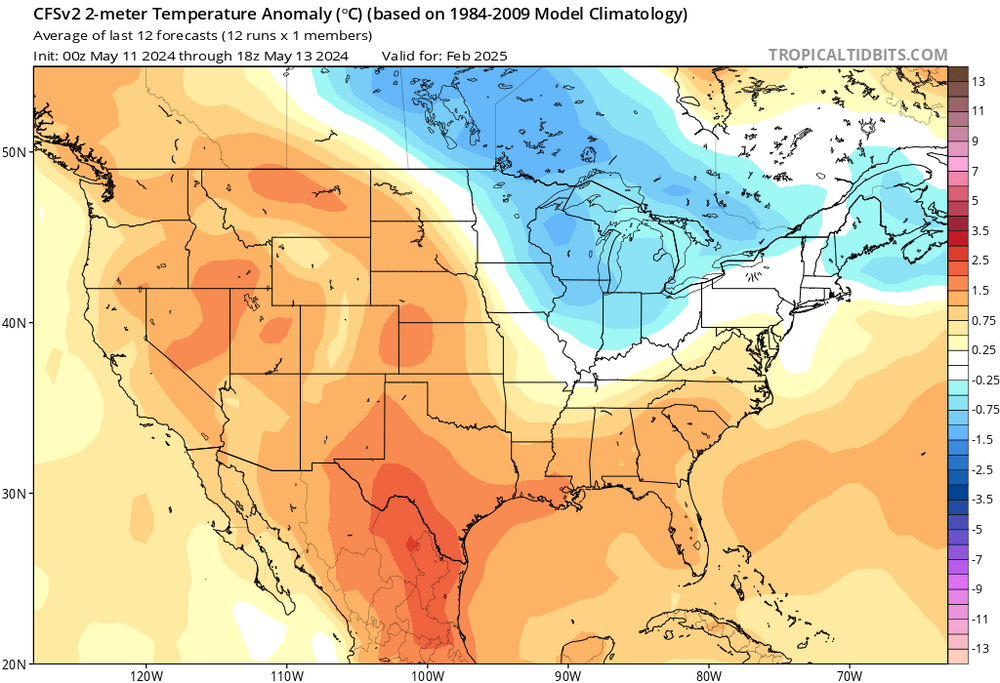
-
Extended summer stormlover74 future snow hole banter thread 23
Terpeast replied to BxEngine's topic in New York City Metro
By the daily WCS graph, it’s obvious that the strong nino made a dent in the -PDO, but nowhere enough to flip it positive. With waning nino influence, the PDO is right back as negative as it has been prior to the nino. It’s going to be a long time before the PDO goes positive, and I don’t know anymore what it will take to drive that. -
Worth noting that the magnitude of warm anomalies, however short-lived they may be, have been becoming more extreme and are skewing most months AN. If we have a month with 3 weeks of -2 departures, then 1 week of +15, that month is going to end up at least +3 AN or even higher. (You can play with the math and see how it works out) For example, remember that 80 degree day in this January? Take that day away, and Jan 2024 actually ends up just around normal temp wise.
-
Checked ouside at 3:30 am, didn’t see anything. One more chance tonight
-
Sunny out, hoping to catch curtain sightings tonight at around 9-11 pm before I go to bed
-

-
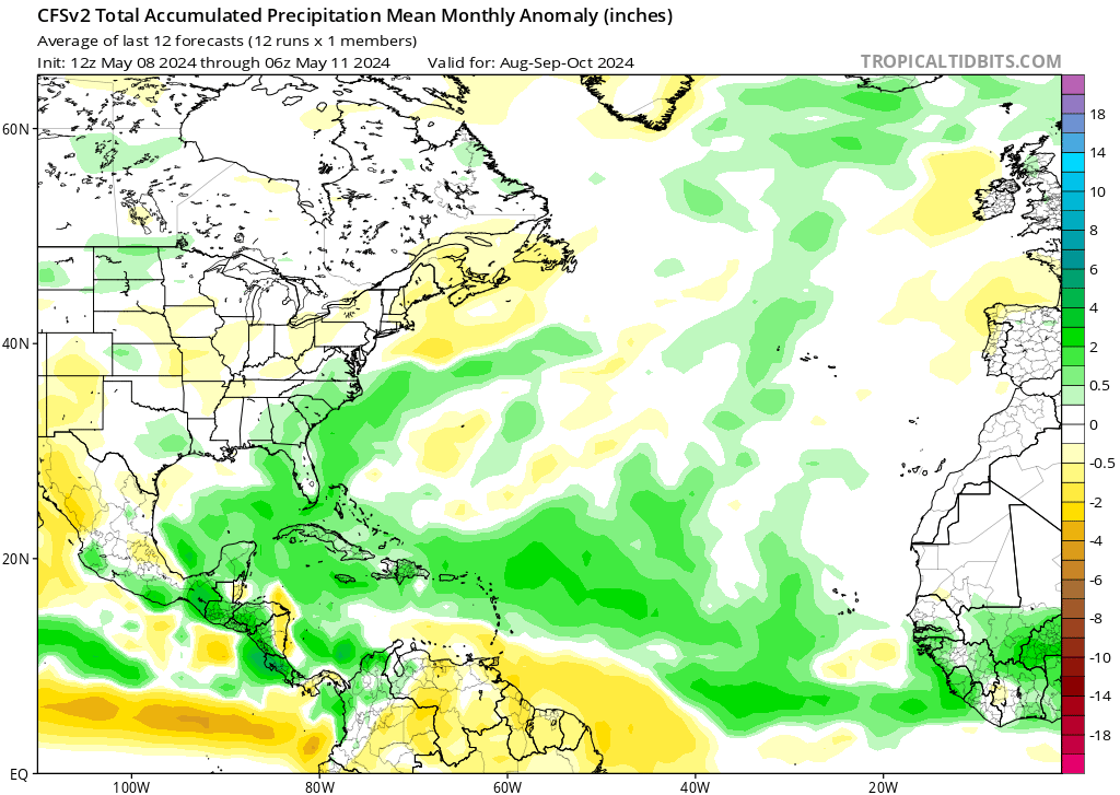
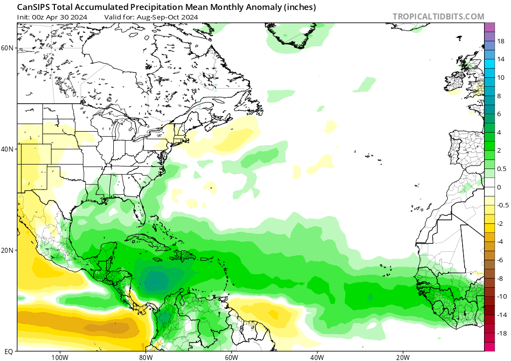
While we’re looking far ahead, CFS is projecting a crazy active tropics. I hope folks from lesser antilles up through VA beach are prepared to board up or have evac plans. If I lived in Florida, I’d be packing a Go bag right about now. CanSips - YIKES


-
Is it just WB or is the CFS predicting that most of the NH except the pole is gonna go colder than the 1981-2010 normal?
-
Missed it early this morning, but will BOLO for it tonight
-
Extended summer stormlover74 future snow hole banter thread 23
Terpeast replied to BxEngine's topic in New York City Metro
Although I didn’t think they were related before (couldn’t find a convincing enough link), I’m starting to believe that the AMO cycle leads to more SE ridge link ups with HL blocking. Do we know that if this happened in previous +AMO cycles let’s say, prior to 1980 or so? -
DCA 100 IAD 102 BWI 102 RIC 101
-
Extended summer stormlover74 future snow hole banter thread 23
Terpeast replied to BxEngine's topic in New York City Metro
And the north pac is progged even hotter (more deeply negative PDO) -
0.90” total so far both yesterday and today
-
Stepped outside of Dulles airport coming back from relentless SE Asian heat, hoping for some refreshing cool weather… NOPE!
-
Yes, please. Doctor just ordered prescription glasses with special lens that block out blue light. Said it was because I stare at a white screen all day for work.
-
Yes it will. But this depiction, in my opinion, is well supported by the combination of the projected nina + neg PDO + marine heat wave off Japan.
-
Yep, that’s where we are. And that’s not even the hottest spot… HCM is close to the coast so it gets some marine influence that limits high temps. Areas further inland, even the suburbs, have been routinely reaching 105. Brutal.
-
Reading this forum as they look for their first 90 degree day seems a bit quaint (no offense intended) as I’m here literally melting in 100 degree heat in Vietnam. It’s been hitting 100+ for more than a month now, through the entire duration of our 3-week trip here, and looks to last through late May. Southeast Asia has been baking, making me root for a strong nina so they could at least get some relief. They need it.
-
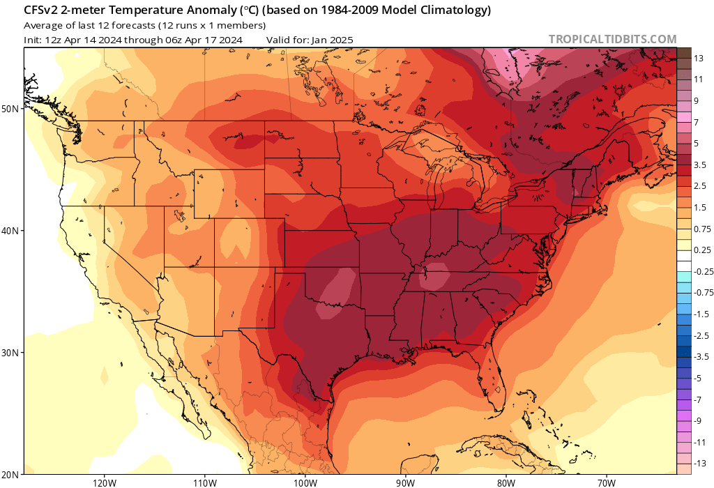
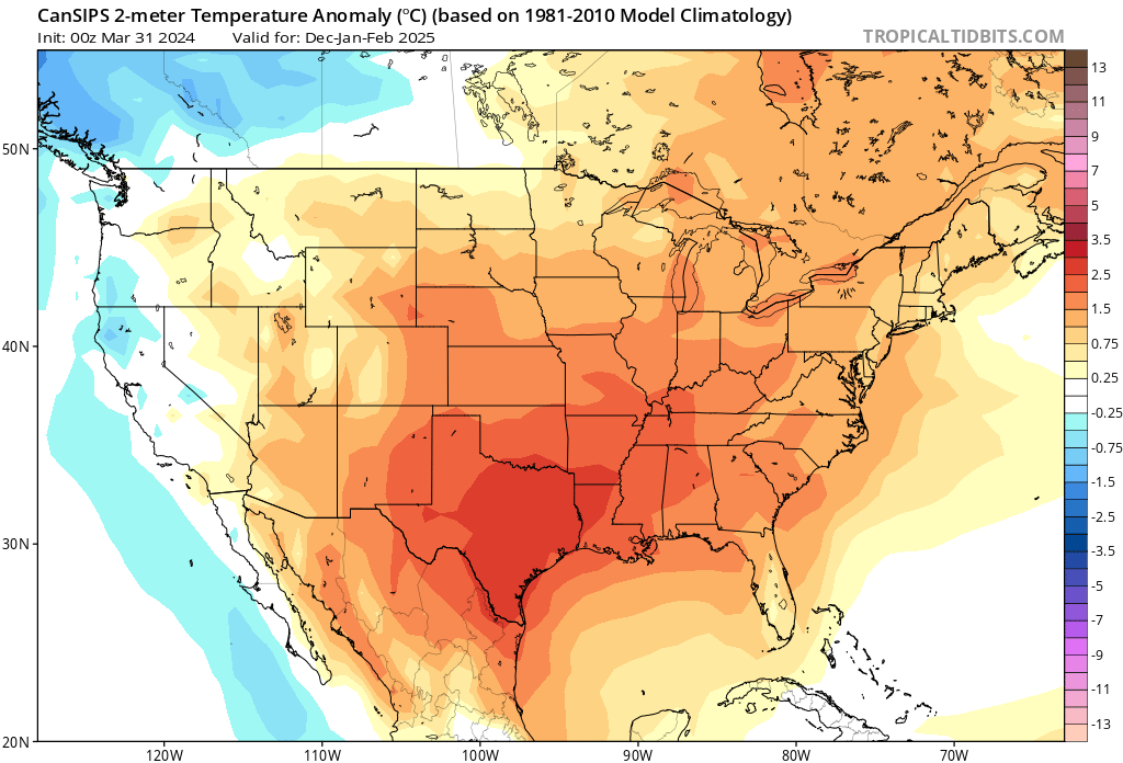
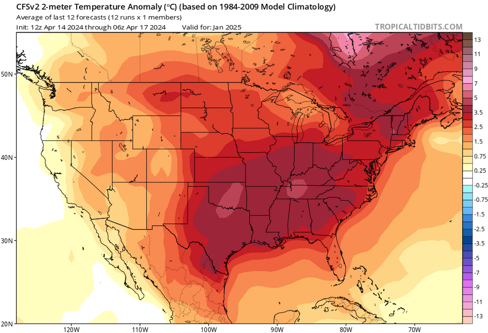
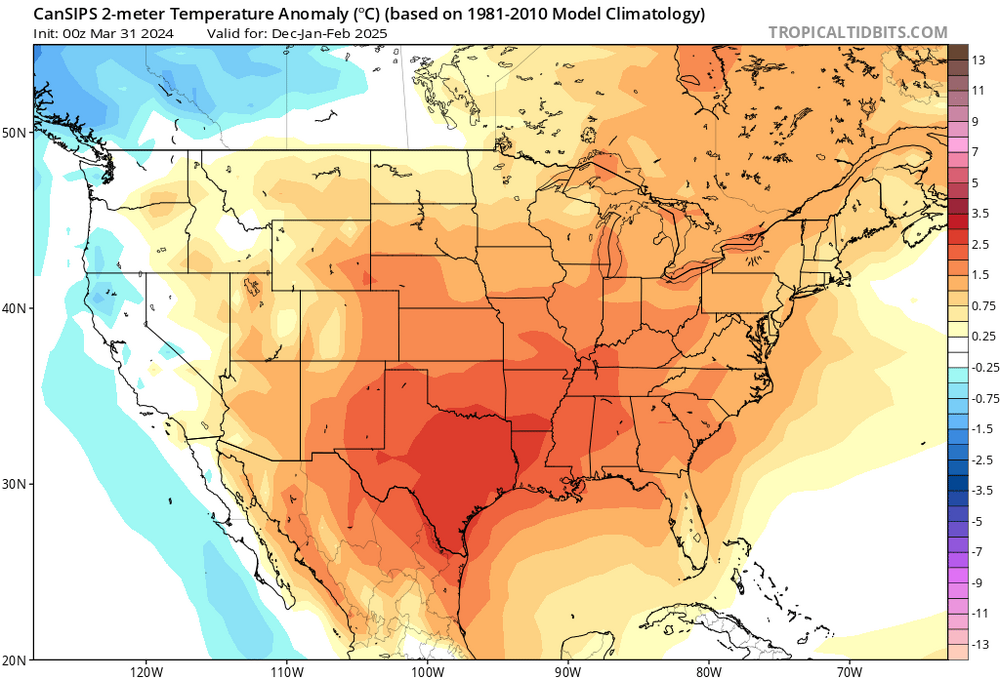
I know it’s way early, but CFS is thinking along similar lines for January. Cansips DJF
-
April 8th Eclipse- Last Easy One To See In My Lifetime
Terpeast replied to Interstate's topic in Mid Atlantic
Few minutes after peak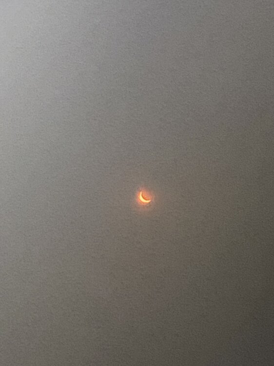
-
April 8th Eclipse- Last Easy One To See In My Lifetime
Terpeast replied to Interstate's topic in Mid Atlantic
That was cool, even though it wasn’t totality here. Amazing stuff even so. Sun was just a sliver. Felt the acute cooldown and dimdown -
April 8th Eclipse- Last Easy One To See In My Lifetime
Terpeast replied to Interstate's topic in Mid Atlantic
Getting close to 90% coverage -
April 8th Eclipse- Last Easy One To See In My Lifetime
Terpeast replied to Interstate's topic in Mid Atlantic
75% coverage now. Feels cooler, slightly darker. Sitting out on my deck with a beverage… lots of big black birds are out now all of a sudden… -
April 8th Eclipse- Last Easy One To See In My Lifetime
Terpeast replied to Interstate's topic in Mid Atlantic
Wow, you even captured the diamond ring effect! -
April 8th Eclipse- Last Easy One To See In My Lifetime
Terpeast replied to Interstate's topic in Mid Atlantic
Yet another deck incoming, when just a few minutes ago everything looked clear. Pretty sure it’ll stay thin enough. 35% coverage