

Terpeast
-
Posts
6,687 -
Joined
-
Last visited
Content Type
Profiles
Blogs
Forums
American Weather
Media Demo
Store
Gallery
Everything posted by Terpeast
-
84/77. Oppressive
-
Yeah if we bust west of 95, then we are in deep trouble with this drought. I don’t know how much more of this my trees and garden can take.
-
Yeah those clippers have been replaced by GL lows that always seem to interfere with the genesis of cold highs at the most inopportune times. It’s almost as if we need a strong PV to squeeze as far south as Ontario just to get those lows far enough south for DC to snow (like it did twice this January)
-
Climate change. And no, I'm not being flippant. It's easy to see that if the jet stream runs further north, then everywhere underneath and south of it will be above normal
-
Another 100 degree day in the bag. (99.7 but rounding up anyway) max HI 113!
-
98 so far for the high. Max HI 112. Sitting at 96 with lots of cloud cover
-
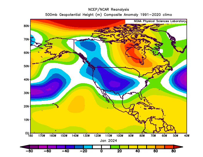
Another way we could get some help is an -epo block that happened in the middle of Jan. It was short lived so this plot has some noise, but we can see the cold air dumping into the CONUS. One pathway to this happening is the aleutian ridge pushing poleward through AK, which can occasionally happen in La Ninas. The biggest irony is that this wasn’t driven by El Nino. This was the only 10 day period when the STJ all but quieted down this winter. If I remember correctly, the MJO was in 3 before this pattern aberration occurred (and went onto 4-6 driving record warmth after the two MA snows). Your Jan 2022 scenario and this one are just about the best short-term wintery hits that we can hope for south of 40N in this coming winter, imo
-
99 for the high. I keep blowing past forecast highs due to dry ground
-
If this were winter...
-
93/71
-
87/72 here
-
Where are you hunkering down, specifically? I know you flew into Houston, but the eye is well west of the city Stay safe! Watch for broken glass and downed power lines. I lived through Ike in 2008, and it was… intense.
-
One could actually argue that the MJO was in 2/3 when the upstream conditions led to the storm.
-
Reached 97.5 for the high today, overperformed on temps but not on humidity
-
Once Beryl clears out of the CONUS, ensembles are showing hints of the WAR/bermuda high re-flexing westward into the eastern seaboard. Hotter and possibly drier than normal conditions appear likely to continue as it has been. Beryl, and its remnants, seems to be the only chance we have for an area-wide drought buster in the extended.
-
Ha, I’m starting to lose count how many times I’ve hit 100 imby, today included. definitely at least 3 times, but maybe 4 or even 5? And it’s not even mid July yet
-
High of 99.7
-
Made it to 99.1 today so far.
-
93 as of noon imby. Ashburn
-
I’m in Ashburn, a bit closer to Leesburg than IAD
-
Sister lives in Houston. Sent her a text yesterday to warn her
-
Same, I’m not going to jack up my water bill trying to save the grass. Only the essentials - garden, dogwood and fig tree
-
Even worse shape at 0.64” here since memorial day
-
Min of 77, wow
-
101! Hottest day this year

