Terpeast
-
Posts
6,687 -
Joined
-
Last visited
Content Type
Profiles
Blogs
Forums
American Weather
Media Demo
Store
Gallery
Everything posted by Terpeast
-
95 so far. A bit behind DCA and BWI, but with the dry ground, can catch up fast Edit: 97 now. HI 107
-
Down to 74, now 85. But it feels less humid. Dews at 68. Maybe I’ve acclimated somewhat.
-
Well, mby hit 100 today. Dews in the mid 60s though
-
Not even noon yet and it’s 93 already
-
Not the worst looking map, and with this configuration the MA is probably looking at quite a few wintry mix events, other than that mostly dry. But I think this model is going too cold across canada
-
It went up to 96 imby today. Supposed to be only 91. After getting whiffed on rainfall this weekend, I wouldn’t be surprised if mby overperforms on temps the next few days until precip chances increase.
-
0.3”. What a joke
-
Barely any precip so far today. Not going to put a dent in this drought. Disappointed.
-
Fighting dry air to the NW. hope the rain eventually wins out
-
Looking optimistic for rain. Radar looks decent, and all models show at least 1" imby
-
Don’t look now, we just hit a “cool” 90 at IAD and imby. Feels relatively nice though.
-
We still have a massive hole to climb out of. Last night helped (if you got rain), but it's not enough. We need a good 1-2 day soaker a week for a month or two to catch up. Long term, a bit of troughing between west/central US ridge and the WAR. We'll have plenty of SW flow to keep us hot and humid most days, but fortunately more chances for afternoon storms with the trough axis nearby.
- 1,696 replies
-
- 1
-

-
- severe
- thunderstorms
- (and 5 more)
-
Keep me posted, please!
-
Downloadable csv would be fine, but it’s your call and I can figure out how to scrape the data from whichever source you prefer. How about nao, ao, pna, wpo, and epo? Or are you focusing on ssts only?
-
I would indeed find the daily data useful because then I can join these indices with my own daily time series data… and do so many things with it. I prefer it in raw/tabular format so I can do my own visualizations. Including putting it through my own AI / machine learning model to find the most important relationships and make predictions based on that.
-
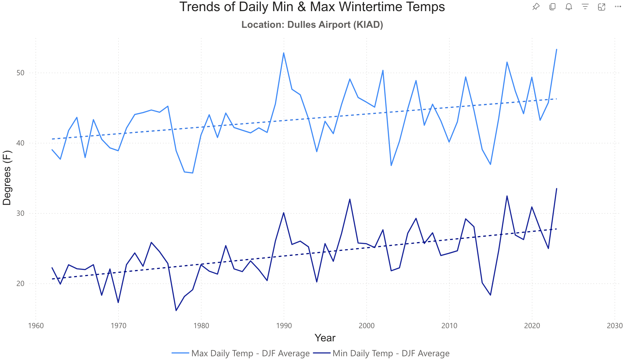
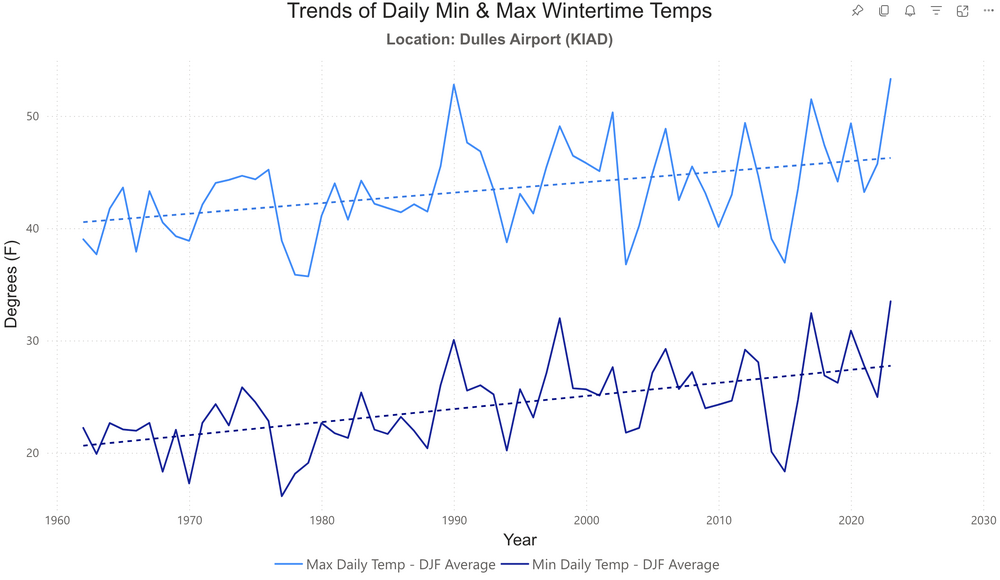
Based on KIAD data, both max and min are increasing... and the mins seem to be increasing just a little bit faster (steeper) than the maxes, but not by much. Maybe by a degree, or a degree and a half tops.
-
Interesting question… I can run that analysis for KIAD as a spot check for my region. Will update later today…
-
Well, that marine pool seemed to have shifted east as I compare the two maps. Maybe that has implications, or maybe it doesn’t.
-
Thanks for posting this. It's worth noting the ridge over the aleutian islands. That major ridge over far northern europe and NW eurasia is also remarkable, and makes sense in the context of ACE.
-
Decent rainer with some wind. Finally. nearest pws hasn’t updated their rain obs, but the next one to the SW reported 0.46”
-
Line is *trying* to get itself together west of the blue ridge. And then there’s the heavy rain threat later in the week. We just gotta capitalize on either one. Ideally both. If we don’t, we’re in serious trouble.
-
95/79 HI 114
-
High of 90 so far, clouds holding temps back a bit. But dews are off the charts (78-80) Even if I only get to 95 imby, it’ll still feel like 110
-
Even IAD didn’t get below 80 last night or this morning