Terpeast
-
Posts
6,687 -
Joined
-
Last visited
Content Type
Profiles
Blogs
Forums
American Weather
Media Demo
Store
Gallery
Everything posted by Terpeast
-
What Went Wrong in Winter 23-24/Base State/Will It Ever Snow Again??
Terpeast replied to WxUSAF's topic in Mid Atlantic
Not sure about DCA, but after today IAD has 11.7” on the season. Edit: DCA at exactly 8.0” -
What Went Wrong in Winter 23-24/Base State/Will It Ever Snow Again??
Terpeast replied to WxUSAF's topic in Mid Atlantic
That was with a more favorable pacific and +PDO -
Late Feb/March Medium/Long Range Discussion
Terpeast replied to WinterWxLuvr's topic in Mid Atlantic
All ensembles show a mslp track to our north and west, at least at 6z -
What Went Wrong in Winter 23-24/Base State/Will It Ever Snow Again??
Terpeast replied to WxUSAF's topic in Mid Atlantic
Hard to predict enso beyond the spring predictability barrier, let alone 2 years from now -
What Went Wrong in Winter 23-24/Base State/Will It Ever Snow Again??
Terpeast replied to WxUSAF's topic in Mid Atlantic
I think the Pacific cycle will flip soon, within a few years. Blocking, I’m not so sure because we’re about to enter a descending phase of the solar cycle. But the association between blocking and solar is tenously weak at best, so I could be wrong. And I’ve also observed that NS waves have been more juicy, which gave us a good January and the PA/NJ/NY crowd a great week this week. STJ waves have been too warm because they haven’t been able to sync up with cold air at all. If that changes, though, and we get cold air on our side, and we manage a STJ or phased wave, totals will be truly jawdropping. My wag, though, is that next year won’t be it. Maybe the year after. -
Late Feb/March Medium/Long Range Discussion
Terpeast replied to WinterWxLuvr's topic in Mid Atlantic
Well, that means we still have a chance -
Late Feb/March Medium/Long Range Discussion
Terpeast replied to WinterWxLuvr's topic in Mid Atlantic
So far LWX is leaning on the gfs over the euro, but it’s wide open now given recent model performance -
The Weekend Rule? Saturday 2/17 - The Icon Storm
Terpeast replied to DDweatherman's topic in Mid Atlantic
That fgen band was about 50 miles further north and much stronger than modeled. I saw this coming as soon as the dual band structure showed up and the north trend started. -
What Went Wrong in Winter 23-24/Base State/Will It Ever Snow Again??
Terpeast replied to WxUSAF's topic in Mid Atlantic
Those were the days. Luckily I have a photographic memory so it remains as real as the crispness of it in my head -
The Weekend Rule? Saturday 2/17 - The Icon Storm
Terpeast replied to DDweatherman's topic in Mid Atlantic
I’m tempted to have something to say about that, but after getting called out for being “too depressing”, I’ll just say that I’m soaking it all in right now -
The Weekend Rule? Saturday 2/17 - The Icon Storm
Terpeast replied to DDweatherman's topic in Mid Atlantic
Just went sledding with my daughter. Surprisingly good and fast! Happy to have gotten just enough for it and the rest doesn’t really matter -
Late Feb/March Medium/Long Range Discussion
Terpeast replied to WinterWxLuvr's topic in Mid Atlantic
That second January storm was the closest thing to cold smoke imby. Temp never got above 28 if I remember correctly -
Mid-Atlantic Snow Totals Thread - Winter 2023-2024
Terpeast replied to mattie g's topic in Mid Atlantic
12/11: 0.5” 1/1: T 1/6: 0.2" (sleet/snow mix) 1/15-16: 4.8” 1/19: 5.5” 2/13: 0.7” 2/17: 1.5” Season total: 13.2” -
The Weekend Rule? Saturday 2/17 - The Icon Storm
Terpeast replied to DDweatherman's topic in Mid Atlantic
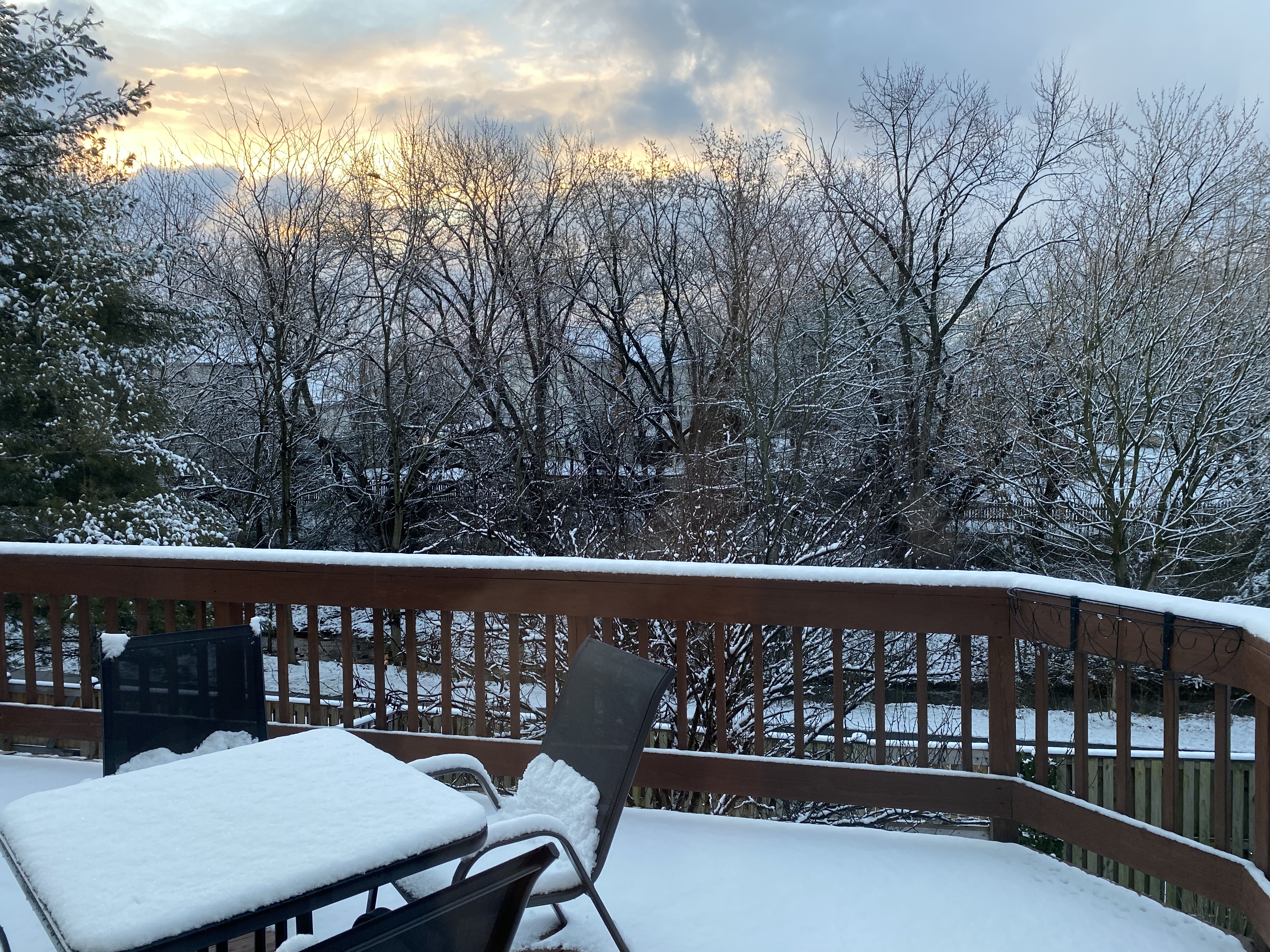
Final depth measurement 1.5”, even though quite a bit has melted since it stopped snowing. Might have gotten 2” of total snowfall, but I went to bed after my first measurement. So, 1.5” goes into my log. Still a beautiful wintry scene, I’ll make a coffee and enjoy it.
-
The Weekend Rule? Saturday 2/17 - The Icon Storm
Terpeast replied to DDweatherman's topic in Mid Atlantic
Still snowing heavily, everything is covered including pavement. May reach 2” before all done and I can go back to sleep. Looks maybe sleddable -
The Weekend Rule? Saturday 2/17 - The Icon Storm
Terpeast replied to DDweatherman's topic in Mid Atlantic
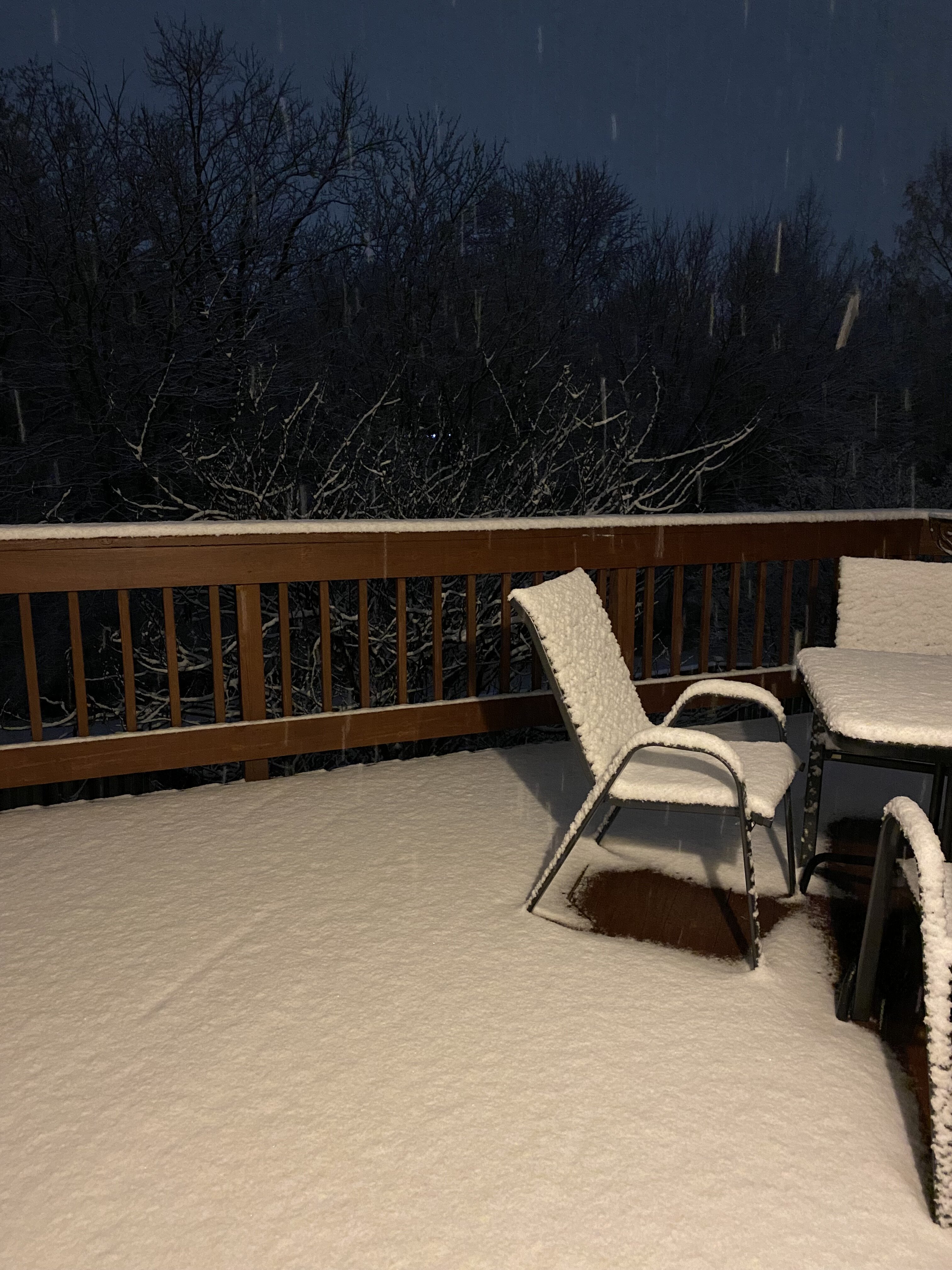
Didn’t take a pic of my measurement, but here’s the deck pic
-
The Weekend Rule? Saturday 2/17 - The Icon Storm
Terpeast replied to DDweatherman's topic in Mid Atlantic
1.5” and snowing. 32/31.8 -
The Weekend Rule? Saturday 2/17 - The Icon Storm
Terpeast replied to DDweatherman's topic in Mid Atlantic
Holding at 40, dews still 18-20. -
The Weekend Rule? Saturday 2/17 - The Icon Storm
Terpeast replied to DDweatherman's topic in Mid Atlantic
40/23 -
The Weekend Rule? Saturday 2/17 - The Icon Storm
Terpeast replied to DDweatherman's topic in Mid Atlantic
No more model analyzing from me as per y’all’s request. My final guess for mby - 3” And sending good vibes with this. Good luck!
-
The Weekend Rule? Saturday 2/17 - The Icon Storm
Terpeast replied to DDweatherman's topic in Mid Atlantic
Can’t deny the trends. I’m hoping for the best just as much as the next guy -
The Weekend Rule? Saturday 2/17 - The Icon Storm
Terpeast replied to DDweatherman's topic in Mid Atlantic
I do like this euro run, as well as the gfs. The CAMs are showing pretty different outcomes. It’ll all come down to banding, which I think is more likely to set up north near the m/d line -
The Weekend Rule? Saturday 2/17 - The Icon Storm
Terpeast replied to DDweatherman's topic in Mid Atlantic
39/18. If I get rug pulled (which is increasingly likely) it won’t be because of temps -
Late Feb/March Medium/Long Range Discussion
Terpeast replied to WinterWxLuvr's topic in Mid Atlantic
That wasn’t my idea, it was 40/70 benchmark -
The Weekend Rule? Saturday 2/17 - The Icon Storm
Terpeast replied to DDweatherman's topic in Mid Atlantic
Maybe I was right to call out the north trend yesterday. Hopefully the good radar out west means still good qpf totals on the southern edge (which I hate to be in)