

Terpeast
-
Posts
6,687 -
Joined
-
Last visited
Content Type
Profiles
Blogs
Forums
American Weather
Media Demo
Store
Gallery
Everything posted by Terpeast
-
Even if this La Nina stays weak-moderate, the surrounding warmth of the oceans and the West Pac will create a very strong La Nina state much like 2022-23. With a +QBO and solar cycle beginning to descend, we will likely have less blocking than even 2022-23. With all the cold air bottled up at the pole/Siberia or again dumping to the western NA, I'm thinking AN to much AN temps across the entire CONUS except maybe near normal over the Pac NW. East coast will likely be much AN+++ with 60s being commonplace, with strings of 70 degree days interspersed throughout even the deepest winter months. Warmest winter on record across the east? Even higher chance of that happening than this year and last year.
-
The Weekend Rule? Saturday 2/17 - The Icon Storm
Terpeast replied to DDweatherman's topic in Mid Atlantic
Between the euro and other models that trended souther/drier, I’d call it an overall hold. Still 3 days out -
You had breakfast with DT?
-
The Weekend Rule? Saturday 2/17 - The Icon Storm
Terpeast replied to DDweatherman's topic in Mid Atlantic
Its amazing what 10 days of wintry conditions in January has done -
Looks familiar. Where have I seen this before?
- 2,509 replies
-
- 6
-

-
- weenie fest or weenie roast?
- weenies got roasted
- (and 2 more)
-
The Weekend Rule? Saturday 2/17 - The Icon Storm
Terpeast replied to DDweatherman's topic in Mid Atlantic
Oy.. what have I done? -
The Weekend Rule? Saturday 2/17 - The Icon Storm
Terpeast replied to DDweatherman's topic in Mid Atlantic
I’m starting to prefer that. When we lose school days, the kiddo stays home and the only time she’s in a happy mood is when we’re playing outside in the snow. But if we’re not outside, it’s tantrum galore. Rather send her to preschool and keep the snow on weekends when she’s home anyway. That’ll change when she hits kindergarten or first grade, but for now… yeah. -
The Weekend Rule? Saturday 2/17 - The Icon Storm
Terpeast replied to DDweatherman's topic in Mid Atlantic
If the high end is only 3-4” and we’ve seen last minute shifts of more than 200 miles, then yeah I’d say it does matter I’m not saying cancel. I’m just not getting too invested until 24-48 hours -
The Weekend Rule? Saturday 2/17 - The Icon Storm
Terpeast replied to DDweatherman's topic in Mid Atlantic
Pretty sure the cmc and euro will juice up a bit more as it gets closer in time but the track? TBD, low confidence forecast when two bad models trend in opposite directions then there’s always the last minute shift within 24 hours - personality of the winter a la Bob Chill -
Yes, just probably not this year or next year.
-
Pretty much yea. At least we’ll be expecting that 10 months ahead of time. We’ll live.
-
Both this and last winter we at least had some blocking. Next winter we probably won’t. Not to the extent that we have seen anyway. I’d want to see wholesale changes in the pacific and for the atlantic to cool off to change my outlook. Until then, I’m setting fare alerts on Google flights.
-
The Weekend Rule? Saturday 2/17 - The Icon Storm
Terpeast replied to DDweatherman's topic in Mid Atlantic
I was also half joking, but it's true that the GFS isn't doing much better either. Maybe even worse than the ICON. If the GFS had support from other models, then yeah there's some credibility, but if it's alone it should be tossed. Even if it shows a snowstorm. -
I don't think PSU is depressing himself here. He's looking at the data, being realistic, and trying to give us a dose of realism. I may strike a more optimistic tone than PSU, but I mostly agree with him (like 95%). And although I'm usually an optimist, I'm pretty black-pilled about winter 2024-25.

- 2,509 replies
-
- 8
-

-

-
- weenie fest or weenie roast?
- weenies got roasted
- (and 2 more)
-
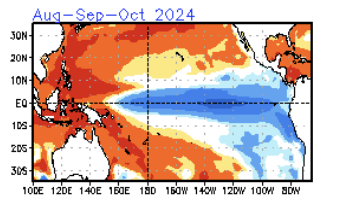
Annual family vacation to guaranteed snowy destinations. That's gonna be the way... Especially next year's Super Nina, +QBO, +AO, descending solar off a maximum, with continued marine heat waves off Japan and the West Pac warm pool. Did you see the CFS sst forecast in the NCEP ENSO update? Winter 2024-25 is going to be historic... and not in the way we want it. Look at this. Horrifying.
-
The Weekend Rule? Saturday 2/17 - The Icon Storm
Terpeast replied to DDweatherman's topic in Mid Atlantic
Too bad it's the ICON -
2024 Valentines Day Who the Hell Knows - Comeback Thread
Terpeast replied to DDweatherman's topic in Mid Atlantic
I was surprised we got ANY snowfall from this. Zero cold air, no NAO, we were coming off a warm pattern, and the "pattern change" was set to start with the passage of this storm. We don't usually get any snow at the beginning of a pattern change, usuaally in the middle or end of it. We wouldn't be having this conversation if this thing tracked north across PA and hit New England with a foot+ of snow. Instead we'd be saying, "ok this is the start of a pattern change, now let's start tracking." We (far N&W favored areas with elevation) got lucky with this one. -
Same, 7A. +6 since 2012. Hard to believe, since I ran the numbers on IAD and it's a more gradual +4 since 1962
-
2024 Valentines Day Who the Hell Knows - Comeback Thread
Terpeast replied to DDweatherman's topic in Mid Atlantic
Yeah, shift the whole thing a couple hours earlier before sunrise and I’d have gotten a couple inches. And this was a fast moving storm that just hauled its ass out of here -
2024 Valentines Day Who the Hell Knows - Comeback Thread
Terpeast replied to DDweatherman's topic in Mid Atlantic
As of 9:37 AM. That 0.6" 2 miles east of Leesburg checks out compared to mby. Should get a more complete set of obs by noon-ish. ********************STORM TOTAL SNOWFALL******************** LOCATION TOTAL TIME/DATE COMMENTS SNOWFALL MEASURED (inches) MARYLAND ...Allegany County... Potomac Park 2 NW 5.5 800 AM 2/13 Dept of Highways Bellegrove 1 SSE 3.8 831 AM 2/13 Trained Spotter ...Baltimore County... Lineboro 4 E 3.5 905 AM 2/13 Trained Spotter Bentley Springs 3 SS 2.0 834 AM 2/13 Trained Spotter Bentley Springs 6 S 2.0 900 AM 2/13 Dept of Highways Bentley Springs 1 E 1.0 720 AM 2/13 Trained Spotter Glyndon 1 SW 0.2 844 AM 2/13 Trained Spotter ...Carroll County... Manchester 6 WNW 4.3 916 AM 2/13 Trained Spotter Manchester 5 WNW 4.1 914 AM 2/13 Trained Spotter Taneytown NE 4.0 915 AM 2/13 Trained Spotter Taneytown 2.0 915 AM 2/13 Public Westminster 6 NE 1.5 833 AM 2/13 NWS Employee Uniontown 3 N 1.1 704 AM 2/13 Trained Spotter Westminster 1 NNE 1.0 800 AM 2/13 Dept of Highways ...Cecil County... Elkton 2 W 2.5 900 AM 2/13 Dept of Highways Rising Sun 1.0 907 AM 2/13 Trained Spotter Port Deposit 1.0 905 AM 2/13 Trained Spotter ...Frederick County... Sabillasville 3 SSW 4.5 831 AM 2/13 Trained Spotter Wolfsville 3 ENE 4.0 800 AM 2/13 Public Emmitsburg 1 S 3.0 759 AM 2/13 Emergency Mngr Ballenger Creek 1 E 2.8 900 AM 2/13 Dept of Highways Thurmont 2.8 910 AM 2/13 Public Bloomfield 2 WSW 2.4 800 AM 2/13 NWS Employee Utica 2 W 1.5 830 AM 2/13 Public Frederick 1 SE 1.0 830 AM 2/13 Trained Spotter Adamstown 1 ESE 0.9 920 AM 2/13 NWS Employee ...Garrett County... Grantsville 1 NE 7.0 815 AM 2/13 Near Grantsville Grantsville 6.5 800 AM 2/13 Public Grantsville 5 W 6.0 700 AM 2/13 Dept of Highways Frostburg 3 WNW 5.5 801 AM 2/13 Trained Spotter Deer Park 6 NE 5.0 700 AM 2/13 Trained Spotter Accident 4 E 4.8 700 AM 2/13 Public Oakland 4.0 521 AM 2/13 Dept of Highways Kitzmiller 5 NNW 3.8 800 AM 2/13 Swanton, MD ...Harford County... Norrisville 1 WSW 3.0 830 AM 2/13 CoCoRaHS Forest Hill 1 NNW 2.0 845 AM 2/13 Trained Spotter Fallston 3 N 1.0 826 AM 2/13 Trained Spotter Churchville 1 SE 0.5 800 AM 2/13 Dept of Highways ...Montgomery County... Damascus 3 SSW 1.6 934 AM 2/13 Co-Op Observer Washington Grove 1 N 0.5 919 AM 2/13 Trained Spotter ...Washington County... Fort Ritchie 1 NE 6.8 735 AM 2/13 Trained Spotter Fort Ritchie 1 NNE 6.5 700 AM 2/13 Public Funkstown 2 WSW 4.5 900 AM 2/13 Dept of Highways Boonsboro 3.7 840 AM 2/13 Public Pecktonville 3 NNW 3.6 822 AM 2/13 NWS Employee Rohersville 2 WNW 3.5 816 AM 2/13 Trained Spotter Boonsboro 3 NNE 3.3 900 AM 2/13 Trained Spotter Maugansville WSW 2.8 700 AM 2/13 Trained Spotter Hancock 1 ESE 2.8 809 AM 2/13 Trained Spotter Long Meadow 2 W 2.8 726 AM 2/13 Trained Spotter VIRGINIA ...Clarke County... Berryville 1 NNW 1.3 705 AM 2/13 Trained Spotter Berryville NW 1.0 700 AM 2/13 Public ...Fairfax County... Herndon 1 NNE 0.3 755 AM 2/13 NWS Employee ...Frederick County... Gravel Springs 4 W 4.5 923 AM 2/13 Trained Spotter Winchester 4 NW 3.5 929 AM 2/13 Public Hayfield 1 N 2.3 755 AM 2/13 Trained Spotter Winchester 3 E 1.8 816 AM 2/13 Public Winchester 2 WNW 1.6 715 AM 2/13 Trained Spotter ...Highland County... Hightown 3 NW 4.5 922 AM 2/13 Dept of Highways ...Loudoun County... Lovettsville 2.0 919 AM 2/13 Trained Spotter Round Hill 1 WNW 1.7 917 AM 2/13 Trained Spotter Leesburg 2 E 0.6 918 AM 2/13 NWS Employee ...Madison County... Big Meadows 1.5 615 AM 2/13 Park/Forest Srvc ...Nelson County... Wintergreen 4 NW 1.5 745 AM 2/13 At Devils Knob, 3500ft Wintergreen 3 NW 0.5 730 AM 2/13 Trained Spotter ...Prince William County... Woolsey 1 SW T 700 AM 2/13 Trained Spotter ...Rappahannock County... Chester Gap 2.0 900 AM 2/13 Trained Spotter ...Rockingham County... Massanutten 1 NNE 2.0 818 AM 2/13 Public ...Shenandoah County... Basye 2 NNE 4.0 823 AM 2/13 Public ...Warren County... Karo 1 WSW 0.6 830 AM 2/13 Trained Spotter WEST VIRGINIA ...Berkeley County... Martinsburg 2 E 3.0 858 AM 2/13 NWS Employee Falling Waters 2 NW 2.6 820 AM 2/13 Trained Spotter ...Grant County... Mount Storm 8.0 756 AM 2/13 Dept of Highways ...Hampshire County... Capon Bridge 5 WSW 5.0 910 AM 2/13 Public Romney 2 E 4.5 839 AM 2/13 Dept of Highways ...Hardy County... Wardensville 3 E 5.0 907 AM 2/13 Trained Spotter Moorefield 1 SE 3.0 830 AM 2/13 Public Moorefield 2.5 844 AM 2/13 Dept of Highways ...Jefferson County... Bloomery 3 SSE 3.7 913 AM 2/13 Trained Spotter Rippon 2 W 1.0 935 AM 2/13 NWS Employee ...Mineral County... Hartmansville 1 E 5.5 758 AM 2/13 Dept of Highways Burlington E 1.8 730 AM 2/13 Trained Spotter New Creek 1.5 758 AM 2/13 Dept of Highways ...Morgan County... Berkeley Spgs 4.5 820 AM 2/13 Public Berryville 4.0 850 AM 2/13 Public ...Pendleton County... Cherry Grove 6 WSW 5.0 753 AM 2/13 Trained Spotter Upper Track 1 N 2.3 829 AM 2/13 Public Deer Run 2 WSW 2.0 751 AM 2/13 Trained Spotter Franklin 1.8 829 AM 2/13 Emergency Mngr -
2024 Valentines Day Who the Hell Knows - Comeback Thread
Terpeast replied to DDweatherman's topic in Mid Atlantic
Congrats PSU! -
Beware the Last Minute South Trend™
- 2,509 replies
-
- 9
-
-
- weenie fest or weenie roast?
- weenies got roasted
- (and 2 more)
-
2024 Valentines Day Who the Hell Knows - Comeback Thread
Terpeast replied to DDweatherman's topic in Mid Atlantic
That extra 100’ in elevation plus being 15 miles west of me made a big difference for you -
2024 Valentines Day Who the Hell Knows - Comeback Thread
Terpeast replied to DDweatherman's topic in Mid Atlantic
Light snow became more moderate. Maintenance snow now -
2024 Valentines Day Who the Hell Knows - Comeback Thread
Terpeast replied to DDweatherman's topic in Mid Atlantic
Agreed

