Terpeast
-
Posts
6,596 -
Joined
-
Last visited
Content Type
Profiles
Blogs
Forums
American Weather
Media Demo
Store
Gallery
Everything posted by Terpeast
-
Makes sense if a -nao october is going to happen, unless the SE ridge links up with it. In which case the cold might not make it that far east. But up towards the great lakes, the likelihood is much higher.
-
Remnants of PTC8: Drought Denting Rain Event
Terpeast replied to Weather Will's topic in Mid Atlantic
Only added 0.07” since my last morning report -
Remnants of PTC8: Drought Denting Rain Event
Terpeast replied to Weather Will's topic in Mid Atlantic
Event total 0.97 so far -
Well, we thought a cold and active february was a lock even the last week of jan this year. Models were showing it for months. Then it slipped away at the last minute. You never know.
-
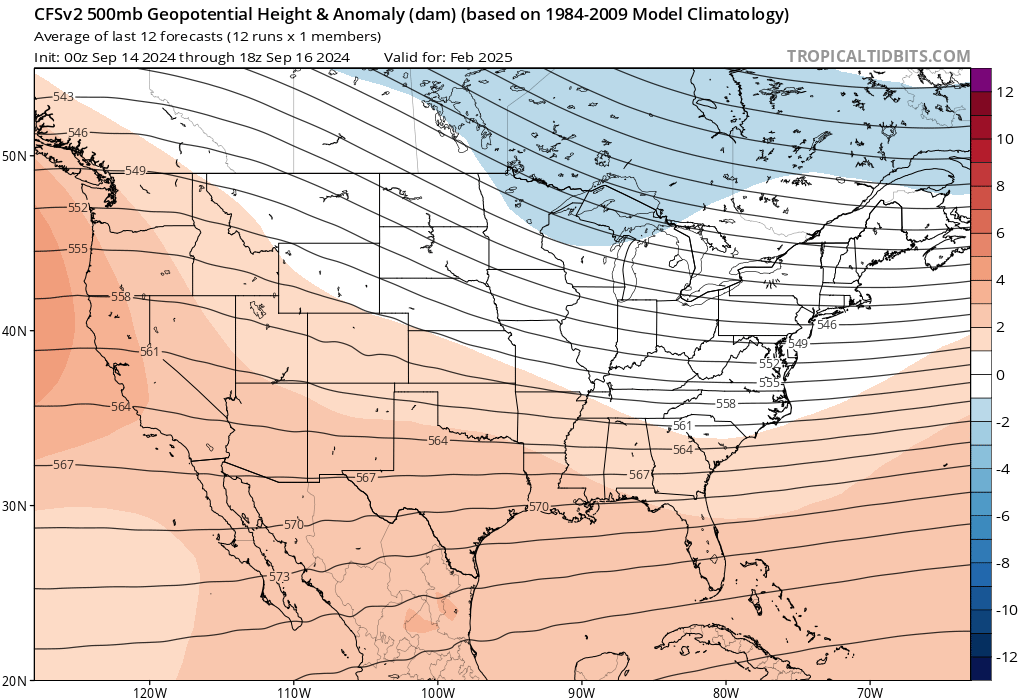
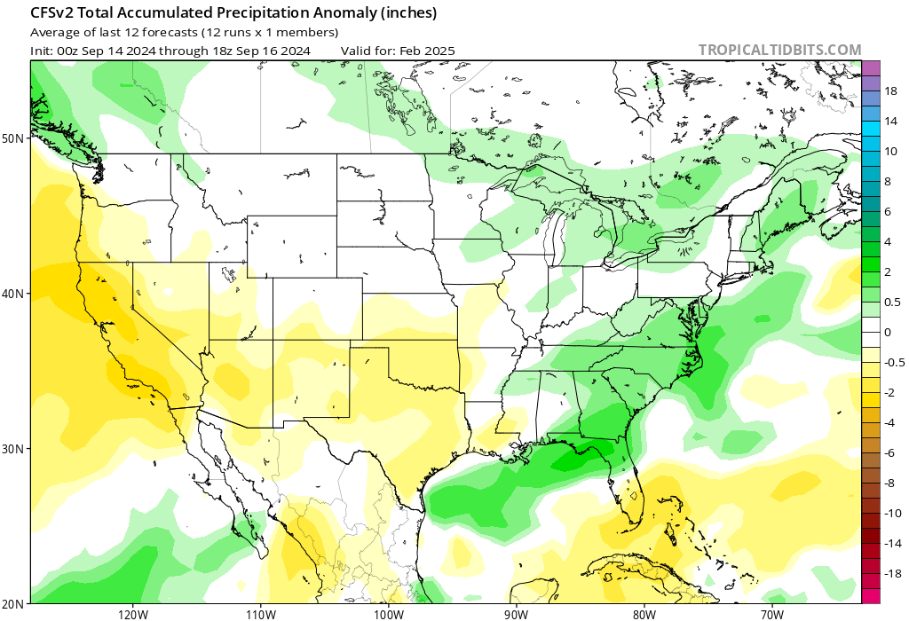
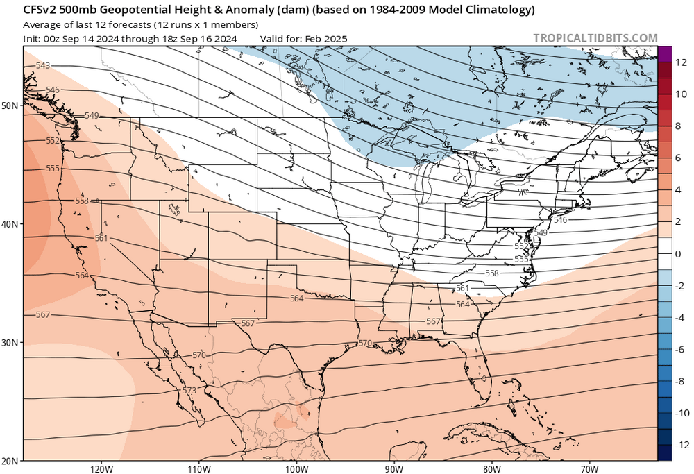
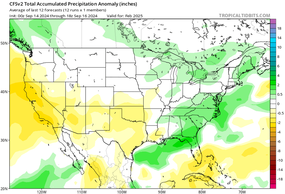
For a week in a row, CFS has shows February, not December to be the best winter month. Skeptical because it goes against the nina grain and what we’ve seen in the last several winters. Precip pattern shows a coastal track, too. Not particularly putting any weight on this, just not much more than a “hmm” moment.
-
Good. Still in a hole precip wise on the year.
-
Curious if the colder Feb is a reflection of a weaker Nina or cold neutral, as opposed to a stronger event?
-
With that record-breaking 500mb low over CA, one might think that a scenario with a stronger ridge over Canada would be more likely. But we shall see. I have no idea what will happen
-
Agree it is a statistical fluke. We had that Dec 2009 blizzard as well. In a -enso -pdo year like this, we need to score in that window to get something we wouldn’t look back on as a ratter.
-
It wouldn’t actually surprise me if December turned out to be our best winter month this year. The hope I hold onto is that it hangs on through part of January allowing us to get in on some action. October will tell us a lot more about where this thing is headed. @psuhoffman Have a great trip!
-
New CFS just came out, and boy it’s ugly. I mentioned watching the waters off the west coast, those ssts have cooled back down as the WPac marine heat wave got even stronger. I’ll do a brief outlook in October, not as detailed as last year’s. But my first guess is that we have about a 70% chance of a rat where we get only 0-3”. Only the upslope favored areas will do ok. One other thing I’ll say is that if you wanna chase snow, you may not necessarily have to fly west. I have a feeling there’ll be a monster lake effect event in Buffalo sometime late Nov through Dec. That’s your window if you want to get dumped on within a 7 hour drive of here.
-
Like Tip said, I suspect that non linear effects are involved. If just “adding” these effects together along with CO2 wasn’t enough to explain the global temp spike, then either something else is going on and we missed it (unlikely)… or the combination of these effects isn’t additive but rather multiplicative or heaven forbid, exponential.
-
Monster torch coming to central/eastern Canada through mid late month
-
45 so far
-
A degree C AN doesn’t sound too bad, but I wonder if NMME underestimates the magnitude of temp anomalies where the core of each anomaly is centered. Feels like I’ve seen this two winters in a row.
-
48 for the low. First 40s of the year, seems pretty early
-
Thanks for sharing. I agree with the general idea of a mild east and cold snowy west. Also with the torch Feb. My main hope is that January will be closer to average temp wise, which gives us more chances for snow before the Feb shutout. I’m in northern VA.
-
Congratulations Bob! I’m sure it’s a relief. Will be good to have you back this winter. Unfortunately it’s looking real ugly. All factors point to a warm and snowless winter in the MA. Then again, many factors pointed to a snowy winter last year, and we know what happened then… so idk.
-
If the reason behind quiet activity is that the ITCZ is too far north, I wonder if we’ll see a delayed but active period when the ITCZ starts moving back south. But by then it may be too late for MDR genesis
-
I don’t have a twitter account either. Well I had one, but deleted it.
-
Interesting you say that. Last year I did a quantitative analysis on how much CC has impacted our snowfall thus far, and found it to be roughly 16% using two different methods arriving at basically the same answer. But we haven’t seen a merely 16% reduction the last few years - its been way more than that. Either we’re still underestimating the effects of CC on snowfall, or we’re in an awful pattern - which is the point you seem to be making. The big question is whether this awful pattern as of late is being driven by CC itself.
-
Good post, and I agree after checking the new run. I’m a little more pessimistic than you after seeing how dry the 3-month average over DJF is currently depicted to be. But the saving grace is that Canada may not be torched this time like last year, and all it takes is a little well-timed cold push SE…
-
Just a brief shower. Fell apart pretty quick once it crossed over rt 15
-
Thanks for the laugh! Do you have some sort of beef with Boston, though? I’m genuinely curious.
-
Some people in the ENSO thread have been saying that this could be a version 2.0 of the 22-23 winter. Analog looks good, but I think there may be even less blocking this time than that winter unless the tropics start acting up soon. I’m trying to find paths to a decent winter, and aside from the EPO domain, I’m not seeing much.