

Terpeast
-
Posts
6,687 -
Joined
-
Last visited
Content Type
Profiles
Blogs
Forums
American Weather
Media Demo
Store
Gallery
Everything posted by Terpeast
-
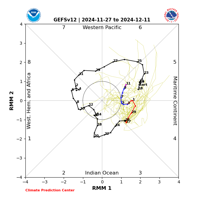
With those ssts being so warm, I don’t buy it… yet. But if this 4-6 pass trends weaker, the models may soon react to that and trend colder for the east. ETA both gfs and euro weeklies put the mjo at the end of phase 7 around last week of december, with varying levels of strength
-
45 and wet. The only thing that’s getting torched is the turkey in the oven. Happy thanksgiving!
-
If models are correct on a moderating trend end of second week of Dec, this coincides with MJO going into 5 at decent amplitude. My thinking is second half of Dec will be mild, NN to somewhat AN for the east until MJO goes into 7 and 8 sometime late dec or early jan, and that’s the next period I’m interested in. We should have more cold air to work with since Canada is almost entirely snow-covered.

-
That would be the second time in this calendar year
-
This coincides with the MJO going into 5 at decent amplitude. We may moderate back to NN or somewhat AN for a period of time around the 12th or so, but things may get interesting again once we get to 7/8 (maybe late dec or early jan) with a colder airmass the second time around. Still watching the clippers and the 12/8-10 window.
-
12z EPS shows the same thing. Less intense than GEPS, but we can work with that.
-
I see it too, its been on the models for a while. And more than one clipper too. TBD whether the precip makes it over the mountains and gives us some light snow.
-
Low of 33.6
-
Right where we want it?
-
I’m seeing the l/w pattern as more of a clippers/LES pattern. We’ve had plenty of that in the past before the 2010s onward, and while it got cold it wasn’t that easy to get snow. But we’ll see whether there’s a well timed s/w that digs enough to give us a snowstorm. Far too early to tell, but so far we have dec 1-2 and dec 5-8 windows to track. It may be similar to this past Jan where we did not see those 2 minor storms coming until they were starting to dig east of the rockies, and the models kept trending south until they were right on our doorstep.
-
IIRC the GEFS has always had a flatter pna ridge than the other models. GEPS the tallest/strongest, which gives us more cold but also more suppression risk
-
11/21: T (brief graupel) 11/22: T (non accum snow showers that lasted a few hours)
-
Low of 31.5
-
Except for the mountains, the qpf maps are almost the inverse of each other! Good test for the models and seeing which ones to trust more when we track the real stuff.
-
That’s crazy cold!
-
Yeah I picked up on that one too, I referred to it as the dec 2 clipper, but timing and wave characteristics will probably change
-
I don’t either, but to me that’s now the worst case scenario.
-
GEPS/EPS still has a signal for Dec 3-7, with maybe a clipper on Dec 2. GEFS looks totally dry. Still far out, so its probably noise. Ens haven’t budged on the cold.
-
I’m with bluewave on this one. After watching the entire NA continent experience its warmest fall in ages, on top of the warmest winter on record last year, we’re not gonna have much snow cover to start with. Soil temps are going to be warm. The positive takeaway from this is that a cold pattern is taking place early on, allowing time for more snow cover to get laid down over Canada and central US, which will help produce more local sources of cold air, which will only help the East through the rest of the winter. I’m just hoping we don’t get another 89-90 scenario where December gets cold, and then it completely flips warm and stays that way through Jan-Feb. I think there will be more variability than that.
-
Nice work. I’m on the same page. It’s tempting to say something like the winter pattern remembers the late Nov pattern, but I don’t think we see another 2013-14. I also think the chance of a total ratter has gone down a bit.
-
Honestly I don’t think you have much to worry about. I’m more interested in what happens after.
-
For Dec 3-7, GEPS still shows a signal for a coastal with plenty of cold, and EPS to a lesser extent. GEFS not picking anything up yet. Haven’t bought in for the Thanksgiving storm. I’m almost certain it will be rain for just about everyone except interior NE. Not cold enough yet.
-
Yeah either I was in a precip hole or the pws rain gauge undermeasured
-
45 now. Got 0.12” yesterday which was surprisingly little.
-
That’s the wave I have an eye on. GEPS had it on 0/12z


