Terpeast
-
Posts
6,687 -
Joined
-
Last visited
Content Type
Profiles
Blogs
Forums
American Weather
Media Demo
Store
Gallery
Everything posted by Terpeast
-
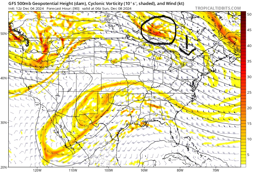
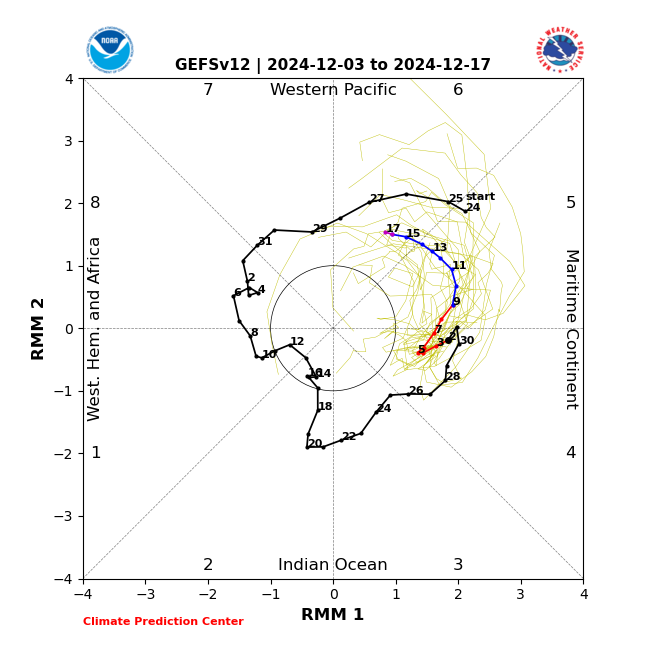
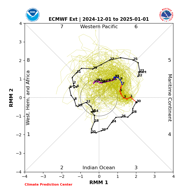
Even with GEFS being the warmest model 2 weeks out, it’s starting to bring the -epo back and with a trough south of GOA, we see it trying to rebuild a ridge out west. That timing is close to when it also brings the mjo to phase 7 (or almost there). For those of you who prefer VP anomalies, that takes the strongest forcing to near the dateline. From there, things can get interesting within the following 2 weeks or so. Maybe longer.
-
This is the first time I’ve seen most models in agreement. They never were about dec 5-6 nor about dec 8-10
-
Fair. If the MJO is gonna stay strong, then we want to root for it to get into 8 rather than going through 6 then womping into COD. Right now GEFS keeps it healthy well into 7, which is a transition phase for the east.
-
It seems the new Euro weeklies are trying to move the MJO along (or at least kill it off into COD) and produce a trough in the east. If it pans out (a big if) this second round might work better than this week when the cold pattern was fighting against forcing in phases 4-5. Definitely something to watch late Dec - early Jan.
-
Yeah, I mentally add +5 to warm anomalies a week out. If next tuesday is forecast to hit 65, then I’d say we’re gonna push 70
-
Key thing is we need that weekend clipper to trend further south, to get the boundary south for it to snow here. Can get it done, but we need it to trend for multiple runs over multiple days.
-
GFS and CMC shifted away from the follow up wave idea. Very much looks like snow is not in the cards this round, other than the potential little squall tomorrow morning early. Euro has been rock solid, and has been the better model lately (despite the flak it gets). Verification scores support this.
-
Bottomed out at 18.9
-
Yes, we’ll go milder for most of the month or even the rest of the winter, but I don’t think it’s as clear cut as some are making it out to be. I think there will be more variability this winter as we’re already seeing chinks in the -PDO/Nina armor. This 10 day cold period is probably the first out of 3-5 cold periods that’ll likely happen this winter. Ofc the minute it hits 60 degrees sometime in the next week, many will say “TORCH! Winter cancel!” For me, nothing has changed. It’s funny when it got cold over Thanksgiving, people were upping their snowfall guesses in that contest thread… while I stuck with my original guess (5-12” for the forum outside of the mountains).
-
My analog years: 1999-00 2008-09 2010-11 2017-18 2021-22 2022-23 So yeah, no I don’t think so. Maybe a 2021-22 though
-
His most recent tweet pointed to -EAMT with a barfing emoji. It sounds like he was capitulating out of frustration. Honestly I’m confused about his assessments in EAMT because he says the high pressure NW of himalayas with low pressure in the lee is -EAMT. Yet he also referred to the same pressure configuration as +EAMT in both Dec 2018 and in 2020-21. So which is it?
-
Both 18z gfs and 12z AIFS have a follow up wave after the cutter. It’s rain for now, but close. Any colder, it’ll be wintry.
-
Rather than a full blown SSW, we may have a reflection from a wave breaking event this month. Just not sure what the implications are. I’d have to dig more into it and see if it’s worthwhile posting more details.
-
The fact that the CFS caught it early lends more credibility to that model.
-
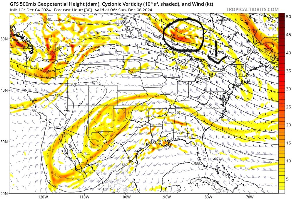
Notice all models are now “trying” to keep the western ridge going in the medium range…
-
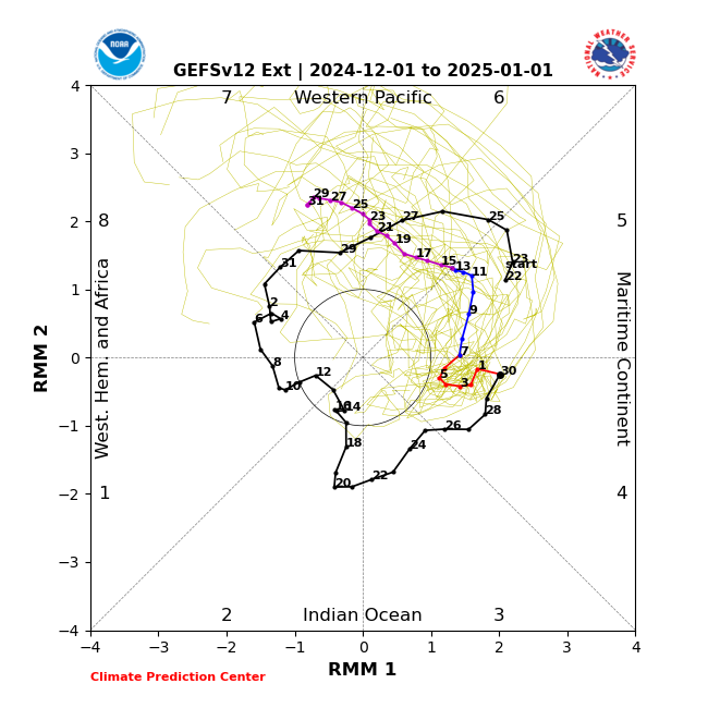
Extended GEFS & EPS are very different after around dec 15 in handling the MJO, which will likely have implications for late Dec even early Jan.
-
GEFS and EPS while in lockstep with the mid-month moderation, they diverge because EPS wants to maintain -EPO the rest of the month and keep cold air nearby, while the GFS flattens the Alaska ridge a bit giving NW US/SW Canada less cold.
-
Kill off the bugs early. Never a bad thing.
-
I think extra variability will be the story of this winter. For now, the warm pool via MJO 5-6 is starting to exert its influence, but as I’ve been saying for almost a month now, the period I’m watching is when the MJO completes its pass through 6 entering 7/8/1 and the +AAM comes back at the same time. Still estimate that to be late Dec - early Jan, but sometimes models rush a pattern change, so it could be after the New Year. I could be wrong about the specifics, but again I think we’re going to see more variability.
-
Low of 25
-
Yeah, the models have been pretty shaky and I think thats going to be the story of the entire winter.
-
Thought the strat PV is staying strong for the foreseeable future. Got any new data on that? And a strat warm is no guarantee of a cold outbreak here. It could spill to the other side or to Europe. We better hope that EPO stays negative if we get a strat warm.
-
Carver’s Gap just posted euro weeklies in the TN forum. Not a lot to complain about…
-
11/21: T (brief graupel) 11/22: T (non accum snow showers that lasted a few hours) 12/1: T (snow shower that briefly dusted)
-
Light snow. Finally! Car top starting to get dusted.